Annotating Geographical Entities on Microblog Text
Koji Matsuda1,Akira Sasaki1,Naoaki Okazaki1,2, andKentaro Inui1
1Graduate School of Information Sciences, Tohoku University
6-6-05 Aramakiaza-Aoba, Aoba-ku, Sendai, 980-8579, Japan
2Japan Science and Technology Agency (JST)
1{matsuda,aki-s,okazaki, inui}@ecei.tohoku.ac.jp
Abstract
This paper presents a discussion of the prob-lems surrounding the task of annotating geo-graphical entities on microblogs and reports the preliminary results of our efforts to anno-tate Japanese microblog texts. Unlike prior work, we not only annotate geographical lo-cation entities but also facility entities, such as stations, restaurants, shopping stores, hospi-tals and schools. We discuss ways in which to build a gazetteer, the types of ambiguities that need to be considered, reasons why the anno-tator tends to disagree, and the problems that need to be solved to automate the task of notating the geographical entities. All the an-notation data and the anan-notation guidelines are publicly available for research purposes from our web site.
1 Introduction
The ability to analyze microblog texts according to a spatial or temporal axis has become increasingly im-portant in recent years. For example, with Twitter, users can share knowledge of situations and sight-ings of events at a low cost, with much of the in-formation being integrated in the form of natural language. If it were possible to anchor these posts (known as “tweets”) to specific locations in the real world, this would benefit a wide variety of applica-tions such as marketing, social surveys (Li et al., 2014), disease monitoring (Signorini et al., 2011; Collier, 2012), and disaster response (Middleton et al., 2014; Ohtake et al., 2013; Varga et al., 2013).
For example, with respect to natural disasters, such as the 2011 Tohoku earthquake, large amounts
of information were posted on social networking services (SNS), and some of these posts offered in-formation that could aid rescue operations.
In this paper, we discuss the language expressions that are used, in particular those representing a “spe-cific location”. For example, expressions that refer to a location (henceforth referred to as “location ref-erence expressions”, LRE) are often mentioned in such SNS posts, and if it were possible to associate a specific set of coordinates with an area (ground-ing), this text information could be transferred to a map. By mapping tweets posted during disasters on time and spatial axes, it would possible to gain an improved understanding of a disaster situation.
In this case, it seems that it would be possible to use GPS information that has been attached as metadata to tweets. However, whether GPS infor-mation is included in tweets is controlled by the user, in their client settings. It was reported in a recent study (Middleton et al., 2014) that less than 1% of tweets have GPS information appended to them. LREs are expressed in natural languages in the tweet, and an analysis would make it possible to map the actual spatial entity. As explained above, even though there is a large demand for this kind of application, a corpus that annotates geographical en-tities to LREs in microblog texts does not currently exist.
In this paper, we report the results of the trial that was conducted with the aim of creating a corpus that annotates specific entity information with the coor-dinate information to LREs appearing in Japanese texts sampled from microblogs. We provide details as to how we made the decisions on the various
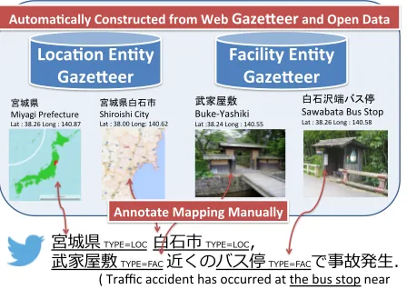
宮城県 TYPE=LOC ⽩白⽯石市 TYPE=LOC,
武家屋敷 TYPE=FAC 近くのバス停 TYPE=FACで事故発⽣生.
白石沢端バス停 Sawabata Bus Stop
Lat : 38.26 Long : 140.58
Loca%on En%ty
Gaze.eer Facility En%ty Gaze.eer
Annotate Mapping Manually
Automa%cally Constructed from Web Gaze.eer and Open Data
宮城県 Miyagi Prefecture
Lat : 38.26 Long : 140.87
宮城県白石市 Shiroishi City
Lat : 38.00 Long: 140.62
武家屋敷 Buke-‐Yashiki
Lat :38.24 Long : 140.55
Figure from : Wikipedia, Google Maps. ( Traffic accident has occurred at the bus stop near
[image:2.612.74.298.71.230.2]the Buke-‐Yashiki , Shiroishi-‐City, Miyagi-‐ken )
Figure 1: Overview of the corpus
sign aspects, how we built the entity gazetteer, and how we defined the representation of the annotated target. In addition, we describe how the validity of the proposed schema was verified by having it anno-tated by multiple people and we describe the prob-lems identified from the results of this verification.
As will be discussed later in this paper, not only location names, but also facility names often appear in microblog texts. We compiled a large (more than 5 million entries) gazetteer of locations and facil-ity entities from data obtained from the Web, and managed to annotate about 40% of these entities (an eightfold increase on previous work) with facility names for which the writer assumes a specific lo-cation.
Finally, we analyzed part of our corpus to enable us to discuss the technical problems that would need to be resolved to perform the grounding of LREs. The resulting corpus, documentation, and annota-tion guidelines are available on our web site1.
2 Related Work
Studies that automatically annotate location infor-mation according to text are basically divided into the following types: The first isDocument Geolo-cation, that is, inferring the location information for the whole of the given text. A typical example of this form of research is the automatic annotation of
1http://www.cl.ecei.tohoku.ac.jp/
∼matsuda/LRE corpus/
location information in Wikipedia articles, or infer-ring the residency of a Twitter user. This approach is mainly used for supervised learning, with text con-verted to feature representation. However, it has been reported that this method does not work well on short documents such as tweets (Schulz et al., 2013). A contrasting approach assigns specific geograph-ical entities by automatgeograph-ically analyzing LREs to identify information such as a toponym that ap-pears in the text (Geoparsing, Toponym Reso-lution) (Leidner, 2007). Speriosu and Baldridge (2013) proposed a supervised learning method by using an indirect supervision technique. DeLozier et al. (2015) proposed a gazetteer independent method by using density estimation techniques.
These studies were evaluated by using a refer-ence corpus such as the TR-CoNLL (Leidner, 2007) or LGL(Local-Global Lexicon) (Lieberman et al., 2010) corpus. However, these corpora are annotated only by location entities, and not by facility entities. In addition, existing corpora have mainly been com-piled from the newspaper domain.
Our main aim is the analysis and mapping of so-cial media text; therefore, we need to investigate the behavior of different toponym resolution methods on social media text. This prompted us to annotate text sampled from SNSs.
Mani et al. (2010) annotated location information to text, by annotating both the location and facility entities, but their corpus is sampled from the ACE corpus, which is drawn mainly from broadcast con-versations and news magazines. However, in our in-vestigation of their corpus, out of all the LREs in the expressions that were annotated, only 5% were tagged as “Facility”, and these were only very pop-ular entities such as “the Pentagon” and “the White House”.
In contrast, as our corpus study reveals below, real-life microblog texts include as many mentions referring to facilities whose location can be uniquely identified as are mentions referring to location enti-ties. The annotation of these facility-referring men-tions poses interesting research challenges, which motived our corpus study reported in this paper.
GeoNLP (Kitamoto and Sagara, 2012) exist, but there are no reports of quantitative evaluations of the performance, because there is no corpus for evalua-tion.
3 Challenges in Annotating LREs on Microblog Text
In this section, we describe the new research chal-lenges associated with annotating geographical enti-ties in Microblog text and our policies for addressing these issues.
3.1 Systematic Polysemy of LREs
One prominent issue in annotating facility entities is the so-called systematic polysemy inherent in men-tions referring to facilities (see, for example, Peters and Peters (2000)). For example, the mention “the Ministry of the Environment” in the sentence (1) be-low refers to a specific location while the mention “the Ministry of the Environment” in (2) should be interpreted as an organization and does not refer to the location of the organization.
(1) 午 後 は 環境省 に い ま す / I’ll be at
the Ministry of the Environment this after-noon.
(2) こ れ か ら 環境省 の 職 員 に 会って き ま す
/ I will go to meet a staff member of the Ministry of the Environment.
This distinction can be crucial in potential appli-cations of annotated geographical entities. In our an-notation guidelines, ambiguities of this nature need to be resolved.
3.2 Analysis of not annotated examples
Another issue in annotating facilities in microblogs is how to manage cases in which a mention refers to a certain (unique) facility entity, but the reader (annotator) cannot resolve it to any specific entry in the gazetteer by only using the information from the local context. For example, the mention ”the park” refers to a certain unique location but the local con-text provides insufficient information for identifying it.
(3) 公園 でスケボーしてる人達眺めてる / I’m
looking at the people skateboarding in the park.
According to our corpus study, roughly 50% of facility-referring mentions in our microblog text samples cannot be resolved to a specific entry in the gazetteer. One straightforward way to manage these type of mentions is to discard all common noun phrases from the targets of our annotation. However, since one can also quite often find common nouns that can be resolved to a specific gazetteer entry as in Figure 1, it is intriguing to see the distribution of such cases through a large corpus study and consider the task of building a computational model for ana-lyzing them. Motivated by this consideration, we incorporate the following two tags in our annotation specifications:
Underspecified (UNSP) indicates that the tagged segment refers to a certain unique geographi-cal entity but is not identifiable (i.e. cannot be resolved to any entry from the gazetteer). Out of Gazetteer (OOG) indicates that the
refer-ent of the tagged segmrefer-ent is a geographical en-tity and can be identified, but is not included in the gazetteer.
3.3 Building a Gazetteer of Facility Entities Another problem we faced was to decide how to build a gazetteer. For location entities (toponyms), it tends to be easier to find a comprehensive list from public databases such as GeoNames (Leidner, 2007; Middleton et al., 2014). For facilities, on the other hand, since the referents of LREs in microblogs in-clude a broad variety of facilities, including stations, restaurants, shopping stores, hospitals, and schools, it is not a trivial job to build a comprehensive list of those facilities with a sufficient coverage even if the targets are limited to a single country.
For our corpus study, we were fortunate to be able to use the data collection from the Location Based Social Networking Service (LBSNS) as reported in Section 4.2. However, our corpus study suggests that our gazetteer still needs to be extended to en-sure improved coverage. In addition, we also had to determine ways in which to share the database with other research sites.
4 Annotation Specifications
is-東京から新幹線で岩手県まで行く /
I go to Iwate prefecture from Tokyo in Shinkansen.
[東京 TYPE=FAC] から [新幹線 TYPE=FAC] で [岩手県 TYPE=LOC] まで行 く / I go to [Iwate prefecture TYPE=LOC] from [Tokyo TYPE=FAC] in [Shinkansen TYPE=FAC].
[東京 TYPE=FAC, EN=東京駅, ID=LC:4d3b] から [新幹線 TYPE=FAC, EN=東北新幹線, ID=NL:82db] で [岩手県 TYPE=LOC, EN=岩手県, ID=CB:3b4c] まで行く / I go to
[Iwate prefecture TYPE=LOC, EN=岩手県, ID=CB:3b4c] from [Tokyo TYPE=FAC, EN=東京駅, ID=LC:4d3b] in [Shinkansen TYPE=FAC, EN=東北新幹線, ID=NL:82db].
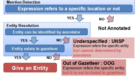
Men$on Detec$on (MD)
En$ty Resolu$on (ER)
Figure 2: Flow of our annotation scheme
sues discussed in Section 3. 4.1 Annotation
In the existing named entity tagged corpora in Japanese, expressions are annotated with a named entity class and its boundaries. However, the cor-pora does not contain annotations as to whether each of the expressions actually relates to an entity. Partly following the annotation guidelines in TAC KBP (Ji et al., 2014)2, the extended named entity tag
set (Sekine et al., 2002) and the Japanese extended Named Entity-tagged corpus, we followed the ap-proach illustrated in Figure 2 to annotate microblog texts. The annotation task consists of the following two subtasks:
Mention Detection (MD) Given a microblog text (i.e., a tweet), an annotator annotates all the mentions which refer to specific geographic en-tities with a predefined set of tags given in Ta-ble 1.
Entity Resolution (ER) For each detected men-tion, an annotator searches the gazetteer for its referred entity and annotates the linking. We al-low a mention to be linked to multiple gazetteer entries. If the referent cannot be found in the gazetteer, annotate the mention asOOG, and if the referent is not identifiable, annotate the mention asUNSP.
2http://nlp.cs.rpi.edu/kbp/2014/elquery.
Entity can be identified by annotator
YES NO
Not Annotated Entity Resolution
Expression refers to a specific location or not
YES
Give an Entity
NO
Underspecified : UNSP Expression refers the specific entity but cannot determined by annotator
Out of Gazetteer : OOG
Expression refers the specific entity
but it is not included in gazetteer Entity exists in gazetteer
NO YES
[image:4.612.312.543.66.196.2]Mention Detection
Figure 3: Description of OOG and UNSP tag
In our annotation, all potential LREs in the text are annotated. Following (Mani et al., 2010), non-referring expressions,such as “town” and “city” in “It is better to live in a small town than in a big city”, are not annotated. Deictic references such as “there” and pronouns are not annotated. The annotators are allowed to use the information from the writer’s pro-file for reference purposes.
4.2 Gazetteer
In Japan, under open data initiatives, government agencies have released data with the specific lat-itude and longlat-itude for the name to be used as a postal address, such as the prefecture and city (City-block level location reference information3).
Therefore, this can be used as the location name gazetteer. However, for facility entities, there is no existing comprehensive database. We used data crawled from Yahoo! Loco4, which is one of the
Location Based Social Networking Services (LB-SNSs). This is a large, but noisy, amount of data, which contains many duplicate records of the en-tity and surface variations. Therefore, we cleaned up entries that were ambiguous or those of which the name was either too short or too long by using several handwritten rules. In addition, we used en-tities downloaded from “National Land Numerical Information” for railroad data. Table 2 presents an overview of the resulting entity gazetteer. The Loca-tion entity gazetteer includes prefectures, cities, and other administrative areas such as “oaza” (sections) and villages. The Facility entity gazetteer includes a
Table 1: Definition of the tags used in our annotation
Tag Example Description
LOC(Location) 埼玉県/ Saitama-prefecture,仙台市/ Sendai-city Specific geographical area
FAC(Facility) 仙 台 駅 / Sendai-station, 九 州 大 学 / Kyusyuu University,
南 武 線/ Nanbu-line,東 北 道/ Tohoku-expressway
[image:5.612.105.500.180.219.2]Facility/Road/Railroad entity that has a specific location
Table 2: Overview of entity gazetteer used in our annotation
Gazetteer Type Source Number of Entries
Locations City-block level location reference information 147774
Facilities Yahoo! Loco, National Land Numerical Information 4990239
broad variety of facilities including stations, restau-rants, shopping stores, hospitals, and schools. As a result, we compiled a large (more than 5 million entries) gazetteer of location and facility entities in Japan.
Each entity is formatted as GeoJSON Feature ob-ject5, as this format is easy to use with other GIS
applications.
4.3 Two Sub-corpora for Annotation
We performed annotations for 10,000 randomly sampled tweets that were tweeted during a specific time period (RANDOM), but this proved problem-atic for refining the annotation scheme rapidly. Be-cause randomly sampled tweets very rarely contain an LRE, the yield ratio of entities is low and in-efficient. Therefore, we performed annotations for another 1,000 tweets (FIL), which were filtered ac-cording to the following rules: (1) Tweets must in-clude two or more potential location names that can be verified by peforming a simple string matching to the location entity gazetteer. (2) One of the location names of rule (1) must be the location name of a pre-fecture in which the annotator resides. These filters increase the LRE density, and enable us to rapidly advance the discussion to the annotation guideline. In a later section, we discuss the inter-annotator agreement in the FIL sub-corpus.
4.4 Tool for Corpus Annotation
Compared with mention detection, entity resolution tends to be considerably more expensive particu-larly when the gazetteer at hand has a large
cover-5http://geojson.org/
age. For a given geographical mention, the gazetteer may have dozens of candidate entries, from which the annotator would have to select the correct one. The tasks of searching for the candidate entries and choosing the most appropriate one from among them can be substantially supported with an ade-quate computational environment. For this purpose, we created an annotation support tool especially signed for our annotation schema. Unlike tools de-vised in prior work (Leidner, 2007), our tool stores the entire data of our gazetteer (including, for ex-ample, the postal address, ontological category, etc., for each facility entity) on a standard full-text search engine and allows the use to search for candidate en-tries with an arbitrary query string, as illustrated in Figure 5.
This tool works as a Web application, and is ca-pable of working with more than one person at the same time. Figure 4 shows an example of the anno-tated data, in which the annoanno-tated entities are rep-resented by the list of GeoJSON objects, and each object has an ID that uniquely corresponds to an en-tity in the gazetteer.
5 Corpus Annotation and Evaluation Using the annotation tools mentioned in the section 4, we annotated 10,000 tweets randomly selected from tweets sent during 2014. Table 3 shows the number of tagged expressions in the annotated cor-pus.
Interac(on with Gaze0eer Show Tweets
①Select the String with Mouse ②Search an En(ty from DB with Query ③Give NE Tag with Bu0on
[image:6.612.101.513.67.298.2]I’m depar*ng from Shinjuku in the Chuo Line
Figure 5: Screenshot of annotation tool
Tag of En)ty Annotated Expression (surface and its offset)
GeoJSON Object Coordinate of En)ty
Metadata of En)ty (ID in GazeEeer, addresses)
{
“selec)on”: “川崎駅", "start": 1, "end": 3,
“wholetext”: “川崎から南武線で立川へ", "tex)d": "326",
")me": 1419053994, "en)tyClass": ”FACILITY", "en))es": [ {
"type": "Feature", "geometry": { "type": "Point",
"coordinates": [139.697,35.530] },
"proper)es": { "surface": "川崎駅", "altnames": ["川崎駅"], “address”: “川崎区駅前本町", “code": “loco:3180795edf89”, } }
] }
Kawasaki-‐Sta)on
Kawasaki-‐Sta)on
I’ll go to Tachikawa from Kawasaki inNanbu-‐line
Figure 4: Example of annotated data
951 (54.6%) LREs were annotated with entities. As we analyzed instances without entities, we made the following observations.
Location These instances mainly suffer from an ab-sence of foreign location names, consisting of surrounding areas such as “Higashi Mikawa”, and tourist resorts such as “Mount Zao”.
Facility In most cases, highly ambiguous instances, such as “house”, “McDonald’s”, and
“work-place”, were difficult to annotate with an entity. As these instances are dependent on the context of the writer, a third person would be unable to guess the specific entity despite considering the whole text.
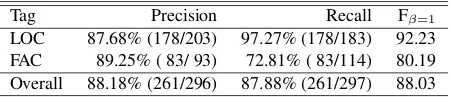
5.1 Quality of Annotation: Mention Detection To discuss the annotation specification, two annota-tors independently annotated 200 tweets.
First, two annotations were converted into IOB2 codings at the character level, and assuming that the annotation on one side is correct, we then calculated the precision, recall, and the F1-Score of the annota-tion on the other side. For reference, comparing two annotations at the character level, Cohen’s Kappa was 0.892. Table 4 shows the evaluation results of the inter-annotator agreement. This indicated that the annotation is generally successful, but the anno-tation quality of the FAC tag is slightly lower. As mentioned above, in this annotation, annotators need to interpret the intent of the writer of a text (irrespec-tive of whether a specific location is assumed).
(4) これでもう 大学図書館 から取り寄せてもら
わなくていいのね… / I don’t need to order
[image:6.612.92.283.356.514.2]Table 3: Number of tagged expressions in annotated corpus
Tag #tagged expression #tagged with entity OOG UNSP
LOC 406 298 (73.4%) 14 (3.4%) 94 (23.2%)
FAC 545 221 (40.6%) 43 (7.9%) 281 (51.6%)
TOTAL 951 519 (54.6%) 57 (6.0%) 375 (39.4%)
#Tweet 10000
#Character 332739
Table 4: Evaluation results of inter-annotator agreement (assuming the annotation on one side is correct)
Tag Precision Recall Fβ=1
LOC 87.68% (178/203) 97.27% (178/183) 92.23 FAC 89.25% ( 83/ 93) 72.81% ( 83/114) 80.19 Overall 88.18% (261/296) 87.88% (261/297) 88.03
In this example, one annotator judged “univer-sity library” as a facility name, on the other hand, the other judged it as an organization and did not annotate it as an LRE. This arrangement probably makes annotation harder; hence, we would have to re-examine this guideline for future work.
5.2 Quality of Annotation: Entity Resolution To evaluate our entity resolution annotation scheme quantitatively, we compare the coordinate pair of the entity that was annotated by two annotators, as de-scribed in the section 5.1. As error metrics, we use the Average Error Distance (AED) and Median Er-ror Distance (MED) to ensure comparability with re-lated work. Each of the two annotators annotated 243 expressions, and the AED was determined as 1648 meters, whereas the MED was found to be 0 meters. Of these 243 instances, 199 (81.9%) show an error distance of 0 meters. In other words, two an-notators annotated exactly the same entity for these instances. The following example shows instances with large errors in the distance. This instance indi-cates that the two annotators made different interpre-tations, and thus the annotations differed. We denote the annotators as A and B.
(5) (Error Distance: 70.8 km) 江坂周辺、[淡 路 A:LOC/兵 庫 県 淡 路 市 B:FAC/淡 路 駅 (大 阪 市 東 淀 川
区)] 周辺、西中島南方周辺、新大阪周辺で
バイト見つけたい / I want to work in a
part-time job near Esaka, [Awaji A:LOC/Awaji-shi, Hyogo B:FAC/Awaji Station(Yodogawa-ku, Osaka-shi)],
Nishi-Nakajima, or Shin-Osaka.
According to the two annotators, one annotator interpreted each location name in this example lit-erally and confirmed that these location names be-long to “Kansai region”, then annotated “Awaji-shi”, which has the largest population. The other annota-tor perceived that these location names are station names in a specific region, then interpreted “Awaji” as a station name in “Osaka-shi”. We plan to dis-cuss how much reasoning or background knowledge should be used for annotation.
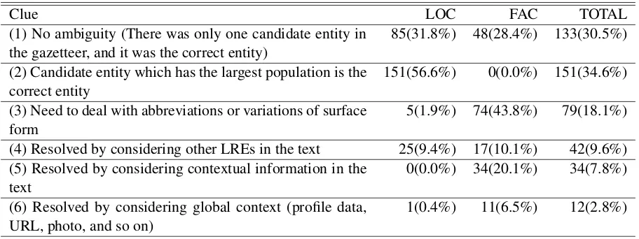
5.3 Required Clues for Entity Resolution As we show below, although some LREs need com-plex reasoning and annotations for them disagree, on the other hand, there are also LREs which are easily annotated by a simple clue. We investigated the annotated entities of 10,000 tweets in RAN-DOM, judged what types of clues are required for manual entity resolution, and examined the distribu-tion. When we performed manual judgement, we assumed that the LRE tag (location or facility name) and the boundary is given, and then we focused on the types of clues required for entity resolution, which can require multiple clues. In addition, LREs annotated with a single entity are subject to investi-gation. Therefore, 267 location names and 169 fa-cility names were investigated. Table 5 shows the result. This table enables us to make the following observations.
[image:7.612.74.299.232.281.2]Table 5: Required Clues for entity resolution
Clue LOC FAC TOTAL
(1) No ambiguity (There was only one candidate entity in
the gazetteer, and it was the correct entity) 85(31.8%) 48(28.4%) 133(30.5%) (2) Candidate entity which has the largest population is the
correct entity 151(56.6%) 0(0.0%) 151(34.6%)
(3) Need to deal with abbreviations or variations of surface
form 5(1.9%) 74(43.8%) 79(18.1%)
(4) Resolved by considering other LREs in the text 25(9.4%) 17(10.1%) 42(9.6%) (5) Resolved by considering contextual information in the
text 0(0.0%) 34(20.1%) 34(7.8%)
(6) Resolved by considering global context (profile data,
URL, photo, and so on) 1(0.4%) 11(6.5%) 12(2.8%)
result is consistent with those of (Leidner, 2007), which targeted the newspaper domain.
However, in the case of facility names, entity res-olution was more complicated. Although the pro-portion considered to be unambiguous is virtually the same as that of the location names, there are no existing metrics, such as population, for facility en-tities. Therefore, defining metrics, such as popula-tion, is desirable. For that purpose, we would prefer to consider a term such as “popularity”. To calcu-late these metrics, the check-in counts of a Location Based Social Network Service (LBSNSs), such as Foursquare6or Loctouch7, appear to be useful.
In addition, 40% of facility names require the ability to process abbreviations and variations of sur-face forms. For example, “Hama-sta” in the fol-lowing text seems to refer to “Yokohama Stadium”; however, it is not possible to look this up directly in the facility entity gazetteer.
(6) ハマスタ で試合観戦なう / I’m watching a
game at Hama-sta.
To address this, we would have to consult the gazetteer flexibly, by using methods such as approx-imate string matching (Okazaki and Tsujii, 2010). As this is a widespread problem with facility names, it would have to be addressed to enable grounding to be performed.
6https://foursquare.com/ 7http://tou.ch/
Moreover, 20% of facility names required local context in the text (other than LRE). The following is an example.
(7) 山手線で 東京 から品川に向かっています/
I’m going toward Shinagawa From Tokyo.
In this example, “Tokyo” seems to refer to “Tokyo Station”, considering the local context in the text. As far as we searched, most of the entities requir-ing local context were station names such as “Tokyo Station”.
6 Conclusion
This paper discusses the problems associated with the task of annotating geographical entities on Japanese microblog texts and reports the preliminary results of the actual annotation. All the annotation data and the annotation guidelines are publicly avail-able for research purposes from our web site.
The annotation task consisted of two subtasks: mention detection and entity resolution. Our cor-pus study showed that our annotation scheme could achieve a reasonably high inter-annotator agree-ment.
The scope of the annotation was extended to facil-ity entities by introducing theOOGandUNSPtags. The distributions of these tags obtained through our corpus study will provide useful implications for our future work for an improved annotation setting.
that the task of identifying facility entities poses interesting research issues including abbreviations, variations of surface forms, and the popularity of each facility. In particular, the popularity appears to be important in resolving facility entities. The auto-matic estimation of the popularity over a broad range of facilities may present an interesting research is-sue.
Acknowledgments
This research was supported by the program Re-search and Development on Real World Big Data Integration and Analysis of the Ministry of Educa-tion, Culture, Sports, Science and Technology, Japan and by the Precursory Research for Embryonic Sci-ence and Technology (PRESTO), Japan SciSci-ence and Technology Agency (JST).
References
Nigel Collier. 2012. Uncovering text mining: A sur-vey of current work on web-based epidemic
intelli-gence. Global Public Health, 7(7):731–749. PMID:
22783909.
Grant DeLozier, Jason Baldridge, and Loretta London. 2015. Gazetteer-independent toponym resolution
us-ing geographic word profiles. InProceedings of AAAI
2015. The AAAI Press.
Heng Ji, HT Dang, J Nothman, and B Hachey. 2014. Overview of tac-kbp2014 entity discovery and linking
tasks.Proc. Text Analysis Conference (TAC2014).
Asanobu Kitamoto and Takeshi Sagara. 2012. Toponym-based geotagging for observing precipitation from so-cial and scientific data streams. In Gerald Friedland
Liangliang Cao, editor,Proceedings of the 2012 ACM
Workshop on Geotagging and Its Applications in Mul-timedia, GeoMM’12 (co-located with ACM Multime-dia 2012), pages 23–26. ACM, 11.
Jochen L. Leidner. 2007. Toponym resolution in
text: Annotation, evaluation and applications of spatial
grounding. SIGIR Forum, 41(2):124–126, December.
Jiwei Li, Alan Ritter, and Eduard Hovy. 2014. Weakly
supervised user profile extraction from twitter. In
Pro-ceedings of the 52nd Annual Meeting of the Associa-tion for ComputaAssocia-tional Linguistics (Volume 1: Long Papers), pages 165–174. Association for Computa-tional Linguistics.
Michael D. Lieberman, Hanan Samet, and Jagan Sankaranarayanan. 2010. Geotagging with local lex-icons to build indexes for textually-specified spatial data. In Feifei Li, Mirella M. Moro, Shahram Ghan-deharizadeh, Jayant R. Haritsa, Gerhard Weikum,
Michael J. Carey, Fabio Casati, Edward Y. Chang, Ioana Manolescu, Sharad Mehrotra, Umeshwar Dayal,
and Vassilis J. Tsotras, editors,ICDE, pages 201–212.
IEEE.
Inderjeet Mani, Christy Doran, Dave Harris, Janet Hitze-man, Rob Quimby, Justin Richer, Ben Wellner, Scott Mardis, and Seamus Clancy. 2010. Spatialml:
anno-tation scheme, resources, and evaluation. Language
Resources and Evaluation, 44(3):263–280.
S.E. Middleton, L. Middleton, and S. Modafferi. 2014. Real-time crisis mapping of natural disasters using
so-cial media. Intelligent Systems, IEEE, 29(2):9–17,
Mar.
Kiyonori Ohtake, Jun Goto, Stijn De Saeger, Kentaro Torisawa, Junta Mizuno, and Kentaro Inui. 2013. Nict
disaster information analysis system. InThe
Compan-ion Volume of the Proceedings of IJCNLP 2013: Sys-tem Demonstrations, pages 29–32. Asian Federation of Natural Language Processing.
Naoaki Okazaki and Jun’ichi Tsujii. 2010. Simple and efficient algorithm for approximate dictionary
match-ing. In Proceedings of the 23rd International
Con-ference on Computational Linguistics, COLING ’10, pages 851–859, Stroudsburg, PA, USA. Association for Computational Linguistics.
Wim Peters and Ivonne Peters. 2000. Lexicalised
sys-tematic polysemy in wordnet. In Proceedings of the
Second International Conference on Language Re-sources and Evaluation (LREC’00). European Lan-guage Resources Association (ELRA).
Axel Schulz, Aristotelis Hadjakos, Heiko Paulheim, Jo-hannes Nachtwey, and Max Mhlhuser. 2013. A multi-indicator approach for geolocalization of tweets. In Emre Kiciman, Nicole B. Ellison, Bernie Hogan,
Paul Resnick, and Ian Soboroff, editors,ICWSM. The
AAAI Press.
Satoshi Sekine, Kiyoshi Sudo, and Chikashi Nobata.
2002. Extended named entity hierarchy. In
Proceed-ings of the Third International Conference on Lan-guage Resources and Evaluation (LREC-2002), Las Palmas, Canary Islands - Spain, May. European Lan-guage Resources Association (ELRA).
Alessio Signorini, Alberto Maria Segre, and Philip M. Polgreen. 2011. The use of twitter to track lev-els of disease activity and public concern in the u.s.
during the influenza a h1n1 pandemic. PLoS ONE,
6(5):e19467, 05.
Istv´an Varga, Motoki Sano, Kentaro Torisawa, Chikara Hashimoto, Kiyonori Ohtake, Takao Kawai, Jong-Hoon Oh, and Stijn De Saeger. 2013. Aid is out there: Looking for help from tweets during a large
scale disaster. InProceedings of the 51st Annual
Meet-ing of the Association for Computational LMeet-inguistics (Volume 1: Long Papers), pages 1619–1629. Associa-tion for ComputaAssocia-tional Linguistics.
Wei Zhang and Judith Gelernter. 2014. Geocoding location expressions in twitter messages: A
prefer-ence learning method. J. Spatial Information Science,