Prepared for: County of Orange Orange County Parks
Planning and Design Division 13042 Old Myford Road Irvine, California 92602
Prepared by:
Stantec Consulting Services Inc. 290 Conejo Ridge Avenue Thousand Oaks, California 91361
ABBREVIATIONS ... III 1.0 INTRODUCTION ... 1.1
1.1 OVERVIEW ... 1.1 1.2 AGENCIES INVOLVED AND PERMIT, CONSULTATION, AND ENVIRONMENTAL
REVIEW REQUIREMENTS ... 1.1 1.3 PROJECT TITLE ... 1.3 1.4 LEAD AGENCY AND PROJECT PROPONENT ... 1.3 1.5 INTENDED USES OF THE INITIAL STUDY/MITIGATED NEGATIVE DECLARATION ... 1.4 1.6 INCORPORATION BY REFERENCE ... 1.4
2.0 PROJECT DESCRIPTION ... 2.1
2.1 PROJECT BACKGROUND ... 2.1 2.2 PROJECT ELEMENTS ... 2.1 2.3 GRADING AND DRAINAGE PLAN SUMMARY ... 2.2 2.4 CITY OF FULLERTON PLAN LAND USE DESIGNATION ... 2.3 2.5 CITY OF FULLERTON ZONING ... 2.3 2.6 SURROUNDING USES ... 2.3
3.0 EVALUATION OF ENVIRONMENTAL IMPACTS ... 3.1
3.1 AESTHETICS ... 3.1 3.2 AGRICULTURE AND FORESTRY RESOURCES ... 3.5 3.3 AIR QUALITY ... 3.7 3.4 BIOLOGICAL RESOURCES ... 3.15 3.5 CULTURAL RESOURCES ... 3.26 3.6 GEOLOGY AND SOILS ... 3.29 3.7 GREENHOUSE GAS EMISSIONS ... 3.33 3.8 HAZARDS AND HAZARDOUS MATERIALS ... 3.35 3.9 HYDROLOGY AND WATER QUALITY ... 3.38 3.10 LAND USE AND PLANNING ... 3.44 3.11 MINERAL RESOURCES ... 3.46 3.12 NOISE ... 3.47 3.13 POPULATION AND HOUSING ... 3.51 3.14 PUBLIC SERVICES ... 3.52 3.15 RECREATION ... 3.54 3.16 TRANSPORTATION AND TRAFFIC ... 3.55 3.17 TRIBAL CULTURAL RESOURCES ... 3.58 3.18 UTILITIES AND SERVICE SYSTEMS ... 3.60 3.19 MANDATORY FINDINGS OF SIGNIFICANCE ... 3.64
LIST OF TABLES
Table 1 Agency Permits and Environmental Review Requirements ... 1.2 Table 2 Site Excavation and Disturbance Estimates ... 2.2 Table 3 Attainment Status of South Coast Air Basin ... 3.8 Table 4 SCAQMD Air Quality Significance Thresholds (Mass Daily Thresholds) ... 3.10 Table 5 Unmitigated Project Construction Emissions in Comparison to SCAQMD
Significance Criteria ... 3.11 Table 6 Unmitigated Project Operation Emissions in Comparison to SCAQMD
Significance Criteria ... 3.11 Table 7 Mitigated Project PM10 and PM2.5 Construction Emissions in Comparison to
SCAQMD Significance Criteria ... 3.12
LIST OF FIGURES
Figure 1 Project Location ... 2.4 Figure 2 Preliminary Site Plan ... 2.5 Figure 3 Scenic Corridors within the City of Fullerton ... 3.3
LIST OF APPENDICES
PROJECT EMISSIONS ESTIMATES ... A.1 BIOLOGICAL RESOURCES TECHNICAL REPORT ... B.1 CULTURAL RESOURCES SURVEY REPORT... C.1 PRELIMINARY GRADING AND DRAINAGE PLAN ... D.1
AB 939 ADA
Assembly Bill 939: State of California Waste Management Plan Americans with Disabilities Act
AQMP Air Quality Management Plan
CAP Climate Action Plan
CDFW California Department of Fish and Wildlife CH4 Methane
CNEL Community Noise Exposure Level
CO Carbon Monoxide
CO2 Carbon Dioxide
CO2e Carbon Dioxide Equivalent
DBH Diameter at Breast Height
DAMP Drainage Area Management Plan
FMC Fullerton Municipal Code
GHG Greenhouse Gas
H2S Hydrogen Sulfide
IMBA International Mountain Bicycling Association
MEP Maximum Extent Practicable
MRF Material Recovery Facility
MWD Metropolitan Water District of Southern California
NO2 Nitrogen Dioxide
N2O Nitrous Oxide
NPDES National Pollutant Discharge Elimination System
OC Parks Orange County Parks
O3 Ozone Pb Lead
PM10 Particulate Matter of 10 Microns in diameter or smaller PM2.5 Particulate Matter of 2.5 Microns in diameter or smaller
Project Craig Park Bike Facility
SCAQMD South Coast Air Quality Management District
SO2 Sulfur Dioxide
SWPPP Stormwater Pollution Prevention Plan
SWRCB State Water Resources Control Board
USACE US Army Corps of Engineers
UWMP Urban Water Management Plan
1.0
INTRODUCTION
1.1
OVERVIEW
Orange County Parks (OC Parks) is planning to construct, operate, and maintain the Craig Park Bike Facility (Project), a 9.7-acre mountain bike skills course facility for all ages and abilities. The proposed Project is located within Craig Regional Park in the City of Fullerton, California. The Project site is on land owned by the U.S. Army Corps of Engineers (USACE) in relation to the operation of adjacent Fullerton Dam which is used for flood control purposes. The land is also leased from the USACE by OC Parks for recreation purposes in association with the operation and maintenance of Craig Regional Park.
1.2
AGENCIES INVOLVED AND PERMIT, CONSULTATION, AND
ENVIRONMENTAL REVIEW REQUIREMENTS
The public agency that has the principal responsibility for carrying out or approving a project is designated as the “Lead Agency” under California Environmental Quality Act (CEQA). The County of Orange is the Lead Agency responsible for preparation of this Initial Study/Mitigated Negative Declaration and therefore has the principal responsibility for approving and
implementing the Project.
This Initial Study/Mitigated Negative Declaration is intended to be used as the CEQA document for all local and state approvals required for the Project; including approvals by responsible agencies, and any approvals required from trustee agencies. “Responsible Agency” means a public agency that proposes to carry out or approve a project for which the Lead Agency is preparing the CEQA document for. For purposes of CEQA, the term “Responsible Agency” includes all public agencies other than the Lead Agency having discretionary approval authority over the Project. “Trustee Agency” means a State agency having jurisdiction by law over project-affected natural resources that are held in trust for the people of the State of California.
Responsible agencies that may have discretionary approval authority over the Project, and trustee agencies having jurisdiction over natural resources affected by the Project which are held in trust for the people of the State of California, will have the opportunity to review and provide comments during the review period. Other agencies and the public may also provide comments.
The Project is located on lands owned by the USACE that are leased to the County of Orange for operation and maintenance of Craig Regional Park. As a result, the City of Fullerton
federally owned lands. However, the City of Fullerton will have the opportunity to review and comment on the Draft Initial Study/Mitigated Negative Declaration. The Project requires approval from the USACE in the form of a Lease Agreement Consistency Determination or Modification.
The agencies involved, and permit, consultation, and environmental review requirements are summarized below in Table 1.
Table 1 Agency Permits and Environmental Review Requirements
Agency Permits and Other Approvals Environmental Review/Consultation Requirements
FEDERAL
U.S. Army Corps of
Engineers • Lease Agreement Consistency Determination or Modification • Federal Lead Agency responsible for National Environmental Policy Act compliance and coordinating Federal Endangered Species Act consultation
U.S. Fish and Wildlife
Service • Consultation with U.S. Army Corps of Engineers • Federal Endangered Species Act Section 7 Consultation with U.S. Army Corps of Engineers
STATE
California Department
of Fish and Wildfire • Streambed Alteration Agreement if final Project design indicates alteration of jurisdictional streambed or bank
• Trustee Agency, review and comment on Draft Initial Study/Mitigated Negative Declaration
• Also becomes Responsible Agency through issuance of Streambed Alteration Agreement if final Project design and implementation would not avoid impacts to bed and bank of Waters of the State.
State of California Santa Ana Regional Water Quality Control Board (Region 8)
• General Permits for Stormwater Discharges Associated with Construction and Land Disturbance Activities & Municipal Sewer Discharges
• Stormwater Pollution
Prevention Plan approval and discharge compliance oversight
• issuance of U.S. Clean Water Act Section 401 Water Quality Certification or Waste
Discharge Requirements if final Project design and
implementation would not avoid discharge of dredge of fill materials to Waters of the U.S. and/or State.
• Responsible Agency if Clean Water Act Section 401 Water Quality Certification or Waste Discharge Requirements apply.
• Review and comment on Draft Initial Study/Mitigated Negative Declaration
Agency Permits and Other Approvals Environmental Review/Consultation Requirements
LOCAL
County of Orange • Issuance of building and grading permits.
• Review and approval of Water Quality Management Plan.
• CEQA Lead Agency responsible for preparing, noticing, and adopting the Initial Study/Mitigated Negative Declaration
City of Fullerton • None1 • Advisory Agency, review and comment on Draft Initial Study/Mitigated Negative Declaration OTHER Soboba Band of Luiseño Indians, Juaneño Band of Mission Indians, San Gabriel Band of Mission Indians, and
Gabrieleño Band of Mission Indians
• None • Notification and invitation to consult in compliance with AB 52
• Review and comment on Draft Initial Study/Mitigated Negative Declaration
1.3
PROJECT TITLE
Craig Park Bike Facility
1.4
LEAD AGENCY AND PROJECT PROPONENT
OC Parks | Planning & Design Division 13042 Old Myford Road
Irvine, California 92602
1.5
INTENDED USES OF THE INITIAL STUDY/MITIGATED NEGATIVE
DECLARATION
This Initial Study/Mitigated Negative Declaration is an informational document intended to inform the lead agency, other responsible or interested agencies and the public of potential environmental effects of the Project. The environmental review process has been established to enable public agencies to evaluate potential environmental consequences and to examine and implement methods of eliminating or reducing any potential significant adverse impact below a level of significance.
1.6
INCORPORATION BY REFERENCE
CEQA Guidelines §15150 provides for incorporating other documents into the Mitigated Negative Declaration by reference. When a document is incorporated by reference, the incorporated document is considered to be part of the Mitigated Negative Declaration. Incorporation by reference rather than repeating the entire incorporated text allows the Mitigated Negative Declaration to focus on the environmental consequences and still
incorporate necessary technical and auxiliary information without becoming an extremely long document.
Incorporated by reference are the City of Fullerton General Plan (also known and used throughout the remainder of this Initial Study/Mitigated Negative Declaration as the “Fullerton Plan”) and the Fullerton Plan Environmental Impact Report.
Documents incorporated by reference are made available for public review at the same time and place(s) that this Initial Study/Mitigated Negative Declaration is available for review. Incorporation by reference allows those public decision-makers and interested public to review technical material that is summarized in the Initial Study/Mitigated Negative Declaration without needlessly and substantially lengthening the Initial Study/Mitigated Negative Declaration itself with this material.
2.0
PROJECT DESCRIPTION
2.1
PROJECT BACKGROUND
The Craig Park Bike Facility design-development phase was funded by OC Parks and the International Mountain Bicycling Association (IMBA) Bike Park Initiative Grant. The Bike Park Initiative Grant is an IMBA-led project designed to foster the development of world-class bike park facilities across the country. In early 2014, OC Parks initiated a study with the IMBA Trail Solutions program to determine the feasibility of hosting a bike park facility in Orange County and to explore creating a bike facility within OC Parks. Several existing County regional park locations were considered. Craig Regional Park was selected as the most feasible due to the site location, size, topography, and proximity to existing amenities. The Project proposes to create a non-motorized bike facility for all ages, abilities, and skill levels. Two public workshops were held in January and March of 2015, to present design concepts and proposed bike facility features for public feedback toward finalizing a design-development plan, signage guidelines, and project report. Increased public input and participation demonstrated the demand, desire, and interest of the City of Fullerton to foster success for the Craig Park Bike Facility.
2.2
PROJECT ELEMENTS
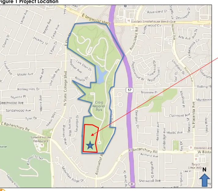
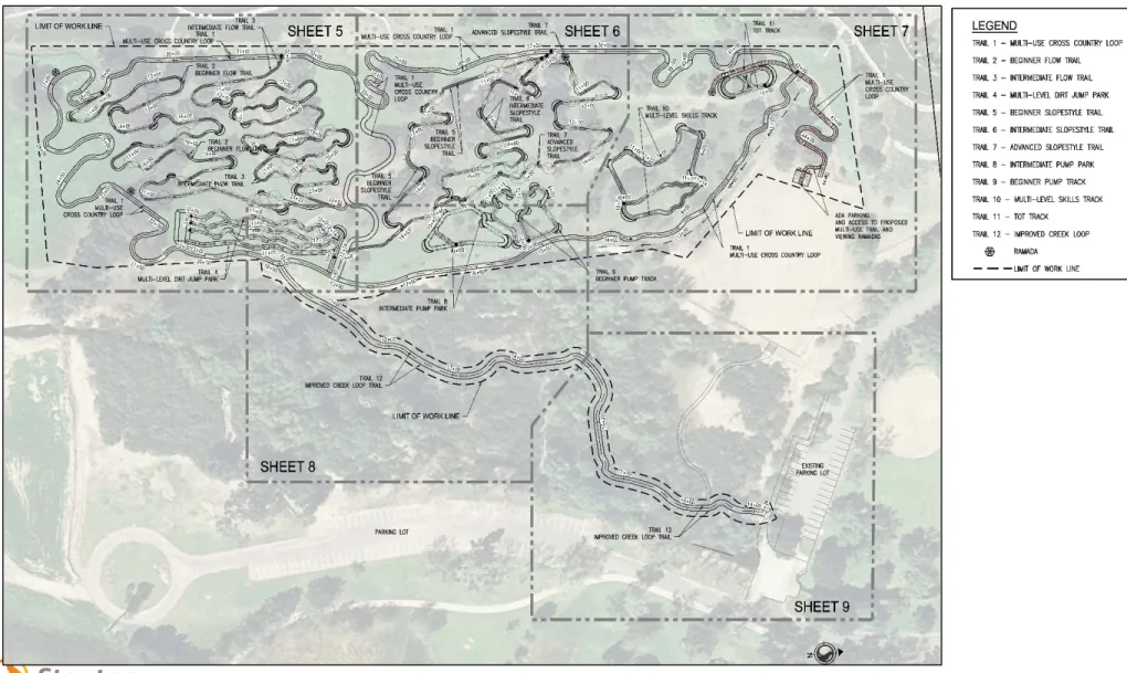
The proposed Project is within the Craig Regional Park in Fullerton, California. The 124-acre Park is owned by USACE, and is managed and operated by OC Parks through a lease agreement with USACE. The Project site is proposed to be situated on approximately 9.7 acres of the 124-acre Craig Regional Park near Associated Road and East Bastanchury Road (see Figures 1 and 2). Adjacent to the Project area, is Fullerton Dam to the south, residential housing to the west, and park facilities to the north and east. The Park encompasses 124-acres of open space, one lake, three creeks, a rose garden, trails, and recreational sport areas. The proposed Project site, is largely hillside with an approximate average 12 percent grade from west to east and an average 3 percent grade north to south. While the Project site is largely in an undeveloped portion of Craig Regional Park, a number of user-created footpaths currently pass through the site, in addition to two graded service routes that traverse the site from the north to south.
1. The Project would be implemented within the existing hillside area that encompasses approximately 9.7 acres of the 124-acre Craig Regional Park. The Project would include a variety of newly constructed trail features and difficulty types, including beginner and intermediate pump tracks3, beginner to advanced dirt jump areas, slope style courses, an improved creek loop trail, and a multi-use cross country loop (see Figures 1 and 2). The trail widths would range from 36 to 96 inches and have a maximum slope of 15
percent. The slope average would be 1 to 5 percent for beginner tracks and 5 to 7 percent for intermediate and advanced tracks. The trail lengths would range from 215 feet in length for the dirt jump areas, to 3,774 feet for the multi-use cross country loop. There are five ramada4 areas with picnic tables proposed within the Project to provide shade and rest areas for bike facility users. Project design would be in accordance with the 2010
American with Disabilities Act (ADA) Standards for ADA use. In addition to providing ADA
parking, the Multi-Use Cross Country Loop (Trail 1) leading to the viewing ramada located near the Tot Track5 (Trail 11) within the southern end of the Project area would be ADA accessible. Signage, including ADA signage and striping (where necessary) would be installed to provide guidance and direction to bike facility users throughout the Project area. A weather resistant bulletin board/map kiosk would be installed at the entry of the Project illustrating the map, legend, and bulletin information of trail difficulty for bike facility users. In addition, trailhead posts would be placed throughout the Project cautioning steep hills, identifying trail names, and trail information. A storm water catch basin and bioswales/filtration system would also be installed as part of the Project.
2.3
GRADING AND DRAINAGE PLAN SUMMARY
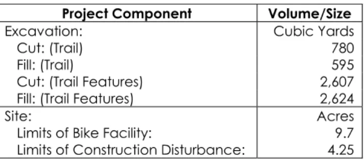
Based on 30% Grading and Drainage Plan (Appendix D), Table 2 below table summarizes the limits of construction disturbance and cut and fill for the Project.
Table 2 Site Excavation and Disturbance Estimates
Project Component Volume/Size
Excavation: Cubic Yards
Cut: (Trail) 780
Fill: (Trail) 595
Cut: (Trail Features) 2,607 Fill: (Trail Features) 2,624 Site:
Limits of Bike Facility:
Limits of Construction Disturbance:
Acres 9.7 4.25
The grading was designed to minimize excavation by creating a cut and fill balance along each of the bike trail alignments, while meeting maximum allowable grades. Side slopes were designed in the direction of the existing topography to maintain drainage patterns. Low points in the trail would be protected from erosion through the placement of rock that makes underlying soils less subject to potential erosion. Areas where offsite flows enter the Project and cross a trail would be dispersed with a rock rip rap pad upstream and downstream from the trail. The rip rap
4 A ramada is a roofed, open-sided structure providing shade and protection from outdoor elements, designed especially to provide shade.
5 A Tot Track is a pumptrack designed for smaller bicycles and users. It will feature reduced-sized rollers and swales as well as lower-angle bermed turns.
pad acts as an energy dissipater and helps protect the area from erosion. The Project’s on-site catch basin and bioswales/filtration system would allow for storm water drainage to be
captured and filtered before entering the storm drain system.
2.4
CITY OF FULLERTON PLAN LAND USE DESIGNATION
P-R (Parks and Recreation)
2.5
CITY OF FULLERTON ZONING
P-L (Public Lands)
2.6
SURROUNDING USES
The surrounding uses are described below:
• North: State Route 90 (SR-90) Imperial Highway, existing single-family homes and State Route 57 (SR-57) Freeway.
• East: Associated Road, existing apartments and multi-family homes, and SR-57 Freeway.
• South: Fullerton Dam, East Bastanchury Road, existing single-family and multi-family homes.
• West: State College Boulevard, existing single-family homes.
Figure 1 below illustrates the Project location and the approximate Project boundary of the proposed bike facility. Figure 2 below presents the preliminary site plan for the Project.
Figure 1 Project Location
Legend
124-Acre Craig Regional Park
Proposed Bike Facility Reflects approximate 9.7-acre Project Boundary
3.0
EVALUATION OF ENVIRONMENTAL IMPACTS
3.1
AESTHETICS
Issues Potentially Significant Impact Less Than Significant Impact with Mitigation Incorporated Less Than Significant Impact No ImpactAESTHETICS: Would the project:
a) Have a substantial adverse effect on a scenic vista?
b) Substantially damage scenic resources, including, but not limited to, trees, rock outcroppings, and historic buildings within a state scenic highway?
c) Substantially degrade the existing visual character or quality of the site and its surroundings?
d) Create a new source of substantial light or glare which would adversely affect day or nighttime views in the area?
a) Have a substantial adverse effect on a scenic vista?
No Impact. For purposes of determining significance under CEQA, a scenic vista is defined as a viewpoint that provides expansive views of a highly-valued landscape for the benefit of the general public. There are no designated scenic vistas located in proximity to the Project site that could be affected by Project implementation. Exhibit 10, Scenic Corridors, of the Fullerton Plan (City of Fullerton, 2012a) identifies Scenic Corridors within the City (Figure 3). These corridors are located along Harbor Boulevard, Euclid Street, Brea Boulevard, State College Boulevard, Rosecrans Avenue, and Bastanchury Road. The segments of State College Boulevard and Bastanchury Road are within the vicinity of the Project site and are occupied by parks, single-family homes, and multi-single-family homes. However, the Project site is not visible from State College Boulevard or Bastanchury Road. The Project would be constructed and operated at the
southwestern portion of Craig Regional Park in an area with substantial vegetative and tree cover that would largely remain after construction of the Project. Project grading has been designed to minimize excavation and alterations to existing topography. Project features such
as trails and drainage improvements are low-lying and close to the existing ground level. Placement of small signs would not extend in height above approximately six feet. The Project’s tallest features would be the five ramadas that have a maximum height of ten feet. Due to topography, the site is not being readily visible from public areas surrounding Craig Regional Park and the Project would not have the potential to substantially impair views of the park. The bike facility would result in limited topographic change to the site and a majority of the existing trees would be maintained. The site is further located adjacent to the Fullerton Dam in the southwestern corner of Craig Regional Park that is not visible from a majority of the remainder of the park to the north. Because of the Project’s design to minimize grading, maintain the existing trees, lack of new features with substantial height, and location within the park, the Project would not substantially impair existing views from within Craig Regional Park. The Project would have no impact on a scenic vista or City’s scenic corridor.
b) Substantially damage scenic resources, including, but not limited to, trees, rock outcroppings, and historic buildings within a state scenic highway?
No Impact. The Project is not located within a state scenic highway nor are any designated state scenic highways within the vicinity of the Project site according to the Fullerton Plan. The Project would have no impact on scenic resources, including, but not limited to, trees, rock outcroppings, and historic buildings within a state scenic highway.
c) Substantially degrade the existing visual character or quality of the site and its surroundings?
Less Than Significant Impact. The Project proposes to enhance existing Craig Regional Park with optimized bicycle trails that would be compatible with the existing and adjacent uses. While vehicles and construction equipment would be present at the Project site during construction of the facility, their presence would be short term and construction of the Project would be
completed within the allowable construction hours.
The existing park currently offers recreational uses such as bike trails and sport areas, in addition to trees, gardens, trails, and a lake. The approximately 9.7-acre area Project site within the park has an approximate average 12 percent grade from west to east and an average 3 percent grade north to south along the eastern boundary. The existing hillside consists of trees and sparse vegetation with grades that are suitable for development of a bike facility. Neighborhoods line the ridgeline above the western boundary of the proposed Project site and look down into the park. Trails would be constructed to minimize grading and to avoid removal of trees (only seven of well over 100 trees would be removed from the Project footprint). The Project site, while largely undeveloped, does have some existing trails and access roads that have resulted in a partially disturbed nature. The Project elements would remain consistent with the existing visual character and quality of the park and its surroundings and would have a less than significant impact.
d) Create a new source of substantial light or glare which would adversely affect day or
nighttime views in the area?
No lmpact. Operation of the bike facility would be consistent with park hours and would operate from 7 a.m. to 6 p.m. seven days a week. The Project would not utilize outdoor lighting for the optimized bicycle trails, and therefore, neighborhoods in the view shed of the Project site would not be exposed to an increase in outdoor night lighting. The Project would have no impact on the light environment visible from surrounding properties. Highly polished materials or highly reflective metal material and glass that could reflect light and create glare are not proposed. Proposed bike trails would be composed of engineered soil. Ramadas would be composed of concrete pillars within wooden arbors. The Project would not introduce any new sources of glare that are incompatible with the surrounding areas. The Project would not include any new
parking with lighting, nor any newly built structures in which the architectural materials would cause excessive glare. Therefore, the Project would not create a new source of substantial light
3.2
AGRICULTURE AND FORESTRY RESOURCES
Issues Potentially Significant Impact Less Than Significant Impact with Mitigation Incorporated Less Than Significant Impact No ImpactAGRICULTURE AND FORESTRY RESOURCES: Would the project: a) Convert Prime Farmland, Unique Farmland, or
Farmland of Statewide Importance (Farmland), as shown on the maps prepared pursuant to the Farmland Mapping and Monitoring Program of the California Resources Agency, to non-agricultural use? b) Conflict with existing zoning for agricultural
use, or a Williamson Act contract?
c) Conflict with existing zoning for, or cause rezoning of, forest land (as defined in Public Resources Code section 12220(g)), timberland (as defined by Public Resources Code section 4526, or timberland zoned Timberland Protection (as defined by Government Code section 51104(g))?
d) Result in the loss of forest land or conversion of forest land to non-forest use?
e) Involve other changes in the existing environment which, due to their location or nature, could result in conversion of farmland to non-agricultural use or conversion of forest land to non-forest use?
a) Convert Prime Farmland, Unique Farmland, or Farmland of Statewide Importance
(Farmland), as shown on the maps prepared pursuant to the Farmland Mapping and Monitoring Program of the California Resources Agency, to non-agricultural use?
No lmpact. The Project site is within the 124-acre existing Craig Regional Park and surrounded by urbanized development. According to the State of California’s Important Farmland Map 2014 for Orange County, the Project site is designated as “urban land,” which consists of urban development with a density of at least 1 unit to 1.5 acres or greater. The Project site does not contain Prime Farmland, Unique Farmland, or Farmland of Statewide Importance (California Department of Conservation, 2017). Consequently, the Project would not convert Farmland to a non-agricultural use. No impact would occur.
b) Conflict with existing zoning for agricultural use, or a Williamson Act contract?
No lmpact. Williamson Act contracts restrict land development of contract lands. The contracts typically limit land use in contract lands to agriculture, recreation, and open space, unless otherwise stated in the contract. The Project site is not in the Williamson Act Conservation Contract database and would not conflict with existing zoning for agricultural use.
c) Conflict with existing zoning for, or cause rezoning of, forest land (as defined in Public
Resources Code section 12220(g)), timberland (as defined by Public Resources Code section 4526 or timberland zoned Timberland Protection (as defined by Government Code section 51104(g))?
No lmpact. The Project site is not zoned as forest land or timberland and does not include any timberland resources. The Project would have no impacts on forest land or timberland.
d) Result in the loss of forest land or conversion of forest land to non-forest use?
No Impact. There is no forest land or any land that is designated to the conservation of forest land within the Project site. The Project would have no impact on forest land.
e) Involve other changes in the existing environment which, due to their location or nature,
could result in conversion of farmland to non-agricultural use or conversion of forest land to non-forest use?
No Impact. The Project is not located within proximity to any land zoned or utilized for farmland or forest land. The Project site is within an urbanized area of the City and would not result in the conversion of farmland to non-agricultural use or conversion of forest land to non-forest uses. No impact would occur.
3.3
AIR QUALITY
Issues Potentially Significant Impact Less Than Significant Impact with Mitigation Incorporated Less Than Significant Impact No ImpactAIR QUALITY: Would the project:
a) Conflict with or obstruct implementation of the applicable air quality plan?
b) Violate any air quality standard or contribute substantially to an existing or projected air quality violation?
c) Result in a cumulatively considerable net increase of any criteria pollutant for which the project region is non-attainment under an applicable federal or state ambient air quality standard (including releasing emissions which exceed quantitative thresholds for ozone precursors)?
d) Expose sensitive receptors to substantial pollutant concentrations?
e) Create objectionable odors affecting a substantial number of people?
The Project site is in the South Coast Air Basin (SCAB). Regulatory oversight authority regarding air quality rests at the local, State, and federal levels with the South Coast Air Quality Management District (SCAQMD), California Air Resources Board (CARB), and U.S. Environmental Protection Agency (USEPA), respectively.
Ambient air quality is determined by comparing pollutant levels in ambient air samples to national and State standards. These standards are established by the USEPA and CARB at levels determined to be protective of public health and welfare, with an adequate margin of safety. California Ambient Air Quality Standards (CAAQS) were established in 1967, whereas National Ambient Air Quality Standards (NAAQS) were first established by the federal Clean Air Act of 1970. California standards are generally more stringent than national standards.
Air quality standards specify the upper limits of pollutant concentrations, over defined durations, in ambient air, consistent with the management goal of preventing specific harmful effects. There are national and State standards for the “criteria pollutants” ozone (O3), carbon monoxide (CO), nitrogen dioxide (NO2), fine particulate matter with an aerodynamic diameter of less than
2.5 microns (PM2.5), airborne respirable particulate matter with an aerodynamic diameter of less than 10 microns (PM10), sulfur dioxide (SO2), and lead (Pb).
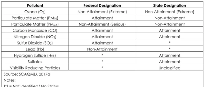
The USEPA and CARB determine the air quality attainment status of designated areas by comparing local ambient air quality measurements from state or local ambient air monitoring stations with the CAAQS and NAAQS. These attainment designations are determined on a pollutant-by-pollutant basis. Consistent with federal requirements, an unclassifiable designation is treated as an attainment designation. Table 3 presents the federal and State attainment status for the SCAB. Attainment means that the ambient air quality meets the air quality standards and non-attainment means that the ambient air quality does not meet air quality standards.
As shown in Table 3, the Project site is in an area designated non-attainment for both the federal and State standards for O3 and PM2.5, the State standard for PM10 and the federal standard for Pb. Because the SCAB currently exceeds several State and federal ambient air quality
standards, the SCAQMD is required to implement strategies to reduce pollutant levels to recognized acceptable standards.
Table 3 Attainment Status of South Coast Air Basin
Pollutant Federal Designation State Designation Ozone (O3) Non-Attainment (Extreme) Non-Attainment (Extreme)
Particulate Matter (PM10) Attainment Non-Attainment
Particulate Matter (PM2.5) Non-Attainment (Serious) Non-Attainment
Carbon Monoxide (CO) Attainment Attainment
Nitrogen Dioxide (NO2) Attainment Attainment
Sulfur Dioxide (SO2) Attainment *
Lead (Pb) Non-Attainment *
Hydrogen Sulfide (H2S) * Attainment
Sulfates * Attainment
Visibility Reducing Particles * Unclassified
Source: SCAQMD, 2017a Notes:
(*) = Not Identified/ No Status.
The SCAQMD in conjunction with the Southern California Association of Governments (SCAG), CARB, and USEPA recently prepared the 2016 Air Quality Management Plan (AQMP) (SCAQMD, 2017b). The purpose of the 2016 AQMP is to provide a comprehensive and integrated program to lead the SCAB into compliance with the federal ozone and particulate matter standards. The 2016 AQMP accounts for projected population growth, predicted future emissions in energy
NAAQS attainment designation. These control strategies are either organized into the SCAQMD rules and regulations, or otherwise set forth as formal SCAQMD recommendations to other agencies.
The 2016 AQMP includes policies that are consistent with the SCAQMD and specify review according to the recommendations of SCAQMD guidelines. Other policies are aimed at reducing transportation emissions and emissions from major stationary sources.
The Project would be subject to the following general SCAQMD rules and regulations:
• Regulation IV - Prohibitions
o Rule 401 – Visible Emissions o Rule 402 – Nuisance o Rule 403 – Fugitive Dust
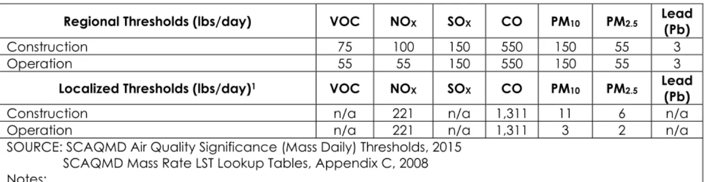
The SCAQMD has adopted regional and localized significance thresholds (LSTs) to determine the significance of a project’s potential air quality impacts. Separate thresholds of significance have been adopted for the construction and operation phases of projects. The LSTs were developed by the SCAQMD to assist lead agencies in analyzing localized air quality impacts from projects. LSTs look-up tables for one, two, and five acre proposed projects emitting CO, nitrogen oxides (NOx), PM2.5 or PM10 were prepared for easy reference according to source receptor area. The LSTs methodology and associated mass rates are not applicable to mobile sources travelling over the roadways. It should be noted that SCAQMD does not mandate LSTs for new
construction projects; more importantly, LSTs are a voluntary approach to be implemented at the discretion of local agencies (SCAQMD, 2008).
Table 4, below, presents the regional and voluntary LSTs applied to the Project and used for purposes of this analysis. These LSTs are based on a five-acre site with a 25-meter receptor distance. Use of the five-acre and 25-meter site criteria represents a conservative approach as dispersion of emissions over the proposed 9.7-acre site would be greater than that for a five-acre site size. This is because the same mass of pollutants occurring on the larger 9.7 acre-site would lead to increased dispersion of pollutants and lower pollutant concentrations at receptors compared to a five-acre site which the LSTs are based on.
Table 4 SCAQMD Air Quality Significance Thresholds (Mass Daily Thresholds)
Regional Thresholds (lbs/day) VOC NOX SOX CO PM10 PM2.5 Lead (Pb)
Construction 75 100 150 550 150 55 3
Operation 55 55 150 550 150 55 3
Localized Thresholds (lbs/day)1 VOC NOX SOX CO PM10 PM2.5 Lead (Pb)
Construction n/a 221 n/a 1,311 11 6 n/a
Operation n/a 221 n/a 1,311 3 2 n/a
SOURCE: SCAQMD Air Quality Significance (Mass Daily) Thresholds, 2015 SCAQMD Mass Rate LST Lookup Tables, Appendix C, 2008 Notes:
1. Localized significance thresholds are from the SCAQMD lookup tables for Source Area 16 assuming a five-acre project site and a distance to the nearest sensitive receptor of 25 meters (proposed site size is 9.7 acres).
a) Conflict with or obstruct implementation of the applicable air quality plan?
Less Than Significant Impact with Mitigation Incorporated. Emissions below the SCAQMD mass emissions thresholds of significance presented in Table 4 would not be expected to conflict with or obstruct implementation of the applicable air quality plan. Project construction and
operation emissions were calculated using the California Emissions Estimator Model (CalEEMod). CalEEMod is a statewide land use emissions computer model designed to provide a uniform platform for government agencies, land use planning, and environmental professionals to quantify potential criteria air pollutant emissions associated with both construction and operations from a variety of land use projects.
The model quantifies direct emissions from construction and operations including vehicle use¸ off-road equipment, fugitive dust, off-gas from asphalt and landscaping maintenance. Default data (i.e., emission factors, trip lengths, meteorology, source inventory, etc.) have been
provided by the various California air districts to account for local requirements and conditions. The model is an accurate and comprehensive tool for quantifying air quality impacts from land use projects throughout California.
The Project would result in emissions of criteria air pollutants during construction primarily from off-road equipment and on-off-road vehicle exhaust and fugitive dust from grading/soil disturbing activities. Operation phase emissions of criteria air pollutants are primarily limited to exhaust from bike facility user and operation/maintenance personnel vehicle trips. Estimated unmitigated Project construction and operation emissions are summarized below in Tables 5 and 6,
respectively. Detailed emissions estimates and assumptions are provided in Appendix A (Project Emissions Estimates).
Table 5 Unmitigated Project Construction Emissions in Comparison to SCAQMD Significance Criteria
Peak Daily Emissions (lbs/day)
Component VOC NOX SOX CO PM10 PM2.5 Lead (Pb)
Construction Emissions 4.35 45.68 0.07 37.06 20.63 12.16 -- Regional Thresholds Construction 75 100 150 550 150 55 3 Localized Thresholds Construction n/a 221 n/a 1,311 11 6 n/a
Exceeds Regional Thresholds? No No No No No No n/a
Exceeds Localized Thresholds? No No No No Yes Yes n/a
Table 6 Unmitigated Project Operation Emissions in Comparison to SCAQMD Significance Criteria Peak Daily Emissions
(lbs/day)
Component VOC NOX SOX CO PM10 PM2.5 Lead (Pb)
Project Operation Emissions 11.09 0.10 <0.01 0.46 0.10 0.03 --
Regional Thresholds Operation 55 55 150 55 55 150 55
Localized Thresholds
Operation n/a 221 n/a 1,311 3 2 n/a
Exceeds Regional Thresholds? No No No No No No n/a
Exceeds Localized Thresholds? No No No No No No n/a
As shown in Table 5, Project construction emissions are below the applicable SCAQMD regional and localized mass emissions thresholds of significance except for the LSTs for PM10 and PM2.5. Emissions of PM10 and PM2.5 could therefore conflict with or obstruct implementation of the applicable air quality plan and are a potentially significant impact. As shown in Table 6, Project operation emissions are below all applicable SCAQMD regional and localized mass emissions thresholds. Project operation emissions would therefore not conflict with or obstruct
implementation of the AQMP and impacts would be less than significant. Mitigation Measures AQ-1 and AQ-2 below would be implemented to reduce construction PM10 and PM2.5 emissions. Mitigation Measures
AQ-1: Prior to the issuance of grading permits, OC Development Services shall confirm that the grading plan and specifications stipulate compliance with the following measures from the South Coast Air Quality Management District (SCAQMD) Rule 403 for fugitive dust suppression:
• Apply water three times daily to disturbed construction areas to limit visible dust emissions to no more than 20 percent opacity.
• All trucks hauling dirt, sand, soil, or other loose materials are to be covered or should maintain at least 2 feet of freeboard in accordance with the requirements of California Vehicle Code (CVC) Section 23114 (freeboard refers to vertical space between the top of the load and the top of the trailer).
• Vehicle travel on unpaved roadways shall be limited to 15 miles per hour or less to limit visible dust emissions to no more than 20 percent opacity.
AQ-2: Prior to the issuance of grading permits, OC Development Services shall confirm that the grading plan and specifications stipulate compliance with the following measures from the SCAQMD Handbook for fugitive dust suppression:
• A gravel apron, 25 feet long by road width, shall be located at the point of intersection of a paved public roadway and an unpaved work site exit, and maintained to dislodge mud, dirt, and/or debris from the tires of motor vehicles and/or haul trucks, prior to exiting the work site.
• A soil stabilizer shall be applied to unpaved construction site access routes to control PM10 emissions from fugitive dust.
• Ground cover shall be replaced in disturbed areas as quickly as possible to restore the area to its natural state, thereby decreasing the potential for emission of fugitive dust.
Construction PM10 and PM2.5 emissions were re-estimated assuming implementation of Mitigation Measures AQ-1 and AQ-2 using established SCAQMD fugitive dust control efficiencies. Estimated mitigated Project construction emissions of PM10 and PM2.5 are summarized below in Table 7. Detailed emissions estimates and assumptions are provided in Appendix A.
Table 7 Mitigated Project PM10 and PM2.5 Construction Emissions in Comparison to SCAQMD
Significance Criteria
Component PM10 PM2.5
Mitigated Construction Emissions 9.18 5.89 Localized Thresholds Construction 11 6
Exceeds Thresholds? No No
As shown in Table 7, Mitigation Measures AQ-1 and AQ-2 would reduce construction PM10 and PM2.5 emissions below the applicable LSTs. Construction emissions of PM10 and PM2.5 are therefore a less than significant impact with mitigation incorporated. Pre- and post-mitigation emissions estimates are included in Appendix A.
b) Violate any air quality standard or contribute substantially to an existing or projected air quality violation?
Less Than Significant Impact with Mitigation Incorporated. Emissions below the SCAQMD mass emissions thresholds of significance presented in Table 4 would not be expected to violate any air quality standard or contribute substantially to an existing or projected air quality violation. As discussed above in response 3.3(a), estimated Project emissions are below the applicable SCAQMD regional and localized mass emissions thresholds of significance except that during construction, the LSTs for PM10 and PM2.5 may be exceeded. Emissions of PM10 and PM2.5 during Project construction could therefore violate an air quality standard or contribute substantially to an existing or projected air quality violation and may therefore, lead to a potentially significant impact. Mitigation Measures AQ-1 and AQ-2 will be implemented to reduce construction PM10 and PM2.5 emissions. As shown in Table 7, Mitigation Measures AQ-1 and AQ-2 would reduce construction PM10 and PM2.5 emissions below the applicable LSTs. Construction emissions of PM10 and PM2.5 are therefore a less than significant impact with mitigation incorporated.
c) Result in a cumulatively considerable net increase of any criteria pollutant for which the
project region is non-attainment under an applicable federal or state ambient air quality standard (including releasing emissions which exceed quantitative thresholds for ozone precursors)?
Less Than Significant Impact with Mitigation Incorporated. In accordance with SCAQMD methodology, projects that do not exceed or can be mitigated to less than the daily threshold values do not add significantly to a cumulative impact. As discussed above, unmitigated estimated Project emissions are below the applicable SCAQMD regional and localized mass emissions thresholds of significance except for the LSTs for construction PM10 and PM2.5. Because unmitigated emissions of PM10 and PM2.5 are above the LSTs, the Project could cumulatively result in a considerable net increase of a criteria pollutant for which the Project region is in
non-attainment and could cause a potentially significant impact. Mitigation Measures 1 and AQ-2 would be implemented to reduce construction PM10 and PMAQ-2.5 emissions. As shown in Table 7, implementation of Mitigation Measures AQ-1 and AQ-2 would reduce construction PM10 and PM2.5 emissions below the applicable LSTs thresholds. Construction emissions of PM10 and PM2.5 are therefore a less than significant impact with mitigation incorporated.
d) Expose sensitive receptors to substantial pollutant concentrations?
Less Than Significant Impact with Mitigation Incorporated. Sensitive receptors are defined as populations that are more susceptible to the effects of pollution than the population at large. The SCAQMD identifies the following as sensitive receptors: residences, schools, daycare centers, playgrounds, and medical facilities. The Project site is bordered by sensitive receptors on all sides with single-family residences as close as approximately 25 meters to the Project site boundary. Projects that are below the SCAQMD LSTs presented in Table 4 would not be expected to expose sensitive receptors to substantial pollutant concentrations. These LSTs are based on a
five-acre site with a 25-meter receptor distance. Use of the five-acre site criteria represents a conservative approach because the same mass of pollutants occurring on the larger 9.7 acre-site would lead to increased dispersion of pollutants and lower pollutant concentrations at receptors compared to a five-acre site which the LSTs are based on.
As discussed above in response 3.3(a), estimated Project emissions are below the applicable SCAQMD localized mass emissions thresholds of significance except for the LSTs during construction for PM10 and PM2.5. Emissions of PM10 and PM2.5 could therefore expose sensitive receptors to substantial pollutant concentrations and are a potentially significant impact. Mitigation Measures AQ-1 and AQ-2 would be implemented to reduce construction PM10 and PM2.5 emissions. As shown in Table 7, implementation of Mitigation Measures AQ-1 through AQ-2 would reduce construction PM10 and PM2.5 emissions below the applicable LSTs. Construction emissions of PM10 and PM2.5 are therefore a less than significant impact with mitigation incorporated.
e) Create objectionable odors affecting a substantial number of people?
No lmpact. The SCAQMD has identified land uses subject to odor complaints. These land uses include agriculture (farming and livestock), wastewater treatment, food processing plants, chemical plants, composting, refineries, landfills, dairies, and fiberglass molding (SCAQMD, 1993). The Project involves construction, operation and maintenance of a bike facility within an existing regional park. The Project does not include a land use that SCAQMD has identified as subject to odor complaints and does not include any component with the potential to generate
3.4
BIOLOGICAL RESOURCES
Issues Potentially Significant Impact Less Than Significant Impact with Mitigation Incorporated Less than Significant Impact No Impact BIOLOGICAL RESOURCES: Would the Project:
a) Have a substantial adverse effect, either directly or through habitat modifications, on any species identified as a candidate, sensitive, or special status species in local or regional plans, policies, or regulations, or by the California Department of Fish and Wildlife or U.S. Fish and Wildlife Service?
b) Have a substantial adverse effect on any riparian habitat or other sensitive natural community identified in local or regional plans, policies, and regulations or by the California Department of Fish and Wildlife or U.S. Fish and Wildlife Service?
c) Have a substantial adverse effect on federally protected wetlands as defined by Section 404 of the Clean Water Act
(including, but not limited to, marsh, vernal pool, coastal, etc.) through direct removal, filling, hydrological interruption, or other means?
d) Interfere substantially with the movement of any native resident or migratory fish or wildlife species or with established native resident or migratory wildlife corridors, or impede the use of native wildlife nursery sites?
e) Conflict with any local policies or ordinances protecting biological resources, such as a tree preservation policy or ordinance? f) Conflict with the provisions of an adopted
habitat conservation plan, natural community conservation plan, or other approved local, regional, or state habitat conservation plan?
a) Have a substantial adverse effect, either directly or through habitat modifications, on any species in local or regional plans, policies, or regulations, or by the California Department of Fish and Wildlife or U.S. Fish and Wildlife Service?
Less Than Significant Impact with Mitigation Incorporated.
Listed/Special-interest Species Protection
A field evaluation of biological resources was conducted at the Project site on December 7, 2016 to determine if local, State, or federally listed special-status plant or wildlife species are potentially present within a defined Biological Study Area or “BSA,” which includes the 9.7-acre project site and a 100-foot buffer surrounding the site. A Biological Resources Technical Report is attached as Appendix B. Although federal, State or locally protected wildlife species were not detected during the survey, site assessment revealed that the habitats within the Project site have the potential to support the following listed special-status species: western pond turtle
(Actinemys marmorata), western mastiff bat (Eumops perotis), yellow-breasted chat (Icteria
virens), least Bell’s vireo (Vireo bellii pusillus), American peregrine falcon (Falco peregrinus), and
yellow warbler (Setophaga petechia).
Direct impacts to nesting birds include ground-disturbing activities associated with construction of the Project and increased human presence. Potential indirect impacts during construction to nesting birds include: increased noise levels from heavy equipment, increased human
disturbance, exposure to fugitive dust, the spread of noxious weeds, and disruption of breeding or foraging activity due to routine maintenance activities. Weed abatement through herbicide application or mechanized tools could also affect nesting.
If implementation of the Project were to impact special-status species, these impacts would be considered significant. Therefore, Mitigation Measures BIO-1, BIO-2, BIO-3 and BIO-4, which would require focused nesting bird and western pond turtle surveys to ensure that special-status birds and turtles are not impacted by the Project, general pre-construction wildlife surveys to relocate common and special-status wildlife outside of established work limits, consultation with USFWS and/or CDFW, and biological monitoring to ensure that common and special-status wildlife are not impacted during construction activities would be implemented to mitigate these potentially significant impacts. Implementation of these Mitigation Measures would ensure that potential impacts to the listed special-status species identified above, are reduced to a less than significant level.
Nesting Bird Protection
No active (occupied) or inactive nests were detected during the 2016 surveys conducted in support of the Initial Study/Mitigated Negative Declaration. However, the surveys were not conducted during typical nesting bird season (typically February 1 through September 15);
potential nesting habitat for raptors and passerines (perching birds), therefore Mitigation Measure BIO-1 requires surveys be conducted approximately one week, and then again 48 hours prior to the start of construction activities.
Project activities have the potential to impact nesting birds through direct impacts such as ground-disturbing activities associated with construction activities and increased human
presence. During the breeding season, construction activities could result in the displacement of breeding birds and the abandonment of active nests. Potential indirect impacts could include the deterioration of habitat as a result of the spread of noxious weeds, increased noise levels from heavy equipment, exposure to fugitive dust, and increased human. Weed management could also affect nesting.
During operation and maintenance of the Project, impacts to nesting birds would include increased human disturbance, exposure to fugitive dust, the spread of noxious weeds, and disruption of breeding or foraging activity due to routine maintenance activities. Weed abatement through herbicide application or mechanized tools could also affect nesting. Therefore, construction activities have the potential to adversely impact nesting birds, particularly if construction activity occurs within nesting bird season. Such impacts would be considered significant under the Migratory Bird Treaty Act (MBTA) and Section 3503.5 of the California Fish and Game Code. Therefore, Mitigation Measure BIO-4, which requires construction to be scheduled around the nesting season or provide full-time biological monitoring during construction, is proposed to mitigate the potential impacts. The
implementation of this Mitigation Measure would ensure that potential impacts to nesting birds are reduced to a less than significant level.
Mitigation Measures
BIO-1 Nesting Bird Surveys and Avoidance Measures: Prior to initial site disturbance seasonally timed presence/absence surveys for nesting birds shall be conducted by a qualified biologist. The qualified biologist must be approved by OC Development Services prior to the commencement of surveys. If construction activities carry over into a second nesting season(s) the surveys shall be completed annually until the Project is constructed. A minimum of three survey events, three days apart, shall be conducted (with the last survey no more than three days prior to the start of site disturbance), if construction is scheduled to begin during avian nesting season (February 15 through September 15); surveys for raptors shall be conducted from January 1 to August 15. Surveys shall be conducted within 500 feet of all Project activities.
If least Bell’s vireo or other special-status species are observed, consultation with United States Fish and Wildlife Service (USFWS) and/or California Department of Fish and Wildlife (CDFW)will be required. If breeding birds with active nests are found prior to or during construction, a qualified biological monitor shall establish a 300-foot buffer around the
nest and no activities will be allowed within the buffer(s) until the young have fledged from the nest or the nest fails. The prescribed buffers may be adjusted by the qualified biologist based on existing conditions around the nest, planned construction activities, tolerance of the species, and other pertinent factors. Limits of avoidance shall be demarcated with flagging or fencing. The qualified biologist shall conduct regular monitoring of the nest to determine success/failure and to ensure that Project activities are not conducted within the buffer(s) until the nesting cycle is complete or the nest fails. The biologist shall record the results of the recommended protective measures described above If construction occurs outside of avian nesting season, only a single
presence/absence survey will be required.
BIO-2 Focused Western Pond Turtle Surveys and Avoidance Measures: Prior to ground disturbance or vegetation clearing, a qualified biologist shall be retained to conduct focused surveys for western pond turtle within the Project site and adjacent habitats to a distance of 200 feet away. The qualified biologist must be approved by OC
Development Services prior to the commencement of surveys. Focused surveys shall occur between 1 April and 1 September (breeding season), the turtle’s egg laying season, and shall consist of a minimum of four daytime surveys, to be completed prior to ground disturbance or vegetation clearing. The qualified biologist shall conduct focused, systematic surveys for western pond turtle nesting sites. The survey area shall include all suitable nesting habitat located within 200 feet of occupied habitat in which ground disturbance will occur. Surveys will entail searching for evidence of pond turtle nesting, including remnant eggshell fragments, which may be found on the ground following nest depredation.
If an active western pond turtle nesting area would be adversely impacted by
construction activities, the biologist shall establish a no-disturbance buffer around each active nest. The biologist shall determine the buffer, in coordination with California Department of Fish and Wildlife (CDFW), based on the species present and surrounding habitat. Limits of avoidance shall be demarcated with flagging or fencing. The biologist shall record the results of the recommended protective measures described above and shall submit a memo summarizing any nest avoidance measures to the County to document compliance with applicable State and federal laws pertaining to the protection of special-status species. No construction or ground disturbance activities shall be conducted within the buffer until the biologist has determined the nest is no longer active and has informed the construction supervisor that activities may resume. If avoidance of the nesting area is determined to be infeasible, the qualified biologist shall coordinate with the CDFW to identify if it is possible to relocate the pond turtles. Eggs or hatchlings shall not be moved without written authorization from the CDFW.
present full time during all vegetation removal activities immediately adjacent to, or within, habitat that supports populations of western pond turtles, and part time for all remaining activities. If the installation of fencing to prevent turtles from entering the work area is deemed necessary by the qualified biologist, one pre-construction survey for southwestern pond turtles shall be conducted at the time of the fence installation. BIO-3 Terrestrial Wildlife Pre-Construction Surveys and Biological Monitoring: Prior to ground
disturbance or vegetation clearing within the Project site, a qualified biologist shall conduct surveys for terrestrial wildlife (no more than 14 days prior to site disturbing activities) where suitable habitat is present and directly impacted by construction activities. The qualified biologist must be approved by OC Development Services prior to the commencement of surveys. Terrestrial wildlife found within the Project site or in areas potentially affected by the Project shall be relocated to the nearest suitable habitat that will not be affected by the Project, as determined by the biologist. Special-status
terrestrial species found within areas to be impacted by the Project shall be relocated by an authorized biologist to suitable habitat outside the impact area.
A qualified biologist shall be present during initial ground disturbance for each phase of construction. Once initial ground disturbance is complete, monitoring will occur
periodically during all construction activities. The qualified biologist(s) shall be present at all times during ground-disturbing activities immediately adjacent to, or within, habitat that supports populations of listed or special-status species.
BIO-4 Nesting Bird Protection Measures: To avoid impacts to nesting birds and to comply with the Migratory Bird Treaty Act, clearing of vegetation shall occur between non-nesting (or non-breeding) seasons for birds (including raptors (generally, September 15 to January 1). If adherence to this avoidance schedule is impossible, due to unforeseen construction delays or similar situations as determined and approved by OC Development Services, the alternative is to carry out vegetation removal activities associated with construction under the supervision of a qualified biologist.
A preconstruction survey for nesting birds shall be conducted by a qualified biologist if clearing vegetation is conducted within the bird nesting season (September 1 to January 31). The qualified biologist must be approved by OC Development Services prior to the commencement of surveys. The survey shall consist of full coverage of the construction footprint and buffer. If no active nests are found, no additional measures are required. If “occupied” nests are found, the biologist shall map the nest locations, utilizing GPS equipment. The nesting bird species, and, to the degree feasible, the nesting stage would be documented (e.g., incubation of eggs, feeding of young, near fledging). The biologist shall establish a no-disturbance buffer around each active nest. The biologist shall determine the buffer (typically 300 feet of the nest or 500 feet for raptors), in coordination with California Department of Fish and Wildlife (CDFW), based on the species present and surrounding habitat. Limits of avoidance shall be demarcated with
flagging or fencing. The biologist shall record the results of the recommended protective measures described above and shall submit a memo summarizing any nest avoidance measures to the County to document compliance with applicable State and federal laws pertaining to the protection of native birds. No construction or ground disturbance activities shall be conducted within the buffer until the biologist has determined the nest is no longer active and has informed the construction supervisor that activities may resume.
b) Have a substantial adverse effect on any riparian habitat or other sensitive natural
community identified in local or regional plans, policies, and regulations or by the California Department of Fish or U.S. Fish and Wildlife Service?
Less Than Significant Impact with Mitigation Incorporated. Two “sensitive” riparian habitats, black willow-arroyo willow thickets and black willow-mulefat thickets, are present within the Project site and would be impacted by proposed construction activities; 0.15 acres and 0.03 acres
respectively. Both habitats have an “S3” designation, which indicates that they are vulnerable due to a restricted range, relatively few populations (often 80 or fewer), recent and widespread declines; global and state ranks are determined by the NatureServe Network and recognized by the CDFW. Potential loss of these sensitive riparian plant communities would be considered a significant impact.
Riparian habitats, including ephemeral and perennial streams, are biologically productive and diverse, and are the exclusive habitat of several threatened or endangered wildlife species and many other special-status species. Riparian and wetland habitats are highly productive
ecosystems that also provide drinking water sources and foraging, nesting, and cover habitat for a diverse assemblage of wildlife species, both within the riparian habitats and adjacent upland habitats. Many wildlife species are wholly dependent on riparian habitats throughout their life cycles, and many others use riparian habitats only during certain seasons or life history phases. For example, certain mammals require drinking water or cool shaded cover during summer but otherwise may live in upland habitats. Numerous amphibians breed in aquatic habitats but spend most of their lives in uplands.
The Project has been designed to minimize the removal of on-site trees. However, approximately five non-native and two native trees would be removed as part of construction activities; this includes Peruvian pepper (Schinus molle) and Fremont cottonwood (Populus fremontii) respectively.
Construction of the Project would remove vegetation, alter soil conditions, and have the potential to result in the loss of native seed banks within portions of the Project site. Construction activities could also result in the spread of noxious weeds within the Project site and adjacent habitats. During Project operations, impacts would occur during routine maintenance activities and could include trampling or crushing of native vegetation by foot traffic, alterations in
topography and hydrology, increased erosion and sedimentation, and the introduction of non-native, invasive plants due to increased human presence on foot or equipment.
Mitigation Measures BIO-5 through BIO-7 below, which include minimizing vegetation removal, compensation for impacts to native vegetation communities, replacement of removed trees, and implementation of best management practices (i.e., worker environmental awareness training and establishment of construction exclusion zones) would be implemented to mitigate these potential impacts. Implementation of BIO-5 through BIO-7 would ensure that potential impacts to sensitive habitats (approximately 0.18 acres), is reduced to a less than significant level.
Mitigation Measures
BIO-5 Vegetation Removal and Replacement: Construction activities shall be done in such a manner as to minimize the removal of native vegetation. If native vegetation removal cannot be avoided, the impacted plant communities shall be replaced at a mitigation ratio of 1:1. The compensation for the loss of habitats may be achieved either by a) on-site habitat creation or enhancement willow/mulefat communities or b) off-on-site creation or enhancement of willow/mulefat communities.
Prior to the removal of native vegetation, if on or off-site mitigation is required, a Habitat Mitigation and Monitoring Plan shall be prepared and submitted to the County for approval that will guide all restoration and monitoring activities. This plan shall include, at a minimum, the following:
• Proposed species list for creation/enhancement;
• Planting/seeding methodology;
• Irrigation plan;
• Weeding schedule;
• Success criteria;
• Monitoring methodology and schedule; and
• Reporting requirements.
BIO-6 Tree Removal and Replacement: Native trees removed as part of the Project will be replaced at a 5:1 ratio. All non-native trees removed will be replaced with appropriate native species. Once mature, these native species will provide similar structure and height, at a 3:1 ratio. All replacement trees shall be planted within or adjacent to the Project site.
Supplemental irrigation shall be provided after initial planting and when needed thereafter for a period of at least two years. All planted trees shall be monitored, by a qualified biologist/botanist, monthly for the first year after planting and quarterly
thereafter. At a minimum sufficient data shall be collected to document the progress of upward growth and trunk diameter. This will also include photos of each tree and a written description as to the health of each tree. During the first year of monitoring a monitoring status memorandum shall be prepared and submitted to the County for review on a quarterly basis. In subsequent years, a monitoring status memorandum shall be prepared and submitted to the County twice a year. Monitoring shall be conducted for a minimum of five years to ensure establishment of the planted trees.
BIO-7 Best Management Practices: Prior to the issuance of any grading permits, the applicant shall submit grading plans and specifications to OC Development Services, which indicate that the Project shall implement the following Best Management Practices (BMPs):
• Prepare and conduct a Worker Environmental Awareness Training to all construction personnel that provides regulatory information, special-status species and sensitive habitat information;
• Establish construction exclusion zones and note the zones on all construction plans;
• Ensure all construction activities stay within the staked construction zone and do not go beyond the limits of approved disturbance;
• Minimize trimming/removal of vegetation within the Project impact areas;
• Restrict non-essential equipment to the existing roadways and/or disturbed areas to avoid disturbance to existing adjacent native vegetation; and
• Install and maintain appropriate erosion/sediment control measures, as needed, throughout the duration of work activities.
c) Have a substantial adverse effect on federally protected wetlands as defined by Section 404
of the Clean Water Act (including, but not limited to, marsh, vernal pool, coastal, etc.) through direct removal, filling, hydrological interruption, or other means?
Less Than Significant Impact with Mitigation Incorporated. Two jurisdictional water features, Fullerton Creek and an unnamed manmade drainage ditch connecting to Fullerton Creek, occur within the Project site (Appendix B). By virtue of its hydrological connectivity to Coyote Creek and subsequently with the Pacific Ocean, Fullerton Creek is potentially a “waters of the US”, subject to Clean Water Act, Section 404 jurisdiction. The drainage ditch serves to convey
These drainages are also likely afforded protection by the State, under Section 401 Water Quality Certification and Section 1600 Streambed Alteration Agreement programs. Project construction is anticipated to permanently impact up to approximately 0.08 acres of Waters of the US and up to approximately 0.15 acres of Waters of the State.
The importance of intermittent and ephemeral streams to wildlife in arid environments is well known (Levick et al., 2008). Ephemeral drainages, such as Fullerton Creek, provide unique habitat that is distinct from the surrounding uplands, providing more continuous vegetation cover and microtopographic diversity than the surrounding uplands. Ephemeral and intermittent streams in the arid west provide important habitat for wildlife and are responsible for much of the biotic diversity (Levick et al., 2008). They have higher moisture content and provide shade and cooler temperatures within the channel. In cases where the habitat is distinct in species composition, structure, or density, wash communities provide habitat values not available in the adjacent uplands.
Direct impacts to State and federal waters would include the removal of native riparian vegetation, the discharge of fill, degradation of water quality, and increased erosion and sediment transport. Potential indirect impacts could include alterations to the existing
topographical and hydrological conditions and the introduction of non-native, invasive plant species. Operational impacts to jurisdictional habitats would be similar to direct and potential indirect impacts.
To minimize potentially significant impacts to jurisdictional waters, the Project would implement the construction of span bridges across the jurisdictional areas where the proposed trails intersect the drainage ditch. For Project related impacts to jurisdictional waters, as required by law, the County would comply with State and federal regulations regarding conducting Project activities in water courses and habitats under the jurisdiction of the State and federal
government. Pursuant to Section 401 and 404 of the CWA, the State Porter-Cologne Act, and Fish and Game Code 1600, the Project proponent would be required to procure a Section 404 permit from the USACE, a Section 401 Water Quality Certification from the SDRWQCB and a Section 1600 Streambed Alteration Agreement permit from the CDFW prior to initiating activities that may result in disturbance within the jurisdictional areas. Conditions outlined in permits from the above agencies may require compensatory mitigation for impacts to jurisdictional resources. Project-related impacts to jurisdictional waters would be considered significant without
mitigation. Therefore, Mitigation Measures BIO-3 (Te