Master Thesis in Geographical Information Science nr 85
Luka Jovičić
2018
Department of
Physical Geography and Ecosystem Science
Centre for Geographical Information Systems
Lund University
Sölvegatan 12
S-223 62 Lund
Sweden
Spatial Data Harmonisation in
Regional Context in Accordance
with INSPIRE Implementing Rules
ii
Luka Jovičić (2018). Spatial data harmonisation in regional context in accordance with the
INSPIRE implementing rules
Master degree thesis, 30 credits in Master in Geographical Information Science (GIS)
Department of Physical Geography and Ecosystem Science, Lund University
iii
Spatial data harmonisation in regional context in
accordance with the INSPIRE implementing rules
Luka Jovičić
Master thesis, 30 credits, in Geographical Information
Sciences
Supervisors
Lars Harrie
Dept of Physical Geography and Ecosystem Science
Faculty of Science, Lund University
Vlado Cetl
Faculty of Geodesy, Chair of Spatial Information
Management
v
Abstract
Spatial data seamless exchange and interoperable usage has become a necessity in efficient data management and competitive positioning in the European Union. Conceptual and technical framework for the spatial data and services interoperability is specified within the EU INSPIRE Directive. The Directive provides flexible and modular structure, giving the opportunity for customisation of the data specifications and usage. From the data publisher level to the European spatial data infrastructure, this opened the question of disharmony of the spatial data structure and sharing. Arisen challenges in data harmonisation process are thus subject of interest for different formalisation approaches.
This study approaches the spatial data harmonisation process focusing on the area of Western Balkans, the region of Europe with countries that have similar interest for implementation of the INSPIRE Directive. With the main aim to propose the improvement to regional data harmonisation process, the study (1) analyses the INSPIRE data harmonisation process, (2) assesses critical factors of the process in the region and (3) tests the implementation of the INSPIRE data model formalised in accordance with user needs. INSPIRE Theme Geology is in focus in terms of its practical application to each of the objectives, throughout the thesis.
The INSPIRE data harmonisation process is analysed in order to better comprehend the process, determine standards for approach to harmonisation and provide reference to best practice cases as the source material for data publishers’ capacities building. Critical factors of the harmonisation process are assessed through semi-structured questionnaire and the responses from the competent representatives of each of the countries of the Western Balkans region. Finally, the outcomes of the INSPIRE defined harmonisation process and user needs are formalised and implemented on a practical example, a geological dataset.
Results of the study present the structure and formalisation concepts of the INSPIRE data model, its extensibility, means for securing interoperability and standardised approach in defining data model elements. The responses to the questionnaire have shown that, on a regional level, spatial data managers have made certain progress towards compliance and are familiar with the Directive, but also still lack a coordinated approach and implementation guidance. Aside from the low capacities, the respondents’ view is that due to the current state of the data structures, harmonisation is a highly complex process and a goal that is difficult to reach. The user needs and data model structure characteristics of the regional geology dataset that were obtained, were integrated in the formal description of the source and target INSPIRE data model. The concept required structuring the source model to meet both INSPIRE and local requirements. Source data schema and data itself are successfully transformed into the target data model and validated against the INSPIRE requirements. The general aim was reached by implementing the INSPIRE data harmonisation with fulfilling the main objectives – creating market-oriented, interoperable and accessible dataset, meeting national legal requirements towards the geological data management and increasing efficiency of data usage. Further application of the developed approach is seen as the implementation methodology for other INSPIRE themes and other geographical regions.
vi
Contents
Abstract ... v 1. Introduction ... 1 1.1. Problem statement ... 2 1.2. Aim ... 2 1.3. Methodology ... 3 1.4. Expected results ... 3 1.5. Disposition ... 3 2. Background ... 52.1. INSPIRE Directive and Implementing Rules ... 5
2.2. Data harmonisation process – the INSPIRE Theme Geology ... 8
2.3. INSPIRE model formalisation rules ... 9
2.3.1. INSPIRE Generic conceptual model... 9
2.3.2. Data transformation solutions project - Extending INSPIRE Data Specifications ... 10
2.3.3. ELF project approach in formalising the INSPIRE data model ... 11
2.3.4. The GeoSmartCity ... 12
2.4. Underlying concepts of INSPIRE data model formalisation ... 13
2.4.1. Standards regulating geological spatial data structure - GeoSciML ... 13
2.4.2. Data model formal description ... 16
2.4.3. Schema and data transformation tools ... 16
2.4.4. Validation of the data model ... 18
2.5. Western Balkans countries commons in context of spatial data governance ... 19
2.6. Overview of the experiences in data harmonisation process ... 21
3. Study 1 - Analysis of critical factors of the regional INSPIRE harmonisation model... 25
3.1. Methods ... 25
3.1.1. Overview and questionnaire ... 25
3.2. Results of the questionnaire ... 26
3.2.1. Western Balkans advance in INSPIRE Theme Geology ... 31
4. Study 2 - Implementation of INSPIRE data harmonisation ... 33
4.1. Methods ... 33
4.1.1. Source model and data preparation ... 34
4.1.2. Target model and data transformation ... 36
4.2. Results ... 38
4.2.1. Implementation of the INSPIRE data harmonisation locally ... 41
vii
5.1. Comprehending the INSPIRE Directive ... 43
5.2. Formalisation approach ... 43
5.3. Formalisation concept and tools... 44
5.4. Possibility for common spatial data model ... 44
5.5. Western Balkans constellation of the spatial data modelling ... 45
5.6. Data model formalisation and implementation ... 45
6. Conclusions ... 47
References ... 49
Appendices ... 53
Appendix A - Main UML stereotypes in INSPIRE Geology schema ... 53
Appendix B - Theme Geology Conceptual data model ... 54
Appendix C – Questionnaire ... 57
Appendix D – Institutions contacted for participation in the questionnaire ... 67
Appendix E – Conceptual data model of the basic geological map ... 68
Appendix F – Formalising the logical data model for the Geological map of FYR Macedonia in scale 1:500,000 ... 73
viii
List of Figures
Figure 1-1 Work composition flow ... 4
Figure 2-1 INSPIRE technical architecture overview (Drafting Teams ‘Data Specification’ ‘Network Services’ ‘Metadata’, 2007) ... 6
Figure 2-2 Inspire implementation roadmap (European Commission, 2015) ... 7
Figure 2-3 Cross theme interoperability (Tóth et al. 2012,p 25) ... 9
Figure 2-4 Geonovum study on INSPIRE model extending, Process flow (Grothe, Bulens & Reitz, 2016) ... 10
Figure 2-5 GeoSciML application schema segment – GeologicFeatue (IUGS Commission for the Management and Application of Geoscience Information, 2013) ... 15
Figure 2-6 The HUMBOLDT Framework (The HUMBOLDT project, 2010) ... 17
Figure 2-7 Schematic on relations of INSPIRE IR and TG requirements and the Abstract and Executable tests ... 18
Figure 2-8 Western Balkans region countries ... 19
Figure 2-9 Overall harmonization approach (Hedefalk & Östman 2011, p. 32) ... 22
Figure 2-10 Methodological workflow (Pereira et al. 2013, p. 131) ... 23
Figure 3-1 Stakeholders' need for harmonisation ... 27
Figure 3-2 Domains and level of following INSPIRE specifications in stakeholder institutions ... 28
Figure 3-3 INSPIRE legal coverage in Western Balkans countries... 28
Figure 3-4 Stakeholders’ approach in implementing harmonisation ... 29
Figure 3-5 Stakeholders' experience in implementing INSPIRE Directive ... 30
Figure 4-1 Geological Dataset Harmonising Process ... 33
Figure 4-2 Sheets coverage of the basic geological map in scale 1:100,000 of the former Yugoslavia (Geologicharka, 2012) ... 34
Figure 4-3 Layers of the Geological dataset of FYR Macedonia digitised and visualised in ESRI ArcGIS for Desktop (Jovičić, 2016) ... 36
Figure 4-4 Source and target data model schemas described in Appendix G ... 37
Figure 4-5 Visualisation of the source data and on-the-fly representation of the transformed data .. 38
Figure 4-6 Instance validation error example in HALE ... 39
Figure 4-7 Comparison of the source and target schema values and the validated elements status list ... 40
Figure 4-8 GML file import, validation and use in GIS client ... 41
Figure B-1 INSPIRE Consolidated UML Model (European Commission, 2017b) ... 54
Figure B-2 Schema of the INSPIRE data model segment, theme Geology. Source: (INSPIRE Thematic Working Group Geology, 2011) ... 55
Figure B-3 Feature catalogue elements – example of GeologicFeature attributes and associations description. Source: (INSPIRE Thematic Working Group Geology, 2011) ... 56
Figure E-1 Basic geological map, lithological units’ structure ... 68
Figure E-2 Sediments and their structure according to mapping principles of the basic geological map (Pavlov et al., 2015)... 69
Figure E-3 Magmatic rocks and their structure according to mapping principles of the basic geological map (Pavlov et al., 2015) ... 70
Figure E-4 Metamorphic rocks and their structure according to mapping principles of the basic geological map (Pavlov et al., 2015) ... 71
ix
Figure E-6 Types of point objects of the basic geological map (Pavlov et al., 2015) ... 72
Figure G-1 Imported source and target data model schemas ... 77
Figure G-2 INSPIRE Consolidated UML Model, Geology core overview schema with highlighted segment of interest ... 78
Figure G-3 INSPIRE Consolidated UML Model, Geology core class diagram with selected classes – target schema ... 79
Figure G-4 Mapping functions overview within HALE ... 80
List of Tables
Table 2-1 Adopted from (Hopfstock, 2016) Table 2-1 – ELF extensions ... 12Table 2-2 SWOT analysis of the status of INSPIRE in the WB countries, adopted from (Cetl, Tóth & Smits, 2014) ... 20
Table A-1 Main UML stereotypes in INSPIRE Geology schema adapted from (INSPIRE Thematic Working Group Geology, 2011) ...53
Table D-1 Institutions contacted for participation in the questionnaire ... 67
Table F-1 Data model class description: Mapped unit ... 73
Table F-2 Data model class description: Tectonic unit ... 73
Table F-3 Mapped unit feature description ... 74
Table F-4 Tectonic unit feature description ... 74
Table G-1 Source model feature class litologija describing mapped units ... 75
Table G-2 Source model feature class tektonika describing strucutral units ... 76
Table G-3 Mapping functions in relation to source and target schema objects for MappedUnit class80 Table G-4 Mapping functions in relation to source and target schema objects for StructuralUnits class ... 81
1
1.
Introduction
Spatial character of data plays an important role in the decision-making process within public institutions. A multidisciplinary approach in the fields of natural resources management, environmental risk assessment or infrastructural objects planning imply the need for wider use of spatial data across industrial domains, with various data sources and more utilisation possibilities. During the beginning of the 2000s, the situation in this domain showed severe limitations in spatial data utilisation in policies related to environmental issues (INSPIRE, 2003).
At the European Union level, the limitations were tackled by the framework of environmental spatial information sharing among public institutions, called European Spatial Data Infrastructure (SDI). It is formalised as the INSPIRE framework Directive for sharing geospatial information in the European Union (The European Parliament and the Council of the European Union, 2007) enabling discovery, access and data exchange from various sources, for various needs without limitation in an effective and flexible way. Starting from the fact that the data owners and providers come from diverse industry fields, working with different procedures, standards and at different quality levels, as well as the fact that INSPIRE does not enforce change of provider’s data nor data model, the essence of having functional SDI is a seamless use of data. To achieve such use, INSPIRE defines implementing rules which enable provider’s data harmonisation with the INSPIRE model. In the geospatial domain this approach is known as the interoperability concept. As defined by the INSPIRE Directive, interoperability ‘means the possibility for spatial data sets to be combined, and for services to interact, without repetitive manual intervention, in such a way that the result is coherent and the added value of the data sets and services is enhanced’ (The European Parliament and the Council of the European Union, 2007).
Each organisation that implements the INSPIRE Directive can have their own approach and be unique in their view of reaching harmonisation. Across Europe, a number of different approaches and implementation models have been practiced and various experience levels were thereby reached. The data acquired in this fashion are harmonised on the EU level, in conformance with the INSPIRE requirements. Yet, specifics and consequently disharmony are still present on more local levels of data provider and user cooperation. These difficulties in reaching interoperability at local, national and regional levels come from the need for datasets and services that have a structure different from the INSPIRE specifications. Thus, striving towards interoperable and more open data on higher levels, brought out the importance of dealing with spatial data disharmony on lower levels. In recent years, various scientific projects, research and publications have been focusing on the topic of data harmonisation. For example the Humboldt (Villa et al., 2012) and the Plan4All (Neuschmid et al., 2010) are projects discussed in several scientific studies like: Hedefalk & Östman (2011); Tomas et al. (2015); Crompvoets et al. (2010); Tóth et al. (2012). These studies emphasise different aspects of the approach to spatial data harmonisation. The concepts these papers provide are discussed further in this thesis. This study discusses the aforementioned constellation focusing on a group of countries with mutual characteristics of interest for implementation of the INSPIRE Directive. The area can be referred to as the Western Balkans region, as used in the EU international affairs correspondence (Commission of the European Communities, 2008). The Western Balkans in this sense relates to the EU enlargement process initiative and consists of Albania, Bosnia and Herzegovina, the former Yugoslav Republic of
2
Macedonia (FYR Macedonia), Montenegro, Serbia, Kosovo* and Croatia (until joining the EU). This group has another historically tight related member – Slovenia, since all of the countries (except Albania) used to be part of former Yugoslavia. These countries share mutual historic development through which they built common political, infrastructural and social background of governance. Such development reflected institutions’ organisation, standards and information exchange as key factors for spatial data management (Cetl, Tóth & Smits, 2014). In this context, the study will focus and further refer to these countries as the Western Balkans region (including Croatia and Slovenia) in analysing ways of data harmonisation and the possibility for formalisation to better meet institutional and INSPIRE requirements towards seamless data sharing goals. The second, more formal reason for focusing on the chosen area is that all Western Balkans countries acknowledge and are in various stages of incorporating the INSPIRE Directive in their laws, thus accepting the concepts and obligations, as well as recognising the benefits of implementing such an infrastructure (Ogrizovic, 2013).
1.1.
Problem statement
On top of the shared development history of the governmental institutions within the Western Balkans countries, adoption of the legislature for the INSPIRE harmonisation process shows common challenges and builds very slowly in comparison with other countries (Aleksic, 2013). The first of these challenges can be formulated as the difference in structuring spatial data as the basis of supply of the required information. Spatial data as such is considered to have the required formats, to be in an up-to-date state and in conformity with the international standards as recommended by the INSPIRE implementing rules. The second important challenge is legislation, which needs to support data availability and accessibility. This is not the case in countries where data, products and services specifications date from decades ago, causing confrontation with the current requirements for data exchange, security issues and standards applied. The third challenge is the non-existence of supply and use of spatial data through web services, in a standardised structure and in an interoperable manner. This requirement brings out the question of technical capacities and know-how within the institutions.
The presented constellation reveals data structuring, national legislation and institutional capacities as critical factors in the endeavour for utilising data harmonisation within the Western Balkans. In addressing these challenges, the question is how can the INSPIRE harmonisation process serve as the basis for seamless data exchange in the Western Balkans region?
1.2.
Aim
The main motive of this study is to contribute to the qualitative approach to spatial data infrastructure development in Western Balkans, through the research of the INSPIRE Directive implementation. In light of that, the thesis general aim is to propose an improvement to the regional data harmonisation process through a technical approach for formalising the INSPIRE data model. Specific objectives for reaching the general aim were (1) studying the INSPIRE data harmonisation process, (2) analysis of the critical factors of the process in a regional context and (3) testing the implementation of the INSPIRE harmonisation process covering one INSPIRE spatial data theme. The results of these objectives provide the approach to developing a formalised INSPIRE model for the referred INSPIRE theme in a regional context.
*This designation is without prejudice to positions on status, and is in line with UNSCR 1244/1999 and the ICJ Opinion on
3
1.3.
Methodology
This thesis examines the stated problem firstly by studying the implementation of the INSPIRE data harmonisation, focusing on geology as a chosen thematic domain and the related INSPIRE implementing rules. Such approach was taken in order to retain the standards as a basis, to address other levels of cooperation (national and regional SDI), to review the underlying concepts of the harmonisation process and review examples from practice. Theoretical aspects are followed by study of identified critical regional factors of the harmonisation process within the referential organisations throughout Western Balkans. Analysis of referential institutions’ approaches to the harmonisation process is presented through a questionnaire. Afterwards a practical example within one Western Balkans national SDI stakeholder institution (FYR Macedonian Geological Survey) is studied. For this purpose, test data is being harmonised, following the general INSPIRE implementing rules for the theme Geology. The final output represents the developed approach to formalisation of the data harmonisation for INSPIRE theme Geology in order to improve regional INSPIRE implementation and spatial data management.
1.4.
Expected results
The main contribution of the research is the approach to formalisation of the INSPIRE data model for seamless harmonisation process of the INSPIRE theme Geology, in the Western Balkans region. On a higher level, with applicable standards applied and following the proposed methodology, an equivalent approach could be developed for other applicable INSPIRE themes and other geographical regions.
1.5.
Disposition
The study is formed with the following structure: In Chapter 1 the idea and the approach are formulated by describing the subject area, problem definition, aim and the methodology in order to achieve the envisioned results. Following that, Chapter 2 gives the theoretical background of the research and constellation in the field subject area, by analysis of the core domains of interest for the thesis. These domains are the legislative, the standards and experiences in INSPIRE Directive data harmonisation for the theme Geology on European and regional - Western Balkans levels. The theoretical background forms the base for Chapter 3 and the first study which analyses regional critical factors for the implementation of the INSPIRE data harmonisation. This was achieved by design and dissemination of a questionnaire which resulted in description of the critical factors. The second study is described in Chapter 4, covering the INSPIRE data harmonisation process practical implementation in a national SDI context. The results of the practical segments of the work are discussed within the Chapter 5 which reflects on the INSPIRE data harmonisation by evaluation of the two studies results and reaching the main aim of the thesis. In the end, Chapter 6 reviews the outcomes of the taken approach and the contribution to the INSPIRE data harmonisation on the national and the regional level.
4
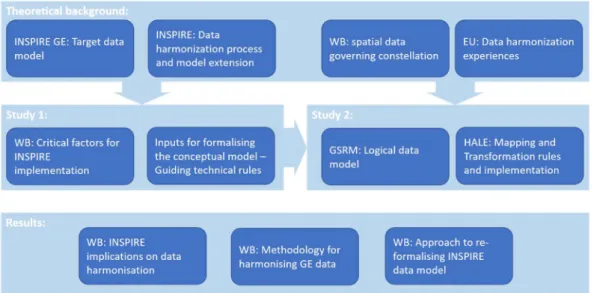
Figure 1-1 Work composition flow
WB: Western Balkans region, INSPIRE IR: INSPIRE Implementing Rules, INSPIRE GE: INSPIRE Geology Theme, GSRM: The Geological Survey of the Republic of Macedonia, HALE: Humboldt Alignment Editor software
5
2.
Background
The environment in which spatial data harmonisation process occurs is described firstly from the legal aspect in the section INSPIRE Directive and Implementing Rules, which discusses the approach developed from the needs on the European level. Secondly, the section Data harmonisation process – the INSPIRE Theme Geology focuses on one of the INSPIRE Directive themes, describing its structure and key concepts. Along with the following section INSPIRE model formalisation rules, these sections form the basis for the following studies later in this thesis. The formalised way of performing the existing process and approaches to the extension process are discussed in the next section -
Underlying concepts of INSPIRE data model formalisation. Following this top down approach, the regional context is presented in the section Western Balkans countries commons in context of spatial data govern, putting in focus the area of interest, describing its specifics and key elements that influence the existing harmonisation process. Finally, scenarios in the section Overview of the experiences in data harmonisation process, assess practical implementations of the previously discussed aspects of the harmonisation process. In this manner, the envisioned goals are given the base, means and comparability to be assessed in the following chapters.
2.1.
INSPIRE Directive and Implementing Rules
The INSPIRE (Infrastructure for SPatial InfoRmation in Europe) Directive takes an approach towards enabling spatial data availability, sharing and better use on the EU level. The Directive represents a framework for establishing the European spatial data infrastructure. The environmental policies and related activities are primarily in the thematic focus. INSPIRE defines an infrastructure architecture and relations of its elements with the aim of enabling seamless discovery, access and data exchange from various sources, for various needs without limitation in an effective and flexible way. (The European Parliament and the Council of the European Union, 2007). The main principles behind INSPIRE are (European Commission, 2017a):
- Data should be collected only once and kept where it can be maintained most effectively.
- It should be possible to combine seamless spatial information from different sources across Europe and share it with many users and applications.
- It should be possible for information collected at one level/scale to be shared with all levels/scales; detailed for thorough investigations, general for strategic purposes.
- Geographic information needed for good governance at all levels should be readily and transparently available.
- Easy to find what geographic information is available, how it can be used to meet a particular need, and under which conditions it can be acquired and used.
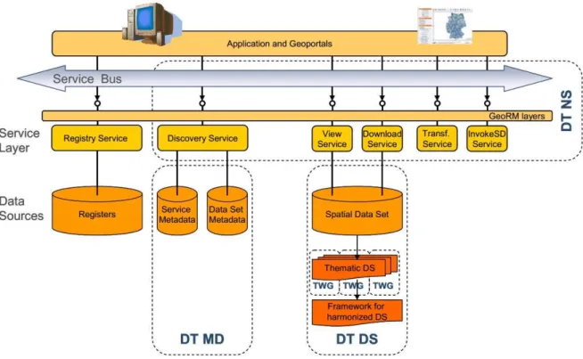
INSPIRE divides spatial data, activities and related themes into the three annexes covering 34 spatial themes in total. INSPIRE technical architecture provides the framework for the spatial data themes using the Implementing Rules (IR) for (Figure 2-1): (1) Metadata (which refers to the information describing data and services), (2) Data specifications (focusing on the data harmonisation based on their content and spatial component), (3) Network services (describing the technology and standards enabling spatial data and metadata availability), (4) Data and service sharing (consider terms of sharing including those referring to spatial data accessibility), (5) Spatial data services (technical specification
6
for the harmonised services defined by the INSPIRE) and (6) Monitoring and reporting (in the context of the INSPIRE implementation requirements).
Figure 2-1 INSPIRE technical architecture overview (Drafting Teams ‘Data Specification’ ‘Network Services’ ‘Metadata’, 2007) The IR specify the process of INSPIRE implementation as a whole and are mandatory for all member states.
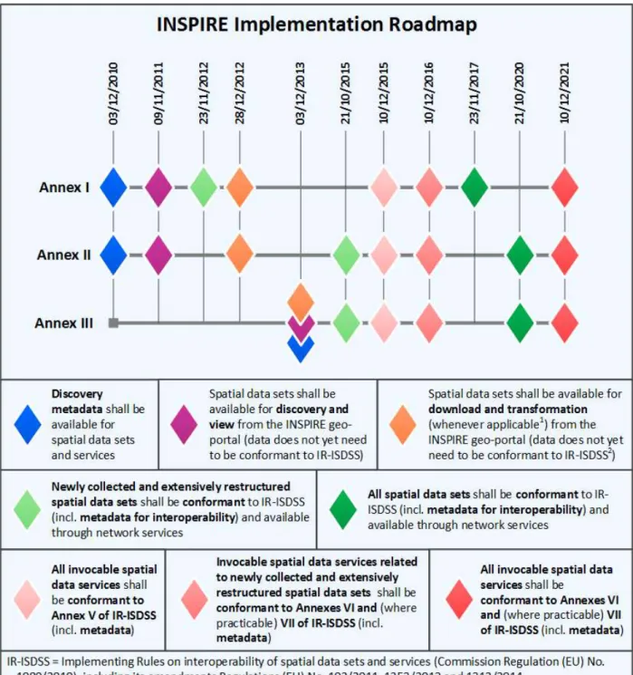
The IR on Metadata specify managing rules, structure and contents of the datasets and services information describing the INSPIRE themes. These were to be provided in required form until the end of 2013 (Figure 2-2).
IR Data specifications formalise requirements towards data models in order to define each of the INSPIRE themes specifics for interoperable usage. Corresponding documents that concretise conceptual IR are Technical Guidelines which are not obligatory like IR but specify ways and means of IR implementation as well as support to data providers in the data provision. This is the core concept for securing interoperable usage of spatial data across Europe. In that sense, Data specifications are the focus IR of this thesis and are discussed in more detail. The INSPIRE roadmap sets the ground for the implementation of new and extensively restructured data sets interoperability rules for the Annex I themes during 2013 while Annex II and III were to be available by the end of 2015. Spatial datasets still in use, depending on the Annex they belong, are to be available in the timeframe from the end of 2017 up to end of 2020.
Network services IR treat common interfaces for web services, enabling client applications and users to interact on an EU wide level. Web services refer to discovery, view, download, transformation and invoke services. According to the INSPIRE roadmap, network services (except invoke services) were to be implemented by the end of 2013 (Figure 2-2).
7
Figure 2-2 Inspire implementation roadmap (European Commission, 2015)
Data and service sharing is another subject of the INSPIRE IR, which is described as harmonisation terms which enable accessibility and usability of data and services. These are defined on a conceptual level, leaving concretisation to the individual national regulating bodies. Their full implementation was supposed to be provided by the end of 2013.
Spatial data service IR regulate interoperability of services themselves. This term considers seamless communication, execution and data transfer among services. This group of IRs are considered as advanced services and are out of the scope of this thesis but are mentioned in order to show the big
8
picture of the whole INSPIRE process. These are to be implemented in steps from the end of 2015 until 2021.
Finally, the IR on Monitoring and reporting describe requirements on advance and quality proofing of the INSPIRE implementation progress at the Member states’ level, on an annual basis. These refer to a number of implementation indicators statuses, inventory of included datasets and services, usage of the spatial data infrastructure and its performance.
The IRs are decomposed further within the Technical guidance documents which describe possible ways of IR implementation. It is specified that a localised approach is favoured, respecting national needs and regulations in Europe. Observing the contents of the IRs, their conceptual character can be divided into regulation of the spatial data technical environment and regulation of the spatial data itself. In that sense, Data Specification IR represent a core component in enabling interoperability and harmonisation.
2.2.
Data harmonisation process – the INSPIRE Theme Geology
This section presents the INSPIRE Data Specification IR related to the theme Geology as the concretisation of the previously described spatial data harmonisation framework. The focus is on the data model structure and relation to the stakeholder needs. The core of the data model are the application schemas which formalise the EU level target data model.
The INSPIRE Theme Geology IR relates to stakeholder needs by firstly defining the scope, purpose, use cases, model limitations and further development in order to provide better comprehension of the technical framework for geologists. In that sense, for the purpose of providing interoperable geological information, requirements from spatial data providers refer to geological materials characteristics (composition, structure, age, etc.), groundwater information as well as geomorphology of the rocks, boreholes and geophysics. Moreover, geological data goes broader than just Theme Geology and also covers sections of some other INSPIRE themes (Mineral Resources, Natural Risk Zones, Soil, Energy Resources). Thus, the field of geology includes several data models which are also further referenced by other themes. Although the thematic scope is clearly defined, in practice and in logical data modelling, this situation causes significant complexity of expressing geological objects and relations.
Conceptual data schema was developed by an international group of geology experts. The schema is based on the complex data model GeoSciML (more details on this model in section 2.4.1), which enables description of broader geological characteristics, thus allowing for model extension according to user needs.
Apart from this group of requirements from data producers, the IR involve some general elements and thematic specifics that contribute to interoperable data usage. These refer to cardinality, domain values, constraints etc. Using standardised Unified Modelling Language (UML) enables data model specification, automatic processing, encoding, querying and updating. UML is further explained in section 2.4.2. These general elements are covered either by the INSPIRE data model stereotypes or specific concepts like identifiers and geometric representations shown in Appendix A - Main UML stereotypes in INSPIRE Geologyschema.
Data specification for the theme Geology defines geological, hydrogeological and geophysical models. Of interest for this thesis is the geological model and the approach to its formal description is presented in Appendix B - Theme Geology Conceptual datamodel.
9
The schema diagram and the description of its elements in the Feature Catalogue show that elements of the INSPIRE model are well documented in terms of their type, explanation, comprehension, cardinality and adhering concept. In this way geologists are given a general model as a target in building INSPIRE compliant geological data. This is also the basis for building up a model that suits regional needs.
2.3.
INSPIRE model formalisation rules
There is a number of approaches which provide the main concepts of INSPIRE model formalisation. All of these are based on the INSPIRE Generic conceptual model (GCM) and develop according to specifics that refer to the different user requirements. The following sections discuss firstly the GCM, after which several examples are given in order to present the conceptual approach to the INSPIRE model formalisation.
2.3.1.
INSPIRE Generic conceptual model
Reflecting on the process of enabling data and services interoperability and usage within the spatial data infrastructures in Europe, the question of the approach to processing different thematic datasets in an interoperable manner is raised. INSPIRE thus took the approach of defining conceptual framework, which provides a repeatable data specification development methodology and general provisions for the data specification process which is valid for all spatial data themes (Tóth et al. 2012). Such a framework is known as the Generic conceptual model (INSPIRE Drafting Team ‘Data Specifications’, 2013) describing the concepts of data modelling and data specification development. It describes elements of the data specifications that can refer to any of the thematic groups as well as their relations and interdependencies (Figure 2-3).
Figure 2-3 Cross theme interoperability (Tóth et al. 2012,p 25)
The Generic conceptual model is on a higher level of abstraction in comparison to IR, describing their elements in conceptual level and providing means of their formalisation. This document is also a first stop in extending the basic INSPIRE data models, supporting and covering the extensions approach through the definition of core principles, where (INSPIRE Drafting Team “Data Specifications” 2013, p 128.):
10
Extending an INSPIRE data specification would imply at a minimum that:
- the extension does not change anything in the INSPIRE data specification but normatively references it with all its requirements
- the extension does not add a requirement that breaks any requirement of the INSPIRE data specification However, the extension may, for example, do any of the following:
- add new application schemas importing INSPIRE or other schemas as needed - add new types and new constraints in your own application schemas
- extend INSPIRE code lists as long as the INSPIRE data specification does not identify the code list as a centrally managed, non-extensible code list
- add additional portrayal rules
In addition to these general rules that are mainly implied by the rules of UML, further harmonisation will be achieved, if the extensions conform to all requirements of this document and the document ―Guidelines for the encoding of spatial data.
The INSPIRE Generic Conceptual Model contains all definitions for the data models’ formalisation, known as the INSPIRE UML profile. Each INSPIRE application schema has to be defined with UML version 2 according to ISO 19103 and ISO 19109. The INSPIRE Generic Conceptual Model furthermore defines which stereotypes that are allowed to be used in the INSPIRE UML Model. Most of the stereotypes have already been defined by other standards and are reused here (Mihaljević, 2011). In section 2.4.2, the role and characteristics of UML for the process of model extension are explained more thoroughly.
2.3.2.
Data transformation solutions project - Extending INSPIRE Data Specifications
A spin-off of the Fraunhofer Research Institute, wetransform, focuses on data transformation and development software solutions in this niche. Based on INSPIRE, ISO and OGC as spatial standards, they developed HALE – an open source desktop software for data transformation used around Europe as one of the most comprehensive solutions offered. With the support of the European Commission’s Directorate-General for Environment, the Joint Research Centre and the European Environmental Agency, Extending INSPIRE Data Specifications project was conducted by experts in the field of modelling and implementing the INSPIRE models from the data specifications. During 2016, the wetransform project resulted in an inventory of the current INSPIRE Model Extensions, the extension pattern catalogue and an end-to-end tutorial project. It recognises the INSPIRE Generic conceptual model, thus the focus and the contribution to the model formalisation approach is the methodology of the model extension.
11
Methodology firstly considers implementing the model by defining the work process, which serves as the input for the analysis phase. The analysis phase requires identification and studying of the requirements in terms of work processes and spatial data users, evaluation of local models and INSPIRE specifications. The next step is the comparison of the requirements between the existing and the INSPIRE specified models. The core phase is the extended model design which follows the described rules and builds upon the INSPIRE Generic conceptual model, links the required new classes to INSPIRE using UML concepts (Aggregation, Inheritance, Association, Composition, Multiple Inheritance) and adds new classes’ properties, whose linkage to INSPIRE properties is guided by the UML approach on defining constraints and code lists. Finally, the process of model design needs to be validated to test the compatibility with INSPIRE Data Specifications. Implementation of the designed model is performed using available data model transformation software. On the implementation level, testing and validation is done in regards to the target platform and required data usage. Finally, model extension can be deployed for public testing and, when needed, the whole process can iterate until the model reaches an acceptable level.
2.3.3.
ELF project approach in formalising the INSPIRE data model
The European Commission funded European Location Framework (ELF) project addressed the need for more detailed data in the cross-border areas in Europe, focusing on the existing spatial products and underpinned legacy requirements, like the EuroGeographics (the European National Mapping, Cadastral and Land Registry Authorities) products - EuroBoundaryMap, EuroRegionalMap, and European Commission Eurostat needs. The project formalised activities by building the technical infrastructure with a single access point to pan-European services. Of interest for this thesis is the ELF infrastructure component of the ELF data specifications (ELF DS), which describes the conceptual data model for creating harmonised pan-European reference data.
ELF DS follows the INSPIRE recommendations, namely INSPIRE Data Specifications and data model concepts defined within GCM. On the other hand, it incorporates user requirements through formalisation of the multi-scale compliant model which contains schemas covering themes from all three of the INSPIRE Annexes. The main principle of retaining INSPIRE compliancy requires a defining data model development approach, building it up through standardised modelling guidelines and finally implementing it through the ELF data model and application schemas. The approach is depicted in the Table 2-1.
12
Table 2-1 Adopted from (Hopfstock, 2016) Table 2-1 – ELF extensions
Identification of: Extensions Data Specification Data Model
corresponding concepts between INSPIRE and ELF model
Common part of the two models Data Quality conformance criteria validation Specification is implemented through Simple inheritance / specialisation concepts. Establishing data
capture criteria n/a concepts present
in INSPIRE but missing in existing data
Restricted
part Application schema not considered for ELF Feature types ignored Data types, attributes, associations constraint concepts present in existing data but missing in INSPIRE Extended
part New theme Add application schema New feature types Add feature
type New data types or
attributes Add data type or attribute New associations Add association
Developing of the ELF data specification took into consideration various needs of the stakeholders, like respecting different levels of detail, user requirements survey results, existing data specifications constraints etc. The Specification forms a framework, for which implementation is formalised within the ELF Modelling guidelines. The guidelines also describe the process of the INSPIRE data model extension. Matching concepts between schemas are analysed and in accordance to the described approach in the ELF DS, following the rule of inheriting INSPIRE concepts characteristics as needed, like adding optional attributes missing in INSPIRE, adding constraints to ensure ELF requirements, defining new feature types not present in INSPIRE, adding items in code lists, adding optional associations and implementing other applicable INSPIRE GCM conventions.
ELF project presented another way of realisation of the adopted concepts for developing the INSPIRE model following INSPIRE GCM. The key aspect of the Project approach is defining user needs and focusing on their formalisation in the process of model building in compliance with INSPIRE GCM.
2.3.4.
The GeoSmartCity
The GeoSmartCity (GSC) project started with the aim to contribute to added value applications and services development using geographical open data from the cities towards the Smart Cities concept (European Research Institutes’ initiative towards low-carbon Europe). The project aimed at building up a framework for utilising available data through the creation of pilot applications and services. It draws on the consolidated standards INSPIRE represents. Its orientation towards an interoperable environment, enabling various data providers and users to cooperate, has led to solutions like GeoSmartCity Data Catalogue, Data Portal, Client Side API and support resources like Validation Service, Codelists Manager etc. (Reitz, 2016)
In regards to data modelling, GSC firstly used a template model requirements file from the users, then did the comparison with INSPIRE Data Specifications, aligning requirements grouped into common classes, after which, the needed extensions in accordance to the acquired requirements were created,
13
along with schema maintenance and revision instructions, and finally validation of the results through available software tools.
The process of extending the data model considered adding new attributes which were guided by the principle of inheriting INSPIRE feature types characteristics. Also, new feature types were introduced to the model in order to formalise concepts exceeding the ones covered by the INSPIRE schema. The same was done in relation to code lists which were not present in the INSPIRE model. As an automation approach, open source software tool Re3gistry was used to manage code lists and values. (Martirano, Morrone & Vinci, 2016)
Using an equivalent approach as the previously presented INSPIRE data model extension examples, the GSC project, being in line with the INSPIRE Generic Conceptual Model, emphasized the core of formalising the INSPIRE model. Namely, as INSPIRE Data Specification Technical Guidelines are not mandatory but optional and the example case of Implementing Rules implementation, there are drawbacks in their usage. The first, general issue is that these guidelines are just a draft data model, and second, it stems from the need for major changes in order to meet GSC requirements. Thus, the GSC approach in extending the INSPIRE model rests on using schemas that are included in the legally binding INSPIRE Implementing Rules, so that INSPIRE core schemas conformity is secured, as well as the fact that model development starts from a stable point specified in the Implementing Rules.
2.4.
Underlying concepts of INSPIRE data model formalisation
Previous sections discussed the process of INSPIRE data model implementation and formalisation. Data model development process phases cover defining a source data model and requirements, understanding their relation to the target – INSPIRE data model specification, schema and data transformation, and finally, validation of the resulting schema and dataset.
Basis for spatial data harmonisation on a conceptual level is secured using standards as formalisation of structural and semantic levels of interoperability. In the geospatial domain, these standards are provided by the International Standardisation Organisation (ISO), the Open Geospatial Consortium (OGC), and the European Committee for Standardisation (CEN). They regulate methods, tools and services for managing spatial data in digital form for the use among various users, systems and locations. Implementation of the extended data model using these standards is made available with software tools. Firstly, software enables notation of data structure and schemas in a standardised and interoperable way. Further, schema and data transformation are subject of several software solutions that base their concepts and offered results on the common spatial standards. Finally, as a validation of the process outcomes and conformance to required standards, formal rules exist to which data and services need to comply. These are defined by the standardisation organisations but are available as automated processes only upto a certain degree. The following subsections present these main characteristics of the data model extension process.
2.4.1.
Standards regulating geological spatial data structure - GeoSciML
INSPIRE Directive describes the way of reaching an interoperable state of data and services, through standards prescribed by the ISO and the OGC, incorporated in conceptual data models contained in the IR. For the theme Geology, the data model used is GeoSciML, generally described in Richard & CGI (2007). It represents the OGC adopted standard framework for geoscientific data encoding based on Geography Markup Language as standard for representation of features and geometry. GeoSciML started as a model for capturing geologic maps and observations (boreholes) information. It is used as
14
the data interchange format, which can be added on to existing data systems, thus avoiding restructuring producers’ current data formats.
Explaining the GeoSciML and examples of its usage within INSPIRE through the EU project OneGeology-Europe (Laxton, Serrano & Tellez-Arenas, 2010) present an implementation of the standard for the geoscience information exchange. GeoSciML formalisation through UML concepts and underlying ISO standards shows the core of the data model. Thus, it allows expressing complex use cases and extension of the model to meet the provider requirements, while retaining an interoperability level at the same time. Even the INSPIRE data model for the theme Geology represents a simplified version of the GeoSciML segments (INSPIRE Thematic Working Group Geology 2011, p.286).
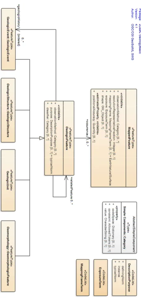
Figure 2-5 gives an overview of the GeologicFeature context diagram, expressed in UML as part of the application schema for GeoSciML 4.1. Core elements are present in the INSPIRE schema but hold more abstract concepts as well as links to different vocabularies. This thesis does not perform a more detailed analysis, since this is out of its scope. Of interest is simply to emphasise that the INSPIRE data model itself is an example of a more generalised model extension, retaining a standardised and interoperable structure, which remains compliant with underlying standards after modifications.
15
Figure 2-5 GeoSciML application schema segment – GeologicFeatue (IUGS Commission for the Management and Application of Geoscience Information, 2013)
16
2.4.2.
Data model formal description
INSPIRE data model Concepts and user requirements notation is defined as the INSPIRE UML profile. Unified Modelling Language (UML) is a modelling language designed for general purposes in software engineering. It conforms to a standard created and managed by the Object Management Group. UML syntax is a set of graphic notation techniques. It is used to specify, visualise, modify, construct and document the details of an object-oriented system under development. UML profiles provide means of adopting UML to certain areas of application. This is accomplished by extension mechanisms which allow adding new elements to the syntax in a way that facilitates the application of UML on a domain of interest, while avoiding the contradiction with the standard semantics. Profile is a collection of extension mechanisms (stereotypes, tag definitions, and constraints) that are applied to specific model elements (Classes, Attributes, Operations, and Activities). (Alhir, 2002)
Different UML profiles exist and are used to formally describe data models. On EU level ISO19103 (“Geographic information — Conceptual schema language“) UML profile is used. Furthermore, this model, used as INSPIRE UML profile is not conformant to the core UML specification, but extends it with additional elements. As it was mentioned earlier, GCM defines stereotypes used in the INSPIRE UML model. Thus, it carries UML syntax, but builds up new semantics on top of it.
In terms of harmonising regional spatial thematic data this means that there is a need for tools that support managing the INSPIRE UML model in order to formalise and extend the model according to user requirement. Furthermore, tools for encoding the model are needed to enable the transfer process and services for accessing data, namely for the support of GML for INSPIRE and specifically GeoSciML in case of the geology theme. Enterprise Architect, which was used in the examples described in section 2.3 on model extension, was proven as a compliant tool for model description in that sense.
2.4.3.
Schema and data transformation tools
Data harmonisation is a process of making data conformant with the referent characteristics that the target data model specifies. As a concept, Tamash (2012, p.12) defines harmonisation as a process that handles: syntax (that represents the data format that is covered by the referential standards), structure (meaning mapping of the source to the target data model schema) and semantics (as the meaning of the concepts in defined context, which relates to referential vocabularies).
Core phase of the harmonisation process is defining the structure, i.e. mapping of the data model schema. Östman & Abugessaisa (2014) define schema mapping as a three-phase process. The first phase is the adaptation of the source schema (which entails the identification of the semantically related objects by comparison of attributes, their meaning and representation), the second is schema mapping (finding transformation rules like data conversion, merge, split etc.) and the third phase is the schema transformation (extracting data from the source schema, transformation according to the mapping rules and loading into the target schema). Additional requirements towards the source data model and data set consider: specification of the coordinate reference system, measurement units and grid for data representation in a uniform manner; domain values consistency, which requires data and data type level conformance with the domain defined values; conceptual consistency, or conformance with the conceptual data schema on spatial objects and spatial object types level; metadata completeness. The stated transformation processes are to various extent automated through the use of the software tools that conform to the standards and requirements INSPIRE prescribes.
17
Available tools are discussed in Tamash (2012) and classified according to their scope of use, functionalities and usability. Core functionalities relate to the harmonisation process phases handling, including spatial data geometric and attribute management. These include, for example, coordinate systems reprojection, spatial transformation, managing data inconsistencies, merging data, data quality evaluation, formats transformation. For this thesis, robust and widely used software tool with INSPIRE user community and open source platform - Humboldt HALE is chosen.
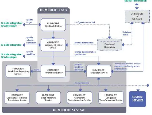
The Humboldt HALE software resulted out of the EU Humboldt project (Villa et al., 2012), focused on the integration of the EU level spatial data spread across domains and organisations. The project aimed to contribute to a higher level implementation of the European Spatial Data Infrastructure. Of interest for this thesis are the project activities in related to the technical enabling of the data harmonisation process. Project outputs in this sense provided the means for enabling documenting and harmonisation of organisations’ spatial data through: applications for specification of data conceptual schemas and schema transformation; services which enable interoperable use of data in conformance with INSPIRE requirements; transformation services for harmonisation purposes. Figure 2-6 depicts the structure of the Humboldt framework technical environment. All components are published as open public licences (GNU Lesser General Public License version 3 (LGPL v3)) and are freely available.
Figure 2-6 The HUMBOLDT Framework (The HUMBOLDT project, 2010)
Humboldt HALE stands for HUMBOLDT Alignment Editor and represents basically a tool for schema transformation. Other project tools cover modelling of schemas, processes, implementation and analysis of data transformation as well as transformation services etc. HALE Schema transformation tool enables mapping between different conceptual schemas through the capability of creating logical and semantically valid connections. These connections serve as the basis for data transformation.
18
HALE has an intuitive interface, a well documented and straight forward way of implementing functionalities. Its strengths are availability, compliance with INSPIRE, its spectrum of functionalities and intuitive usage.
2.4.4.
Validation of the data model
Schema and spatial data transformation are the main output of the harmonisation process. Thus, these are the subject of the validation against the requirements of the INSPIRE and underlying standards. This, in turn, defines the “what” and the “how to convey” regarding the harmonisation process quality control.
On a conceptual level INSPIRE GCM treats this topic in the segment Conformance testing as the interoperability quality control step. Namely, validation considers testing data specification requirements that refer to each conceptual data model class of the referential spatial theme. The formal procedure for testing conformance level is defined in the INSPIRE context with the Abstract Test Suite (ATS), which defines test cases. ATS is the formal basis for creating Executable Test Suite (ETS) as the concretisation of the ATS parameters which can be automated.
Tools used for formalisation of the data model, structuring and transformation into target data model are still being developed in accordance with INSPIRE requirements. During the research on this thesis, the European Commission Joint Research Centre released the official version of the INSPIRE validator, developed under ARE3NA, Action 1.17 of the ISA Programme (JRC, 2017).
Checking the conformance level as well as the extension of the target model implies that the resulting data set needs to be validated using the ATS. Depending on the spatial data theme available, there are automated testing tools like OGC Validator Test Suite for GML version 3.2. This tool can, at least partially, test the application schema, while complete testing requires further manual use of ATS/ETS. For example, for the theme geology, the OGC Validator Test Suite offers automated one third of the applicable tests.
Figure 2-7 Schematic on relations of INSPIRE IR and TG requirements and the Abstract and Executable tests “CC” stands for conformance class (Rinne, 2014)
Following the formal rules and using available software capabilities, INSPIRE conformance for the treated theme is validated against the target application schema, data formats and structure within the HALE software. Conformance to semantic and spatial requirements which ATS specify are further tested either with the OGC Validation Tool or by manual reference to the ATS.
19
2.5.
Western Balkans countries commons in context of spatial data governance
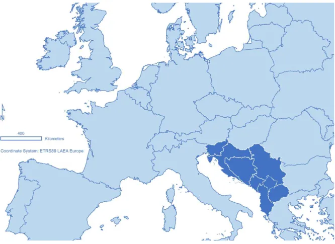
Introductory part of this thesis presented the positions of the Western Balkans (WB) countries. Here, their characteristics in relation to the INSPIRE Directive implementation is discussed as the background for considering a common interoperable spatial data model. Within the WB countries there are EU member states (Slovenia and Croatia), candidate countries (Albania, FYR Macedonia, Montenegro and Serbia) while others are potential candidates with a strategic orientation towards EU (Figure 2-8).
Figure 2-8 Western Balkans region countries
In relation to their EU membership status, obligations and activities in implementing INSPIRE differ from one WB country to the next. Member states are obliged to follow the INSPIRE roadmap and are have therefore reached a more advanced status of the Directive implementation. In FYR Macedonia, the INSPIRE Directive is already a part of the national legislation, while in other countries this process is started on a strategic level along with bringing the national development programmes into alignment with EU legislation as part of the EU integration process. The EU integration process is seen as the initiator of the activities in the domain of public data management in the WB region.
On the other hand, the process of political and economic transition of the region during the 1990s from socialistic to liberal market economy caused huge changes in domains like real property ownership (Cetl et al., 2013)from public to private owned property. This caused the involvement of large projects and international institutions’ loans in order to foster the economic progress of the WB countries. In such a constellation, as the first and experienced beneficiary and the most advanced institutions in the data managing domain, the National Mapping and Cadastral Agencies (NMCA) emerged as the drivers of the national spatial data infrastructures (NSDI).
20
Support to the process of NSDI development primarily comes from the EU pre-accession funds through implementation of projects like INSPIRATION – Spatial Data Infrastructure in the Western Balkans (Aleksic, 2013). INSPIRATION promoted and worked on establishing a means of coordination of NSDI implementations in order to meet the INSPIRE Directive requirements in the WB region. NMCAs played the central role here and showed the importance of an integral approach. Knowing the limitations of the resources in the WB countries and common institutional history, standards, organisational, infrastructural and market position, regional cooperation become a key factor of synergetic development and dispersion of activities for the mutual benefit (Cetl, Tóth & Smits, 2014). Observing the key segments of the NSDI in the WB region, background for building the common model was set up. Within the INSPIRATION project, the analysis of INSPIRE domains is conveyed following the INSPIRE reporting requirements methodology. Namely, major aspects of NSDI: Legal issues and funding, Coordination and organisational issues, Spatial data sets, Metadata, Network services, Interoperability and standardisation, as well as Use and efficiency were analysed for the WB region. Table 2-2 presents the outcome of the analysis in the form of a SWOT (Strengths, Weaknesses, Opportunities, and Threats) analysis table.
Table 2-2 SWOT analysis of the status of INSPIRE in the WB countries, adopted from (Cetl, Tóth & Smits, 2014)
Strengths Weaknesses
Organisational framework Legal framework
Existing reforms (e.g. LAS) NSDI strategies
NMCAs capacity
NMCAs cooperation in region (exchange of the experiences and lessons learnt)
Absence of funding models Lack of data sharing Licensing
Lack of interoperability Usage of standards Metadata catalogues
Cost/benefit analysis is missing
Opportunities Threats
INSPIRATION project
Stronger involvement in the different INSPIRE bodies (e.g. Maintenance and Implementation) Involvement of broader spatial data interesting community (private sector)
Accession of HR to EU (reuse of existing best practices)
Different funding opportunities (IPA, donors, etc.)
Joint projects (cross-border cooperation)
Lack of capacity on national level (other NSDI stakeholders)
Political changes (lack of political support) Lack of funding
21
The conclusion on the constellation of the INSPIRE Directive implementation in the WB and so far performed activities refer to the strategic and normative positioning of the Directive in the national approaches. Thus, the first important step, recognition and orientation towards adoption of the Directive has been done. Furthermore, there are current projects and active opportunities for funding and infrastructural strengthening of the WB NSDIs. These actualise the moment for establishing standardisation approach and establishing methodology in technical approach to data managing. On the other hand, some of the main weaknesses consider the absence of standardisation, problems in data exchange and lack of interoperability. In the long term, this situation is threatened by the possibility for change of the political direction which may sifgnificantly influence underdeveloped and dependent NSDIs. This thesis addresses the described situation by providing a common approach in data structuring as the model for interoperable exchange, considering a standardised approach and wider data usage. The thesis focuses on one of the themes to justify the methodology and opens the possibilities for better NSDI development region-wide.
2.6.
Overview of the experiences in data harmonisation process
Having defined the conceptual approach as well as the requirements that INSPIRE specifies, data providers across Europe have made significant progress in implementing the INSPIRE Directive. Constellation and issues in WB show which segments of INSPIRE are essential to be addressed first. This thesis already highlighted the key segments and discussed the model building concepts. This section gives examples of positive practice as the input for the practical realisation of the INSPIRE data model building and implementation concepts in Western Balkans.
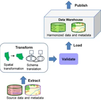
As one of the Europe’s most mature SDI, the Swedish environmental geodata and metadata compliance with INSPIRE specifications on the example of the European project Nature-SDIplus developed data is described in Hedefalk & Östman (2011). The goal was to examine all phases of the process of creating vendor independent and at the same time valid structure and syntax according to INSPIRE requirements. The paper presents a developed process bearing in mind costs of the process operations. As depicted in Figure 2-9,the existing data model for the source data was extracted in order to perform transformations (spatial and non-spatial) to specified INSPIRE formats, after which the resulting sets were validated and loaded into the target INSPIRE compliant database (Extract-Transform-Load or the ETL model). Data from the harmonised target model can be published and used further in an interoperable manner.
22
Figure 2-9 Overall harmonization approach (Hedefalk & Östman 2011, p. 32)
Core of the process that is of interest for this thesis is the transformation and data harmonisation. As emphasised in the paper, harmonisation considers resolving syntax, structure and semantics mismatch between compared data models. This process required comparison and identification of the elements from both data models. Further on, operations for the translation of one model to the other were defined, after which the actual transformation was executed.
As Hedefalk & Östman (2011) note, different phases of the harmonisation process require and have available automated solutions. The downside is the impossibility to have a fully automated process and consequently there is always a need for activities which demand manual work or decrease data quality. These are identified as the more costly processes. Thus, the divergence of the source data and the possibilities of the tools for automated processing (like coordinate systems transformation, merging, renaming, filtering etc.) determine the complexity of the transformation process. Hedefalk & Östman (2011) further discuss other phases of reaching interoperability, like validation of the schema and publishing various web-services in a standardised manner, which are out of scope for this thesis.
Experience gained in building up Swedish environmental data showed conceptual agreement on the INSPIRE guidelines for data model building as well as previously discussed theoretical concepts of model extension. What is important to mention is the practical implications that arise from the adopted process of data harmonisation. In that sense, extensive analysis of the source data, processes needed to transform the data and tools for performing the activities are the key segments for data harmonisation.
Another example of the spatial data harmonisation is the geological data in Portugal that was led by the need for more efficient and INSPIRE compliant data structure in digital geological maps production. The process described in Pereira et al. (2013) considered restructuring of the national model and transformation to extended INSPIRE theme geology model within the data producer’s -
Laboratório Nacional de Energia e Geologia (LNEG) - information system. The approach was as depicted in Figure 2-10.
23
Figure 2-10 Methodological workflow (Pereira et al. 2013, p. 131)
In order to have full INSPIRE compliance and satisfy Portuguese geological survey requirements, the underlying data needed structural change (Figure 2-10, Phase 1). The INSPIRE model needed extension in terms of modifying existing object classes, excluding certain elements and adding new object classes, code lists and attribute values (Figure 2-10, Phase 2). LNEG approach focused also on the integration of the new model with the existing production process (Figure 2-10, Phase 3). At that stage, the system was ready for production phase, GIS analytics, validation and map creation (Figure 2-10, Phase 4).
For this example the key segment was Phase 2. The Geodatabase design considered use of the database design software tool Enterprise Architect software from Sparx Systems in which the INSPIRE theme geology core model (described earlier in section 2.2) application schema was loaded and edited. Selected main types of the schema were loaded, coded value domains were also added and the coordinate system, compliant with the INSPIRE requirements, was defined. On top of the imported classes, a new class was added as the representation of the important features for the national geological maps comprehension. Beside the INSPIRE model ShearDisplacementStructure feature class, a new class Displacement was added to provide further information on the faults as the types belonging to the ShearDisplacementStructure. Several other class associations, attribute values and domain types were created. All modifications were altered using GeoSciML rules in accordance with the INSPIRE recommendations. Extended model was thus ready for data deployment from the existing model. Before the mapping between models took place, modifications in the source model were made in order to enable the transformation process in a more automated manner. Namely, a single table containing data about the geological map was split into two classes with type associations between them. Semantic harmonisation further required identification of the corresponding terms between Portuguese and English.
Following the described principles of INSPIRE model extension, experience from Portugal showed how specific needs for retaining essence of the national model, conformance with the existing GIS and taking most of the automation process were addressed.
Other similar experiences reveal projects for reaching data compliance with INSPIRE (like in GEORZ Lab & Research department, 2011) which considered creating fully compliant data through transformation of the existing data and storing it as XML in order to provide seamless and fast data publishing and serving, without intermediate processes between source data and targeted data model.