Deployment Software Review
Executive Development
BY: Gene F. Begnell
National Fire Academy Emmitsburg, MDAn applied research project submitted to the National Fire Academy as part of the Executive Fire Officer Program
http://www.lrc.fema.gov/ to learn how to obtain this report in its entirety through Interlibrary Loan.
ABSTRACT
The problem faced by the Orange County Fire Authority was a need to evaluate the current software programs available to assist in resource deployment decisions. The purpose of this research was to determine the features and capabilities of the most popular fire department deployment software available at the time. The descriptive research method was used to answer the following questions:
1. What deployment software was currently available to assist fire departments? 2. Which deployment software was being used by major urban/suburban fire
department in the United States?
3. What were the features and capabilities of the most used software programs? The procedures used in this research included literature review, interviews, surveys, vendor reviews and use of the actual computer software.
The results of this research indicated that only three “end user” software packages exist currently for the analysis of fire department deployment for the non technical computer user. While GIS programs do exist which allow sophisticated users to do many of the things that these programs do, the added value and knowledge of the program and programmers allows most fire professional to utilize the software with only minimal training.
The recommendations of this research project included the validation of the current software in use by the Orange County Fire Authority and acknowledgement of other programs that may have additional benefit to the Orange County Fire Authority in the future.
TABLE OF CONTENTS
Abstract ... 2
Introduction ... 4
Background and Significance ... 6
Literature Review ... 10 Procedures ... 21 Results ... 24 Discussion ... 37 Recommendations ... 40 References... 41
Appendix A (50 Largest Cities in U.S.) ... 42
Appendix B (Fire View Software Users) ... 43
Appendix C (DECCAN Software Users) ... 44
APPENDIX D (Survey of 50 Largest Cities) ... 45
INTRODUCTION
Computerization of the fire service, and life in general, has led to a large number of changes in how the fire service conducts its business. In the area of deployment modeling, this could not be more true. Ron Coleman states, “100 years ago the way we displayed our fire protection problems was on Sanborn maps. Drawn by hand, building by building, block by block, they were eventually abandoned because they were too labor intensive. Today we need specific information on our fire problems more than ever. And we have a new tool: GIS. Just like we no longer fight fires with steamers, we shouldn’t be using century-old techniques to define our fire problems with a paper and pen. E-fire means using your computer to achieve excellence in fire planning” (Johnson)
Deployment is based on numerous complex issues. Some of these include fire flow (required and available), occupancy or use, frequency of occurrence for incidents, response times and environmental factors. Russ Johnson, Public Safety Industry Manger for ESRI states it very well:
Traditional planning methods require the use of numerous maps, reports, tables, and historical records. This data is often found in a variety of different locations and formats and requires a great deal of time to acquire, prepare, and formulate into a useful format. Resultant deployment plans are often completed, implemented, and shelved. Deployment
planning in the traditional sense is more of an event than an ongoing process.
Geographic information systems (GIS) allow deployment analysis to
become a process rather than a periodic event. Fire officers can view all of the data necessary to analyze deployment in one view. Data can be
added, subtracted, or modified with a click of a mouse. Alternative plans can be created, analyzed, and modeled by fire officers using GIS. Once a GIS database has been created, deployment analysis can be reviewed and updated at any time with little effort.
Although computerized mapping systems have been around for many years, recent improvements have made GIS software available on the desktop and on laptops. GIS applications developed specifically for fire departments provide tremendous functionality through a user-friendly interface. GIS software can now be used by non-specialists to improve planning, analysis, and response. These tools offer managers the ability to eliminate much of the guesswork that has been the norm in tasks such as siting stations or deploying apparatus. (Johnson 2001)
Deployment modeling can be done without computers but in a large or complex delivery system, without computers, it would simply be too overwhelming of a task. For fire service personnel who are not advanced computer users or programmer, the task would not be any easier if they did not have a program capable of assisting them in the complex nature of the analysis. This is the job of deployment software.
Problem Statement
The problem is that the Orange County Fire Authority needs to evaluate the current software programs available to assist in resource deployment decisions. Purpose Statement
The purpose of this research is to determine the features and capabilities of the most popular fire department deployment software available at this time. The
descriptive research method was used to answer the following questions:
A. What deployment software is currently available to assist fire departments?
B. Which deployment software is being used by major urban/suburban fire department in the United States?
C. What are the features and capabilities of the most used software programs?
BACKGROUND AND SIGNIFICANCE
The Orange County Fire Authority is in the middle of a strategic planning process. This process was undertaken after a five-year transition period when the County Fire Department became the current Fire Authority. No longer a part of the Orange County governmental structure, the Fire Authority is a “stand alone”
organization. It is solely responsible for all of its own needs. This includes personnel, purchasing, fleet management, financial services, facilities and all other functions typically done by other parts of government for most fire department.
The Fire Authority serves 22 cities and the unincorporated areas of Orange County. The Authority is governed by a Board of Directors consisting of one
representative from each city and two representatives from the County. Day-to-day decisions are delegated to a seven person Executive Committee elected from the entire board.
The Fire Authority hired a consulting firm, Emergency Services Consulting Group (ESCG), to facilitate the current strategic planning process. In the ESCG’s review of the Orange County Fire Authority’s current deployment modeling software, they concluded the following:
“As a general observation based upon the demonstration provided by BC Begnell, it should be noted that there was nothing notably unique about the ADAM software which set it apart from a number of
Geographical Informational System (GIS) applications available from both private vendors and as public/user group shareware. When considering the purchase of such software, a routine review of a variety of applications is suggested”. (ESCG 2000)
The validity of the statement above and the review suggested is the genesis of this research project.
Present Impact
The Orange County Fire Authority is a current user of modeling technology. It has used this technology in several studies over the past five years. As with any technology, it is good to stop and take a look at the state of that technology on occasion. The findings of the consultant in the strategic planning process currently underway has caused this occur at this time. The Fire Authority is at a crossroads and will expend millions of dollars in the next few years on fire stations, both new and
reconstructed. Since these facilities are intended to last over 40 years, they need to be in the right place.
Complete with the planning of new fire stations, the Fire Authority is studying its volunteer firefighter program and support equipment staffing/location. All of these issues have deployment components. Each needs to be analyzed, not only by its self, but also as a part of the larger more complex deployment of the entire system. With over 60 fire station and 100 first line responds vehicle, it is impossible to take any single issue out of the fabric of the overall deployment and make a decision. All decisions have at least some impact on the next.
Future Impact
While it is impossible to predict the future, it is possible to be prepared for it. The current strategic planning process will produce a new “Standards of Cover” for the Orange County Fire Authority. This along with the possible implementation of NFPA 1710 will make the need for deployment modeling critical to the planning process. The Orange County Fire Authority needs to know that it is using the appropriate technology to make these critical decisions. This research will provide the facts necessary to decide if additional modeling software is needed.
Relevancy to the Executive Development Class
This research project was completed in accordance with the applied research requirements of the National Fire Academy’s Executive Fire Officer Program. The problem addressed by this research paper related specifically to Unit10 of the
Executive Development course, titled “Service Quality/Marketing”. In this unit of instruction, students were introduced to the importance of emulating excellence in government. Specifically, the lessons that can be learned from award-winning
agencies. One of those lessons is to use information technology to improve services to citizens. Deployment software is cutting edge technology for the fire service with a direct benefit to the citizens in improved service at the best possible cost. This project will showcase the current state of that technology.
LITERATURE REVIEW
The literary review conducted in this study provided a considerable amount of information pertaining to deployment software in its current state. Before reviewing the specific deployment software available today, it may be helpful to understand the roots of this software.
The Wichita Fire Department commissioned PTI to develop a fire service computer model back in 1973. The model was very labor intensive and required thousands of staff hours to develop before a single study could be performed. Many travel assumptions were entered to accommodate the lack of computer power of the 70's era mainframe computer. A Canadian product called Fire Router appeared in the 1980's. This model used the same basic methods that the PTI model used, but added crude black and white graphics printed output. In 1992, the FLAME software was developed that took advantage of PC's capabilities and the U.S. Census maps. This new model reduced the cost of computer modeling such that even the smallest of fire departments could afford to perform their own computer modeling. This new software no longer reduced the scope of the study as was required by previous software. (Bode)
In addition to the advances made by FLAME and other computer software designer, the computer industry as a whole began to produce hardware and software capable of performing complex analysis with map interfaces. These interfaces, often referred to as GIS (Geographic Information Systems) have become the standard in the
mapping and data analysis fields for many function in the fire service today. For example, for a fire department to get accredited by the Commission On Fire Accreditation International, one of the key self-assessment tasks it must complete is review its deployment by applying the "Standards of Cover" (SOC) process. In fact, this task has been designated as a "core competency" to be met by departments seeking accreditation. The eight parts of the SOC processes, as detailed in Fire Chief Magazine (Gary 2001) are:
• Review existing deployment
• Define community outcome expectations
• Perform community risk assessment
• Complete distribution study
• Complete concentration study
• Evaluate historical reliability
• Evaluate historical response effectiveness
• Perform overall evaluation
While this analysis could be done without a computer, it would be difficult and time consuming to do so. Chief Stewart W. Gary, Livermore-Pleasanton (Calif.) Fire Department states, “… computer programs have really made the soc process more powerful and less labor-intensive. Many departments already use a geographic information system to provide run maps and dispatch system geo files. Many such systems will also do credible travel-time analysis over the local street network, which is far more useful than drawing station area circles or diamond areas on a map. Some firms have built software packages that combine geographic mapping with dispatch
incident data analysis that allow all the study steps to be readily preformed”. (Gary 2001) Without deployment software, it may be nearly impossible to adequately analyze the data for basic tasks like those in the accreditation process.
What deployment software is currently available to assist fire departments? In conducting research for this project, a search for any and all deployment software available was completed using fire service publications, the Internet, the NFA Learning Resource Center and GIS vendors. This resulted in the following software programs being located:
FLAME (Bode Research Group 1997) FireView (The Omega Group 2001) ADAM (Deccan
CadAnalyst (Deccan)
Also found were two GIS platforms which are used in some of the program above but can also be used without additional software by the advanced user:
ESRI (ArcView, ArcInfo, ArcGIS components) MapInfo
FLAME (Bode Research Group)
John Bode (developer of FLAME) was a part of the development team in Wichita in 1973 that developed the PTI model that was used for many years across the United States. FLAME includes all street segments available in the map base when computing
a study. It was designed for that fire departments, using only one staff member, could produce meaningful graphical reports in a few hours or days. The model has evolved over the years to become a highly reliable and proven method to communicate the needs of the fire and medical services. FLAME was written specifically for the fire and medical service and produces reports that truly illustrate the ability of an emergency agency to mitigate the emergency incident. (Bode 2001)
FireView (The Omega Group)
The Omega Group has the FireView software that is a customized easy-to-use interface for the mapping, analysis and reporting of Fire/EMS data. The capability of FireView to integrate Fire/EMS data with ArcView GIS software and geographic
boundary layers enables public safety personnel to better manage operations through analysis and reporting. FireView displays a GIS interface to existing CAD and RMS databases to automatically import data at scheduled intervals, providing Departments with the most recent data to analyze. (The Omega Group 2001)
Deccan International (Family of products)
According to Deccan, “CAD Analyst and FireEMS ADAM software applications are the tools of choice of fire departments performing the tasks involved in the SOC process. These applications are “turnkey”, in that they are delivered to each fire departments complete with processed CAD data and a current deployment scenario. As a result, all users have to do is "turn the key and drive", i.e., directly perform the analysis needed for the SOC tasks and derive necessary insights. As a result, departments are saved the tedious and time consuming work of downloading CAD
data, applying GIS etc., and instead can focus on the tasks at hand and setup and complete the SOC process”. (Deccan)
More specifically, CadAnalyst is a retrospective view of actual CAD data within the SOC performance measures defined by the user. ADAM then, using the outcomes of the data, allows the user to relocate resources, stations and personnel in order to see the impact of the decisions.
GIS Mapping Software
ESRI (ArcView, ArcInfo, ArcGIS components) and MapInfo are both leaders in the electronic mapping industry. These programs offer all of the basic features of the software described above. In fact all but FLAME utilize one or more of these programs as the basic operating system for the application. These programs can be used without the overlay software by the experienced user, if they have experience in deployment modeling and computer programming.
One such program was developed for the city of Regina, Canada. In order to accomplish the modeling task, the city formed a multidisciplinary team from the fire department, information systems and several manufactures/consultants to complete the complex detailed need to make the calculation. (Figueroa and Kartusch 2001) Several other agencies had similar experiences but will not be detailed here.
Which deployment software is in used by major urban/suburban fire department in the United States?
In reviewing the statement of the vendors regarding usage of the software packages, we find a wide range of utilization for all three packages:
FLAME (Bode Research Group)
FLAME has been used extensively by fire chiefs, city administrators, employees, unions, and consultants over the past few years to address deployment issues. The FLAME fire station location and mapping program is already installed in hundreds of progressive fire departments across the nation. FLAME is in use by many fire districts having from only a few fire stations to districts with over one hundred fire stations. The software has also been used internationally in such countries as Moscow, Melbourne, Johannesburg, Sydney, and Canada. (Bode Research Group 1997)
FireView (The Omega Group)
FireView is the newest of the software packages detailed in this report. It is being used in approximately 21 locations in the United States. A list of the users can be found in Appendix B of this report. (The Omega Group 2001)
Deccan International (Family of products)
The Deccan software is currently in use in over 40 locations in the United States, and Canada. A list of these users can be found in Appendix C. (Deccan)
In addition to the software packages, both the ESRI and MapInfo products are in use in many if not most larger governmental agencies in the United States. On any given day, more than 1,000,000 people around the world use ESRI's GIS to improve the way their organizations conduct business. (ESRI 2001).
What are the features and capabilities of the most used software programs?
The deployment software field is as complex as any. Each of the software developers has made an effort to find a place in that market. However, all of the
software has some basic features and capabilities common to all three. A few of these feature and capabilities include:
• Geo-referencing of incident data
• View and adjust fire station response districts
• Time and distance measurements and calculations
• Total time for people to arrive on the emergency scene/Fire fighter distribution
• Equipment Distribution
• Dispatch modeling and analysis
• Fire station dispatch order sequence list
• The ability to model mutual aid scenarios
• The ability to analyze functional consolidations
• Overall average response time
• Arrival time for multiple unit types
• Geo-coding and display of points of interest/reference points
In addition to these capabilities and features, each software package offers some unique abilities of its own.
FLAME (Bode Research Group 1997)
FLAME features as described by the applications literature:
• Calculated total street miles in each response area
• Display of travel speeds (also available in FireView)
• FLAME can instantly display the best path from any street to the closest fire station.
• Automatically adds distance and speed information to new street segments and places them in the program for analysis.
FireView (The Omega Group 2001)
FireView 2.0 features as described by the applications literature:
• Find a route between two addresses
• Incident data updated daily
• Wizard-driven routines and customizable dialogs capable of querying the incident database.
• Inspections/Incident clusters/Arson Suspects Tracking in GIS.
• Place known hazmat locations on the map
• Create a focused map of a fire district or other geographic area
• Displays travel speeds (also available in FLAME as an option)
• Hot spot or incident cluster analysis
• Calculates percentile response performance to various zones within the service area.
Deccan International (Deccan)
CAD Analyst features as described by the applications literature:
• A Workload and response Performance calculator that lets a user specify the specific days-of-the-week, times-of-the-day, seasons of the year, and incident type groups of interest. CAD Analyst then extracts the incidents during that time period and of that type and displays their density thematically in a map. (FireView has a similar feature)
• Average performance buttons that let a user look at specific response type performances such as average first unit, first EMT, first paramedic, second engine on scene. The performances are thematically displayed in a manner that green means acceptable performance and red indicates unsatisfactory performance.
• Percentage performance button that displays % of incident meeting performance targets thematically.
• Zoom button that lets a user zoom into a particular area of the response area, and views all the incidents in that zone. Each incident is colored coded as stars. The user can click on a marker to get all details on that incident including incident number, date of incident, location, etc. (FireView has a similar feature)
Fire/EMS ADAM features as described by the applications literature:
• Enables the user to specify alternate fire apparatus location scenarios by merely “dragging” apparatuses with a mouse from one location to another.
• For the above scenarios, automatically recalculates and graphically displays response performance.
• Calibrates software so that response performance projections for the current location scenario closely matches actual recorded performance.
• Automatically color-codes the service area according to hazard type and whether response time goals are being met.
• Estimates call-to-scene times under new location scenarios based on past history only, not assumptions on related items such as travel speeds.
• Estimates apparatus run-loads and apparatus availability under new location scenarios based on historical distribution of incidents.
• Calculates percentile response performance within the service area for projected performance. Performance is calculated and displayed at the system, agency and district level. An example of percentile performance is “Percentage of incidents with response times less than 8 minutes”.
Literature Review Summary
A thorough review of the literature on the subject of deployment modeling software has produced only three software packages which are capable of being used by the “end user” without a great deal of knowledge or training. These software
packages, FLAME, FireView and the Deccan software (CADAnalyst and ADAM) are the only software that the review has found that are currently in use in more than one
location. Some custom applications running on ESRI and MapInfo software were located but all were specific to the location used.
Each of the three software packages detailed in the literature review is unique and yet has many similarities. All have the same stated intention, that being to assist the user in decisions on the placement of station, apparatus and personnel. All of these programs are based in GIS foundations. All use map interfaces to display the results. The differences are great too with each package offering specific functions not offered
PROCEDURES
The descriptive research method was utilized to gather information on
deployment software available and in use by fire departments throughout the United States. Information was acquired through several different mediums including
interviews, surveys and the actual use of the software by the researcher. The process was as follows:
1. Conduct a search for any fire department deployment software in books, periodicals, Executive Fire Officer (EFO) Applied Research Papers, codified references and on the Internet.
2. Survey the 50 largest cities in the United States regarding deployment software use.
3. Interview the principles of top three software companies used by the 50 largest cities.
4. Acquire copies of the software for the top three software packages available to Fire Department (except custom software developed by specific fire departments for internal use and standard GIS programs or platforms) 5. Install and use each of these software packages to determine the features
and capabilities of each.
6. Complete a side-by-side description of the features/capabilities of the three software packages.
7. Send results of comparison to software vendors to allow input on errors or omissions to data.
8. Compile results into easy to use format for future decision making.
Survey of 50 Largest Cities in the United States
The reason that this study uses the 50 largest cities in the United States as the basis for the survey is that this was the only focus group of fire departments that the researcher could find that was capable of being validated by larger research. This list is complied by the United States Census Bureau. An effort was made to acquire a
validated list of the 50 largest fire departments in the United States but a valid list could not or would not be provided by an agency or group within the timeframes needed for this study. After four weeks for work, the largest cities survey field was used. Six fire departments did not respond to the survey or follow-up requests for information. Limitation and Assumptions
This is preliminary research designed to investigate the software that is available for use in the marketplace today. This research is not a critique or product evaluation of the software. The research is in response to a specific need. Proper evaluation of the software would take more time and expertise than is available for this study.
It is assumed that all responses to survey and interview questions were answered honestly and that the person had the knowledge to answer the questions being asked.
Definition of Terms
Deployment – Webster defines this as, “to spread out, utilize, or arrange
especially strategically”. As applied to this study it refers to fire stations, apparatus and personnel.
GIS – Geographic Information System - An organized collection of computer hardware, software and geographic data designed to capture, store, update,
manipulate, analyze and display all forms of geographically referenced information. GUI – Graphic User Interface – a means of interaction with the computer where the user will point and click on objects rather than type or use keystroke to control the actions of the computer.
Standards of Cover (SOC) - a term adopted from Western Europe and other countries where there are national standards for fire service deployment. A standard of cover policy describes the deployment “coverage” for a given community or area.
RESULTS
The research for this project produced a variety of results. A large amount of these results are from interviews and the use of the actual software programs. The nature of this type of result does not lead its self to statistical analysis. Except as noted, all results indicated in this section are from the researcher direct observations of the software.
Research Question 1: What deployment software is currently available to assist fire departments?
Utilizing the survey of the 50 largest cities in the United States (Appendix D) it was determined that while a number of custom applications are in use today, no two agencies in the survey are using the same custom program. In interviews with the principles of the software vendors detailed in the literature review, they confirmed that they have had the same experience with the variety of custom programs around the county.
Specifically software packages found in the search: FLAME
FireView ADAM CADAnalyst
ArcView - Custom applications ArcInfo - Custom applications MapInfo - Custom applications Landtrack – one location
ESRI Network Analyst
Research Question 2: Which deployment software is being used by major urban/suburban fire department in the United States?
In completing the survey and interviews, it was determined that the major urban and suburban fire department, from the fifty largest cities in the United States, are not actually using any deployment software. Of those who are using deployment software to assist in deployment analysis, the programs indicated in the literature review were the only ones found.
Of the fire department using deployment software, FLAME has the widest
distribution. According to John Bode, “FLAME has been used to study fire and medical coverage on 1,052 counties to date. FLAME is the most popular fire protection
modeling software and the most reasonably priced”. (Bode)
Ranking second would be the DECCAN Software (Appendix B) with 41 current users and several more in the process of deciding or purchasing the software. The DECCAN Software is actually more than one program and each site may not have purchased all of the programs. Still, this represents those who are using at least one of the DECCAN programs.
FireView is the newest of the three programs. According to Milan Mueller, president of the company, they have approximately 30 sites in various stages of use or acquisition. (Mueller)
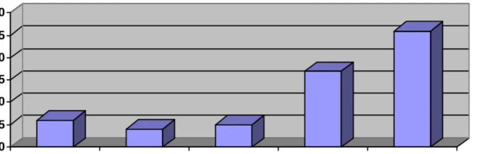
In looking at the 50 largest cities in the United States we find that the large majority of these cities are not using software to assist them in making deployment decisions. Of the 50 department, 46 responded to the survey. Within the 46
departments, six are using the Deccan software, four use the FireView software and five are using FLAME. Some departments are using more than one of these software packages. Seventeen departments are using custom software built by or for that department using criteria and specifications derived from the knowledge and talent of the user organization; no two departments are using the same customized software. Of the 46 departments, 26 are using no software at all to assist them in deployment
decisions. The figure below shows the relationship of departments using deployment software.
Figure 1. 50 Largest Cities Fire Departments Using Deployment Software
0 5 10 15 20 25 30
Deccan FireView FLAME Custom None
Research Question 3: What are the features and capabilities of the most used software programs?
In this research project, the actual software for each of the three companies was run to develop a list of features and capabilities for each. The results of that effort are shown in Appendix E (side-by-side detail). In general terms, the results are:
The FLAME product is simple and effective. It is easy to use, and once the setup is complete, it takes very little training to operate. The software is only designed to look at the travel time aspects of deployment, in terms of the scenarios that can be
developed. The more sophisticated user will be able to use this software to completed basic deployment analysis.
The FLAME program has ability to geo-reference calls for service and show graphically where these calls are in relationship to the fire stations and apparatus. At the same time, the area covered for a selected resource (2nd arriving unit for example) can be displayed over the incident data
FLAME can produce maps of the first due companies.
It also calculate travel times to various points on the map from the fire station locations and displays this information for the user.
The FireView product is a very good tool for looking at not only the time and distance issues but also the data behind the responses. This software has the ability to query the databases. Completing analytical task such as finding the locations of all of the calls outside of the second standard deviation is a simple and quick query. Additionally, the program tracks issues such as arson suspects and inspections in order to complete more complex tend analysis. The FireView product uses the street network to complete the time and distance modeling in a manner similar to FLAME but has the added advantage of the GIS software is runs under to give it additional capabilities not found in the simpler program.
FireView has the ability to graphically illustrate trends such when or when the agency is having certain types of calls.
FireView can also be used to examine problem areas such as false alarm activity.
Coverage Maps can be produced to show the area that a fire station will provide service. This can be used to analyze such things as the four and eight minute response areas in NFPA 1710
FireView can produce density maps showing where the calls for service are
Queries can be performed using the wizard driven dialog box or for the more sophisticated user the advanced dialog box
Reports can be produced in tabular or graph format.
The FireView software has features not enjoyed by the other two programs with respect to the query abilities and additional databases for non-deployment activities.
The program allows the user to be functional with a very limited amount of training and effort.
The DECCAN family of products is the most complicated and offers the most powerful analysis from a deployment aspect. Specifically in the SOC (Standard of Cover) aspect, no other program on the market today offers the user this type of analysis and user friendly output without being a computer technician.
The DECCAN software has the ability to show performance in both averages and fractal performance. Additionally, the software produces results at the system, agency and grid or district level.
without the vendor. All of the updates to data/maps and changes to the assumptions of issues, like travel speed, must be accomplished by the vendor. The reason is the complexity of the software and data. The software is simple to understand. Input in the CADAnalyst program are simply a choice of options.
The CADAnalyst program also has a nice feature that allows the user to see the detail of the calls in the analysis
The user can then actually look at the specific calls within the area.
Within the ADAM software, the basic operation is to drag and drop. While some changes are made it text boxes, the majority of the operation is done with the mouse.
Outputs on the DECCAN software are just as easy. The user get both graphic and text outputs on the same page. Overall system answers are easily viewed in the thematic maps and the detailed answers are available within the text.
The DECCAN software is the only software that actually calculates the workload and probability of availability into the performance outputs. The software is driven by actual data. All modeling in ADAM is done based on assumptions compiled in the CADAnalyst program using actual call data. One of the most important aspects of the DECCAN software is the validation loop provided with the two software programs. When a deployment decision is made using ADAM, after a short period of time, the actual data from that change can be analyzed in CADAnalyst to see if the projected performance matches the actual performance. The model can be adjusted if necessary
DISCUSSION
All three of the software packages described in this research are valuable tools in the deployment analysis effort. Each tool (software package) has a place and some unique abilities not enjoyed by the other software packages. In conducting this
research, it was noted that all of the claims made by the vendors in the literature review with respect to the abilities of the software were found to be true.
FLAME is a good basic tool for almost any department. Given the cost of this software, it is definitely the most cost-effective software. It has some limitations in terms of GIS based maps and the lack of analysis for segments other than the travel time, but it is good solid software with a long history of providing the user benefit at a low cost.
FireView is new and exciting software. It does a number of things that none of the other programs do. For example, the additional databases that track inspections or arson suspects. It is unlikely that the other programs will do this. FireView being a product of the same company that does CrimeView has an advantage in this area that will give them this ability easily. If your needs are straight deployment and standards of cover, the additional feature do not offer a great deal. The query feature and wizard is a very good one. This feature alone is worth the price of the program for users who do not have analyst on staff. The feature allows the user to look deep into the data to see why performance is what it is. For the more advance user, this feature allows a level of analysis within the data that is better than anything on the market today.
The DECCAN family of products is the most sophisticated deployment software available on the market today. This is not to say that someone with knowledge of GIS software, deployment calculations and statistical methods could not complete the same
work. The reality is that most fire departments simply to not have this type of person available to them. The DECCAN software has several features that make it
outstanding. One of the best is the output in graphics that are easy to understand by the politicians and non-fire people that must be educated on the reason and data behind the deployment decision each fire department must make. The DECCAN software is not for everyone. Smaller departments would not see the return on the effort in the analysis. For example, if you only have three fire stations with three engine and truck, your ability to change the deployment for effective fire force is limited at best. Some value could be derived but maybe not enough to complete the work and spend the money on this high level analytical tool. When it comes to completing the SOC (Standards of Cover) analysis, this software shines. It does all of the complex
calculations, leaving the user to concentrate on the decisions and not the software or data.
Deployment software is still a developing area. As noted in the results section, the majority of the larger fire department as still not using software to assist them in making the deployment decisions. Many have tried and true standards that they use for station locations that are not affected by workload, street networks or topography. The use of deployment software may not have any affect on system where the technical nature of the deployment is not the over-riding influence in the final determination of the location, staffing or configuration of the apparatus. But, for the departments that do want to take all of these factors into considerations and find the most effective and efficient delivery system available, the deployment software is certainly one of the best tools for the job.
The genesis of this report was to take a look at the currently software available in the deployment field and see what is there. This has been accomplished and the field is narrow but actually filled with some very good products. The contention that there are a great number of products that can do deployment analysis is somewhat misplaced. While there are number of GIS product on the market that can do some aspects of time and distance modeling, all of these require a technician who can run this software. Within the deployment field, the three software packages available all have a place in the market. The OCFA has two of the products already (FLAME and DECCAN) and might well consider acquiring the third program. Each has a place and fills a need.
RECOMMENDATIONS
The results of this research indicated that only three “end user” software packages exist currently for the analysis of fire department deployment for the non-technical computer user. While GIS programs do exist which allow sophisticated users to do many of the things that these programs do, the added value and knowledge of the program and programmers allows most fire professional to utilize the software with only minimal training.
This research has laid the appropriate groundwork for future decision making on deployment software for the Orange County Fire Authority. As suggested by the
consultant group completing the strategic plan, a thorough review of the available
choices has been made with respect to features and capabilities. The conclusion is that while custom programs and GIS software may be available in many forms, only the software programs detailed in this report are available for use by the average fire service manager without extensive training. Each of the programs offers value to different types and size fire departments. Each program has unique capabilities that may be useful even if an agency already has one or more of the other programs. This research has produced a quick reference (Appendix E) for the fire departments to decide which of the program might best meet the needs of that particular department.
REFERENCE LIST
Bode, John, President, Bode Research Group, (personal communication, August, 31, 2001).
Bode Research Group. (1997). New Fire Resource Model. [Brochure]. Bode, John: Author.
Deccan Web site, Deccan International, (http://www.deccanintl.com) Emergency Services Consulting Group (ESCG) (2000), a subsidiary of the Glatfelter Insurance Group, FIRE AND EMERGENCY SERVICES EVALUATION (Orange County), Volume One, Wilsonville, Oregon, p. 14.
Figueroa, Roberto and Kartusch, Michael, Geospatial Solutions, Flaming to the Scene: Routing and Locating to Get There Faster, retrieved January 30, 2001, from the World Wide Web: http//www.geoinfosystems.com/1100/1100fire.html
FireView Web site, The Omega Group, (http://www.theomegagroup.com) FLAME Web site, Bode Research Group, (http://www.brgproducts.com) Gary, Stu, (2001, February), System of cover, Fire Chief, 34-35.
Johnson, Russ, GIS For Your Specialty, GIS: A Powerful New Tool for Fire and Emergency Services, Retrieved August30, 2001 from the World Wide Web:
http://www.gis.com/specialty/government/gisforfire.html
Mueller, Milan, President, The Omega Group, (personal communication, August, 31, 2001).