Combined High Resolution Laser Scanning and Photogrammetrical Documentation of the
Pyramids at Giza
W. Neubauera, M. Doneusb, N. Studnickac , J. Rieglc
aVIAS-Vienna Institute for Archaeological Science, Franz Klein-Gasse 1/III, 1190 Vienna, AUSTRIA - [email protected]
bInstitute for Prehistory, Franz Klein-Gasse 1, 1190 Vienna, AUSTRIA - [email protected] c
RIEGL Laser Measurement Systems, Riedenburgstr. 48, 3580 Horn, AUSTRIA - [email protected] , [email protected]
KEY WORDS: World Heritage, Archaeology, GIS, 3D Laser Scanner, Digital Documentation ABSTRACT
The aim of the Scanning of the Pyramids Project 2004 was to apply and test latest state-of-the-art terrestrial laser scanners combined
with a calibrated digital camera for high accuracy, high resolution and long distance topographic scanning in archaeology. The monuments selected for the first campaign are the Cheops Pyramid and the Sphinx. The data form the basis for a detailed three-dimensional modelling of the monuments to show and to test the instrumentation as a general-purpose tool for the documentation and monitoring of standing monuments. This has to be seen as a primary data base for the preservation of the monuments investigated by the method. The combined sensor of a high-performance long-range laser scanner and a calibrated and orientated high-resolution digital camera provides scan and image data. This data can be automatically or semi-automatically processed to generate products such as textured triangulated surfaces or orthophotos with depth information. All the tools developed for image analysis, such as edge detection or signal detection, can be used for direct extraction of 3D content from the combined image data and scan data. The collected data therefore provide a solid and large data base for any further analysis related to scientific problems of the construction, the destruction and decay of the World Heritage Monuments. The data collected are an important extension to the Giza Plateau Mapping Project, and will be made available to the scientific community.
1. OBJECTIVES OF THE PROJECT
The Scanning of the Pyramids Project 2004 was invoked as a
major scientific project by the Austrian Archaeological Institute Cairo and VIAS-Vienna Institute for Archaeological Science in cooperation with the Egyptian Supreme Council of Antiquities,
Dr. Zahi Hawass. The project was directed by Prof. Dr. Manfred Bietak, Director of the Mission and Dr. Wolfgang Neubauer, Field Director. The aim of the project is to apply and
test latest state-of-the-art terrestrial laser scanners produced by the Austrian company RIEGL LMS for high accuracy, high
resolution and long distance topographic scanning suited also for archaeological applications.
Laser scanning has already shown its outstanding advantages in acquiring 3D information on an object’s surface in many archaeological applications within the past few years (Doneus et al., 2003; Doneus & Neubauer, 2004; Doneus & Neubauer, 2005). However, the archaeologist is not only interested in geometrical information, but also in additional information on the object’s surface, i.e. the texture. Integrating a high-resolution calibrated camera into a laser scanning system provides a very efficient, convenient, and powerful system for an automatic generation of accurately textured high-resolution 3D models. Thus, the versatile hybrid instrument corresponds ideally to architectural, topographic and archaeological requirements.
The data collected in this project form the basis for a detailed three-dimensional modelling of the monuments to show and to test the instrumentation as a major general-purpose tool for the documentation and monitoring of standing monuments. This has to be seen as a primary data base for the preservation of the monuments investigated by the method. The monuments selected for the first campaign are a monumental building, the Cheops Pyramid and a monumental statue, the Sphinx, two
types of monuments typical for Egyptian heritage. Table 1 summarizes the key specifications of the system used for the 3D documentation of the Cheops Pyramid and the Sphinx.
The three main objectives of the Scanning of the Pyramids project are:
- The collection of high resolution and high accuracy topographic data for the creation of a digital elevation model of the Giza plateau,
- a three-dimensional documentation of the Cheops Pyramid and the surrounding, and
- a three dimensional documentation of the Sphinx.
The data collected are an important extension to the Giza Plateau Mapping Project, and will be made available to the scientific community.
2. METHOD
For this research project we used a terrestrial 3D Laser Scanner
RIEGL LMS Z420i combined with a calibrated Nikon D100
digital camera (Fig. 1). This hybrid sensor is composed of a high-performance long-range laser scanner with a wide field-of-view and a calibrated high-resolution digital camera firmly mounted onto the scanning head of the laser scanner (Riegl, 2005). As for every image taken with the camera the position and orientation of the camera is measured with high accuracy within the scanner's own coordinate system, scan data and image data can be combined in a straightforward way without the need of user interaction. The system is complemented by a data acquisition system based on a standard laptop. For convenience in numerous applications, both sensors, laser scanner and camera, are connected to a WLAN-Box, so the data acquisition PC can be setup remotely.
Data acquisition, sensor configuration, data processing and storage are done by the companion software RiSCAN PRO. The whole system is battery powered and highly portable, but yet robust and operable in a wide range of environmental conditions.
Hybrid Sensor RIEGL LMS-Z420i with Nikon D100
Measuring range up to 800 m
at target with 80 % reflectivity Ranging accuracy 10 mm (single shot)
Beam divergence 0.25 mrad Measuring rate 8000 points/sec Scan range 0 to 80 deg vertically,
0 to 360 deg horizontally Scan resolution up to 0.004 deg Camera chip 3008 x 2000 pixel used Camera lenses 20 mm, 85 mm focal length Camera field-of-view 80 deg x 58 deg with 14 mm lens
Table 1. Key specifications of the system.
The characteristics of the most powerful instrument of the
RIEGL LMS scanner series, the LMS-Z420i, are: its narrow
beam divergence, its wide operating range, and its excellent single-shot accuracy. As a consequence, the raw scan data provide a precious basis for various post processing techniques. The time-of-flight laser measurement technique employed, allowing long range performance and reliable data acquisition even for locations difficult to access, is perfectly complemented by the photogrammetric method (high pixel density, hence definition and vectorisation of edges and high accuracy of details). The hybrid sensor provides geometry data from the laser scan and image data from the camera. These data can be automatically or semi-automatically processed to generate products such as textured triangulated surfaces or orthophotos with depth information. Additionally, all the tools developed for image analysis, such as edge detection or signal detection, can be used for direct extraction of 3D content from the combined image data and scan data. The collected data therefore provides a solid and large data base for any measurements related to scientific problems on the construction, the destruction and decay of the World Heritage Monumentsas well as the plenty structures in the surrounding.
3. DATA ACQUISITION
To carry out the project it was necessary to set up an array of retroreflectors to be used as control points for georeferencing
the data collected by the 3D Laser Scanner. These control points have been surveyed using a Leica TCR703 total station in a
local coordinate system set up during the survey. This local system will be transformed into the coordinate system set up by the Giza Plateau Mapping Project. The control points are used to link the single scans from several scanner positions into one single project coordinate system to be transformed later in a world coordinate system. The scanner used has a field of view of 360 x 80 degrees and collects data in a range of up to 1 km with a angular resolution of down to 0.004 degrees. This produces a point cloud of recorded points with X, Y, Z coordinates and the intensity of each reflected laser pulse. The internal radial registration accuracy of the scan data is about 1 cm standard deviation. Already during data acquisition the data have been registered, thus immediately after completion of fieldwork a registered point cloud has been available. All point clouds acquired consist of about 100 million measurements. Additionally without the need of further re-gistration work about 1000 high-resolution digital images are available too, as the internal and external orientation of the camera is well-known because of an apriori calibration and the fixed mounting of the camera on the scanner.
Fig. 2: Overview and detail of the digital elevation model of the Giza Plateau created by 4 single scans from the top of the Cheops Pyramid
visualised in ARC GIS 8.2.
During the five days of survey data was collected from 9 scanner positions to create a digital elevation model of the Giza plateau within a radius of 1.3 km around the Cheops pyramid. From the 4 positions at the top of the Cheops pyramid 14 millions of single readings with an accuracy of several millimeters were recorded. The point cloud was triangulated and visualised in a GIS system (Fig. 2) which will be used for subsequent combination of any other available data as sattelite imagery, aerial photographs, excavation maps etc.
Fig. 1: RIEGL LMS-Z420i Laser Scanner with a calibrated high resolution digital camera Nikon D100, both connected to a WLAN-box in front of the Cheops pyramid.
Fig. 3: 3D visualisations of the triangulated point cloud measured from the top of the Cheops Pyramid using ARC GIS 8.2.
For the scanning of the four sides of the Cheops pyramid we set up 5 scanner positions at the bottom in the north, northeast, east (Fig. 5), south and west of the pyramid. To record the data we set up a local area network for remote control of the scanning process. These data will be used to produce orthophotographs and for the mapping of every single stone of the pyramid. The north and east front of the Chepren pyramid could be recorded at the same time (Fig. 3). This data will need further processing as during field work more than 90 % of the set up reflectors have been taken away overnight by the security forces. Therefore several working steps had to be repeated again and led to a reduced amount of scanner positions to be recorded during the short campaign.
Fig. 4: Single scan from the north and east front of the Chepren Pyramid visualised in RiSCAN PRO 1.1.2β as coloured point cloud.
Fig. 5: One single scan from the east front of the Cheops Pyramid visualised in RiSCAN PRO 1.1.2β as coloured point cloud in 2D view
(above) and 3D view
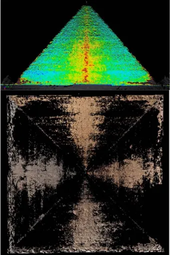
The Sphinx was scanned first from the top of the Cheops Pyramid to get data from the otherwise unvisible back of the monument (Fig. 6). The working distance was approx. 570 m, scan resolution was of 0.004 degrees resulting in a measurement spacing on the target of about 4 cm.
Fig. 6: Top: High resolution scan from the Sphinx from a distance of 570 m from the top of the Cheops Pyramid visualised as point cloud.
Bottom: Left: Scanner mobile in front of the Sphinx. Right: Triangulated point cloud of a single scan textured with the digital
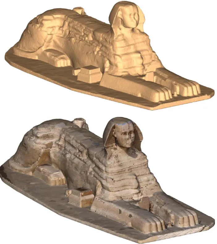
Fig. 7: Triangulated point cloud of the Sphinx combined from 7 scanner positions: 6 from the ground and one from the Cheops Pyramid, triangulated and textured in RiSCAN PRO 1.1.2β
To complete the threedimensional model of the Sphinx we recorded data from another 6 scanner positions set up around the Sphinx. Since the working time was limited by the authorities to 5 hours only we decided to use a scanner mobile for faster position change. Due to the limited time the model could not be closed completely. Therefore some areas hardly visible between the forelegs could not be scanned anymore.
The data from the six ground positions were linked together and registered using 20 reflectors set up in the pit where the monument is situated. This data is completed with the scan from the top of the Cheops pyramid. In a first processing step the data was triangulated using RiScan Pro on site. The produced mesh was textured with the images from the calibrated digital camera. For a first presentation the textured 3D model was animated one day after collecting the data (Fig. 7).
4. POST PROCESSING
The data collected can be post processed in numerous ways. According to the objectives of the project the first product to be derived from the collected point cloud is a detailed topographic model of the Cheops Pyramid and the surrounding Giza plateau. A first DTM was produced by reducing the amount of data points by resampling the point cloud into cells of a regular 0.5 x 0.5 m grid using RiSCAN PRO and exporting the data as formatted ASCII data for input to Arc GISTM. For the determination of the height value of each cell the lowest Z-values were selected. Using the functionality of 3D-Analyst the point cloud was triangulated into the internal TIN-format of Arc GISTM. For future processing we plan to extract breaklines from the point cloud using the photographic record to be added in the triangulation process to enhance the DTM. From the triangulated model contour maps or cross sections can be derived.
Thanks to the automatic registration of the image data within the scan data, the triangulated mesh can be textured with the high-resolution image-information without user interaction. For further post processing tasks export filters available in RiSCAN PRO guarantee a seamless workflow with other software products. The point cloud and digital images may be made available inside a CAD-Systems like AutoCAD and Microstation. Plugins available inside these CAD-Systems provide direct access to the RiSCAN PRO-project and thus to all information contained in the project such as the registration information gained during data acquisition.
To triangulate a model it is necessary to reduce the number of measurements from the total number of points to a lower level by means of re-sampling the data with a defined resolution For the first processing of the Cheops Pyramid the level of detail was set to 10 cm. The model covers an area of nearly 100 m x 100 m, and consists of about 1.5 million points. The triangulation of this point-cloud generates coarsely 3 million triangles. Triangulation of the point-cloud can be done by external programs and can be re-imported back to RiSCAN PRO. RiSCAN PRO offers also various ways to triangulate point-clouds. If only scan-data of a single scan-position need to be triangulated, this can be done by a simple 2D Delauny-triangulation of the neighboring points in the horizontal- and vertical-angle grid-raster of the scan. If scan data of numerous scan-positions should be triangulated, RiSCAN PRO offers the possibility to define the direction of 2D-Triangulation. The point-cloud can be triangulated from different sides and afterwards the overlapping meshes can be merged to a single mesh. The result is a “water-proof” 3D-Triangulation, which allows a straightforward calculation of volume and cross-sections. This procedure was as well applied for the production of a 3D model of the Sphinx.
For directly texturing the 3D model with the image data the calibration parameters of the camera such as focal length, image center, and radial distortion parameters have to be known, as can be achieved by the calibration procedure integrated into RiSCAN PRO (Ullrich et al. 2001, Ullrich & Schwarz & Kager 2003, Ullrich & Studnicka & Riegl 2005).
An alternative approach to full exploitation of the 3D information of the data set is the monoplot procedure, as used by PHIDIAS (Effkemann 2003), a software plug-in designed for MicroStation. This evaluation system provides all the necessary photogrammetric tools for the combined evaluation of laser data and image data, while being able to display the image and the scan data as point clouds simultaneously, one on top of the other. The basis of a combined evaluation of both records is the perspective representation of the scan data. The single frames can be co-oriented without consideration of the angles of
convergence between the pictures, because Phidias allows to import the original RiSCAN PRO-project. All calibration data and orientation data of the images are read directly from the RiSCAN PRO project. After the definition of a drawing surface out of the scan data as plane or triangulated mesh, the object can be digitized in the high resolution photograph (Fig. 8). The main geometrical information is extracted from the laser scan data, while for high-accuracy edge-detection and for digitizing high resolution details, which do not show up in the laser scandata, the image-information can be used.
Fig. 8 demonstrates how single stones of the Cheops Pyramid can be directly drawn in global 3D coordinates and get visible in the point
cloud, superimposed with the photograph by the Microstation-application PHIDIAS
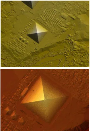
Fig. 9 shows anomalous areas, above: top view of the Cheops Pyramide with anomalies within each side, and beneath: horizontal projection of
5. FIRST RESULTS
The detailed DTM of the Cheops Pyramid revealed four anomalous areas in the centre of each side. These anomalies are areas starting at the top and obviously proceed down to the bottom where a deficiency in stones became visible. By defining idealised planes for the four sides of the Great Pyramid using the point clouds made it easy to visualise this deficiency as to be seen in Figure 9.
By animating the plane stepwise up and down its normal vector showed that a channel-like structure must have been existing in the centre of the four sides, that later was enlarged from top to bottom by corrosion. The meaning of this anomaly is still under research but might be seen in relation to the construction technique of the pyramid itself or has derived from the interface of a substruction for control of the limestone casing which was stripped off long ago and once covered the inner masonry of the Great Pyramid.
ACKNOWLEDGEMENTS
The mission was sponsored and equiped by RIEGL Laser
Measurement Systems (www.riegl.com) and VIAS-Vienna Institute for Archaeological Science, Vienna and was supported by the Supreme Council of Antiquities, the Austrian Embassy, Cairo and the Austrian Ministry of Education and Cultural Affairs. For assistance during field work we thank Johannes Riegl jr., Karolin Kastowsky and Stefan Frenzel. The authors want to express their special thanks for the support to Mrs. Hasbani, Cairo.
REFERENCES
Effkemann, C. 2003, Integrierte Auswertung photogrammetrischer Aufnahmen und Laserscandaten mit PHIDAS, Oldenburger 3D-Tage 2003.
Doneus, M. & Neubauer, W. & Studnicka, N., 2003. Digital Recording of Stratigraphic Excavations. In: Proceedings of the XIXth International Symposium CIPA 2003 "New Perspectives to Save Cultural Heritage". The CIPA Int. Archives for Documentation of Cultural Heritage, Vol. XIX, 2003, 451-456. Doneus, M. & Neubauer, W., 2004. Digital Recording of Stratigraphic Excavations. In: Ausserer, K.F. & Börner, W. & Goriany, M. & Karlhuber-Vöckl, L. (eds). Enter the Past. The E-way into the four Dimensions of Cultural Heritage. CAA 2003, Computer Applications and Quantitative Methods in Archaeology. BAR International Series 1227, Archaeopress, Oxford.
Doneus, M. & Neubauer, W., 2005. Laser scanners for 3D documentation of stratigraphic excavations. In: International Workshop on Recording, Modeling and Visualization of Cultural Heritage, Ascona, May 22-27, 2005 (in Press).
RIEGL, Laser Measurement Systems GmbH 2005, technical
data at www.riegl.com.
Ullrich, A. et al. 2001, Time-of-flight-based 3D imaging sensor with true-color channel for automated texturing, Optical 3-D Measurement Techniques V, Conference Proceedings p. 2-9, Vienna, October 1-4, 2001.
Ullrich, A. & Schwarz, R. & Kager, H. 2003, Using hybrid multi-station adjustment for an integrated camera laser-scanner system. In Optical 3-D Measurement Techniques VI, Volume 1, September 2003.
Ullrich, A. & Studnicka, N. & Riegl, J. 2005, Hybrid 3D laser sensor based on a high-performance long-range wide-field-of-view laser scanner and a calibrated high-resolution digital camera, SPIE Defense and Security Symposium, Proceedings 5412, Orlando, Florida.