University of Zurich
Zurich Open Repository and Archive
Winterthurerstr. 190 CH-8057 Zurich http://www.zora.uzh.ch
Year: 2010
Utilising urban context recognition and machine learning to
improve the generalisation of buildings
Steiniger, S; Taillandier, P; Weibel, R
Steiniger, S; Taillandier, P; Weibel, R (2010). Utilising urban context recognition and machine learning to improve the generalisation of buildings. International Journal of Geographical Information Science, 24(2):253 - 282. Postprint available at:
http://www.zora.uzh.ch
Posted at the Zurich Open Repository and Archive, University of Zurich. http://www.zora.uzh.ch
Originally published at:
International Journal of Geographical Information Science 2010, 24(2):253 - 282.
Steiniger, S; Taillandier, P; Weibel, R (2010). Utilising urban context recognition and machine learning to improve the generalisation of buildings. International Journal of Geographical Information Science, 24(2):253 - 282. Postprint available at:
http://www.zora.uzh.ch
Posted at the Zurich Open Repository and Archive, University of Zurich. http://www.zora.uzh.ch
Utilising urban context recognition and machine learning to
improve the generalisation of buildings
Abstract
The introduction of automated generalisation procedures in map production systems requires that generalisation systems are capable of processing large amounts of map data in acceptable time and that cartographic quality is similar to traditional map products. With respect to these requirements, we examine two complementary approaches that should improve generalisation systems currently in use by national topographic mapping agencies. Our focus is particularly on self-evaluating systems, taking as an example those systems that build on the multi-agent paradigm. The first approach aims to improve the cartographic quality by utilising cartographic expert knowledge relating to spatial context. More specifically, we introduce expert rules for the selection of generalisation operations based on a classification of buildings into five urban structure types, including inner city, urban, suburban, rural, and industrial and commercial areas. The second approach aims to utilise machine learning techniques to extract heuristics that allow us to reduce the search space and hence the time in which a good cartographical solution is reached. Both approaches are tested individually and in combination for the generalisation of buildings from map scale 1:5000 to the target map scale of 1:25 000. Our experiments show improvements in terms of efficiency and effectiveness. We provide evidence that both approaches complement each other and that a combination of expert and machine learnt rules give better results than the individual approaches. Both approaches are sufficiently general to be applicable to other forms of self-evaluating, constraint-based systems than multi-agent systems, and to other feature classes than buildings. Problems have been identified resulting from difficulties to formalise cartographic quality by means of constraints for the control of the generalisation process.
Accepted for publication in International Journal of Geographical Information Science, Manuscript version from 2 Feb. 2009
Utilising urban context recognition and machine learning
to improve the generalisation of buildings
S. STEINIGER†§*, PATRICK TAILLANDIER‡ and ROBERT WEIBEL§
† Department of Geography, University of Calgary, 2500 University Drive N.W., Calgary, Alberta, Canada T2N 1N4
§ Department of Geography, University of Zurich, Winterthurerstrasse 190, CH-8057 Zurich, Switzerland
‡ Laboratoire COGIT, Institute Géographique National, 2/4 avenue Pasteur, F-95165 Saint Mandé Cedex, France
*Corresponding author. Email: [email protected]
The introduction of automated generalisation procedures in map production systems requires that generalisation systems are capable of processing large amounts of map data in acceptable time and that cartographic quality is similar to traditional map products. With respect to these requirements we examine two complementary approaches that should improve generalisation systems currently in use by national topographic mapping agencies. Our focus is particularly on self-evaluating systems, taking as an example those systems that build on the multi-agent paradigm. The first approach aims to improve the cartographic quality by utilising cartographic expert knowledge relating to spatial context. More specifically we introduce expert rules for the selection of generalisation operations based on a classification of buildings into five urban structure types, including inner city, urban, suburban, rural, and industrial and commercial areas. The second approach aims to utilise machine learning techniques to extract heuristics that allow to reduce the search space and hence the time in which a good cartographical solution is reached. Both approaches are tested individually and in combination for the generalisation of buildings from map scale 1:5 000 to the target map scale of 1:25 000. Our experiments show improvements in terms of efficiency and effectiveness. We provide evidence that both approaches complement each other and that a combination of expert and machine learnt rules give better results than the individual approaches. Both approaches are sufficiently general to be applicable to other forms of self-evaluating, constraint-based systems than multi-agent systems, and to other feature classes than buildings. Problems have been identified resulting from difficulties to formalise cartographic quality by means of constraints for the control of the generalisation process.
Keywords: map generalisation; building generalisation; data enrichment; machine learning; expert knowledge; self-evaluating systems; multi-agent systems.
1 Introduction
The number of national mapping agencies (NMAs) that introduce automated map generalisation procedures into their map production workflows is steadily increasing (Stoter 2005). Conventional and automated map generalisation share the same basic objectives, which include fulfilling the intended map purpose and ensuring map legibility, taking into account user habits and principles of human visual perception. In order to achieve these objectives for automated map generalisation it is necessary to transfer the cartographic knowledge into a machine understandable form. Armstrong (1991) has identified three types of cartographic knowledge: a) geometric, b) procedural, and c) structural knowledge. The
geometric knowledge describes information on the size, shape and topology of map objects and can be obtained from measures applied on the objects’ geometry. Procedural knowledge
describes rules for the selection of appropriate generalisation algorithms in the presence of cartographic conflicts. For instance, if a building is too small to be clearly legible on the reduced scale map (a conflict), then the building may be enlarged (algorithm A) or eliminated (algorithm B). Finally, structural knowledge covers the cartographic knowledge needed to identify which objects and “structures” are important, e.g. in terms of their cultural, economical or geomorphological meaning. Thus, the structural knowledge influences the decision whether the small building of the above example must be preserved (enlarge building) or whether it is unimportant for the map reader (eliminate building).
An analysis of the pertinent literature as well as discussions with map production experts in NMAs that we have conducted revealed that existing automated generalisation systems need to be fine tuned, i.e. their knowledge refined, if they should be used (more) successfully in production lines. Hence, a specific focus of current map generalisation research is on the refinement of existing procedural knowledge that is currently applied in self-evaluating cartographic systems. In this article we particularly consider self-evaluating systems that are used for the production of (static) topographic maps by NMAs (Mackaness et al. 2007). As an example for self-evaluating systems we use systems that build on the Multi-Agent System (MAS) paradigm. In the context of such generalisation systems, we consider primarily two issues.
First, a high cartographic quality that is comparable to the quality of traditional maps can only be obtained with automated systems that treat every map object according to its context (SSC 2005). Hence, a topographic map production system should be able to account for spatial and semantic context information in the generalisation process. This requirement is exemplified by a recent call for tender by the Swiss NMA Swisstopo, who demanded the functionality to create and utilise generalisation zones, such as dense vs. scattered settlement zones, where every topographic feature (e.g. building or road) is treated differently depending on the zone (or context) that it is located in.
To make the generalisation process context-aware, the structural knowledge needs to be extracted and stored in a process that has been termed data enrichment (Ruas and Plazanet 1996, Neun et al. 2004). Afterwards the procedural knowledge can be refined with respect to the enriched data and structural knowledge. A context-dependent treatment can then be realised for instance by inclusion of expert rules into the system.
A second problem that has been reported for MAS in cartography is that the generalisation process can be computationally very expensive. This can be attributed on the one hand to the computational complexity of the generalisation task (see Haunert and Wolff 2008), but on the other hand also to the iterative local search approach used for the selection of a generalisation algorithm in a particular map situation (see § 2). Thus, acquiring and fine-tuning of procedural knowledge, i.e. rules for the selection of an appropriate generalisation algorithm, or an appropriate sequence of algorithms, should improve the efficiency of such systems.
The objective of this paper is to show two approaches with which the above-mentioned problems can be addressed, for the example of the generalisation of single buildings. In order to counter the first problem, context-dependent generalisation, we will try to use expert rules for the generalisation of single buildings to improve the quality of the resulting map. The expert rules have been defined based on the work by Boffet (2001) as well as results of experiments previously conducted at the Institut Géographique National, France (see also Lecordix et al. 2006). The second issue, computational performance of MAS, will be addressed by procedural rules that are acquired with machine learning techniques. The rules inferred from machine learning allow reducing the search space of the MAS reasoning mechanism (or ‘agent engine’) by introducing procedural heuristics.
Apart from developing and testing the expert rules approach and the machine learning approach individually we aim to test both approaches together. To the authors’ knowledge such an experiment is conducted for the first time, while reports on experiments with the individual approaches are sparse. We expect that both approaches are complementary, since we realise them in such a way that different components of the generalisation system are affected. Hence, our hypothesis is that the combination of both types of knowledge utilisation will help to improve the map generalisation process both in terms of efficiency (i.e. processing speed) and effectiveness (i.e. achieved quality). To test our hypothesis we will specifically examine knowledge for the generalisation of individual buildings for a topographic base map (scale 1:25 000). We start from existing rules that only take into account the internal conflicts of a single building in order to decide which generalisation algorithm to try applying on it next. We evaluate our hypothesis regarding efficiency by considering the time required to generalise a building. The evaluation regarding the improvement of effectiveness will be based on visual assessment of the generalised buildings.
The remainder of this paper is structured as follows. § 2 reviews agent-based systems currently used in map production, introduces the concept of constraints in MAS, and explains how MAS work. § 3 discusses limitations of generalisation systems and the approaches we propose to overcome these problems, including machine learning. § 4 presents the design of the experiment conducted in this study, § 5 the results, and § 6 the discussion of problems identified and possible improvements. We conclude in § 7 by recalling the main achievements and outlining perspectives for further research.
2 The current approach for building generalisation
Automated map generalisation systems based on the MAS paradigm are currently in use or being introduced in topographic map production of NMAs such as IGN France, Ordnance Survey (UK), or KMS (Denmark). These systems consist of several logical components. In general one can distinguish four components (Ruas and Plazanet 1996, Weibel and Dutton 1998): 1) constraints, 2) measures, 3) generalisation algorithms and 4) a mechanism that controls the generalisation process. The control mechanism is responsible for the decision making, determining how to generalise by evaluating the constraints (1) and triggering the generalisation algorithms (3). In the following sub-sections we will explain these four components with respect to building generalisation because we will later focus in the experimental part on the generalisation of buildings.
2.1 Constraints and algorithms for building generalisation
2.1.1 Constraints on building representation. A map should meet two basic requirements. First, the map should be designed to fulfil a specific purpose and second, the map must be legible. In order to specify these requirements in more detail and define how a good map
and Dutton 1998). The idea to introduce constraints for map generalisation has been proposed by Beard (1991), presumably inspired by the use of constraints in computer science. Here constraints are commonly used to restrict search problems. However, we note that the notion and the application of cartographic constraints and of constraints in search problems are slightly different (see e.g. Michalewicz and Fogel 2004). The constraint-based approach to automated map generalisation is now widely accepted as the standard approach for modelling the generalisation process (Harrie and Weibel 2007). Hence, we will also employ constraint-based modelling in this paper and describe the application in § 2.1.3 and § 2.2 below.
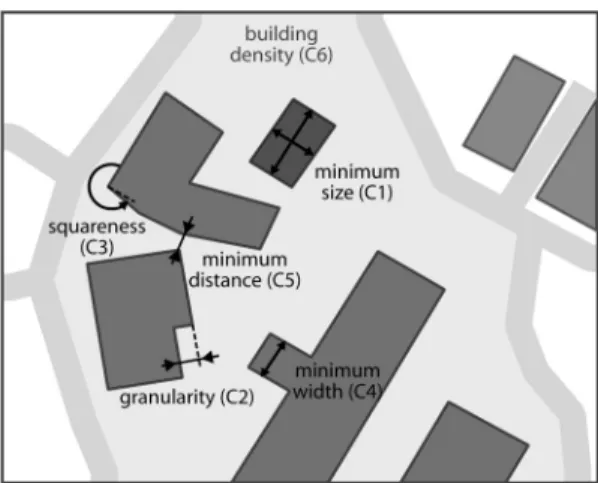
Several constraints have been found to be useful to describe the legibility of a map as described by Weibel and Dutton (1998) and by the AGENT Consortium (1998). With respect to buildings the legibility constraints identified focus exclusively on the geometrical aspects. In practical experiments during the “Nouvelle Carte de Base” project (Lecordix et al. 2006) at IGN France five constraints have been found to be useful (figure 1): (C1) minimum building size, (C2) building outline granularity, (C3) wall squareness, (C4) minimum inner-width, (C5) minimum distance between two buildings. Opposed to legibility constraints are preserving
constraints. Such constraints are used to prevent strong changes resulting from generalisation actions activated by violating a previously listed constraint. With respect to a single building one can identify at least four of these constraints in the literature. The first constraint is intended to prevent strong changes of the building shape and is called concavity constraint (C6, Bard 2004). The second constraint (C7) is called positional accuracy and should prevent that a building’s position is altered too much during building displacement. Such a displacement operation may be triggered due to a violation of the minimum distance constraint between buildings. The third constraint, denoted as conservation constraint, should prevent the elimination of important buildings (C8). This constraint demands a definition of importance on a structural or semantic level. For instance, hospital or school buildings are often considered as important type of building due to their unique function and their different geometrical characteristics compared to other buildings in a residential district. The fourth constraint is the building density preserving constraint (C9), which should ensure that the visually experienced density stays constant despite, for instance, building enlargement operations. Besides these four preserving constraints, also other constraints have been proposed for the generalisation of a group of buildings. An example is the alignment constraint (C10), which explicitly preserves building alignments (Gaffuri and Trevisan 2004).
In the remainder of this paper we will call the violation of a constraint a cartographic conflict.
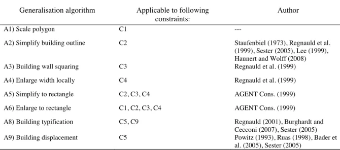
2.1.2 Actions for building generalisation. Several actions can be activated if one of the previously listed constraints is violated. An extensive listing of actions, so called generalisation operations, to meet the legibility constraints has been presented by McMaster and Shea (1992). For the generalisation of buildings, those actions focus either on the elimination or the geometrical transformation of buildings. We like to note here that in automated generalisation a particular cartographic operation, e.g. building displacement, can be realised with different algorithms that utilise different solution approaches. A list of generalisation algorithms that deal with the above mentioned constraints C1-C5 is given in table 1.
Table 1. Algorithms for building generalisation.
Generalisation algorithm Applicable to following
constraints:
Author
A1) Scale polygon C1 ---
A2) Simplify building outline C2 Staufenbiel (1973), Regnauld et al. (1999), Sester (2005), Lee (1999), Haunert and Wolff (2008) A3) Building wall squaring C3 Regnauld et al. (1999) A4) Enlarge width locally C4 Regnauld et al. (1999) A5) Simplify to rectangle C2, C3, C4 AGENT Cons. (1999) A6) Enlarge to rectangle C1, C2, C3, C4 AGENT Cons. (1999)
A8) Building typification C5, C9 Regnauld (2001), Burghardt and Cecconi (2007), Sester (2005) A9) Building displacement C5 Powitz (1993), Ruas (1998), Bader et
al. (2005), Sester (2005)
A violation of preserving constraints does not necessarily result in an activation of a specific operation or algorithm. In operational generalisation systems such constraints can additionally trigger a recovery of the initial state prior to generalisation (termed backtracking) or flag the result as invalid.
2.1.3 Evaluating constraints. One property of the constraint-based approach to modelling the generalisation process is that several cartographic constraints can be defined and evaluated first, and only then will it be decided what action is triggered to solve a given cartographic conflict. This procedure is especially of value if constraints are in conflict with each other such as C5 (minimum distance), and C7 (positional accuracy). To achieve a solution every constraint proposes none, one or several actions to solve a given problem. After all existing constraints have been evaluated, a ranking of all proposed actions is established and finally the most promising action is triggered.
But how can we know whether a constraint is fulfilled or not? Every constraint is associated with a measure (identified as the second component of a generalisation system above). This measure returns a quantitative value for a geometrical or topological property of one or more map objects. This value is then mapped into a qualitative statement, the so called
constraint satisfaction, by comparing it to a reference value, e.g. the minimum building size that corresponds to a particular target scale and map purpose. The qualitative statements can be expressed either as Boolean (true/false), integer scores (e.g. 1 to 5) or continuous floating-point scores (e.g. 1.0 to 5.0), using different mapping functions (Bard 2004). In our experiment we will use continuous scores in the range of 1.0 = constraint violated to 10.0 =
2.2 Controlling generalisation with an agent model
Of the four components of a state-of-the-art generalisation system listed at the beginning of this section, we have explained constraints, measures, and generalisation algorithms. What remains to be explained is the mechanism that controls the overall generalisation, and that allows to make associations between constraints, measures and generalisation algorithms (or operations), and to determine in which order the generalisation operations are carried out. This control mechanism is often termed inference engine. A variety of approaches for this purpose have been reported in the literature. A review of relevant techniques can be found in Harrie and Weibel (2007). The currently most promising techniques to solve this optimisation problem appear to be simulated annealing (Ware et al. 2003a), genetic algorithms (Ware et al. 2003b), and multi-agent systems (Ruas 1999, Barrault et al. 2001, Ruas and Duchêne 2007).
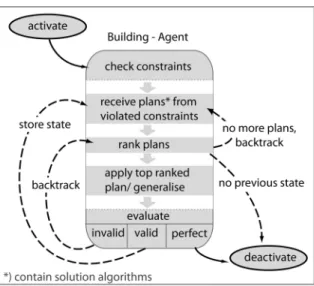
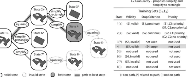
In our experiments, we will utilise the agent-based approach (based on the original work of Ruas 1999) and hence need to explain it in more detail regarding those elements that will be affected by our experiments. First, as we focus on building generalisation every building will be modelled as an agent. In agent-based modelling the term ‘plan’ is used to denote an action that can be executed by an agent to attain his ‘goals’. In automated map generalisation such a plan consists of a generalisation algorithm plus parameter settings, and goals correspond to cartographic constraints. A building agent gets assigned those legibility constraints that it must fulfil. The processing principle of the generalisation of such a building agent, the so-called agent lifecycle, is shown in figure 2. This process carries out a ‘trial-and-error’ approach that is known as local search method in computer science (Michalewicz and Fogel 2004) and which is essentially mimicking the work style of a cartographer. Every time a plan (i.e. a generalisation algorithm) is applied this is seen as one trial that results in a new agent
state. In the last step of a single lifecycle the current state is evaluated and classified as ‘valid’, ‘invalid’ or ‘perfect’ state based on a so-called happiness value. For each state, the happiness is calculated as a weighted average of the constraint satisfaction values over all constraints. A state is usually considered as valid if the happiness or the satisfaction of the constraint that proposed the executed plan has improved compared to a previous state. For all other cases the state is considered as invalid. A state is classified as perfect if all constraints are satisfied (no violation). In the latter case the generalisation of the building is terminated while for the other two cases the state is stored and the generalisation process continues with a new trial. For a valid state the process continues from the current state, whereas for an invalid state the system will return to a previous valid state and continue from there. Thus, invalid
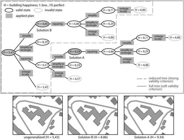
states are never considered as starting points for further actions, which may lead to the omission of good solutions that emanate from those. Finally, after all plans have been tried, the system will select the one state as generalisation solution that best fulfils all constraints (i.e. has the highest happiness value) of all stored states. The described trial-and-error generalisation process is depicted as a process tree for one building in figure 3.
To conclude this section, we aim to discuss the parameters used for controlling the generalisation process in the agent model. The first parameter is called constraint importance
and represents a weight that is assigned to each constraint type in order to calculate the overall happiness value of an agent as a weighted average. The second parameter, constraintpriority, is used to determine in which order constraint violations should be solved. Defining an appropriate order is useful since the preceding solution of one conflict may involve an easier solution for a following conflict. For instance, if a minimum size conflict (C1) is solved first by building enlargement, then a previously detected minimum width conflict (C4) could have been solved at the same time. Finally, giving individual weights to a plan is necessary to define which plan should be executed before another plan that has been proposed by the same constraint. As a rule of thumb preference should be given to plans that results in less (geometrical) changes. All three parameters are usually pre-defined by an expert but may also be set dynamically at runtime (Ruas 1999). For a more detailed introduction of multi-agent models in cartographic generalisation we refer to the review by Ruas and Duchêne (2007).
Figure 3. Search tree of possible generalisation solutions for one building. The best solution is A, corresponding to a high happiness value close to 10.0. It is normally selected as the final solution. In § 3.1 we explain under
3 Ways to improve building generalisation
In the previous section we have introduced an approach for the generalisation of buildings that is based on constraint modelling and the use of a multi-agent system to control the generalisation process. We further listed the constraints that should ensure map legibility, (preserving) constraints that should avoid excessive changes, and algorithms for resolving cartographic conflicts. In this section we aim to introduce two approaches for the improvement of knowledge applied in the agent-based process control. After discussing deficiencies and possible improvements (§ 3.1), we will give a short overview of previous work (§ 3.2). Subsequently we describe one approach for the refinement of procedural knowledge (§ 3.3) and one for the extraction of procedural knowledge by machine learning (§ 3.4).
3.1 Deficiencies of the current approach and possible improvements
As outlined in the introduction we aim to improve the MAS-based generalisation approach in two respects. On the one hand we focus on making the system more computationally efficient while on the other hand we want to improve the effectiveness (i.e. the cartographic quality). Therefore it is necessary to analyse the current approach to generalisation process control.
The disadvantage of the local search approach is that it can be very extensive due to the combinatorial nature of our search problem. An analysis of the tree in figure 3 reveals that the tree contains redundancies (the same sub-branch exists twice) and a number of the branches end with unsatisfactory and invalid solutions. Thus, in both cases processing efforts could be reduced, and computational efficiency increased, if either 1) dynamic validity and termination criteria are applied, or 2) the list of available plans and the selection of plans are better controlled. A dynamic, context-dependent setting is necessary since a static validity criterion, used for all buildings, may result in cases in which the best solution is missed (in figure 3 solution B instead of A). We will provide solutions to both of the above cases. Dynamic validity and termination criteria will be set by rules that are derived with machine learning techniques. An improved control of the plan list and plan selection will be achieved with rules obtained inductively with machine learning techniques but also with deductive expert rules. In both cases we will allow only plans to be proposed that are appropriate for the specific cartographic context of a particular building.
Improving the system in terms of cartographic effectiveness is also related to the proposal of plans adapted to the spatial and semantic context of map objects. But here we aim to obtain a cartographically more convincing solution that should theoretically correspond to a higher number of satisfied constraints, hence higher values of happiness. Thereby a smaller set of trials will probably be a side effect of the adaptation to the context. An improvement in effectiveness is possible by introduction of expert rules. Note that the use of expert rules can result in improvements that we are not able to evaluate quantitatively, since visually obvious improvements are not necessarily recognized by the quantitative measures used by our set of constraints. A gain in effectiveness is also possible with machine learnt rules (Taillandier 2007). However, this holds only if the rules are learnt from a comprehensive solution tree (i.e. using a weak validity criterion), while the reference generalisation system applies a strong validity criterion.
3.2 Related work to improve the performance of generalisation systems
The use of expert rules in cartographic systems has experienced a mixed history. In the heyday of ‘expert system’ technology in the late 1980s a series of studies was reported using expert rules in map generalisation and related areas (Mackaness et al. 1986; Mackaness and Fisher 1987; Nickerson 1988; Doerschler and Freeman 1992; Schylberg 1993). These early
activities were followed by a relatively long period of silence, which was due to the scarcity of formalised cartographic knowledge: If no expert rules exist, no expert system can be built. Hence, research turned to knowledge acquisition during the subsequent years, including the utilisation of machine learning techniques for the extraction of generalisation processing rules. After initial experiments by Weibel et al. (1995), Plazanet et al. (1998) developed a supervised learning approach for the selection of appropriate line generalisation algorithms, primarily for roads. This work was later extended by Mustière (2005). Mustière et al. (2000) and Ruas et al. (2006) evaluated learning-based methods for the extraction of rules for the generalisation of buildings. Of the above, only Ruas et al. (2006) focused on learning rules from mining the logs of a self-evaluating generalisation system to improve its efficiency. The other studies extracted rules from logging human expert interactions with interactive systems to improve the quality of automated generalisation results. Our research continues the work by Ruas et al. (2006) but we use a different rule learning approach and directly integrate (i.e. test) the obtained rules within the multi-agent system that was used.
Experiments with expert rules to guide the selection of generalisation algorithms in self-evaluating systems have rarely been reported so far, owing to the relatively recent introduction of such systems. Gaffuri and Trévisan (2004) used the classification of urban areas by Boffet (2000, 2001) into different zones (e.g. urban blocks, dense residential, scattered residential, industrial etc.) to enable a contextual treatment of the blocks. Similar work was reported by Revell et al. (2006) to differently generalise buildings in urban and rural environments. Our approach differs from the above in that we differentiate between more types of situations. Also, we use a classification that is assigned as an attribute to each individual building, rather than to entire classes of buildings. That provides the capability of generalising a supermarket in a housing area differently than the surrounding residential houses.
3.3 Context analysis and building classification
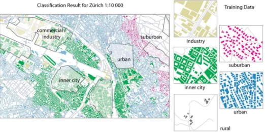
The objective for the use of expert rules in the generalisation process is to ensure that a particular map object receives a context-dependent treatment. Hence the expert, i.e. a cartographer, needs to identify first what objects need special treatment. Then, methods have to be defined that select those objects. Finally, the (expert) rules are set up, defining the generalisation procedure for these objects. In our case study the expert generalisation rules will utilise higher order semantic concepts related to the urban fabric. Such concepts are implicitly (or latently) contained in the map data but are not explicitly coded and hence need to be extracted and made explicit with pattern recognition techniques. A condition for the usability of such higher order semantic concepts is that they can be related to existing cartographic map generalisation rules, while at the same time the concepts must be intuitive to understand for the person using the map. Based on an analysis of the generalisation literature (e.g. SSC 2005), the study of topographic maps, and the study of maps for urban planning and education, Steiniger et al. (2008) identified five urban structure classes that are often used: (1) inner city buildings, (2) industrial and commercial buildings, (3) urban buildings, (4) suburban buildings and (5) rural buildings. To assign buildings to one of these classes Steiniger et al. (2008) propose a supervised classification approach that establishes a mapping between geometrical properties of buildings and the above urban structure classes. We applied this classification approach implemented as a web-generalisation service by Neun et al. (2008). The result of the classification process for a dataset of Zurich (Switzerland) is shown in figure 4. As features for the classification the following geometric properties of the building geometry have been used: I) area; II) number of corners; III) shape index; IV) squareness; V) elongation; and VI) the number of courtyards. Additionally, the following
200 m buffer to the buffer area, calculated for every building. The classifier used was a support vector machine (SVM) with a radial basis function (RBF) kernel (for details, see Steiniger et al. 2008). We reached an overall classification accuracy of 82 percent (kappa statistics: 0.73), meaning that there is a chance of 18 misclassified buildings out of 100 buildings.
Once classified, every building can be related to its (urban) context, represented by the urban structure type that it has been classified into. Based on this information, we are able to introduce expert rules in the generalisation system that trigger specific generalisation algorithms and algorithm sequences for each individual building (see below in § 4.1.2). The set of expert rules is introduced and evaluated during the collection of plans, which happens in the agent lifecycle step 2 of figure 2. Here, the expert rules control the compilation of the list of plans, where plans are proposed by a violated constraint to the inference engine. For misclassified buildings, however, the list of generalisation algorithms proposed by the expert rules can be inappropriate. For instance, the set of algorithms for a suburban building that has been misclassified as an inner city building may not be suitable.
3.4 Learning rules with machine learning techniques
3.4.1 What we aim to learn. To improve the efficiency of the generalisation system, we would like to learn rules of the following structure: If (building_size < 200 m2) And
(building_type = inner_city) Then (privilege building_elimination_plan). The advantage of such rules is that they are easy to interpret and subsequently also useful to evaluate existing knowledge of the generalisation system. In accordance with previous positive experiences reported in Taillandier (2007) we decided to focus on three different rule types. These three types should facilitate the following actions:
1. Choosing a branch (of the search tree) – The first rule type is called priority rule and helps to identify the constraint which should be solved next to obtain the best solution (in terms of a high happiness value) with as few generalisation trials as possible. Thus, this type of rules will try to minimise the number of tested solutions and subsequently the size of the search tree in figure (3).
2. Avoiding a branch – The second rule type is called validity rule and is used to identify situations in which it is likely that no acceptable (i.e. an invalid) solution is obtained if one proceeds with the current generalisation result. Such rules help to avoid unnecessary generalisation tries.
Figure 4. Classification results for the Zurich building data. The lighter areas mark the training data. (Data courtesy of the City of Zurich, Geomatik + Vermessung, 16.10.2007).
3. Terminate process – Finally the third type of rules to be learnt are termination rules. They identify situations in which the generalisation process should be terminated prematurely since obtaining better solutions in terms of a higher happiness value is unlikely. Thus, the number of generalisation trials is limited by these rules.
3.4.2 General learning method. In the artificial intelligence and data mining community several rule learning approaches have been developed (Hand et al. 2001, Witten and Frank 2005). For our purposes we will use a supervised rule learning approach, which means that we will have to provide training samples to the learning algorithm. The approach follows the general three phase learning scheme:
1. Exploration step - This step consists in logging the actions of the generalisation process for a large number of geographical objects. During this phase, the process uses the procedural knowledge initially contained in the generalisation system. The logs record the whole information related to successes and failures of the various actions invoked by the system, and hence of the procedural knowledge it contains.
2. Analysis step - This step is comprised of analysing the logs obtained during the previous phase and in deducing new knowledge from it. Thus, the training samples are selected from the database generated in the analysis step and afterwards the rules are learnt from these samples.
3. Exploitation step – The third step involves testing the obtained rules with the generalisation system on a different dataset. Hence, we can evaluate whether the learnt rules lead to an improvement of the generalisation process.
We will describe the two parts that are essential for our experiments, that is, the creation of the training samples and the generation of rules, in the next sub-sections. The results of the third step are presented in § 5.
3.4.3 Training samples selection. For the rule learning it is necessary to define from which kind of data the rules should be learnt. In the case of supervised learning every sample of the training data must consist of a description vector that is used to define the condition, and a label that corresponds to the action. For our purposes we will use the constraint satisfaction of every state and the building type as description vector. The labels will be defined according to
Figure 5. Examples of training sets built from a generalisation search tree for one building. One training set i consists of the descriptor (state Si, label Li).
related to the best (successful) path to the final solution. This definition allows obtaining a correct state characterisation and at the same time is not too complex for the learning procedure. In figure 5 we give an example that shows which states of the generalisation process of one building are used for the training. The state Si in figure 5 is a vector that contains the satisfaction values for squareness and concavity but also the type of the building class (rural, suburban, etc.). Obviously, however, the final set of training data used as input for the rule learning algorithm will consist of samples obtained from several dozens of buildings, and not only from a single one.
3.4.4 Learning method used. The technique that we will use for learning the rules is exception-based learning (Witten and Frank 2005). In particular we use a learning approach that consists of two components: the algorithm that generates/extracts the (exception) rules called IREP (Incremental Reduced Error Pruning; Fürnkranz and Widmer 1994) and a data structure for the management and application of the rules called RDR or RIDOR (Ripple-Down Rules; Compton et al. 1991).
One common approach to learn rules is to generate a decision tree first, then to transform the tree into a set of rules, and finally simplify the rule set (Frank and Witten 1998). This approach is for instance used in the C4.5rules algorithm (Quinlan 1993). The other approach, used by IREP, applies a ‘separate-and-conquer’ strategy (for the difference to ‘divide-and-conquer’, see Fürnkranz and Widmer 1994). Here, the most powerful rule is determined, i.e. the rule that covers most training examples, and afterwards all examples that are covered by this rule are deleted. This process is repeated if there are no positive examples left, or until the last rule found produces an unacceptably large error rate (Cohen 1995).
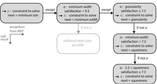
Ripple-Down Rules is a data acquisition methodology that should ensure rule sets having minimal inter-rule interactions and simple maintenance (Gaines and Compton 1995). Developed for the management of rules that are provided by experts the ripple down rule methodology can be used also to manage learned rule sets. In a ripple-down rule knowledge base the rules form a binary decision tree. A default rule is generated first and then the first rule delivered by IREP is used as exception. Subsequently follow-up rules from IREP are added as exceptions to the predecessor rule and a classification tree emerges. Figure 6 provides a real-world example for a Single Classification Ripple Down Rule (SCRDR)
Figure 6. Examples of a Single Classification Ripple-Down Rule (SCRDR) knowledge base to decide which generalisation constraint to solve next based on the evaluation of the constraint satisfaction. The condition for
knowledge base that has been learnt to determine which generalisation constraint to solve next.
Choosing a rule learning approach for a particular problem is difficult. Using RIDOR to maintain the knowledge base of rules and not only the rule learner, enables to learn a structured set of rules, which is easier to interpret than a mere list of rules. IREP may have deficiencies compared with its successor RIPPER or C4.5rules but is comparably efficient to the latter (Cohen 1995). In contrast to ID3, another well-known tree generating algorithm ( Witten and Frank 2005), IREP handles also continuous data, not only nominal data. Furthermore, the combination of IREP and RIDOR is implemented ready-to-use in the OpenSource learning framework WEKA (Witten and Frank 2005).
4 Experiment
4.1 Experimental setup
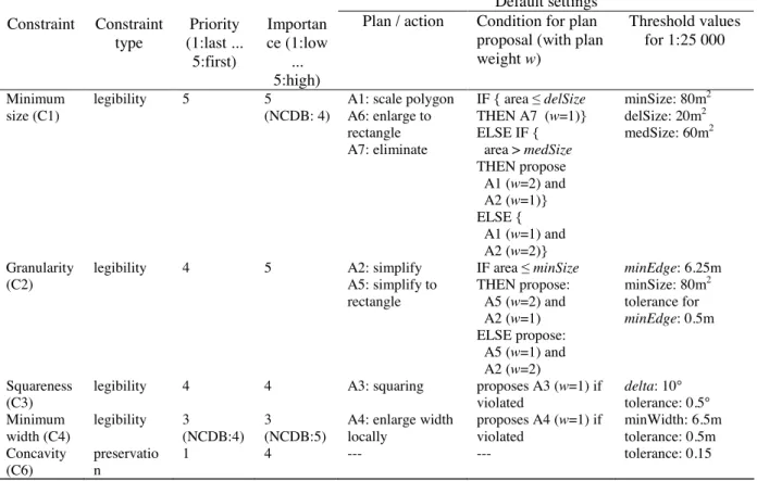
4.1.1 Target map scale and derived constraint settings. For the experimental part we decided to focus on the generalisation of buildings for the base map scale of 1:25 000, starting off from data at a nominal scale of 1:5 000 to 1:15 000 (cf. § 4.1.3). Given that we exclusively want to deal with the generalisation of single buildings, focusing on such a large scale has the advantage that only few buildings need to be eliminated (Müller 1990) and only few displacement operations due to overlaps between buildings and between buildings and roads are necessary. Thus, complex operations such as building typification for dense built-up areas are not considered and it is easier to evaluate the effects of the expert and learnt rules. Hence, the set of constraints that we applied involves only the following constraints for individual buildings: C1 – minimum size; C2 – granularity; C3 – squareness; C4 – minimum width; and C6 – concavity. The minimum distance constraint is not applied for two reasons: On the one hand displacement operations can be executed after the previously mentioned constraints are satisfied. On the other hand, if the generalisation of one building is influenced by the generalisation of its neighbour buildings it is harder to identify emerging knock-on conflicts due to geometry transformations. In table 2 the constraints, their parameter settings and the plans (i.e. generalisation algorithms) are listed that are proposed if a constraint is violated. We adopted the parameters and plans as developed by experts during the two projects AGENT (Barrault et al. 2001) and Nouvelle Carte de Base (NCDB, Lecordix et al. 2006), with small modifications. The parameters (thresholds) listed in table 2 have different meanings. For instance minSize, delSize and medSize are used to ensure a minimum building size (constraint C1). Based on a comparison with the thresholds delSize and medSize it is decided whether a building will be eliminated or enlarged to meet the minimum size constraint (minSize). Tolerance values, such as the one for minEdge, should avoid actions that result in small, unnecessary changes when the current value is close to the goal value. For instance, if the length of a building wall is 6.0 m, then the building is not generalised with a simplification algorithm, due to the length tolerance of 0.5 m (threshold minEdge set to 6.25 m). Since we assume that the settings and proposed plans of the constraints C1 to C4 are intuitive to be understood we will only explain the settings for the defensive constraint C6 (concavity).
Constraint C6 should ensure that geometric transformations applied to one building do not change the building shape in an unacceptable way. Therefore the ratio of the area of the original building to the area of its convex hull is computed, and the ratio values before and after generalisation are compared (Bard 2004). In table 2 it can be seen that the constraint C7 has a low priority, a high importance and does not propose any plans. The value for the priority parameter is low since priority proposes no plans. If the change of the building outline is too strong it is desired that the solution be rejected, and either another plan applied or the
lower happiness value for the building than before. The lower happiness value will then prevent that this state is selected as the best solution, since other states (even the initial state) should receive higher happiness values.
Table 2. Constraints used in the experiment for the scale change to 1:25 000 used for the reference building
generalisation. Settings are similar to the Nouvelle Carte de Base project (NCDB, Lecordix et al. 2006).
Default settings Constraint Constraint type Priority (1:last ... 5:first) Importan ce (1:low ... 5:high)
Plan / action Condition for plan
proposal (with plan
weight w) Threshold values for 1:25 000 Minimum size (C1) legibility 5 5 (NCDB: 4)
A1: scale polygon A6: enlarge to rectangle A7: eliminate IF { area delSize THEN A7 (w=1)} ELSE IF { area > medSize THEN propose A1 (w=2) and A2 (w=1)} ELSE { A1 (w=1) and A2 (w=2)} minSize: 80m2 delSize: 20m2 medSize: 60m2 Granularity (C2)
legibility 4 5 A2: simplify A5: simplify to rectangle IF area minSize THEN propose: A5 (w=2) and A2 (w=1) ELSE propose: A5 (w=1) and A2 (w=2) minEdge: 6.25m minSize: 80m2 tolerance for minEdge: 0.5m Squareness (C3)
legibility 4 4 A3: squaring proposes A3 (w=1) if violated delta: 10° tolerance: 0.5° Minimum width (C4) legibility 3 (NCDB:4) 3 (NCDB:5)
A4: enlarge width locally proposes A4 (w=1) if violated minWidth: 6.5m tolerance: 0.5m Concavity (C6) preservatio n 1 4 --- --- tolerance: 0.15
4.1.2 Expert rules introduced. The settings of table 2 are used to obtain the reference generalisation results for the comparison with the results gained with expert rules and learnt rules. The learnt rules which we introduce to the generalisation system are presented in the results section (§ 5) since they are derived from an actual generalisation run with the settings given in table 2. In contrast, the modifications of the settings and plans of table 2 evolving from expert rules are conceptual and the outcome of knowledge elicitation from experts. The context-dependent expert rules, presented in table 3, have been elaborated by the authors when comparing the results of an MAS-based generalisation system with NMA map specifications from IGN France and Swisstopo. With these rules we aim to realise the following cartographic considerations: Industrial and commercial buildings should not be squared since the building sizes tend to be large and are adapted to the previously existing infrastructure. This affects also the possibility to simplify buildings to a rectangle, since a representation as a block is on the one hand inadequate with respect to their often complex shape and on the other hand may result in overlaps with other infrastructure objects (roads and buildings). Similar considerations exist with respect to inner city blocks. Usually the individual buildings forming a block adapt to the nature of the topography and the existing infrastructure. Particularly in (European) old towns where the urban fabric has been shaped over centuries straight shapes of building blocks are rather unusual, as can be seen in the Zurich dataset presented below (figure 7, old town on the lower left). An additional rule applied to the inner city buildings is to eliminate unimportant small buildings to strictly retain free space for necessary building enlargement and displacement operations. Assuming that in suburban areas residential districts dominate, consisting of individual and rather small
buildings, we propose to enforce the plan which simplifies small houses to rectangles instead of trying out time consuming building wall by wall simplification that is followed by an enlargement operation. This assumption is also applied to buildings in the rural context. A second objective for rural buildings is to preserve even small buildings as far as possible, since they may be an important point for the map reader’s orientation, e.g. if the map is used for hiking.
From the above considerations and table 3 it can be obtained that no specific rules are introduced for urban buildings. Thus, they are handled with the modified reference settings of the NCDB project. To all other urban context classes we have been able to assign specific rules. Hence, every urban context class except ‘urban buildings’ has its own, cartographically justified set of rules.
Table 3. Expert rules accounting for the specificities of five urban context classes, applied to the settings of table 2. The proposed changes are explained in § 4.1.2.
Contextual application rules
Constraint Industry and
commercial Inner city Urban Suburban Rural
Minimum size (C1) --- 1. Set delSize to minSize 2. Don’t propose Enlarge to rectangle (A6) --- Set weight of Enlarge to rectangle (A6) higher than for Scale polygon (A1)
1. Don’t propose Eliminate (A7) 2. Set weight of Enlarge to rectangle (A6) higher than for Scale polygon (A1) Granularity (C2) Don’t propose Simplify to rectangle (A5) Don’t propose Simplify to rectangle (A5)
--- --- Set weight of Simplify to rectangle (A5) higher than
for Simplify (A2) Squareness (C3) Don’t propose Squaring (A3) Don’t propose Squaring (A3) --- --- ---
4.1.3 Test data, generalisation system and learning framework. For the experimental part we used two datasets. The first dataset from Switzerland, AV-Light data provided by the City of Zurich, contains building data with a resolution corresponding to a 1:5 000 map scale. The buildings have been classified according to the approach described in Steiniger et al. (2008); see also § 3.3 and figure 4. In a step preceding the generalisation buildings touching each other were merged into one building. Such a merge could be done as well with the agent approach, but then we would need to introduce so-called meso agents that control several single building agents together (see Ruas and Duchêne 2007). This would add an additional level of complexity and make the experimental setup and evaluation more difficult than necessary.
The second dataset contains buildings from the region of Orthez in France and has been extracted from the IGN BD-Topo® database. The French data have a resolution of about 1 m, corresponding to a map scale of roughly 1:15 000. The building data are pre-classified with a classification approach of Boffet (2001), which is better adapted to the French data than our generic approach. To utilise this existing context classification we applied a mapping between the – partially similar – concepts, given in table 4. For the French data a merge operation for touching buildings has been applied as well if the buildings were of similar function type.
For the generalisation of the buildings we used the commercial map generalisation system
Radius ClarityTM by 1Spatial (2007). This software has been developed from the prototype of the AGENT project (Barrault et al. 2001) and the inference machine can be adapted to use different search heuristics (i.e. so-called pruning strategies). We applied generalisation algorithms delivered with Radius ClarityTM to explore potential algorithmic deficiencies of the commercial system for further experiments. As mentioned previously the system does not explore the full tree of possible generalisations for a building in order to avoid redundant
one of the constraint satisfaction values for the current solution (state) has improved compared to every previously generated solution.
Table 4. Mapping of the urban context classes given for French BD-Topo® data to the classes used for the expert rules of table 3.
French urban context classes after Boffet (2001)
Mappings to urban context classes
used in Steiniger et al. (2008)
Notes
Centre Ville Inner City ---
Divers Urban Sometimes Inner City or Industrial and Commercial may also be appropriate
Fermé Suburban Sometimes rather Rural
Lotissement Suburban ---
Peri urbain Urban Sometimes rather Suburban
Unitaire Rural ---
Activité Industrial and Commercial ---
4.2 Evaluation Strategy
4.2.1 Effectiveness – cartographic quality. An evaluation of the improvement in cartographic quality due to the introduction of urban context rules (i.e. the expert rules) is accomplished by visual inspection, not in a quantitative manner, by use of the overall happiness. This decision was necessary since our first experiments showed that we are not yet able to sufficiently formalise cartographic quality in quantitative terms (see discussion section §6.2). An improvement in cartographic quality for the rules inferred by machine learning is not possible, since these rules are derived from analysing the values of constraint satisfaction for the reference generalisation. In other words, the learning system does not receive information how a ‘perfect’ generalisation result should look like but only information about the best result achieved with the reference setup. Hence, in terms of cartographic quality the machine learnt rules will simply reproduce the result of the reference generalisation, provided the rule learner works perfectly; but it can be expected that this result will be achieved faster (§ 4.2.2).
4.2.2 Efficiency – processing speed. To evaluate whether the efficiency increased when rules are applied we generated statistics for the generalisation process with respect to a) the number of generalisation trials for one building, b) the necessary time to generalise a building, and c) the average happiness. Differentiating between the number of solutions and the processing time is useful because different generalisation algorithms require different amounts of time for computation. Hence, the same number of solutions does not necessarily result in the same execution time for the overall generalisation process. For instance, the simplify algorithm (A2) is a comparatively time consuming algorithm since it generalises every building wall separately. If the algorithm is avoided the efficiency with respect to processing time will improve whereas the number of tried solutions can still remain the same.
5 Results
5.1 Rules learnt
In the machine learning part of the experiment we concentrated on obtaining rules from the analysis of the course of the happiness function obtained in previous runs of the MAS. This happiness function is calculated as a weighted average of the constraint satisfaction for every state of a building agent. For the learning process we used 288 buildings as training data from
the Zurich sample dataset, which contains 724 buildings (figure 7). As described in § 3.4.1 we learnt three types of rules: 1) priority rules, 2) validity rules, and 3) termination rules. All rules learnt for the Zurich data are listed in table 5. It can be seen that two of the termination rules (rules 7 and 8) not only account for the evaluation of a constraint satisfaction but also for urban structure types. Thus, a first hint is provided that the introduction of the urban structure concepts helped to better characterise the buildings, which in effect may increase generalisation efficiency.
Table 5. Rules learnt from a test generalisation of buildings from the Zurich dataset (figure 7, middle). A satisfaction value of 10 corresponds to a fully satisfied constraint.
Rules for automated setting of constraint priority
Rule 1 IF (minimum size satisfaction 9.5*) THEN constraint to solve next = minimum size
Rule 2 IF (minimum size satisfaction > 9.5) AND (granularity satisfaction 7.5) THEN constraint to solve next = granularity
Rule 3 IF (minimum size satisfaction > 9.5) AND (granularity satisfaction > 7.5) AND (minimum width
satisfaction > 7.5) THEN constraint to solve next = squareness
Rule 4 IF (minimum size satisfaction > 9.5) AND (granularity satisfaction > 7.5) AND (minimum width
satisfaction 7.5) AND (8.5 squareness satisfaction > 5.5) THEN constraint to solve next =
squareness
Rule 5 IF (minimum size satisfaction > 9.5) AND (granularity satisfaction > 7.5) AND (minimum width
satisfaction 7.5) AND {(squareness satisfaction 5.5) OR (squareness satisfaction > 8.5)} THEN constraint to solve next = minimum width
Rules for checking the validity of a transformation
Rule 6 IF (squareness satisfaction = 10) AND (concavity satisfaction 5) THEN invalid state
Rules for terminating the generalisation of a building
Rule 7 IF (type = industry & commercial) AND (minimum size satisfaction = 10) AND (granularity satisfaction = 10) THEN stop
Rule 8 IF (type = inner city) AND (minimum size satisfaction = 10) AND (granularity satisfaction = 10) AND (minimum width satisfaction = 10) THEN stop
Rule 9 IF (squareness satisfaction = 10) AND (minimum size satisfaction = 10) AND (granularity satisfaction = 10) AND (minimum width = 10) THEN stop
5.2 Results for expert rules
Figure 7 shows the generalisation results for a part of the Zurich data. As previously mentioned we did not apply displacement operations to make the identification of problems with individual buildings easier. Thus, overlaps between buildings and roads are possible. A comparison of the result for the reference settings of table 2 (figure 7, middle) with the control settings that are derived from expert rules and dependent on urban context (figure 7, bottom) shows that especially for inner city and industrial & commercial buildings the cartographic quality is preserved. More specifically with the reference settings a number of buildings are simplified to a rectangle resulting in overlaps with streets and nearby buildings. With the context rules, such cases are avoided. A disadvantage of the introduced rules is that in some cases too much detail of the buildings is retained (see dashed circle in figure 7). Deficiencies of the building simplification algorithm that is triggered by the granularity constraint can be recognised as well. Often courtyards are not preserved although they would be large enough for visualisation (see black rectangle in figure 7).
To evaluate improvements in the efficiency we prepared the diagrams given in Figure 8. One can obtain from the time diagram that we achieved a processing time reduction by approximately 15% for the Zurich data. Such a significant reduction does not appear for the Orthez dataset, however (approx. 1 %). We see a reason for these different results for the two datasets in the proportion of contextually generalised buildings compared to the reference generalisation. For instance, the fraction of inner city and industrial buildings is 21 % for Zurich and only 6 % for Orthez.
5.3 Results for learnt rules
For the Zurich dataset we obtain a similar reduction in processing time as for the expert rules of about 14% (see Figure 8). In contrast to the experiment with expert rules, however, the learnt rules achieve a considerable time reduction of 27% for the Orthez dataset. This
Figure 7. Generalisation results for 1:25 000 map scale for a sample of the Zurich building data. Note that the displacement operation has been excluded from the experiment. (Data courtesy of the City of Zurich, Geomatik
improvement in terms of efficiency has been determined as well by Taillandier (2007) with the rule learner C4.5. A negative effect with respect to cartographic quality appears for the application of the machine learnt rules, which can be seen in figure 9. In some cases the learnt rules propose the simplification of buildings to rectangles although the loss of detail is not acceptable from a cartographic point of view. In figure 8 one can see that the average happiness value slightly decreased when the learnt rules are applied. This may indicate that the rules learnt are not necessarily leading to best solution obtained with the reference system, i.e. the learnt rules are not perfect.
5.4 Results for a combined application of expert and learnt rules
With respect to improvements in efficiency we obtained very satisfying results: For the Zurich data we measured a reduction in processing time of about 45%, and for the Orthez dataset a reduction of approximately 30% (figure 8). The positive effects of an improvement in visual quality resulting from the expert rules are retained. However, the degradations for a few buildings that can be recognised in figure 9 also stem from the learnt rules. Fortunately in most of these cases this happened for rural buildings only. Thus, such strong simplifications could be avoided by introducing a corresponding expert rule specifically for rural buildings. An additional experiment with such an expert rule that preferred a building wall-by-wall simplification over a transformation to a rectangle prevented the oversimplification.
6 Discussion
6.1 Summary of improvements
This study departed from the hypothesis that the effectiveness and the efficiency of multi-agent systems for cartographic generalisation can be improved by a combination of expert rules, obtained from knowledge elicitation from expert cartographers, and rules that were
Figure 8. Statistics for the generalisation of the data for Zurich, Switzerland and Orthez, France. The absolute generalisation times for both datasets are not comparable due to different memory needs and logging settings.
As the above results demonstrate we generally obtained the improvements that we were striving for with respect to the chosen improvement method, that is, rule type. Table 6 summarises the improvements and also lists the main problems identified. The particular strength of the expert rules is the improvement of the cartographic quality, but also a reduction in processing time could be achieved as a secondary effect, at least for the Zurich data. The effect of the application of machine learnt rules is that the efficiency could be improved by a reduction in processing time.
Table 6. Summary of chosen approaches and experimental results.
Method Description and Results
Expert rules Description Expert rules influence the proposed plans and their ranking (plan weight) based on evaluation of additional information.
Result: Effectiveness Better visual appearance of generalised objects (buildings), i.e. preservation of object details and avoidance of object overlaps. Result: Efficiency Time reduction of: a) 15% for Zurich dataset, b) 1% for Orthez dataset Machine learning
rules
Description Learnt rules influence the choice of the next plan by - changing the constraint priority;
- changing the validity of a generalisation result; - stopping the generalisation process of an agent (object), based on constraint satisfaction values from training samples. Result: Effectiveness Cartographic quality is similar to reference. In a few cases too strong
change of the agent’s geometry, i.e. building conversion to rectangle. Result: Efficiency Time reduction of 15% for Zurich dataset
Combination of rules
Result: Effectiveness Improved cartographic quality according to the expert rules, but also with the deficiencies introduced by the learnt rules (i.e. conversion to rectangle in rare cases). Deficiencies can be prevented by additional expert rule. Result: Efficiency Time reduction of: a) 45% for Zurich dataset, b) 30% for Orthez dataset Problems identified - agent happiness decreases although visual quality is better
- learnt rules do not always guide towards the cartographically best solution
- sometimes unsatisfactory results of building simplification algorithm
The combined application of both rules types, i.e. expert and machine learnt rules, came out as expected: The two approaches indeed affect different system components, and hence
Figure 9. Generalisation result for a selection of the French BDTopo® data showing parts of the town of Orthez. Generalisation map scale is 1:25 000. Different grey tones correspond to the 5 urban classes (see Figure