How to Improve Accessibility of Natural Areas: About the Relevance of Providing Information on Accessible Services and Facilities in Natural Areas
Sabine Hennig, Thomas Sattler, Maria Wasserburger, Wolfgang W. Wasserburger
(Dr. Sabine Hennig, IFFB Geoinformatik – Z_GIS PLUS, Schillerstraße 30, A-5020 Salzburg, [email protected]) (Thomas Sattler, Nationalpark Gesäuse GmbH – Weng 2, A-8913 Weng im Gesäuse, [email protected]) (Maria Wasserburger, AccessibleMap Association, Rotenkreuzgasse 11/8, A-1020 Wien, [email protected]) (DI Wolfgang W. Wasserburger, AccessibleMap Association, Rotenkreuzgasse 11/8, A-1020 Wien, [email protected])
1 ABSTRACT
Accessibility is a topic of increasing importance concerning all fields of life. This is underlined by current legislation as well as social meaning and economic benefits related to accessibility. Due to recent demographic changes in society characterised by steadily growing numbers of the elderly (with age-related physical deficits), enabling people with disabilities to manage their everyday independently gets even more important. However, in order to fully participate in life self-determined, the disabled demand for barrier free infrastructure in many ways. This is particularly true in terms of tourist and recreational activities in natural areas. At that, positive effects of being in nature (e.g. on people’s physical health and mental well-being as well as integration and family solidarity) are even more relevant for disabled people than for others.
While many efforts exist on offering and improving barrier free services and facilities on-site, it seems that there is a lack of off-site material informing persons with disabilities of accessible services and facilities available in natural areas. That is surprising, since today, rapid advances in information and communication technologies offer many ways to provide digital, i.e. web-based solution suitable to impart all kinds of information and to meet the needs of disabled people. Concerning the spatial reference of nature-based recreation, i.e. in order to communicate location and spatial relationship of services and facilities, web-based maps are a central means of communication.
But, which information regarding tourist and recreational visits of natural areas is required by disabled visitors? How to present this information to the target group in an accessible and useful way? How to design and integrate web-based maps as powerful tool to impart spatial information? Based on research conducted within the project “senTOUR”, this paper aims to offer suggestions for proving accessible digital information in order to support recreational and tourist activities in natural areas for disabled visitors, i.e. for the elderly who often suffer from age-related physical deficits.
2 INTRODUCTION AND RESEARCH QUESTION
Outdoor recreation activities, and in particular recreation in natural areas, have increased significantly over the last decades. This is well received since recreation in the outdoors has many positive effects on people’s physical health and mental well-being as well as integration and family solidarity (Immoos & Hunziker 2015). This is even truer for the disabled for whom being in nature has an even stronger impact on quality of life than for the non-disabled (CA 2005). Besides this, several reasons exist why disabled persons today deserve special interest from planners and managers. As listed in Table 1, this refers to current legislation, social meaning of accessibility, and thereto related economic benefits.
Legislation • Non-discriminatory policies, disabled people must be considered equally to other citizens
Social meaning • Vision of a non-discriminatory society, where all individuals equally benefit from a wide variety of services and facilities
• Fostering independent and self-determined living on the part of people with disabilities Economic
benefit
• Disabled people represent a large and growing market (worldwide), considering them as new audience might lead to better capacity utilization, season extension, expanding employment and volunteer opportunities
• Suitable services and facilities support image building, image and quality improvement, create a unique selling proposition, improve competitiveness etc.
Table 1: Reasons why to consider disable persons (from BMWi 2013; EC 2004; URL 1)
However, despite the high awareness on the need to improve accessibility to the outdoors, and the many efforts, which by now have been directed towards this, there is still an under-use of such sites by the disabled. Among reasons for this, literature outlines the lack of information on accessible services and facilities available in natural areas (Arnade & Heiden 2007; CA 2005; NatKo & VdN 2002).
More than for other visitor groups, for disabled persons the decision to visit a site and/ or to perform activities in the outdoors relies on obtaining information. If there is insufficient information or information is not accessible at all, then the decision to spend time in a natural area is made difficult or might not be made
in Natural Areas
at all. Lack of information on accessibility is one of the most significant barriers limiting the use of the outdoors by disabled people. Making information available to these people is one of the most straightforward problems to resolve. Thus, improving accessibility of a site, managers and planers must also consider production and distribution of information, communicating this (CA 2005; Neuschmid et al. 2012).
Imparting information regardless the domain (including also tourism and recreation in natural areas; c.f. Hennig 2014a) relies, today, even more on the use of digital, i.e. web-based products. According devices and applications play a pivotal role in our everyday life. We expect to be able to become informed at every time and everywhere, quickly and extensively, and in a way that meets our personal demands and needs (BITKOM 2012; IEB 2009; Meckel 2008; Walz et al. 2011). At that, rapid advances in information and communication technologies (ICT) not only allow creating alternative ways to provide information and to foster (interactive) communication, but it also supports the development of innovative solutions supporting people suffering from impairments in order to manage their daily life activities. This refers e.g. to possibilities to become informed and to allow interaction leveraging different human senses (visual, auditory, haptic), to use assistive technologies, and to leverage interfaces particularly designed to meet the needs of disabled people (Atkinson & Castro 2008; Neuschmid et al. 2013).
Concerning the visit of natural area visits, the usefulness of web-based maps is well-known (Eberle 2010; Hennig 2014a). Whenever spatial information is of relevance – such as for moving around in these sites –, maps offer numerous advantages. This refers to orientation, navigation, and way finding on-site as well as to become familiar with the area before going there, i.e. building a mental map of the site (DiBiase 1990; Golledge & Stimson 1997).
Despite the opportunities opened up by ICT for disabled people, compared to non-digital infrastructure, until now, in natural areas less attention was paid to develop and implement digital, i.e. web-based infrastructure for people with disabilities. Here several questions still remain open: (i) Which content is required by this visitor group to support, i.e. encourage natural area visitation? (ii) How to provide information being accessible and useful to this target group? and (iii) How to develop and integrate web-based maps being accessible and useful for the target group? These questions are answered based on experience and results gained in the “senTOUR” project (founded by the Austrian Federal Ministry of Transport, Innovation and Technology under the Benefit Program; duration 2014-2016). The main objective of the “senTOUR” project is to improve accessibility of natural areas on the basis of suitable information provision paying particular attention to the use of web-based maps.
3 BACKGROUND ON ACCESSIBILITY, THE TARGET GROUP, AND RECREATION
Providing suitable information to foster accessibility of natural areas regarding tourist and recreational visits requires, first of all, an in-depth understanding on nature-based recreation, accessibility, and the target group.
3.1 Recreational and tourist visits in natural areas
3.1.1 Recreational infrastructure
Recreation in the outdoors, i.e. in natural areas, is closely related to, and even relies on the availability of recreational infrastructure referring to different types of facilities, services and installations. Ranging from simple elements (e.g. sign posts, information boards) to complex facilities (e.g. information centres) recreational infrastructure is traditionally grouped under four categories: (i) natural attractions, (ii) manmade features, (iii) human resources, as well as (iv) services and events (c.f. Jurczek 2003; Swarbrooke 2001). More recently, this list has been expanded by a fifth category, digital infrastructure. This includes all kinds of ICT solutions in terms of information, communication and interaction with visitors which can take place before and during natural area visit as well as after experiencing the outdoors. Examples (to be used by desktop-PCs and mobile devices) are websites, booking and rating portals, social media tools, navigation systems, digital tour guides, and mobile Apps (CA 2005; Hennig 2014a; Waiguny 2007).
In order to enable disabled people to visit the outdoors, it is necessary to have natural and man-made elements being conceptualized, designed, constructed and implemented in a way being for this target group (URL 2). Insight into relevant aspects of accessible recreational natural and man-made elements is given in Table 2. Staff must be trained to handle situations with disabled persons, and events must be planned in line
with demands of this target group (c.f. MEA 2012). Further, digital, i.e. web-based products must be developed and implemented meeting the needs and requirements of disabled people.
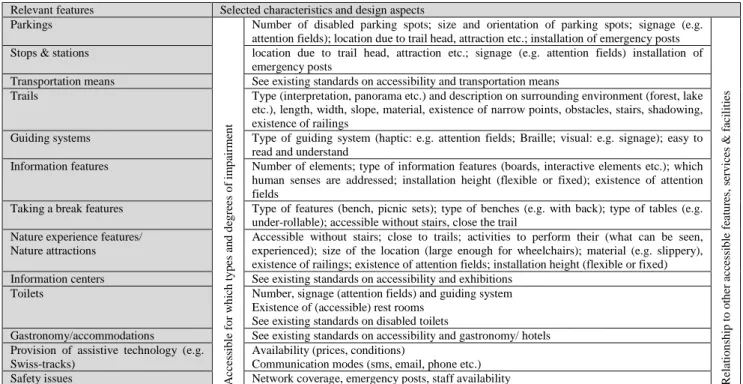
Relevant features Selected characteristics and design aspects Parkings A cc es si b le f o r w h ic h t y p es a n d d eg re es o f im p ai rm en t
Number of disabled parking spots; size and orientation of parking spots; signage (e.g. attention fields); location due to trail head, attraction etc.; installation of emergency posts
R el at io n sh ip t o o th er a cc es si b le f ea tu re s, s er v ic es & f ac il it ie s
Stops & stations location due to trail head, attraction etc.; signage (e.g. attention fields) installation of emergency posts
Transportation means See existing standards on accessibility and transportation means
Trails Type (interpretation, panorama etc.) and description on surrounding environment (forest, lake etc.), length, width, slope, material, existence of narrow points, obstacles, stairs, shadowing, existence of railings
Guiding systems Type of guiding system (haptic: e.g. attention fields; Braille; visual: e.g. signage); easy to read and understand
Information features Number of elements; type of information features (boards, interactive elements etc.); which human senses are addressed; installation height (flexible or fixed); existence of attention fields
Taking a break features Type of features (bench, picnic sets); type of benches (e.g. with back); type of tables (e.g. under-rollable); accessible without stairs, close the trail
Nature experience features/ Nature attractions
Accessible without stairs; close to trails; activities to perform their (what can be seen, experienced); size of the location (large enough for wheelchairs); material (e.g. slippery), existence of railings; existence of attention fields; installation height (flexible or fixed) Information centers See existing standards on accessibility and exhibitions
Toilets Number, signage (attention fields) and guiding system Existence of (accessible) rest rooms
See existing standards on disabled toilets
Gastronomy/accommodations See existing standards on accessibility and gastronomy/ hotels Provision of assistive technology (e.g.
Swiss-tracks)
Availability (prices, conditions)
Communication modes (sms, email, phone etc.) Safety issues Network coverage, emergency posts, staff availability
Table 2: Aspects of accessible recreational natural and man-made elements (from Hennig 2014b)
3.1.2 Tourism service chain
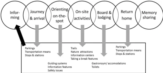
But, focussing on single elements is not enough. Comparable to journeys, visits to natural areas rely on the availability of various facilities and services that support all kinds of activities related to the stay. As presented in Fig. 1, this refers to (i) decision to visit the site and according organization (information incl. booking etc.), (ii) journey and arrival, (iii) familiarization with the destination on-the-spot (orientation, information), (iv) performing on-site activities and experiencing the destination (including mobility at the destination) (v) gastronomy , accommodation, shopping etc., (vi) return home (i.e. departure and journey), and (vii) memory-sharing (e.g. online). Elements related to these activities build up the so called tourism service chain (BMWi 2007; CA 2005; NatKo & VdN 2002). Here, it applies that only if attractive facilities and services are developed and implemented along the entire service chain, a complete service chain – as requirement for convenient holidays– exists. If one of the links in the service chain is broken or not suitable to the guest, then the visit may either end unsatisfactorily or may never happen (Bollich & Neumann 2005; Österreichische Bundesforste 2014).
Fig.1: Tourism service chain (adapted from Waiguny 207; URL 3)
The provision of a complete service chain is as relevant for recreational and/ or tourist visits to natural areas: Also visits to the outdoors require for infrastructure in terms of information, arrival, orientation, moving around, on-site experience, departure, and memory-sharing. Regarding recreational visits by the disabled, all facilities and services along the service chain must be barrier free. Here, if only one element is missing, this does not just mean discomfort and/ or inconvenience for the guest, but - in the worst case – that “the chain breaks” and that a person will not be able to visit a destination at all. Thus, for instance, if suitable transport is not available, then the visit is unlikely to happen (CA 2005; Österreichische Bundesforste 2014).
At that, it has to be highlighted, that the first link of the tourism service chain, which refers to the provision of off-site information, is of particular relevance. As already outlined – even though this is just one among many links – on this first link it depends, if the decision to visit a site is made or not.
in Natural Areas
3.2 Accessibility
Accessibility is defined as the ability to access the functionality and possible benefits of products, devices, services, or environments for people with disabilities. It describes the degree to which a building, outdoor area or other facility is accessible, i.e. can be entered and used by everyone – independently, without the need for special arrangements (EC 2004; URL 1).
Due to the growing relevance of ICT, accessibility today refers also to the accessibility of digital, i.e. web-based solutions. Described by the term web accessibility, it means that disabled people can perceive, understand, navigate, and interact with the Web, and that they as well can contribute to the Web. This asks for removing barriers that prevent access to websites by the disabled. Only if websites are correctly designed, developed, and edited, all users have equal access to information and functionality (URL 6).
In terms of web accessibility, digital assistive technologies play an important role. By definition assistive technologies is any object or system directed towards aiding disabled people in interacting with their environment in order to communicate with others and to accomplish a variety of tasks. With regard to digital products, it refers to technology that supports users in accessing and using software applications and websites, interacting with other technologies etc. Prominent tools are Braille display, Braille embosser, magnification software, optical character recognition, screen reader, and voice output. Among these, voice output, screen reader, Braille display, and magnification software are the most popular ones (Hennig et al. 2012; ITU/G3ict 2014).
3.3 Target group
The group of people asking for accessibility is not only large, but also quite heterogeneous: In the European Union, about 37 million people are considered of facing disabilities. If the definition includes other groups as well such as the elderly and further people requiring for accessibility due to several reasons, the number of people demanding for accessible environments is even greater. Thus, for instance, altogether, around 120 million disabled or elderly people in Europe would welcome improved access (CA 2005; EC 2004).
3.3.1 People with disabilities
People with disabilities include all persons that, due to physical, sensory, or cognitive impairment (which have a substantial and long-term adverse effect on a person’s ability to carry out normal daily activities), are challenged by barriers and obstacles that prevent them from fully participating in the world. At that, disabilities may be present from birth, or occur during persons’ lifetime (Atkinson & Castro 2008, URL 4). Barriers faced by disabled are as different as forms of impairment (Table 3).
Disability Barriers and obstacles
Wheelchair Stairs, steep ramps, vehicle boarding with stairs or other obstacles, narrow entrances, doors, passages missing space for turning the wheelchair,
handles, push-buttons, door latch or mountings can not be reached no roll-under tables, washbasins etc.
Reduced mobility
Long distances, overcome differences in level (stairs, ramps etc.), steep gradients etc.
Smooth, slippery surface of roads and sidewalks (in terms of unfavorable weather conditions), but also in buildings, leisure facilities etc.
Severity and/ or degree of the barriers varies depending on which type of assistive technology is used (e.g. walking stick, walking frame)
Arm/ hand Usage of railings, handles, push-buttons, door latch or mountings Visual Problems to orient themselves, navigate and find their way
Low-contrast visual information causes stumbling and increases accident risk
If information is not imparted in an auditory and/ or haptic manner, these people are lost
Hearing Acoustic signals can not be perceived; if acoustic signals are not transformed into visual ones, these persons are lost Since the deaf often suffer from disturbance of equilibrium and anxiety states, being in dark often causes problems for them Allergy Different materials, food, pollen (hay fever) etc.
Learning Problems to orient themselves in unfamiliar environments, and to use independently information as usually available due to missing reading and understanding skills
Mental Not-familiar, unknown environments; not knowing what they expect there
Table 3: Impairments and to this related barriers and obstacles (from Berdel et al. 2003)
3.3.2 The elderly
Owing to specific, age-related deficits and alterations (e.g. reduction in stamina, mobility and sensory, i.e. visual and auditory acuity) many elderly people face barriers and obstacles just as the disabled. Their number not only is currently increasing, but it is also expected to rise further in the future due to the so called demographic change, resulting in a greater proportion of older people in society (EC 2004).
3.3.3 Other groups concerned
Other groups calling for accessibility are for instance (CA 2005): (i) all those people who experience temporary impairments, such as a broken limb, a heart condition, or general fatigue, (ii) accompanying persons such as families, friends and carers, since the implications of the resulting disability are often shared by them, and (iii) families with kids, which due to e.g. baby buggies face barriers, too.
4 METHODS
To yield insight into the current status of accessibility of natural areas, and to develop recommendations on how to impart information as needed to the target group (in a way suitable for them), several methods were applied.
The research put particular focus on protected areas, which often serve as an example and have a role model function regarding e.g. the development of new solutions in terms of nature-based recreation. Further, especially protected areas are challenged by accessibility: On the one hand, providing great natural and scenic beauty as well as environmental attractions, they have the obligation to be open to the general public (including disabled persons as well) for purposes of visitation and recreation. On the other hand, these sites have the responsibility to conserve and protect their natural environments. Expansion of all kinds of infrastructure must be well thought of as it not only can have negative impact due to the construction of infrastructure, but also since it allows and encourages more people to visit the site. This might be not wanted because of aspects such as wildlife disturbance, erosion, littering, and crowding.
4.1 Literature Review
An extensive literature review was undertaken to identify, review and report on relevant aspects concerning the accessibility of natural areas. This refers to (i) accessibility standards and guidelines regarding digital and non-digital products, (ii) reports and documents prepared by natural as well as protected areas, experts and stakeholder groups as well as umbrella organizations (e.g. tourism and recreation, protected areas, disabilities), and (iii) scientific publications on e.g. recreation and tourism, disabled people and accessibility and barrier freeness of digital and non-digital products.
4.2 Survey of natural area
A survey was conducted among large protected areas, i.e. national parks, biosphere reserves and nature parks, in Germany, Austria and Switzerland (autumn 2014). The questionnaire contained of 17 questions. Here, mostly open questions were used since this allows for specific and precise answers, and it gives the respondents the opportunity to answer freely, without being constrained to a supplied frame of reference. Due to more detailed answers a direct view into a respondents own thinking can be given (Roberts et al. 2014). The questionnaire was prepared using the online questionnaire design tool Survey Monkey. The questionnaire was distributed using email.
From 197 large protected areas the questionnaire was sent to, 68 (mostly nature parks) participated. The data collected through the closed questions of the web-based questionnaire was pre-processed (e.g. data cleansing) and statistical analysis using MS Excel and IBM SPSS. Analysis of data retrieved from the open questions was done through human coding. Following Roberts et al. (2014), this involved several steps: First, guided by the researcher’s own prior theoretical expectations and reading of some examples, dimensions on which open data had to be coded were defined (i.e. coding categories). Second, human coders labeled responses with one or more coding categories. Third, once data had been categorized and coded, it was explained in terms of what is being said about the subject or theme. So, it became obvious to what categories are related, if and where trends and patterns exist, and if there are common themes emerging.
4.3 Analysis of analogue systems
Analysis of similar systems (AoSS) is a method well-known in the field of software engineering, requirements and usability engineering. Usually, this method is used to discover how others have addressed a related problem. Further, AoSS is applied to discover the most significant features of other products, i.e. systems that are similar to the product being generated. At that, all aspects of interest among existing similar systems are compared site-by-site based on criteria having the most direct implication for meeting system objectives. This creates an analysis that, on the one hand, is broad (due to the number of products reviewed),
in Natural Areas
and, on the other hand, is deep (due to the number of features compared). Through comparing different systems, one can yield insights on why one item may be better (e.g. easier to operate) than other items. Further, it allows spelling out the pro and cons of the different systems and merging meaningful as well as adaptive solutions into one’s own product (Nemeth 2004; URL 1).
Based on the questionnaire results, websites of a selection of large protected areas were studied in detail. Therefore an appropriate catalogue of criteria was elaborated. First, it focused on criteria related to aspects of web accessibility (i.e. in line with WCAG .0 principles), second, on kind of information offered to the target group including aspects such as position, visibility and findability of the information in the website as well as its structure, and, third - if available - on web-based maps (design, content, design, functionalities, linkage with other media such as verbal description of the map content).
5 RECOMMENDATIONS TO IMPROVE INFORMATION IN SUPPORT OF DISABLED PEOPLE’S RECREATION IN NATURAL AREAS
5.1 Web content accessibility
Even though, well-documented and well-approved standards of web accessibility exist (besides WCAG 2.0, ISO 28803, and EN ISO 9241 etc.), only a small number of protected area websites put these into practice. If considering the special needs of disabled people at all, focus is on visual impairments providing users concerned with the possibility to change font size, color and contrast as used in the website or to present content without images (c.f. Ötztal Nature Park, Austria). However, among the analysed websites particularly the solutions of Eifel and Harz National Park (both Germany) are outstanding due to accessibility. Both consider comprehensively WCAG 2.0 principles and guidelines. At that, the website of Harz National Park is priced with the BIENE award (Germany's most prestigious award for barrier-free design; URL 5).
As a basic principle, web applications today should pay attention to WCAG 2.0 to guarantee accessibility of its web content. This is a true for websites of natural areas. WCAG is a standard developed by the WordWideWeb Consortium (W3C) in cooperation with individuals and organizations around the world, with the goal of proving a single shared, internationally accepted standard for web content accessibility that meets the needs of individuals, organizations, and governments. The according documents explain how to make web content more accessible to disabled people. Web content refers to the information in a web page or web application, including natural information such as text, images, and sounds as well as code or markup that defines structure, presentation etc. In its second version, the WCAG has twelve guidelines that are organized under four principles (Table 4): being perceivable, operable, understandable, and robust. For each guideline, there are testable success criteria (URL 10). A short summary of the WCAG 2.0 guidelines is provided under URL 7; detailed information on web accessibility principles and guidelines can be found at URL 8.
Principle Guideline (Name) Guideline (Description)
Perceiv-able Information and user interface components must be presentable to users in ways they can perceive
1.1 Text alternatives Information and user interface components must be presentable in ways perceivable by users (e.g. verbal description on non-text content like images)
1.2 Time-based media Time-based media (audio, video): Provide alternatives for it (e.g. subtitle)
1.3 Adaptable Create content that can be presented in different ways (for example simpler layout) without losing information or structure
1.4 Distinguishable Make it easier for users to see and hear content including separating foreground from background (e.g. use of color, color contrast, audio control)
Operable User interface components and navigation must be operable
2.1 Keyboard accessible Make all functionality available from a keyboard 2.2 Enough time Provide users enough time to read and use content
2.3 Seizures Do not design content in a way that is known to cause seizures (e.g. red flashed) 2.4 Navigable Provide ways to help users navigate, find content, determine where they are
Under-standable
Information and the operation of user interface must be understandable
3.1 Readable Make text content readable and understandable (e.g. due to language) 3.2 Predictable Make web pages appear and operate in predictable ways (on focus, on input)
3.3 Input assistance Help users avoid and correct mistakes (due to labels or instructions; error identification) Robust Content must be robust enough that it can be interpreted reliably by a wide variety of user agents, including assistive technologies
4.1 Compatible Maximize compatibility with current and future user agents, including assistive technologies
In order to accommodate different situations that may require or allow greater levels of accessibility than others, the WCAG 2.0 distinguishes three levels of accessibility: A (lowest level; basic), AA (recommended) and AAA (highest level; ideal). Depending on the accessibility level, different WCAG 2.0 guidelines must be met by the particular website (URL 9).
5.2 Suitable information provision
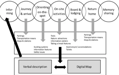
Due to the relevance of the tourism service chains for recreational and/ or tourist visits to natural areas (see section 3.1.2), it is important that information provided does not focus on single features only, but that it reflects all aspects of the tourism service chain (Fig. 2). Accordingly, barrier free services and facilities must be presented, and relevant characteristics have to be outlined in detail (as e.g. listed in Table 2).
Fig. 2 Information content and structure reflecting the tourism service chain in terms of accessibility
Here, it is important that information on accessible services and facilities is easy find. Analysis of protected area websites show that relevant information is often hard to discover. Thus, where to find information required by the disabled should be providing at first glance (e.g. top-level of navigation-hierarchy) and adequately labeled (Fig. 3).
Fig. 3: Example for easy-to-find information; Schwäbisch-Fränkischer Wald Nature Park (URL 2)
5.3 Accessible web-based maps
In protected area websites web-based maps play an important role in support of planning visits (in advance of a visit) as well as for orientation, navigation, and way-finding on-site (Hennig 2014).This is as true for
in Natural Areas
visits of disabled people to natural areas. However, only few protected area websites leverage web-based maps in order to communicate relevant (spatial) information to the visitors. If implemented they hardly pay attention to requirements of disabled people.
Based on the research results of several previous projects such as AccessibleMap recommendations giving guidance to develop and implement web-based maps exist. This refers to map picture design as well as range and properties of functions to be implemented – meeting in particular the needs of the visual impaired (c.f. Hennig et al.2012; Neuschmid et al. 2012). However, WCAG 2.0 recommendations provide relevant input in order to develop web-based maps to be accessible.
Regarding map content, information must reflect the tourism service chain. As shown in Fig. 4, it is important that the information related to the service chain is not only presented in the map, but that it also is verbally described (readable and/ or audible leveraging assistive technologies). This is in line with the first principle, first guideline of the WCAG 2.0 (provide text alternatives; Table 4). An example how this could look like is presented by the website of the German Meißner-Kaufunger Wald Nature Park (URL 13).
Fig. 4: Information content and structure reflecting the tourism service chain in terms of natural areas’ accessibility
6 CONCLUSION
Accessibility is a topic that natural areas pay increasing attention to. While on-site accessible services and facilities are available, there is a lack of off-site information. However, providing information on existing barrier free infrastructure is an important precondition for disabled people in order to decide to visit an area or not. Therefore, today, web-based solutions and particularly web-based maps (due to the spatial reference of recreational activities) play a key role. Information must be presented being in line with WCAG 2.0 principles and guidelines, and it must be easy-to-find (e.g. findable at first glance). Further, information content must follow the so called tourism service chain. Using web-based maps, these can be developed applying e.g. recommendations on accessible web maps (i.e. map design, range and characteristics of functions; verbal description on the map content being readable, hearable). But, this asks for an appropriate database. Data must be stored in a suitable data model allowing providing information on accessible services and facilities. Besides developing an appropriate data model, this requires for having digital data as needed at one’s fingertips.
Concerning the description and classification of accessible services and facilities in natural areas it is problematic, that on the one hand – even though barrier freeness plays a pivotal role for these sites – literature outlines a lack of standards on accessibility of the outdoors. On the other hand, there are no commonly accepted levels of accessibility like provided by the WCAG 2.0 regarding the accessibility of web content (distinguishing three conformance levels). Thus, there is urgent need for elaborating accessibility standards for natural areas and for defining accessibility categories. This might be very helpful when providing information to the target group.
7 REFERENCES
ARNADE, S. & HEIDEN, H.G.: Allgemeine Grundlagen. In: Barrierefreies Naturerleben vom Watt bis zum Watzmann. Dokumentation einer Tagung in der Brandenburgischen Akademie „Schloss Criewen“.2009.
ATKINSON, R.D. & CASTRO, D.D.: Accessibility for people with disabilities. In, Digital Quality of Life: Understanding the Personal and Social Benefits of the Information Technology Revolution. 2008
BERDEL, D.; GÖDL, D & SCHOIBL, H.: Qualitätskriterien im Tourismus für behinderte und ältere Menschen. Studie im Auftrag des Bundesministeriums für soziale Sicherheit, Generationen und Konsumentenschutz. 2003.
BITKOM (Bundesverband Informationswirtschaft, Telekommunikation und neue Medien e.V.): Apps & Mobile Services – Tipps für Unternehmen. Berlin, 2012.
BOLLICH, P. & NEUMANN, P.: Tourismus für ältere Menschen: Einflüsse auf das Mobilitätsverhalten und Anforderungen an die Infrastruktur. In: WILFRIED, E. (Hrsg.): Mobilität ältere Menschen, Strategien zur Sicherung der Mobilitätälterer Menschen, pp. 181-189. Köln, 2005.
BMWI (Bundesministerium für Wirschaft und Technologie): Economic Impulses of Accessible Tourism for all. Summary of Results. Berlin, 2007.
BMWI (Bundesministerium für Wirschaft und Technologie: Wassertourismus in Deutschland): Praxisleitfaden für wassertouristische Unternehmen, Kommunen und Vereine. Berlin, 2013.
CA (The Countryside Agency): By all reasonable means: Inclusive access to the outdoors for disabled people. 2005. DIBIASE, D.: Visualization in the Earth Sciences. Earth and Mineral Sciences Nr. 59 (2), pp. 13-18. 1990.
EBERLE, T.: Touristische Bedarfsanalyse und Implementierung eines WebGIS in das touristische Gesamtkonzept Nationalpark Bayerischer Wald. In: Angewandte Geoinformatik 2010. Beiträge zum 24. AGIT-Symposium, Salzburg. Wichmann, pp.339-347. Berlin, 2010.
EC (European Commission): Improving information on accessible tourism for disabled people. 2004.
GOLLEDGE, R.G. & STIMSON, R.J.: Spatial Cognition, Cognitive Mapping, and Cognitive Maps. In Spatial Behavior: A Geographic Perspective edited by G. Golledge, 224-257. New York, 1997.
HENNIG, S.: Innovative Wege für die Informations- und Kommunikationsarbeit im Naturschutz – vorgestellt am Beispiel von Großschutzgebieten. In, ANLiegen Natur 36/, pp. 90 – 102. 2014a.
HENNIG, S.: Barrierefreie Erholung bzw. barrierefreier Tourismus in Natur und Landschaft: Charakterisierung der Zielgruppe sowie der Anforderungen an Informationsbedarf und -darstellung. Report WP 1 senTOUR Project (unpublished), 2014b. HENNIG, S.; OSBERGER, A.; NEUSCHMID, J.; SCHRENK, M.; WASSERBURGER, W. & ZOBL, F.: Providing Web Maps for
Everyone. Understanding Users and their Requirements. In: Proceedings REAL CORP 2012. Pp. 627-635. 2012. IEB (Institute of Electronic Business e. V.: Digital Natives – Generation Internet. 2009
(www.ieb.net/newsletter/46/dl/digital-natives_artikel.pdf; 17.02.2015).
IMMOOS, U. & HUNZIKER, M. (2015): The effect of communicative and on-site measures on the behaviour of winter sports participants within protected mountain areas – results of a field experiment. In, eco.mont - Volume 7, Number 1, January 2015, pp. 17-25. 2015.
ITU/G3ICT (International Telecommunication Union/ Global Initiative for Inclusive ICTs): Basic Accessibility Principles. ITU/G3ict. Accessed March 19. 2014
(http://www.e-accessibilitytoolkit.org/toolkit/eaccessibility_basics/basic_accessibility_principles; 17.02.2015).
JURCZEK, P.: Freizeit- Tourismusplanung. In C. Becker, H. Hopfinger, A. Steinecke (Hrsg.), Geographie der Freizeit und des Tourismus, pp. 730-740. München, Wien, 2003.
SWARBROOKE, J. (2001): Sustainable tourism management. In, International Journal of Tourism Research. Volume 3, Issue 1, pp. 89–90. 2001.
MEA (Meetings & Events Australia): Accessible Events. A Guide for meeting and event organisers. 2012.
MECKEL, M.: Aus Vielen wird das Eins gefunden - wie Web 2.0 unsere Kommunikation verändert. - Politik u. Zeitgeschichte 39. 2008. (http://www.bpb.de/apuz/30964/aus-vielen-wird-das-eins-gefunden-wie-web-2-0-unsere-kommunikation-veraendert?p=all; 17.02.2015).
NATKO & VDN (Nationale Koordinationsstelle Tourismus für Alle & Verein Naturparke Deutschland): Naturparke für Alle – Barrierefreies Naturerleben in Deutschland. Düsseldorf, 2009.
NEMETH, C.P.: Human factors for design: making systems human centered. CRC Press, 2004.
NEUSCHMID, J.; HENNIG, S.; SCHRENK, M.; WASSERBURGER, W. & ZOBL, F.: Barrierefreiheit von online Stadtplänen: das Beispiel AccessibleMap. In: Angewandte Geoinformatik 2012. Beiträge zum 24. AGIT-Symposium, Salzburg. Wichmann, pp.339-347. Berlin, 2012.
ÖSTERREICHISCHE BUNDEFORSTE: Naturerleben für Alle. Ein Leitfaden zur Gestaltung barrierefreier Naturerlebnispunkte. 2014.
ROBERTS, M. et al. (2014): Structural Topic Models for Open-Ended Survey Responses. In: American Journal of Political Science, Vol. 00, No. 0, pp. 1–19. 2014.
WALZ, S.; KAST, A.; SCHULZE, G.; BORN, L.; KRÜGER, K. & NIGGERMETER, K.: Handbuch zur Partizipation. − Senatsverw. Stadtentw. u. Umwelt. Berlin, 2011.
WAIGUNY, M. (2007): Erfolg durch eTourism. 2007 (http://slideplayer.de/slide/863556/; 17.2.2015) URL 1: http://www.disabled-world.com/disability/accessibility/#sthash.nM8zsmZK.dpuf (17.2.2015) URL 2: http://www.naturpark-sfw.de/Barrierefrei.1278.0.html (17.2.2015) URL: 3: http://www.natko.de/index.php/reiseinfos (17.2.2015) URL 4: www.un.org/apps/news/story.asp?NewsID=48004 (17.2.2015) URL 5: www.biene-award.de/ (17.2.2015) URL 6: http://www.w3.org/WAI/intro/accessibility.php (17.2.2015) URL 7: http://www.w3.org/WAI/WCAG20/glance/ (17.2.2015) URL 8: http://www.w3.org/WAI/intro/people-use-web/principles (17.2.2015) URL 9: http://www.w3.org/TR/UNDERSTANDING-WCAG20/conformance.html (17.2.2015)
in Natural Areas
URL 10: http://www.w3.org/WAI/intro/wcag (17.2.2015)
URL 11: http://acrl.ala.org/techconnect/?p=2020http://acrl.ala.org/techconnect/?p=2020 (17.2.2015) URL 13: http://www.naturpark-mkw.de/barrierefrei-hoher-meissner (17.2.2015)