Observatons on the littoral algae of the Isle of Wight
12
0
0
Full text
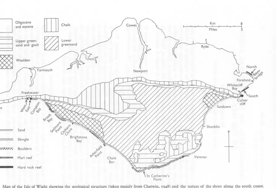
(2) Km I. " M;les '. 8 ". ~. Freshwater. q. -"'W':'-". J t ...~~. ., •..• n. Needles. ~'" ~ '<i. f:";:\. 00. Q:;'". ,'". o~o~~. 'v",<"~",. .•x,••·,·,...•••••••• Sand. '.,"'«.0 ~'$'. C; 0"'" Brighstone Bay. ',..",""'n· ...·... Shingle. ••••••••••••. Boulders. ~. Marl reef. -. Hard. rock. Chale Bav reef. .~'j:.~rrr:~""-"W;;; ••. \ St Catherine's Point. Fig. I. Map of the Isle of Wight showing the geological structure (taken mainly from Chatwin, 1948)and the nature of the shore along the south coast. The arrows indicate the positions of transects..
(3) ALGAE OF THE ISLE OF WIGHT. 77I. and Wealden, the lowest beds being exposed at about Sedmore Point. The series then ascends to St Catherine's Point. The south-east coast shows a similar sequence passing north-eastwards, the lowest beds being exposed in Sandown Bay. The southern limb of the anticline has a gentle slope, and where the Chalk reappears inland of St Catherine's Point the beds are almost horizontal. The soft underlying Gault has resulted in large sections of these Downs slipping down. GENERAL. SURVEY. A general survey of the type of shore and the distribution of the principal algae was made by walking along the shore and noting the substrata and the species present. Only the southern coast was studied. The northern shores are mostly of mud or sand, with some boulders in places. From the Needles to Freshwater the cliffs of hard Upper Chalk drop almost sheer down to the sea. On either side of Freshwater Bay there are hard Chalk reefs which support fairly rich algal communities. These were studied with the use of transects (p. 775). The Middle and Lower Chalk cliffs of Compton Bay have boulders at their bases. Below the narrow belts of Upper Greensand, Gault and Lower Greensand the shore is sand or shingle. From the centre of Compton Bay to Sedmore Point most of the shore is occupied by a grey and purple Wealden Marl reef. This rock is smooth and very soft, but a number of algae are able to colonize it. The most common are Polysiphonia nigrescens, Corallina officinalis and Cladostephus spongiosus. Cladophora, Fucus vesiculosus, F. serratus, Ceramium rubrum, VIva lactuca, Rhodochorton and some diatoms are also present. From Sedmore Point to the centre of Brighstone Bay is mostly sand except for a hard reef opposite Chiltern Chine. This supports a flora similar to that on the Marl, with the exception of Polysiphonia nigrescens, but with. the addition of Lomentaria articulata, Chondrus crispus, Rhodymenia palmata, Laurencia pinnatifida, Furcellaria fastigiata and Ptilota plumosa. The Marl reefs of Brighstone Bay are for the most part covered with sand and support no algae. The hard reef off Atherfield Point was not accessible when it was visited but clearly supported fucoids. Chale Bay has a beach of fine sand and shingle. Between St Catherine's Point and Ventnor the shore is strewn with boulders, sometimes forming a complete covering and sometimes mainly in the bays, in patches alternating with sand or shingle. There is usually a band of shingle at the top of the beach just below the cliff. The boulders support fairly extensive algal communities. The more detailed study of St Catherine's Point was of a fairly representative section (p. 775). The shore between Ventnor and Shanklin was not visited. From there to the beginning of Culver Cliff, where the Chalk reappears on the shore, is sandy. Boulders lie at the base of the cliff and a Chalk reef extends from it. This supports a fairly extensive flora. Just north of the sand of Whitecliff Bay.
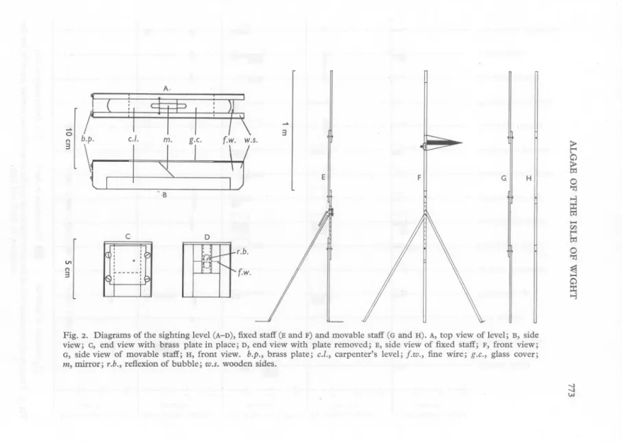
(4) 772. JOANNA M, KAIN. the ledges of Bembridge Limestone around the Foreland begin. These are more extensive on the south side than the north, where there is a greater proportion of sand. Both places were studied in more detail (p. 776). Of the 25 miles of coast visited, 9 miles have hard reefs or boulders and 3 miles have Marl reefs. The rest of the coast is sandy. SHORE TRANSECTS Five shores were selected for more detailed study by means of transects: the Chalk boulders west of and the Chalk reef east of Freshwater Bay, the boulders below St Catherine's Point lighthouse, some limestone reefs north of WhiteclifI Bay (' Bembridge South') and limestone reefs at Bembridge Point (' Bembridge North '). These are marked in Fig. I. Levelling apparatus. A simple form oflevelling apparatus was developed for the use of the singlehanded worker. As it is very cheap to assemble it will be described in some detail. The sighting level is shown in Fig. 2A-D. It consists of a carpenter's level with wooden sides added to support a partly silvered piece of glass (to reflect the bubble) in the centre, a fine wire horizontally across one end and a brass plate, with a pinhole, across the other end. In order to adjust the sighting line between the hole and the wire so that it is parallel to the level itself, the brass plate is moved up or down until readings of height taken in opposite directions with the instrument are identical. It is usual with this type of instrument to have it at a fixed height and to read the height on a staff in the position to be measured. But as this involves another worker holding the staff the proceeding has been reversed: the staff is fixed in one position with a clear triangular marker, and the heights of the positions to be measured are determined by sliding the instrument up or down a graduated movable staff until it is level with the marker and then reading its height on the movable staff. The fixed staff is shown in Fig. 2E, F. It is constructed mainly of 0,6 m lengths of 1'2 x 2 cm wood bolted together in such a way that it can be folded to a length of 0'7 m. The staff is 2'1 m high and is marked at 0'5 m intervals from the ground. The pointer can be attached at any of the four marks by means of a bulldog clip. The staff is held upright by two legs, each a metre long and with a hinge at the top end which can be bolted through any of a number of alternative holes. It can thus be set up on uneven ground. The bottom ends of the legs and the staff itself have strap hinges with flat pieces of leather attached. Stones can be placed on these so that the whole is stable and rigid. The movable staff is shown in Fig. 2G, H. It is marked in centimetres..
(5) A-. ~. on. I ( :~,. i. r\. 3. 3 F. '\ ~' * 't. r.y'. - ·B. c. CIl t'" •....• ':r:I t'" •....• :::r: >-3 >-3. tIj ~ tIj s:;. 0. II. H II. 0. G II. >. E. D , ,. <n. n. 3. ,. ,. C' ,-,. r.b.. [J], .: lEn, ~-----~,. :,. ,. Fig. 2. Diagrams of the view; c, end view with G, side view of movable m, mirror; r.b., reflexion. r-"~. fw.. sighting level (A-D), fixed staff (E and F) and movable staff (G and H). A, top view of level; B, side brass plate in place; D, end view with plate removed; E, side view of fixed staff; F, front view; staff; H, front view. b.p., brass plate; c.Z., carpenter's level; f.w., fine wire; g.c., glass cover; of bubble; w.s. wooden sides. --.J --.J. W.
(6) •. "» " ""z"0 0 "0 if ~j. -< c(1)::J::;...,...,., 0...., (1) ..• '" "I1..0 c0a3 -cc::J(1)::J...,..., ...,., ..., ...• ..• ...• ..• '0:4 '" (1) =''0 () (Jq ::>" ...,., f;: < 0. i:l =' ., '" '"C>:; < f;: ~O. E.Dl 0., ::l. f;: 00l!. ~o t=.:g ::t () <> 0'"!:r0'8() §~ 0." ..• <,;' ~S ';<l 5' ~. 8 g .0 ':... <:> tJ S'. ~. Bembridge (north) metres "-'. w. Bembridge (south) metres "-'. 5t Catherine's metres "-'. Point. Freshwater (east) metres "-'. Freshwater (west) metres. w. "-'. Lomentaria articulata Chondrus crispus Corallina officinal is Lithothamnion spp. U/othrix flacca. w. Z Z0 ~. -..l .j:o. •...... Ceramium rubrum U/va /actuca Rhodymenia sp palmata .sppa/ata . Cladophora Enteromorpha L. Polysiphonia pinnatifida nigrescens Membranoptera Dictyota Laurencia dichotoma hybrida. ~ ~. -..l. .....•.
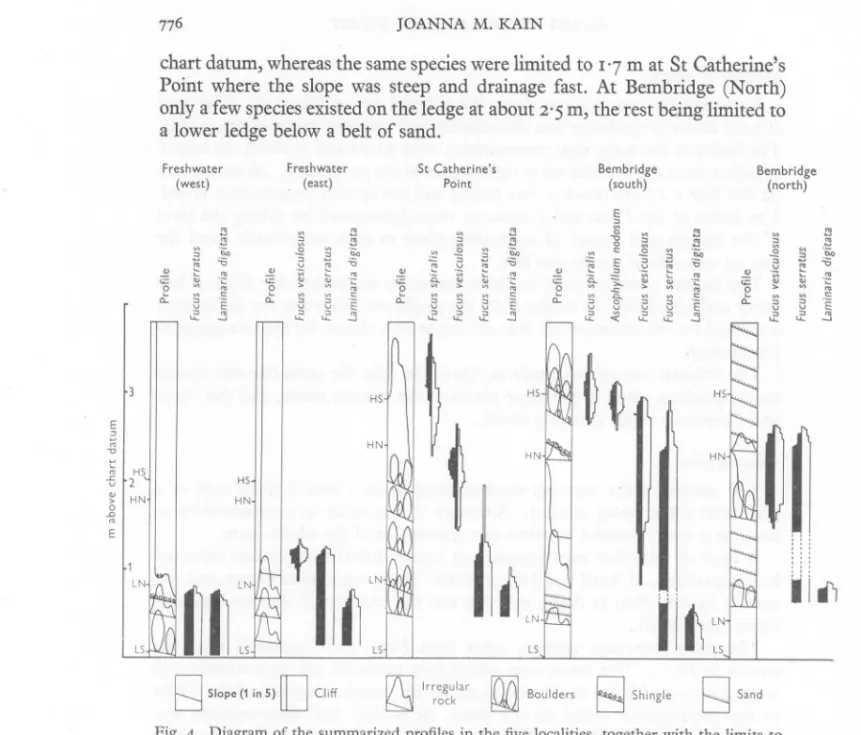
(7) ALGAE OF THE ISLE OF WIGHT. 775. Method of survey. A marked line was run out down the selected part of the shore. The level of each major irregularity was determined and sketches made of the profile. The limits of the main algal communities were noted and at about the centre of each a 10 m line was placed at right angles to the profile line. At each metre on this line a 252 cm quadrat was placed and the species present in it noted. The limits of the Fucus and Laminaria were determined by taking the level of the highest and lowest (if accessible) plant in each metre-wide band for 5 m on one side of the profile line. The heights were referred to chart datum by measuring the level of low water and calculating its height from the predicted low water for the locality corrected for the deviation on that particular day, shown by the tide gauge at Portsmouth. The original survey was made in April. In July the same line was visited again, quadrats taken in the same places to the nearest metre, and the Fucus and Laminaria zones similarly noted. Observations. The nature of the transect method resulted in a very limited area of a particular shore being studied. Although it was made as representative as possible it clearly cannot be taken as a description of the whole shore. A total of sixty-five macroscopic and twenty-five diatom species occurred in the quadrats, in April and July together. There were more brown and red species in July than in April, and this was the true for all the five locations taken individually. The most important species, other than Fucus and Laminaria spp., are shown in Fig. 3. The levels over which they extended are approximate and were determined from the levels (given by the profile diagram) of the limits of the communities noted on the shore. It is clear that Enteromorpha was very much more abundant in July than April. Dictyota dichotoma, Ceramium rubrum and possibly Laurencia hybrida were also more abundant in July. In addition to these Leathesia difformis, Cystoclonium purpureum, Ceramium ciliatum and C. diaphanum occurred in a number of quadrats only in July. The distribution of the other species shown was similar in July to that in April, especially that of Corallina officinalis and Lithothamnion. At Freshwater the height to which the species could extend seems to have been limited by the nature of the substratum, which was sheer cliff above 1 m. The exposed nature of the shore probably rendered this uninhabitable. The species therefore all had similar ranges. At St Catherine's Point the higher boulders were occupied by Enteromorpha and Ulothrix, other species extending up to about mid-tide. At Bembridge (South) it may have been the flat slow-draining ledge which enabled many species to extend to 2'2 m above 50. JOURN. MAR. RIOL. ASSOC. VOL. 37,. 1958.
(8) JOANNA. ~ " ~. "-. rn. chart datum, whereas the same species were limited to 1'7 m at St Catherine's Point where the slope was steep and drainage fast. At Bembridge (North) only a few species existed on the ledge at about 2'5 m, the rest being limited to a lower ledge below a belt of sand. ~Point ~ '"" Freshwater v E0 "-''i3E"~a.~~~e w:~ '"St 0 ."0 ~>"'"~.~ -' ~-c -2 Freshwater Catherine's a~ ~ ~ ~ aE "'i3 ~ ~ ~ (east) e Bembridge 3~ ~ a Bembridge ~ (south) (north) ~ ~ ~~ E '" rrn n rn ""0b"" 0b"" to. v. e. M, KAIN. 1. (west). ""-. rn rnrnrn. "rnrn rn rn. "- rn. '"b"". 1. "<= '". '" rn 00;;:. "-. rn. '""-. rn 0b"". rn. ;;:. .:;:. to. rn. HS~~. 2E>. L. HS. rn. HN. ~. 2. HN. HS. "'~~t ~ ~. ::~. ~lS ~. ~. " A,. I i. ~. IN lS. Q. Slope (1 in 5) []. Cliff. U. r7\llrregular rock. 1717\1 Boulders ~. n ~. Shingle. g. Sand. Fig. 4. Diagram of the summarized profiles in the five localities, together with the limits to which the fucoids and Laminaria extended, in April and July. HS,HN, mean high water springs and neapSj LN, LS, mean low water neaps and springs. See text for further explanation.. The fucoid and Laminaria zones are shown in Fig. 4, Included with them are the diagrams summarizing the profile of each shore. These were constructed from profile drawings in which the horizontal scale was a fifth of the vertical. The slope is thus much steeper than in reality. Each line representing the slope on the diagram refers to the region above the line, and the type of shore in that region is indicated diagrammatically. The existence of Fucus spiralis at Freshwater was probably precluded by the exposed nature of the vertical cliff at the level it would have occupied. It was present on another part of the shore where there were boulders at this level. On the east side F. vesiculosus occupied the tops of the rock irregularities,. III.
(9) ALGAE OF THE ISLE OF WIGHT. 777. while the flatter parts were dominated by F. serratus. At St Catherine's Point four zones were present, but the shore was apparently too exposed and steep for Ascophyllum. The steepness was presumably responsible for preventing Fucus serratus from extending higher, as it did on the gentle slopes of the Bembridge shores. At Bembridge (South) Ascophyllum was also present on the flat reef, but Fucus vesiculosus extended farther down the steeper part, where the surf was probably too strong for Ascophyllum. Here the upper limit of Laminaria was lower than at the other places, as a belt of sand prevented its extension upwards. Sand also severely limited zone-formation on the northern Bembridge shore, Fucus vesiculosus and F. serratus occupying the upper ledge. A complete list of the species encountered is given in Tables I and 2 (pp. 779-80). The frequencies in the quadrats of the macroscopic forms are given (Table I). Finally it must be said that no definite conclusions can be reached on the factors determining the distribution on these shores without more prolonged observations or experiments. It is possible that similar studies made after several years might reveal important differences in the distribution of many species. My thanks are due to Mr A. C. Kain for the design and construction of the levelling apparatus and to the Hydrographer (Admiralty) and the Assistant Queen's Harbour Master, Portsmouth, for tidal information. I am also indebted to Dr E. M. Burrows, Dr P. J. Dixon, the late Dr K. M. Drew Baker, Dr N. I. Hendey, Dr and Mrs D. E. G. Irvine and Dr M. W. Parke for the identification of various algae. Dr Hendey was entirely responsible for the identification of the diatoms given in Table 2, and I am extremely grateful to him. SUMMARY. The southern coast of the Isle of Wight, though mainly sandy, is composed in parts of marl reefs bearing a few algae and in other parts of boulders or hard reefs which bear full algal zonation. Transect and quadrat studies showed that in 1955 there were more species present in July than April and several species showed a marked increase in cover in July. The vertical distribution of the common species showed little change. The levels or existence of the fucoid zones are dependent on the slope of the substratum. A levelling technique suitable for single-handed work is described.. 50-Z.
(10) JOANNA M. KAIN REFERENCES CHATWIN, C. P., 1948. British Regional Survey. The Hampshire Basin and Adjoining Areas. London: Her Majesty's Stationery Office. DELF, E. M. & GRUBB, V. M., 1923. Marine algae. Proc. 1.0.W. nat. Hist. Arch. Soc., Vol. I, pp. 181-5 .. HENDEY, N. I., 1954. A preliminary check-list of British marine diatoms. J. mar. biol. Ass. U.K., Vol. 33, pp. 537-60. MOREY, F., 1909. A Guide to the Natural History of the Isle of Wight. London: W. Wesley. NORKETT, A. H., 1947. Marine algae of the Isle of Wight. Proc. 1.0.W. nat. Hist. Arch. Soc., Vol. 4, pp. 59-60. PARKE, M. W., 1953. A preliminary check-list of British marine algae. J. mar. biol. Ass. U.K. Vol. 32, pp. 497-520..
(11) ---- --. - - - - - - -. 220 1IS I12 I406284 6583 + + 2523 II 23 14 20 22 10 18 II 35 310 13 68114 IIS.E. 20 16 60 20 II + 20 ~ 27 16 25 Bemb.-N. 24 44 24 28 4 + 4° 4° 43 12 ~ Bemb.-S. 3° 7348St Cath. 3 47 35 335 29 3° 726 34 38 33 17 454 4° 28 77 5° 17 13 9° 87 S.W. F.W.-E. + 54 37 23 4° 13 67 17 93375465206 9° WIGHT 50 310 Apr. July Apr. 49 35 +637 36 Apr. 67 13 3° 13 17 3° 73ALGAE OF THE ISLE OF 779 Plocamium coccineum quadrats taken at that place. East N.) (F.W.-E), in April and from July. Compton The occurrence Bay to Brighstone in quadrats Bay is (S.W.), expressed at St asCatherine's a percentage Point of the (St. total Cath.), number from of St Catherine's Point to Ventnor (S.E.), at Bembridge South (Bemb.-S.) and at Bembridge North (Bemb.F.W.-W. s (other than diatoms) recorded in this work at Freshwater West (F.W.-W.), Freshwater TABLE 1. LIST OF ALGAE.
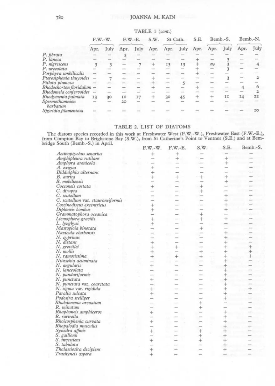
(12) ---. P.lanosa barbatum F.W.-W.. -. -. -. 2 1 0 + + 22 6+ 10 +Apr. I45 I02473Bemb.-S. 3St Cath. + ,--------A----,--------A----,--------A----3 S.W. S.E. Bemb.-N. F.W.-E. 29 14 17 30 13 53 Apr. 3 Apr. July 13 7 780 Spyridiafilamentosa. TABLE. -. JOANNA. M. KAIN. 1 (cont.). ---. -. -. -. +S.E. Bemb.-S. F.W.-E. S.W. TABLE 2. ++ LIST OF+ DIATOMS urita binotata F.W.-W. ilans ulphia alternans togloia South Bay (Bemb.-S.) to Brighstone in April. Bay (S.W.),Freshwater from St Catherine's Point to Ventnor (S.E.) and at BemThe diatom species recorded from in bridge thisCompton work at Freshwater West (F.W.-W.), East (F.W.-E.),.
(13)
Figure
Related documents
• Follow up with your employer each reporting period to ensure your hours are reported on a regular basis?. • Discuss your progress with
Income maintenance issues provide a good opportunity to show how the economist’s standard leisure-income model sheds light on the labor supply incentives of welfare. It is also a good
The corona radiata consists of one or more layers of follicular cells that surround the zona pellucida, the polar body, and the secondary oocyte.. The corona radiata is dispersed
Long term treatment with only metformin and pioglitazone and in combination with irbesartan and ramipril significantly ( P <0.001) reduced elevated serum
4.1 The Select Committee is asked to consider the proposed development of the Customer Service Function, the recommended service delivery option and the investment required8. It
multidimensional analysis between learner and professionally-written texts could be performed using data collected at data point 2 (the first assessed written task) and the
National Conference on Technical Vocational Education, Training and Skills Development: A Roadmap for Empowerment (Dec. 2008): Ministry of Human Resource Development, Department
19% serve a county. Fourteen per cent of the centers provide service for adjoining states in addition to the states in which they are located; usually these adjoining states have
