549
Earth Science
Introduction to Chapter 29
Slow, powerful processes are involved in recycling and moving rocky material from place to place on the planet. Deep within Earth, magma rises up and erupts on to the surface. When cooled, this molten rock may become a hand-sized piece of rock, part of a volcanic mountain, or part of the sea floor. Erosion of the land by water, wind, and glaciers is another way that matter moves from place to place. Erosion removes particles off rocks and minerals and moves them to another place where they may become another rock formation. The movement of tectonic plates on Earth’s surface can cause rock to be pulled back into the mantle or fold into mountains. The rock cycle summarizes the history of rocks and rock formations.
Investigations for Chapter 29
This Investigation expands your understanding of volcanoes. You will be given information about active volcanoes and their magma composition. You will use this information to predict the geographic location of an active volcano.
The surface of Earth has endured a lot of erosion over it’s 4.6-billion year history. By comparison, the moon’s surface has remained relatively unchanged over this time. In this Investigation, you will count the number of meteor impacts for a region of the moon and extrapolate those effects for Earth.
In this Investigation, you will simulate the processes that lead to the formation of the three main kinds of rocks—igneous, sedimentary, and metamorphic. You will also practice interpreting rock formations.
29.1 Volcanoes Why do some volcanoes erupt explosively?
29.2 The Surface of Earth How have meteors affected Earth’s surface?
29.3 Rocks and Minerals How can we interpret the stories within rocks?
550
Learning Goals
In this chapter, you will:
D Learn about the role of plate tectonics in causing volcanoes and learn what causes eruptions to be gentle or highly explosive.
D Identify the main types of volcanoes: shield volcanoes, stratovolcanoes, and cinder cones.
D Learn about other forms of volcanic activity such as geysers, hot springs, hydrothermal vents, and geothermal energy.
D Learn about the constructive and destructive processes on Earth’s surface like mountain-building, and erosion by wind, water, and ice.
D Learn how to interpret and use geologic hazard maps.
D Understand human impacts on Earth’s surface such as urban sprawl.
D Learn how to identify the three main kinds of rocks: igneous, sedimentary, and metamorphic.
D Learn how to identify common minerals using Mohs hardness scale.
D Apply your understanding of the rock cycle to explain the properties of rocks and to interpret rock formations.
Vocabulary
caldera geothermal energy metamorphic rock soil profile cinder cone volcano glacier mineral stratovolcano cleavage plane hydrothermal vent Mohs hardness scale urban sprawl crater igneous rock Ring of Fire vent
erosion lava rock cycle weathering fault-block mountain magma sedimentary rock
551
29.1 Volcanoes
Figure 29.1: Mount St. Helens before and after its eruption. Images courtesy of USGS/Cascades Volcano Observatory.
Travel to Earth’s core
In 1864, Jules Verne wrote “Journey to the Center of Earth.” In this fictional tale, the characters begin and end their travels by entering and exiting a volcano. As you might imagine, a journey to the center of Earth, if it were possible, would involve enduring extremes of temperature and pressure. Earth’s core is about as hot as the sun. The pressure would be very great because of the huge weight of rock layers.
29.1 Volcanoes
The eruption of Mount St. Helens in 1980 reduced the height of this mountain in southwest Washington state from 2,932 meters (9,677 feet) to 2,535 meters (8,364 feet) (Figure 29.1). Before then, scientists had monitored earthquake tremors and closely watched the development of a huge bulge at the top of the mountain. Early in the morning of May 18, 1980, an earthquake triggered a landslide that caused the bulge to eject magma, water, and gases.
Mount St. Helens provided scientists with an opportunity to see what happens before, during, and after a volcanic eruption. Why do you think recording earthquakes was a good way to monitor the mountain before it erupted? What do you think caused the bulge on the top? In this section, you will learn the answers to these questions and more about volcanoes.
What is a volcano?
Magma and lava Volcanoes are sites where molten rock and other materials from Earth’s mantle are released. Molten rock below Earth’s surface is called magma. The magma that reaches the surface and erupts out of a volcano is called lava. Volcanoes also release gases and rock fragments into the air. Large rock fragments are called
pyroclasts.Dust particle-sized fragments are called ash.
Parts of a volcano Magma is less dense than Earth’s crust so it naturally rises and enters cracks in the surface. Below ground, magma pools in pockets called
magma chambers. The pathways that magma takes to Earth’s surface are called pipes. Areas where magma reaches the surface are called
vents. A flank eruption occurs on the sides of a volcano where lava spills out of a vent. With each eruption of a volcano, layers of lava and ash build up and form a volcanic mountain. A
552
How magma forms
The mantle is made of solid rock
The mantle is composed of very hot, rocky material that moves in very slow convection currents. For the most part, this rocky material is in a solid form even though it is very hot in the mantle. This solid rock melts and becomes magma under certain conditions that lower the melting point of the material (Figure 29.2).
Decreased pressure lowers the melting point
The high pressures in the mantle prevent melting. However, because of convection currents, pressure decreases occur, especially near the mid-ocean ridges. At these locations, the rocky material can rise and replace the lava that is becoming new sea floor. Sea-floor spreading creates a void that gets filled by magma from the mantle. This process affects the deeper mantle by causing a decrease in pressure. The first stage of melting is called partial melt. The rocky material experiences partial melt because it is composed of various minerals, each with a different melting point. When the minerals melt, the resulting magma is less dense. This is another factor that contributes to magma being able to rise to Earth’s surface.
The addition of water lowers the melting point
At subduction zones, water is the key for solid rock to melt and become magma. When subduction occurs, some water is brought in with subducted sediments. Water is also evaporated from minerals like hornblende. The water lowers the melting point of surrounding rock so that magma forms. In other words, the addition of water means that rock will melt and become magma at a lower temperature. Because of water, subduction zones are sites of volcanic activity. The Ring of Fire is the result of subduction zones surrounding much of the Pacific Ocean.
Figure 29.2: This table summarizes the conditions under which the rocky material in the mantle is solid or melted. Rocky material melts and becomes magma when the pressure is lowered or when water is present.
Solid rock Melted rock (magma)
High pressure Low pressure
No water Water
Volcanic eruptions
553
29.1 Volcanoes
Where do volcanoes occur?
As with earthquakes, most volcanic activity is found at the edges of tectonic plates, namely at divergent and
convergent plate boundaries. Unlike earthquakes, volcanic activity does not occur at transform plate boundaries. The mid-ocean ridges, where plates diverge, are like very long volcanoes. Volcanoes also occur at convergent plate boundaries such as where one plate subducts under another.
Most volcanic activity is associated with plate
boundaries. About half of Earth’s active
volcanoes occur within the Ring of Fire.
The Ring of Fire
About half of the active volcanoes on Earth occur along the boundary of the Pacific Ocean. This region, called the Ring of Fire, includes both volcanic activity and earthquakes. The Ring of Fire coincides with regions where the oceanic crust of the Pacific plate is subducting under other plates. The graphic at left shows how volcanoes (represented by the blue dots) are associated with plate boundaries.
554
Features of volcanoes
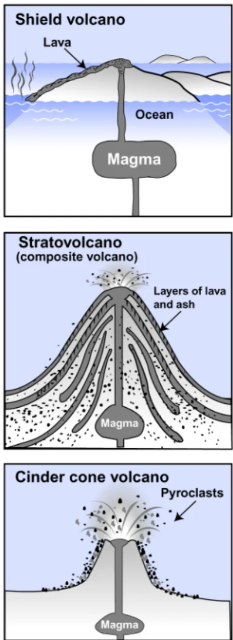
Viscosity of lava The shape of a volcano depends on the material that comes out of it. Volcanoes emit lava, pyroclasts, ash, and gases. Most importantly, the shape is related to the thickness or viscosity of the lava. Viscosity is a measure of a fluid’s flow rate. Fluids with high viscosity flow slowly. Fluids with low viscosity flow quickly. Lava’s viscosity depends on how much silica it contains. The higher the silica content, the greater the viscosity of the lava.
Types and shapes of volcanoes
Low viscosity, fast-flowing lava is associated with shield volcanoes. Because this lava easily flows down hill, shield volcanoes are gently sloped and flattened. In general, these volcanoes range in height from 500 to 10,000 meters high. High viscosity lava is associated with stratovolcanoes (also called composite volcanoes). Stratovolcanoes are cone-shaped, steep-sided mountains made of layers of lava and ash. These volcanoes are around 3,000 meters high. Cinder cone volcanoes are steep stacks of loose pyroclasts (clumps and particles of lava). Cinder cones are rarely higher than 300 meters.
The explosiveness of a volcano
Lava viscosity also determines how explosive an eruption will be. Explosive eruptions occur when the lava has a lot of water and dissolved gases (carbon and sulfur dioxide and hydrogen sulfide). This happens when lava is very viscous, as in cinder cones and stratovolcanoes. These volcanoes occur on the continents so their lava contains dissolved granite-like rock (called andesite and rhyolite) that is high in silica. Gentle eruptions are associated with fast-flowing lava from oceanic crust. This lava contains basalt which has less silica, less water, and fewer dissolved gases. Shield volcanoes produce this kind of lava.
Descriptions of lava
Silica content Low (45-54% silica) High (54-73% silica)
Rock composition Melted basalt Melted granite-like rock (andesite or rhyolite) Viscosity Low: flows quickly (~16 km/hour) High: flows slowly
Kind of eruption Gentle; less water and dissolved gas Explosive; more water and dissolved gas Associated volcanoes Shield volcanoes Stratovolcanoes and cinder cones
555
29.1 Volcanoes
Shield volcanoes
More about shield volcanoes
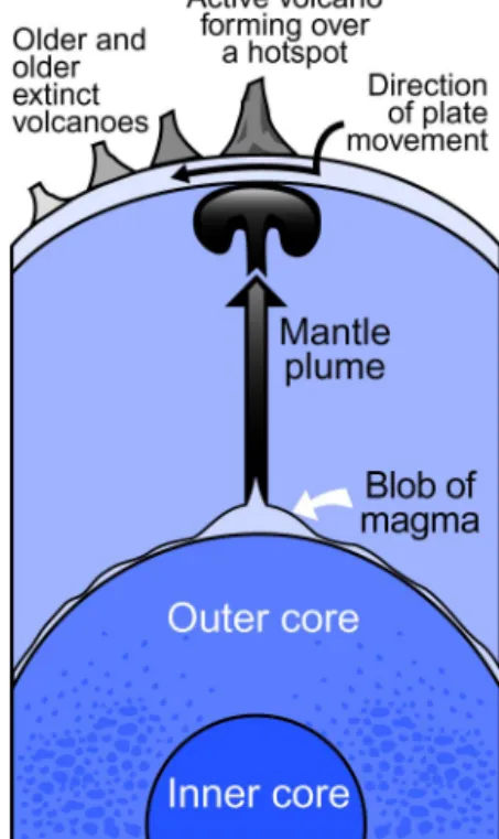
Shield volcanoes are made of fast-flowing, basaltic lava. Although these volcanoes can become very large, their overall shape is flattened because the lava flows too quickly to accumulate on top. Most of these volcanoes form over
hotspots. The eruptions of shield volcanoes are usually mild because the lava has low viscosity. However, if water enters the main vent, an explosive eruption may occur.
How shield volcanoes form
Scientists believe that heat from the outer core warms the lower mantle. At certain places, a blob of magma forms at the boundary between the outer core and the mantle. When the blob gets big enough, it rises toward Earth’s surface as a mantle plume and becomes a hotspot (Figure 29.4). Hotspots originate under the lithosphere so they are nearly stationary or move at rates slower than overriding plates.
Hawaiian Islands As an oceanic plate moves over a hotspot (over millions of years), a series of volcanoes form. The Hawaiian Islands were formed in this way. The oldest of the islands is Kaui; the biggest, Hawaii (called the Big Island), is still being formed. Hawaii alone has five shield volcanoes on it, three of them are “world record holders.” Mauna Kea is the highest mountain (10.3 kilometers, measured from the seafloor; Mount Everest is 8.84 kilometers above sea level), Mauna Loa is the largest mountain by volume, and Kilauea is the most active volcano.
Figure 29.4: How a hotspot forms.
Hotspot volcanoes
556
Stratovolcanoes (Composite volcanoes)
The Ring of Fire and subduction
The majority of the world’s volcanoes are stratovolcanoes. Unfortunately, these tend to be the most explosive and destructive kind. In particular, these volcanoes are found within the Ring of Fire, which is associated with subduction zones. At some of the edges of the Pacific Ocean, thinner, denser, oceanic plates are sliding under continental plates. Stratovolcanoes are formed at these locations.
How stratovolcanoes form
When the subducting oceanic plate encounters hot mantle, water is released. This water reduces the melting point of the surrounding rock so that it melts at a lower temperature. Because the magma is less dense than the surrounding solid rock, it rises to Earth’s surface. As the magma passes through the overlying continental and oceanic crust, it dissolves continental rock which is high in silica and becomes very viscous.
Eruption of stratovolcanoes
Eventually, a significant amount of this thick magma collects in a magma chamber. As the magma rises and begins to cool, gases are released and create excess pressure in the magma chamber. This pressure is relieved when cracks occur in the overlying crust and creating passageways to the surface. If a lot of gases are present, then the result is an explosive eruption. The intensity of the eruption is amplified by the conversion of water to steam. Additionally, as magma rises to the surface, gas bubbles become larger. These expanding bubbles contribute to the intensity of the volcanic explosion.
Examples of stratovolcanoes
The Cascade Range near the west coast of the United States includes Mount St. Helens among its stratovolcanoes. They are also found in Indonesia and along the west coast of South America in the Andes Mountains of Chile.
Nuée ardentes
557
29.1 Volcanoes
Cinder cones
More about cinder cones
Cinder cones are common, relatively small volcanoes. They can form over a vent in clusters or on the side of a larger volcano. Usually, cinder cones erupt only once. The length of those eruptions, however, can be from about a month to 10 years.
How cinder cones form
When water mixes with lava, it can cause an explosive volcanic eruption. The same is true if lava has in it a lot of dissolved gases. When a lot of gas and water are mixed into lava, pieces of the lava are blasted out from a vent and solidify in the air. These pyroclasts, called cinders, have numerous air pockets. As the cinders settle back onto the ground, they form the cinder cone. A cinder cone is a loose, cylindrical pile of this pyroclastic material with round crater at the top. Lava from a cinder cone tends to flow out of the base rather than at the top because the cone is made of loose material.
Parícutin, Mexico cinder cone
In 1943, a cinder cone volcano was born in a cornfield in Parícutin, Mexico. It began when gas-filled lava erupted from the ground. In a very short time, there was a pile of volcanic material. In the end, Mount Parícutin was a 400-meter high, steep-sided hill of ash and volcanic debris. It was active from 1943 to 1952.
Wizard Island cinder cone
Another well-known example of a cinder cone is Wizard Island in Crater Lake National Park in Oregon. This cinder cone formed in a caldera called Crater Lake (see the sidebar at right). This huge depression formed when the summit of Mount Mazama collapsed following a huge explosive eruption about 7,000 years ago. Mount Mazama was a stratovolcano. Its eruption was about 40 times greater than that of Mount St. Helens. After this eruption and the formation of Wizard Island, trillions of gallons of water from melted snow and rain filled Crater Lake. This lake, at about 2000 feet, is one of the deepest lakes in the world.
Exploiting cinder cones
Interestingly, cinder cone volcanoes are threatened by the fact that people like to take the materials that make up the cinder cone and use the materials for building roads and for sanding roads in the winter. Cinder cone rock is also used as decorative “lava rocks” for landscaping.
Figure 29.5: Wizard Island in Crater Lake.
Calderas
558
Additional sites of volcanic activity
Volcanic activity at ridges
Most volcanic activity on Earth occurs at mid-ocean ridges where plates are diverging. These regions are like long volcanoes. The Mid-Atlantic Ridge and the East African Rift Valley are slow-spreading ridges. Therefore, these ridges tend to have a valley where the plates are diverging. Volcanoes that form in these valleys are called rift volcanoes. An example is Mount Kilimanjaro in Tanzania, East Africa. The East Pacific Rise is a fast-spreading ridge and lacks a valley between the diverging plates. At both the Mid-Atlantic Ridge and the East Pacific Rise, lava forms new seafloor. An above sea-level version of volcanic activity is Iceland, a large island that is part of the Mid-Atlantic Ridge. Near Iceland, a volcanic eruption that started on the ocean floor formed a new island, Surtsey, in 1963 (Figure 29.6). This island experienced volcanic activity until 1967.
Island arc volcanoes occur at subduction zones
You have learned that volcanic activity is associated with subduction that occurs when an oceanic plate slides under a continental plate. Volcanoes also form when an oceanic plate slides under another oceanic plate. As the denser oceanic plate is pulled downward and melted in the mantle, magma rises and enters cracks in the non-subducting oceanic plate. The result is the formation of an arc of volcanic islands along the trench at the place where the plates converge. Examples of island arcs are the Caribbean Islands and the islands of Japan.
Figure 29.6: The birth of a new island. Surtsey was “born” near Iceland because of a volcanic eruption from the ocean floor.
Volcanoes shape Earth
559
29.1 Volcanoes Hydrothermal
vents
Hydrothermal vents are deep sea chimney-like structures that occur along mid-ocean ridges. Seawater that has been heated by magma to high temperatures comes out of the vents. When this hot, mineral-rich water reaches the cold water (about 0°C) at the sea floor, the dissolved materials precipitate and form the chimneys. Sulfur is an important mineral associated with these vents. Living near the vents are giant tube worms that live off bacteria that use hydrogen sulfur to make food. These bacteria use chemosynthesis, a process like photosynthesis, to survive. Instead of using the sun’s energy to make food and oxygen from carbon dioxide and water, they get their energy from the reaction between oxygen and hydrogen sulfide (H2S). Interestingly, the source of oxygen for chemosynthesis is oxygen from photosynthesis at Earth's surface that has dissolved in the ocean water and circulated down to the deep ocean.
Volcanoes and the atmosphere
When volcanoes erupt, large amounts of gases and particulates are released into the atmosphere causing natural air pollution. The gases include sulfur dioxide and nitrogen oxides. The dust released by volcanoes may be responsible for temporary cooling of Earth’s climate. Additionally, water vapor from volcanoes has been an important source of water for Earth's surface and atmosphere.
Special names for lava
Because of the volcanic nature of the Hawaiian Islands, some
volcanic terms are Hawaiian names.
Two of these are pahoehoe
(pah HOH ee hoh ee) and
aa (Ah ah). These terms
560
Products of volcanic activity
Geysers and hot springs
Geothermal energy can heat water underground and generate steam. When this steam is released naturally, it is called a geyser. In Yellowstone National Park, Old Faithful is a very famous geyser that releases water and steam every 33 to 93 minutes. The geyser occurs when pressure builds up underground and forces a blast of steam and water. Hot springs are pools of groundwater that have been heated by pockets of magma. This heated water collects at Earth’s surface. In the mountainous regions of Japan, a cold-weather monkey called the Japanese Macaque keeps warm by sitting in hot springs.
Mineral deposits and diamonds
Water heated by volcanic activity has dissolved minerals in it. As this water cools, the minerals precipitate, forming rich deposits of economically important minerals such as gold, copper, zinc, and iron. Some gemstones are also associated with volcanic activity. For example, diamonds form at high temperatures deep underground when carbon crystallizes inside rocks called kimberlites. Kimberlites reached the surface during violent eruptions of ancient volcanoes. Scientists believe that this magma, which was highly pressurized, moved toward Earth’s surface at twice the speed of sound. At the surface, the kimberlites cooled and hardened in volcanic vents and cracks in the crust, becoming today’s diamond resources. Diamonds are mined on every continent except Europe and Antarctica where they may exist but remain undiscovered. Regions that are rich in kimberlites include Australia, Russia, and, in Africa, Botswana, the Democratic Republic of Congo (formerly Zaire), and South Africa. In the United States, there are diamond mines on the Colorado-Wyoming border and in North Carolina. The latest discovery of diamonds resources has been in Canada.
.
Geothermal energy
Some places on Earth do not rely on fossil fuels to have heat
or heated water. This is because they are able to utilize heat and steam that is trapped in Earth’s crust. This kind of energy is called
geothermal energy. Places that use geothermal energy include Iceland, New Zealand, and Northern California.
561
29.1 Volcanoes
Describing volcanoes
Assessing the status of a volcano
The scientists who study volcanoes are called volcanologists. In addition to trying to predict the timing of a volcanic eruption, they determine how hazardous an eruption might be. Volcanologists spend their time observing and describing volcanic regions. An active volcano may soon erupt or has just erupted. Presently, there are about 500 active volcanoes on Earth, causing an average of 60 eruptions per year. A dormant volcano does not show signs of erupting, but it may erupt in the future. The time until the next eruption may not be for hundreds or thousands of years. Dormant volcanoes include Campi Flegrei caldera in Italy, Mount Baker and Mount Hood on the West Coast of the United States, and Nisyros, a stratovolcanic island that is part of Greece. An extinct volcano is one that has ceased activity. Examples of extinct volcanoes are Mount Kilimanjaro in Tanzania, East Africa; Mount Warning in Australia; 90 volcanoes in the volcanic region of France called Chaine des Puys; and Mount Elbrus in Russia, Europe’s tallest mountain at over 5.4 kilometers.
Describing volcanic rock
Volcanic activity results in the formation of two kinds of rocks—
extrusive and intrusive igneous rocks. Rocks formed from lava, which has been erupted on the surface, are referred to as extrusive. These rocks cool quickly and have fine crystals as a result. Extrusive rocks are associated with volcanic eruptions. When magma cools and solidifies below Earth’s surface, intrusive igneous rocks are formed. Because these rocks cool more slowly, they have larger crystals. A batholith is a large underground rock that formed when a mass of magma cooled underground.
Can volcanoes be predicted?
It is easier to predict a volcanic eruption than an earthquake because there are many more signs that a volcano might erupt. Predictors of eruptions include:
• Earthquake tremors that result from magma collecting in the ground. • Heating of water near the
volcano.
• The release of gases from the volcano.
• Surface changes of the volcano.
562
Figure 29.7: The craters on the surface of the moon are the result of impact craters from meteorites. How does the surface of Earth compare with that of the moon?
Figure 29.8: The formation of the Alps is still occurring as the African and Eurasian plates converge.
29.2 The Surface of Earth
A full moon in the night sky gives you a glimpse of what the moon looks like. Unlike Earth, the moon has no plate tectonic activity. Additionally, the moon is nearly free of water and lacks an atmosphere. Without plate tectonics and erosion by wind and water, the surface of the moon has stayed the same for a very long time (Figure 29.7). In comparison, Earth’s surface is always changing. In this section, you will learn about forces that cause these changes.
Earth’s lithosphere
Earth’s surface is constantly changing
Earth’s lithosphere is very thin compared with the whole planet. Pieces of the lithosphere, called tectonic plates, move on Earth’s surface. Recall that earthquakes, volcanoes, mountains, and the construction of new lithosphere are events that occur at plate boundaries. These events are changing the appearance of Earth’s surface all the time. For example, the slow collision of tectonic plates continues to build mountains. Mountains that are still being built include the Rockies, Himalayas, and Alps (Figure 29.8). Somewhere on Earth, an active volcano is erupting and adding more lava to Earth’s surface.
Constructive vs. destructive processes
The features we see on Earth’s surface represent the dynamic balance between the
563
29.2 The Surface of Earth
Mountain-building, a constructive process
How mountains form
Mountain-building is a major constructive process. Mountains form in three main ways: by folding at convergent plate boundaries; by movement of chunks of land at faults; and by volcanic activity.
Fold mountains Scientists explain how fold mountains formed using the theory of plate tectonics (Figure 29.9). The Andes were formed as the Nazca plate subducted under the South American plate. At this convergent boundary between a subducting oceanic plate and a continental plate, mountains formed along the west coast of South America due to folding and faulting (breaking into chunks due to the lithosphere cracking under pressure). Mountains also form when two continental plates collide. For example, the Himalayas are fold mountains that began to form more than 40 million years ago when the Indian and Eurasian plate collided.
Fault-block mountains
Sometimes pressure at plate boundaries causes the lithosphere to crack and become a fault. A result of this cracking is a fault-block mountain (Figure 29.10). When cracks occur, pieces of the lithosphere tilt or move. Chunks of rock that slide down create a valley. The chunks that move upward or tilt form mountains. Mountains near the San Andreas fault are examples of fault-block mountains.
Mountains formed by volcanic activity
Volcanic mountains occur at subduction zones (e.g., the Ring of Fire) and at hotspots (Figure 29.11). A volcano is formed by the extensive layering of lava and volcanic material that builds up over millions of years with each eruption. For this reason, these mountains often stand alone; they are not part of a mountain range. A
dome mountain is formed by a bulge of magma forcing the lithosphere upward.
Formation of the Andes Mountains
In the 1830s, Charles Darwin found seashell fossils in the Andes on the west coast of South America. Darwin’s interpretation of his findings was that a powerful, slow-moving force from Earth had thrust the bottom of the sea upward and formed the Andes. The Andes are so high that even if the polar ice caps melted, there would not be enough water on Earth to completely cover these mountains. This means the Andes could not have been undersea mountains at one time.
Figure 29.9: Examples of fold mountains include the Andes and the Himalayan Mountains.
Figure 29.10: Mountains along the San Andreas fault are examples of fault-block mountains.
564
Erosion, a destructive process
What is erosion? Erosion (also known as weathering) is a major destructive process. This term describes the continuous physical and chemical events that cause land and rock to wear down. To understand erosion, think of a sand castle. Once you have made your sand castle, it does not take long for water, wind, and people to transform your castle back to a pile of sand. Likewise, mountains are made of rock and soil. They are eroded by wind and water in the form of rain, streams, and ice in the form of glaciers. Mountains grow or get higher when they form faster than erosion occurs. However, when the mountain forming process slows down, erosion dominates. The rate of erosion is related to the height and steepness of the mountain—the steeper the mountain is, the faster it erodes because it is easier to push material down a steep slope than a gradual slope. Mountain building is a slow geologic process taking millions of years. Mountain weathering is rapid by comparison.
Young versus old mountains
You can tell if a mountain is young or old by the shape of the peaks. Sharp mountain peaks indicate a young mountain. Although the Himalayas began forming more then 40 million years ago, the sharp peaks indicate that these mountains are relatively young. Rounded mountain peaks indicate an old mountain that has worn away for a long time. The Scottish Highlands are old, rounded mountains that are about 250 million years old. The Appalachians, also old rounded mountains, are more than 200 million years old.
Landforms shaped by water
Valleys are good examples of the power of water and gravity on land. Rain falls and flows down steep-sided mountains, eventually collecting in a large body of water like a lake or ocean. At the top of a mountain, water runs quickly and carves V-shaped riverbeds. Over time, the river carves out enough room to move side to side and make the valley U-shaped. Valleys can also become U-shaped when a glacier moves through a river valley like a giant ice cream scoop. Near the ocean (or any slower body of water like a lake or pond), a river may spread out and form a delta. A delta is a place where a river spreads into a fan shape as it slows down and deposits large amounts of sediment. The Mississippi Delta is a well-known delta in the United States. Another well-known feature that was shaped by a river is the Grand Canyon, created as the Colorado River ran through it.
565
29.2 The Surface of Earth
Formation of soil
What is soil? The formation of soil is the result of erosion. Soil is made of weathered rock and decayed animals and plants. For this reason, it is rich in nutrients and a suitable medium in which plants can anchor their roots and grow. Important compounds and elements would remain trapped in rocks and unavailable to plants in the soil if it was not for erosion. Ultimately, through the food chain, the nutrients are passed on to us.
The characteristics of soil
The characteristics of soil depend upon the type of rock that is weathered. The main sources of soil are volcanic and mountain rocks. The characteristics of soil also depend on the type of weathering. Chemical weathering mostly occurs in hot, wet climates such as tropical rain forests. Examples of chemical weathering are rust formation in iron-containing minerals and erosion by rain which is always a little acidic. Some soil characteristics depend on temperature because some reactions that cause chemical weathering occur faster at warmer temperatures.
Mechanical weathering mostly occurs in cold, dry climates such as tundras in polar regions and involves breaking up rock into smaller and smaller pieces.
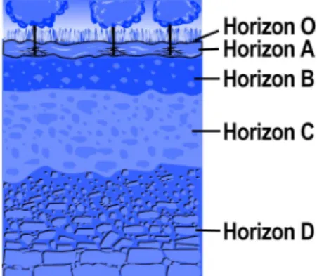
A soil profile Figure 29.13 illustrates a soil profile. A soil profile is a cross-section that shows the different layers of soil in the ground. It takes a long time and a lot of weathering for soil to have all the layers you see in this figure. Young soil does not have each of these layers.
• Horizon O: A very thin layer composed of humus, an organic, nutrient-rich soil made from the decay and waste products of plants and animals.
• Horizon A: A dark layer called topsoil that is composed of more humus and small pieces of rock. It is home to many animals. For example, about 1 billion small and microscopic animals live in one cubic meter of topsoil.
• Horizon B: A layer of clay and small rocks where dissolved minerals collect. The color of this layer depends on the rock and mineral types in the layer. • Horizon C: A layer of weathered rock pieces and minerals.
• Horizon D: Solid rock called bedrock formed in place over time. This layer is covered by the layers of soil.
Figure 29.13: A soil profile.
Wind erosion
566
Glaciers
What is a glacier? Glaciers at the poles are a frozen form of about 2 percent of all the water on Earth. Additionally, about 10 percent of Earth’s surface is covered with glaciers. A
glacier is a huge mass of ice that can be many kilometers thick and thousands of kilometers wide. Glaciers are formed from the accumulation of snow over hundreds or thousands of years. Each year more snow is piled up and does not melt during the warmer summer months. As the snow piles up and pressure increases, it changes into ice. This effect also occurs when you pack snow into a tight snowball. With the buildup of ice, a glacier becomes so thick and heavy that it flows (Figure 29.14). The force that drives this movement is gravity. Near the oceans, pieces of glaciers may break off, float away, and become icebergs.
Ice ages An ice age is a period of tens to hundreds of millions of years when the climate of Earth is very cold. During this time, much of the surface is covered with glaciers that repeatedly moved forward and backward from the poles to the equator. There have been four ice ages during Earth’s history. Within each ice age, there have been shorter periods of time of thousands of years when the glacial coverage was at its maximum size. These shorter periods of time are called glaciations. In our present time, we are experiencing the fourth and most recent ice age that began about 1.5 million years ago. During this time, there have been several glaciations. Presently, we are in a “warm” period between glaciations. This present warm period began about 10,000 years ago.
The effect of glaciers on land
About 30 percent of Earth’s surface (much of North America and Europe) was covered by glaciers 10,000 years ago. As Earth’s climate warmed, the glaciers melted and moved toward the poles and higher elevations, pushing around huge piles of rocks, scratching the surfaces of rocks, and eroding the mountain tops. For example, Long Island was created by a glacier bulldozing and depositing rocks during the last glaciation. The rocky soil of New England is evidence of the movement of glaciers. Scientists also believe that some earthquakes in North America are likely to be the result of the Earth slowly rebounding into place after having been pressed down by glaciers. If the glaciers on Earth continued to melt, sea level would rise about 76 meters and many big coastal cities would be flooded.
Figure 29.14: A glacier accumulates ice faster than the ice melts. The mass of ice becomes so thick and heavy that it flows.
What causes ice ages?
567
29.2 The Surface of Earth
Geologic hazard maps
What are geologic hazard maps?
Geological hazards are natural events that could result in loss of life and property damage. For this reason, it is very important for builders to consult geologic hazard maps before they begin construction of any building or home. Geologic hazard maps indicate the location of faults where earthquakes occur, areas where volcanoes are active, and where landslides, avalanches, floods, or other natural hazards are possible. These maps sometimes indicate the degree of likelihood that hazardous events will occur. They also indicate hazards that are associated with each other. For example, when strong earthquakes occur, water-saturated soil (usually composed of sand and silt) becomes very loose and acts like a viscous liquid. A similar action takes place when you stand in the surf on a beach and wiggle your feet. Your feet quickly sink and are buried by the water-saturated sand. During an earthquake, this effect, called liquefaction, results in homes, buildings, bridges, and cars sinking into the ground (Figure 29.15).
An example of a geologic hazard map
Geologic hazard maps show whether or not hazards occur in a particular region. In communities where geologic hazards are common, a geologic review of the property is required before construction of a building can begin. An example of a geologic hazard map is shown below. The map shows section 25 of a geographic region that has been divided into 32 sections.
Figure 29.15: Liquefaction occurs when soil is saturated with water. During an earthquake, increasing pressure on the soil increases the water pressure in the soil. This sometimes means that individual soil particles lose contact with each other. The result is that the soil acts like a viscous liquid.
Topography
568
Human impact on Earth’s surface
What is urban sprawl?
As the human population grows, we take up more space. Sometimes we take up more space than we need. The term urban sprawl refers to how living areas around a city “sprawl” as they grow instead of concentrate near facilities that serve the people of the community (Figure 29.16).
The environmental impact of urban sprawl
When urban sprawl occurs, it is more difficult to serve a community using publicly-funded transportation like buses, subways, and commuter rails. As a result, more roads are built and large traffic jams make travel more difficult. Building roads changes the land. Roads and parking lots prevent water from slowly seeping into the ground to replenish the water supply in aquifers. Instead, water quickly runs off the paved surfaces causing the increased flow rate of water in nearby rivers and streams. When water flows quickly, soil and plant life on the banks are washed away and the overall health of the river and stream is reduced.
Urban sprawl changes local climate
Another effect of urban sprawl has to do with what happens when trees are cleared to make room for buildings and roads. Rooftops and road surfaces give off a lot of heat such that a region becomes an “urban heat island.” When a city is hotter, there tends to be more ozone pollution which causes respiratory problems and inhibits photosynthesis in plants. Additionally, as heat rises and colder air flows into the gap left behind, an unusual number of thunder and lightening storms may occur. Although these storms can clean pollution out of the air, they also cause local flooding because there are fewer greenspaces to absorb water.
How can the effects of urban sprawl be reduced?
The first step in making a difference in reducing urban sprawl is to understand what is happening. Once you are aware of a problem, you can take steps to change some habits that create urban sprawl and the problems associated with it. To reduce the need for more roads and reduce air pollution from cars, you can walk, take public transportation, or drive more fuel-efficient cars. Another helpful habit is to maintain cars so that oil and fluids don’t leak on to paved surfaces and become pollutants in our water supply. Cities can curb the effects of urban heat islands by adding heat-reflective rooftops to buildings and by planting more trees in urban areas. Trees and plants are natural “air-conditioners” that keep areas cooler through shading and by absorbing heat.
Figure 29.16: Urban sprawl occurs when the growth of a
569
29.2 The Surface of Earth
Extraterrestrial shaping of Earth’s surface
The moon versus Earth
The surface of the moon is much different from the surface of Earth. Whereas Earth’s surface has been in constant change, the surface of the moon has been preserved. In the late 1960s and early 1970s, the Apollo space missions went to the moon. By studying very small pieces of the moon rocks brought back to Earth by these missions, scientists have learned that the moon’s surface is about 4 billion years old, nearly as old as the solar system. Because the moon’s surface is so well-preserved, it is our best research lab for studying what was happening in the solar system 4 billion years ago.
Showers of comets and asteroids on Earth and the moon
Scientists believe that 4.1 to 3.8 billion years ago, the surfaces of the moon and Earth experienced torrential showers of comets and asteroids. The many craters on the moon’s surface are evidence of these showers. By comparison, Earth has very few craters. This does not mean that Earth did not get hit by these comets and asteroids. Rather, the constant change of Earth’s surface due to plate tectonics
and weathering has hidden most of the evidence. There is evidence that Earth was hit in Arizona, at the famous impact crater called the Meteor Crater. This crater, whose diameter is 1.2 kilometers, was formed by an asteroid with a diameter of 24 meters.
Are there Earth rocks on the moon?
By studying the moon, scientists believe that in a 200-million-year period, Earth would have experienced impacts that would have created 17,000 continent-sized craters. With such huge impacts, scientists believe it may be possible to find pieces of rock from Earth on the moon; these pieces would had been thrown off Earth on to the moon when an impact occurred. This idea has scientists petitioning NASA to send astronauts back to the moon to bring back more moon rocks for study.
How do you study moon rocks?
Because of the comet and asteroid showers millions of years ago, some moon rocks were blasted off the moon onto Earth. Scientists have studied these to find out more about Earth’s early history.
When an impact occurred on the moon, the impact caused moon rock to melt and release argon gas. At the same time, the impact forced the rock off the moon. This moon rock landed on Earth about a million years later. As the rock traveled through space, radioactive decay in the rock released more argon gas, which became trapped in the rock.
570
Figure 29.17: Diamonds and graphite are made of carbon. Diamonds form within volcanic rock that explosively reaches Earth’s surface. Graphite is made of organic material that has experienced high temperatures and pressures.
Figure 29.18: Some common minerals and their uses.
Some common minerals Name
(chemical
formula) Uses
silver (Ag)
jewelry, electrical wire, coins
corundum (Al2O3)
sandpaper, gems (e.g., rubies, sapphires)
quartz (SiO2)
glass making, gems (e.g., onyx, amethyst)
gypsum (CaSO42H2O)
used to make Plaster of Paris
29.3 Rocks and Minerals
When you pick up a rock, you hold a lot of history in your hands. This is because any rock is the result of numerous intense processes that have created it over millions of years. Such processes include the eruption of a volcano, erosion of land by a river, and mountain-building. Each of these processes listed is important in forming one of the three categories of rocks. In this section, you will learn how rocks are classified and formed. Using this knowledge, you will be able to tell the history of a rock.
Rocks are made of minerals
What is a mineral? The history of a rock begins with minerals because they are the building blocks of a rock. A mineral is a solid, naturally-occurring object with a defined chemical composition. Minerals are inorganic (meaning they do not result from living things) and have a crystalline structure. Usually, a mineral is a compound of two or more elements, but it can be made of a single element. For example, metals like copper and gold are minerals that occur as pure elements. It is important to note that different minerals can have the same chemical composition but have different crystal structure. For example, graphite and diamonds are two different minerals that are made of pure carbon (Figure 29.17). A list of some common minerals and their uses is provided in the table in Figure 29.18.
About 20 minerals make up Earth’s crust
571
29.3 Rocks and Minerals
Common minerals
What is feldspar? The feldspar in granite is usually white or pink. However, feldspar can also be green or other colors. Feldspar is composed of sodium, calcium, potassium, and silica. Feldspar has cleavage planes. A cleavage plane is a region where a rock cleanly splits. The placement of a cleavage plane occurs where there are weak bonds between atoms and molecules in the mineral. Many cleavage planes in the same direction appear as parallel lines (Figure 29.19).
What is quartz? Quartz crystals are dark gray, white, clear or rosy, and appear to glisten as if they are wet or oily. Unlike feldspar, quartz lacks cleavage planes. When quartz breaks, it does not split along planes. Quartz is made of silicon dioxide (SiO2) and is used in making glass. Gemstones like onyx, agate, and amethyst are made of quartz.
What is mica? Mica is a silicate (SixOy, where x and y represent different numbers of atoms) with various ions of iron, magnesium, and sodium. A piece of mica is like a small stack of paper sheets. A stack of paper sheets and a piece of mica are described as having a single cleavage plane (Figure 29.19). The two main types of mica in granite are white mica (called muscovite) and black mica (called biotite).
What is hornblende?
Hornblende is also found in granite. It is a dark mineral made of a mixture of elements including calcium and silicon, along with iron, magnesium, or aluminum.
More information about minerals
A mineral is a material that is naturally occurring, inorganic, and crystalline. Using this definition, ice is a mineral, but liquid water is not (Figure 29.20). Do you see why? On the other hand, coal is not a mineral because it is made from living things and is not a crystal (Figure 29.20). Most minerals (except metals) also have one or more cleavage planes that also help in determining their identity.
Recognizing minerals helps identify rocks
Recognizing common minerals is an important step to being able to identify a rock and understand how it formed. The majority of continents are made of granite and the most common mineral in Earth’s crust is feldspar. Quartz is the second most common mineral. Since granite is a common rock, it is useful to know how to identify mica and hornblende.
Figure 29.19: Mica has one cleavage plane. The mineral halite has three cleavage planes and breaks into cubes. Halite is made of sodium chloride. Next time you use table salt (also sodium chloride), look at the tiny grains. Each is a miniature cube.
572
Figure 29.21: The Mohs hardness scale is used to help identify minerals.
Mohs hardness scale Mineral Hardness
talc 1
gypsum 2 calcite 3 fluorite 4 apatite 5 orthoclase 6 quartz 7 topaz 8 corundum 9 diamond 10
Where to go to find out more about rocks
A rock key can help identify a rock by asking a series of questions. Keys also have diagrams or photographs to help you identify rocks. You can find a rock key at your local library. You can also learn about local rocks by contacting your state’s geological survey.
Identifying minerals
Mohs hardness scale
Mohs hardness scale was developed in 1812 by Friedrick Mohs (an Austrian mineral expert) as a method to identify minerals (Figure 28.2). This scale uses 10 common minerals to represent variations in hardness. You can identify a mineral’s place on the hardness scale by whether it can scratch another mineral. For example, gypsum (hardness = 2) scratches talc (hardness = 1). The hardest mineral, a diamond, can scratch all other minerals. Minerals of the same hardness (and without impurities) scratch each other.
Common items test the hardness of a mineral
In addition to the minerals listed in Figure 29.21, you can use common items. For example, your fingernail, a penny, and glass can be used to test the hardness of a mineral. The following scenarios illustrate how to use Mohs hardness scale. • A fingernail scratches gypsum, but gypsum does not scratch the fingernail.
The fingernail is scratched by calcite. What is the hardness of a fingernail?
Answer: 2.5
• A penny is scratched by fluorite, but the penny cannot scratch fluorite. The penny scratches calcite and calcite scratches the penny. What is a penny’s hardness? Answer: 3
• A piece of glass scratches and is scratched by orthoclase (a type of feldspar). The glass scratches apatite. What is the hardness of glass? Answer: 6
Identifying rocks
What is a rock? A rock is a naturally formed solid usually made of one or more minerals. Therefore, being able to recognize common minerals is very useful for identifying a rock. It is important to note that it can be difficult to identify a rock. Scientists sometimes have to rely on special microscopes to be sure about a rock’s identity.
Use your powers of observation to identify a rock
Your powers of observation are your best tools for identifying a rock. Ask yourself: What does the rock look like? Where was it found? Your answers to these questions may help you determine if the rock is igneous, sedimentary, or
573
29.3 Rocks and Minerals
What are igneous, sedimentary, and metamorphic rocks?
Igneous rocks
(ignis means “fire”)
Igneous rocks are made of magma or lava, the fiery hot material that originates in Earth’s mantle. Intrusive igneous rocks are formed from magma that has cooled and solidified below Earth’s surface. Deep underground, the temperature is very warm. Therefore, cooling and solidification of rocks takes a long time and large, visible crystals form as a result in intrusive rocks. Intrusive rocks tend to be coarse-grained. Granite is a common intrusive rock. The continents are mostly made of granite. Extrusive igneous rocks form from lava, molten material extruded onto Earth’s surface. At Earth’s surface, cooling and solidification of lava takes place relatively quickly so that very small crystals form. Extrusive rocks tend to be fine-grained. Basalt is a common extrusive rock with very small crystals. The ocean floor is made of basalt.
Sedimentary rocks (sedimentation
means settling)
Sedimentary rocks are made of the products of weathering. Wind or water
weathers existing rocks in a process called erosion. Then, wind and water deposit the eroded particles (called sediment) in layers. Mineral water flows between the particles in the layers as they compact. As water is forced out by temperature and pressure, the particles are cemented. Over millions of years, compaction and cementing turn layers of sediment into rock. The most important kinds of sedimentary rocks are clastic, organic, and chemical. Clastic rocks result from eroded bits of rocks being pressed together. Organic rocks, like coal, form when
layers of decaying sediments of once living animals and plants are compacted. Over millions of years, a 20-meter layer of decaying plant material will turn into a one-meter layer of coal. Chemical rocks are formed when a solution of dissolved minerals evaporates leaving behind a rock with many mineral crystals. Rock salt (called halite) and gypsum are examples of chemical rocks.
Metamorphic rocks (metamorphic
refers to a change of form)
A metamorphic rock is an igneous, sedimentary, or other metamorphic rock that has been transformed by pressure or frictional heat from deep burial under layers of rock or from the compression that occurs during mountain-building. Rocks that experience this intense pressure and heat are said to be metamorphosed. For example, numerous metamorphic rocks formed when India and Asia collided to form the Himalayan Mountains. Metamorphic rocks are often exposed at Earth’s surface when layers of sediment above these rocks are eroded.
Figure 29.22: Rocks are useful materials for creating structures that last. Mount Rushmore is a famously sculpted mountain of granite, an igneous rock. The United States’ White House is made of sandstone, a sedimentary rock. Slate, a
574
Identifying a rock
What does the rock look like?
When examining a rock, it is helpful to break it open to see the interior. The outside of a rock can be misleading due to color changes that occur with weathering. Next, it is important to look at the grain of a rock’s texture. Grain refers to the fact that a single rock is made of other rock pieces or mineral crystals of various sizes and shapes and in different patterns. Rocks that are coarse-grained have large particles and the minerals that make up this kind of rock are visible. Rocks that are fine-grained have very small particles that can only be interpreted with a magnifying glass or microscope. Grains can appear as specks, crystals, or as round or angular pieces. The particles and grains in a rock can be randomly placed or organized into straight or wavy layers.
What is the composition of a rock?
Using your eyes is the first step to identifying a rock. For example, in some cases the composition of a rock can be determined by looking at its mineral crystals. With practice, you will be able to identify common minerals in rocks. To aid you in identification, you can use a magnifying glass. Often to identify crystals, geologists make thin slices of a rock for viewing under a microscope or a
microprobe. A microprobe is used to melt a specific crystal in order to identify its chemical composition and properties. Other techniques for identifying minerals include making a streak of the mineral on a ceramic tile. The color of the streak is not always the same as the color of the mineral. For example, silvery hematite used for jewelry will leave a reddish streak. The color of the streak gives you a clue about the identity of the mineral. As you learned earlier, you can identify the relative hardness of the mineral using Mohs hardness test. Also, the smell of the rock can be helpful in identifying if a rock contains sulphur compounds. Finally, an acid test will help you identify whether or not a rock contains calcium carbonate because this substance reacts with acid. How would you determine whether or not a rock contains magnetic metals like iron or nickel? Such a rock would attract a magnet.
What is a geode?
575
29.3 Rocks and Minerals
Identifying igneous, sedimentary, or metamorphic rocks
How do you tell if a rock is igneous?
Igneous rocks can often be identified by their texture. For example, igneous rocks have crystals that intersect at angles. However, the grain in these rocks usually does not have a pattern or a uniform orientation of crystals. The size of the grains depends on how fast the rock cooled during its formation. Some igneous rocks are glassy (very fine-grained) because they cooled quickly. Basalt is a fine-grained rock. An example of a slow-cooling igneous rock with large, easy-to-see grains, is granite. Granitic rocks are easy to find in mountainous regions where they have been exposed due to weathering. In flatter regions, this intrusive igneous rock is often buried by sediments. Mount Rushmore in South Dakota is made of granite.
How do you tell if a rock is sedimentary?
Sedimentary rocks often appear to have layers of rock pieces. Because the pieces tend to sort by size, a sedimentary rock tends to have same sized pieces or the same sized particles are organized into layers. The boundaries between pieces in a sedimentary rock are not well-defined. Sedimentary rocks are often found in areas where sediment gets deposited. Sedimentary rocks with large pieces tend to form in high-energy environments, like the bed of a fast-moving river (conglomerate rock). Sedimentary rocks with small pieces form in low energy environments like a pond, lake, or the ocean floor (shale). Sedimentary rocks are common and easily seen in the mid- and southwestern United States. For example, the Grand Canyon is a giant land formation made of layers of sedimentary rock that have been exposed by weathering.
How do you tell if a rock is metamorphic?
The grains in metamorphic rocks tend to orient themselves based on how the rock was metamorphosed. Rocks that are modified by pressure have grains oriented in lines. An example of this kind of metamorphic rock is slate formed from shale (a sedimentary rock). Rocks that are modified by pressure and heat have grains oriented in foliations (wavy patterns). These rocks appear layered or foliated. Examples of foliated rocks are gneiss formed from granite. Examples of nonfoliated rock include some forms of marble formed from limestone. Metamorphic rocks tend to be the hardest and most weather-resistant rock of the three kinds. These rocks are often associated with mountains because the pressures that arise from mountain-building cause the formation of these rocks.
The history of a rock
Marble is a weather-resistant, crystalline rock often used by sculptors. How is marble formed?
576
The rock cycle
What is the rock cycle?
The rock cycle illustrates the formation and recycling of rocks by geological processes. Let’s begin with a piece of granite that is part of a mountain. This granite is weathered by wind and rain. Sediments from the eroded rock are washed down the mountain where they enter a stream and then a river that empties into the ocean. These sediments are deposited on the ocean floor where they will be covered by other sediments. Eventually, these layers of sediments are compressed and cemented to form a sedimentary rock. As a sedimentary rock becomes buried deeper and deeper by more and more sediment, it experiences intense pressure and becomes a metamorphic rock. Next, this metamorphic rock is pulled down into the mantle at a subduction zone. Now the metamorphic rock melts and becomes magma. Then, the magma rises toward Earth’s surface to become a intrusive igneous rock like granite or an extrusive rock like basalt. The magma could also be ejected from a volcano as lava and then cooled to become an extrusive igneous rock like pumice. Either way, the rock cycle continues as another igneous rock weathers to become a sedimentary rock, melts to again become igneous, or metamorphoses into another metamorphic rock.
Key processes in the rock cycle
The rock cycle illustrates how matter is recycled. The processes that keep rock material moving through the rock cycle are weathering,
compaction and cementing,
577
Chapter 29 Review
Vocabulary review
Match the following terms with the correct definition. There is one extra definition in the list that will not match any of the terms.
Set One Set Two
1. magma a. The pattern of volcanoes and earthquakes that occurs at the boundaries of the Pacific Ocean
1. geothermal energy a. A wide and long depression that occurs where two tectonic plates are diverging
2. lava b. A glowing cloud of hot volcanic material 2. stratovolcano b. An opening on the ocean floor that allows high heat and gases to escape from the mantle 3. Ring of Fire c. A place where magma collects underground 3. shield volcano c. A type of volcano that results from a hot spot 4. magma chamber d. A bowl-shaped depression at the top of a volcano;
also, a large depression that results from an extraterrestrial object hitting land
4. hydrothermal vent d. A violent type of volcano that is related to a buildup of pressure and viscous magma. Many of these volcanoes occur at subduction zones. 5. crater e. Molten material from the mantle that reaches
Earth’s surface
5. rift valley e. Energy that is generated from heat and steam in Earth’s crust
f. Molten material that originates in the mantle f. Energy that is generated from water
Set Three Set Four
1. cleavage plane a. A reduction in greensapce and increased traffic are results of this phenomenon
1. metamorphic rocks a. Rocks that are produced when magma or lava cools and solidifies
2. urban sprawl b. The break down of soil, rocks, and land formations due to climate and seasonal changes
2. igneous rocks b. Rocks that are produced when layers of rock pieces are compacted to form a new rock 3. erosion c. A cross-section of ground that shows the layers of
sediment
3. sedimentary rocks c. Examples include quartz and mica
4. soil profile d. A term used to describe the shape of land and the
presence of bodies of water and mountains 4. rockcycle
d. Examples include marble, slate, and granite
5. topography e. A region in a mineral where it will split cleanly due to weak interactions between molecules
5. mineral e. The set of processes that lead to the formation and recycling of the various kinds of rocks f. The way that crystals are arranged in an igneous
rock
578
Concept review
1. Explain the difference between magma and lava.
2. Imagine you are a blob of magma coming up through the Mid-Atlantic Ridge. Describe what might happen to you on your next step in the rock cycle.
3. Write a paragraph that explains how tectonic plates are involved in causing earthquakes and volcanoes.
4. Is erosion a constructive or a destructive force that shapes the land? Explain your answer.
5. When sugar water crystallizes, rock candy is made. Would you describe large crystals of rock candy as a mineral, a rock, or neither? Justify your answer.
6. Compare and contrast the main types of rocks: sedimentary, igneous, and metamorphic. Give an example of each type. 7. List three ways the rock cycle is like the water cycle, and three
ways in which these two cycles are not alike.
8. The crust of Earth is mostly which kind of rock—igneous, sedimentary, or metamorphic? Explain your answer.
Problems
1. A volcanologist finds that the silica content of the volcanic rock near an ancient volcano is 48 percent. From this information, describe the probable type of volcano and its eruption. Where might this volcano be located?
2. Glaciers covered much of North America 30,000 years ago. The average rate at which glaciers move is two meters per day. Assuming this rate is constant, how far would a glacier move in 15,000 years?
3. You are given the task of organizing a collection of minerals used to represent the variations of hardness. Seven of nine minerals have labels. You know that the collection does not contain a diamond. Use the Mohs hardness scale and the information below to identify the two unlabeled minerals. a. The first mineral scratches talc and gypsum. This mineral
does not scratch fluorite. What is this mineral?
b. The second mineral scratches topaz and quartz. You guess that a diamond would scratch this mineral. What is it?
Mohs hardness scale Mineral Hardness
talc 1
579
1. In Yosemite National Park there is a large granite formation called Half Dome. The distance from the bottom of the valley to the top of Half Dome is one kilometer. The top of Half Dome is rounded instead of peaked the way most mountains look. How do you think Half Dome formed? To develop a hypothesis, answer the following questions.
a. What kind of rock is granite? Is it intrusive or extrusive? b. Did Half Dome form as a result of a volcanic eruption? Did
it form as a result of two continents pushing against each other?
c. Why might Half Dome be rounded?
d. Develop a hypothesis about Half Dome: In your opinion, how did this rock formation form?
e. Now research the geology of Half Dome on the Internet or in your local library. How did it form? Compare your research findings with your hypothesis.
l
Applying your knowledge
1. Use what you have learned from this chapter and the previous chapter to come up with a plan for determining the age of an extinct stratovolcano. Write down your plan as a series of steps. 2. Magma and lava have different characteristics based on their silica content. In previous units, you learned about viscosity and
solutions. Review these terms and answer the following questions.
a. Which is more viscous, magma directly from the mantle or magma that contains dissolved rock from the continental crust? Explain your answer.
b. Are magma and lava solutions? Explain your answer. 3. Compare the effect of pressure on the change from solid rock to
magma to the effect of pressure on the phase change of water from a liquid to a gas.
4. Imagine that your community has an opportunity to build a geothermal power plant and your job is to market geothermal energy to your community. What would you say to convince your community to convert from their present source of energy to geothermal energy? Use your local library or the Internet to research the benefits of using geothermal energy and find out where geothermal energy is being used in the United States. Make a brochure that explains these benefits and answers questions that people might have.
580
6. Water and human beings play a role in shaping Earth’s surface. Which of these two things changes Earth’s surface more? Justify your answer.
7. The oldest rocks that we have observed so far on Earth are 4 billion years old. You know that the Earth is 4.6 billion years old. Based on what you have learned in chapters 28 and 29, come up with a hypothesis to explain why the oldest rocks on Earth are younger than the Earth itself. Explain and justify your hypothesis in a detailed paragraph.
8. Could the rock cycle occur if Earth did not experience plate tectonics? Given your answer, explain whether or not there is a rock cycle on the moon.
9. You have learned that the polarity of Earth’s magnetic field has switched over time. You also learned that the reversal of the magnetic field is recorded in rocks. If you were going to research this phenomenon, which kind of rock (igneous, sedimentary, metamorphic) would be best to study and why? In your answer, explain why the other kinds of rock would not be useful to study.
10. A geologic hazard map shows that a number of active volcanoes follow the western coastline of South America but there are no volcanoes on the eastern coastline.
a. Explain the pattern of volcanoes on the South American continent. Predict whether or not this pattern will change in the next 1 million years.
b. As far as you can tell, will there ever be volcanoes on the east coast of South America? Why or why not?