2 Overview
2.1 Name
INSPIRE data specification for the theme Statistical Units.
2.2 Informal description
Definition:Units for dissemination or use of statistical information. [Directive 2007/2/EC] Description:
A Statistical Unit (SU) is a spatial feature (Polygon, Line, Point or Grid cell) that can be used to attach statistical information. Statistical information can be defined as "any numerical representation of a phenomenon" like for example human population. It must concern information about a certain population not restricted to human population.
Statistical information is not considered as part of the statistical unit. It is a non-spatial thematic information, whose harmonisation is out of the scope of this document. For this information we refer to the specification of the INSPIRE theme Population Distribution. This document only focus on the representation of the spatial features used to attach any kind of statistical data.
All INSPIRE features can be seen as a statistical unit. For example, road traffic data can be attached to RoadLink features of the Road Transport Networks theme, and population data can be attached to
Building features of the Building theme. Statistical units theme addresses the units that are not already addressed by other themes and that are usually used only for dissemination of statistical data.
Important characteristics of statistical units are:
• They may have a hierarchical structure (like NUTS1, 2 and 3).
• Their spatial extent can go from sub-local (smaller than municipalities/communities) level to country level.
• Their temporal extent differs per country. They can change in time, which makes time comparisons difficult.
• In many cases they are derived from administrative units, but other sources are also possible. Existing statistical units
NUTS
Since many years European regional statistics have been collected, compiled and disseminated on the basis of a common regional classification, called ‘Nomenclature of territorial units for Statistics’ (NUTS). At the top of the hierarchy there are the individual Member States of the EU and below the NUTS levels 1 to 3. In general, one or two NUTS levels match with existing national administrative units. NUTS units are therefore an important type of statistical unit. Clear rules for this classification system have been fixed in a legal framework (Regulation (EC) No 1059/2003).
LAU and Urban Audit
The NUTS classification serves as a harmonised system for applications at European and regional level, while it does not preclude the existence of other subdivisions and classifications. At a more detailed level, there are the regional districts and municipalities used in European context. These are called Local Administrative Units (LAU) sometimes used in European legislation. Other examples of statistical units are the urban area's used in the Urban audit project, organized by Eurostat. Neither the LAU’s nor the UA units are subject of the NUTS or any other European regulation; they are defined by gentlemen agreement.
Other local statistical units
Within most municipalities additional territorial subdivisions exist which are used for municipal administration, statistical surveys (e.g. census districts, neighbourhoods) and other thematic specific purposes (e.g. transportation cells) and for which statistical data are provided. All these units are not harmonised over Europe and not regulated at the European level.
Sector specific statistical units
Statistical units are also used for sector specific purposes (like for example civil security regions, jurisprudential areas or touristy regions). Such sector specific statistical units are considered out of scope as it may be an effort not worth wile to harmonise all these sector specific statistical units on the European level. As the data model is generic it is possible to use it also for sector specific purposes, but there is no obligation to provide such statistical units according to this data specification.
Grids
In addition to these statistical units which are based on administrative or thematic lineation, abstract territorial division used as spatial reference for statistics, called grids, are also used. Grids are squares of different sizes oriented on the INSPIRE coordinate system, independent from any administrative or thematic boundaries.
Uses of statistical units
Statistical units are needed within local to national governments, settlement, urban and regional development, health and education planning, school enrolment planning, risks assessment, etc. They are of major importance to integrated analysis for sectors and regions. Statistical units are necessary as geographical features also in environmental and social assessments, e.g. on estimates on exposure to pressures and on availability of services. Statistical units can be used as the geographical base for the research on nearly any phenomena.
Statistical units can be used for collecting data as well as for aggregating or presenting data (at different scales for different purposes, for instance: at different statistical NUTS levels). Likewise administrative units the statistical units can be used to geo-reference data from different statistical fields, like demography and social statistics, economy, environment and natural resources. Statistical unit are also used for risk analysis (e.g. flood risk), mainly in connection with population distribution. Annex B describes some of these use cases.
Relations with other themes
The datasets addressed in this theme may also be covered in other INSPIRE themes, either as overlapping geometry/objects, or as a needed geometry for thematic presentations. Statistical units can be used as a basis for joining, aggregation and presentation of maps for nearly any theme or sector-specific issue. Statistical units have links to Administrative units, Population distribution/demography, Area management/restriction/regulation zones and reporting units, Geographical grids and Human health and safety.
Relation with Geographical Grid Systems theme
In this specification, Statistical Grids follow the principles laid down in sections 4 and 5 of the data specifications of the theme Geographical Grid Systems from Annex I. Due to extended requirements the statistical grid definition had to be more flexible, especially additional grid sizes are needed for statistical analysis on large scales in regions or towns. INSPIRE statistical grids form a geo-referencing framework for the theme Population distribution / Demography and all other themes where grids with fixed and unambiguously defined location of equal-area grid cells are needed. The requirements and recommendations regarding statistical grids are harmonized with the requirements for Coordinate reference systems [INSPIRE-DS-CRS].
Technically, grids for statistical data are predefined spatial reference structures composed of cells regular in area. Cells are usually squares based on a given coordinate reference system (different shapes e.g. hexagons are not used in the statistical community, only in some research projects).
Approximately equal area grids are required for statistical mapping and analytical work. The statistical grid specification takes as far as possible into account the recommendations of the “first Workshop on European Reference Grids in Ispra, 27-29 October 2003.
Definition:
Units for dissemination or use of statistical information. Description:
Statistical unit informs on the location of statistical data and information. The principle of this theme is to provide stable and identified representations of the statistical units – and statistical data refers to these objects through their identifier. Recommendations are provided on how to give stable identifiers to statistical unit and use these identifiers to attach statistical information on them. This is particularly important if the responsibility for geometry and statistical data are shared between different institutions e.g. mapping agency and statistical offices. Other INSPIRE data specifications such as Population Distribution use this referencing mechanism.
Entry in the INSPIRE registry: http://inspire.ec.europa.eu/theme/su/
2.3 Normative References
[Directive 2007/2/EC] Directive 2007/2/EC of the European Parliament and of the Council of 14 March 2007 establishing an Infrastructure for Spatial Information in the European Community (INSPIRE)
[ISO 19107] EN ISO 19107:2005, Geographic Information – Spatial Schema [ISO 19113] EN ISO 19113:2005, Geographic Information – Quality principles
[ISO 19115] EN ISO 19115:2005, Geographic information – Metadata (ISO 19115:2003)
[ISO 19118] EN ISO 19118:2006, Geographic information – Encoding (ISO 19118:2005) [ISO 19138] ISO/TS 19138:2006, Geographic Information – Data quality measures
[Regulation 1205/2008/EC] Regulation 1205/2008/EC implementing Directive 2007/2/EC of the European Parliament and of the Council as regards metadata [ISO 3166-1] EN ISO 3166-1, English country names and code elements
[Regulation 1059/2003/EC] Regulation 1059/2003/EC on the establishment of a common classification of territorial units for statistics (NUTS)
[OGC 10-070r2] Georeferenced Table Joining Service Implementation Standard, OpenGIS standard [OGC 09-110r3] Web Coverage Service 2.0 interface standard, OpenGIS standard
REGULATION (EC) No. 1059/2003 on the establishment of a common classification of territorial units for statistics (NUTS2003)
REGULATION (EC) No. 105/2007 Amending the Annexes to Regulation 1059/2007 (NUTS2006) REGULATION (EC) No. 31/2011 Amending the Annexes to Regulation 1059/2007 (NUTS2010)
General terms and definitions helpful for understanding the INSPIRE data specification documents are defined in the INSPIRE Glossary13.
2.5 Symbols and abbreviations
ATS Abstract Test SuiteEC European Commission
EEA European Environmental Agency
ETRS89 European Terrestrial Reference System 1989 ETRS89-LAEA Lambert Azimuthal Equal Area
EU European Union
EVRS European Vertical Reference System GCM INSPIRE Generic Conceptual Model GDAS Geographic Data Attribute Set GML Geography Markup Language
INSPIRE Infrastructure for Spatial Information in the European Community
IR Implementing Rule
ISDSS Interoperability of Spatial Data Sets and Services ISO International Organization for Standardization ITRS International Terrestrial Reference System LAT Lowest Astronomical Tide
LMO Legally Mandated Organization
NUTS Nomenclature of Territorial Units for Statistics OGC Open Geospatial Consortium
SDIC Spatial Data Interest Community SDMX Statistical Data and Metadata eXchange
TG Technical Guidance
TJS Georeferenced Table Joining Service UML Unified Modelling Language
UTC Coordinated Universal Time WCS Web Coverage Service XML EXtensible Markup Language
2.6 How the Technical Guidelines map to the Implementing Rules
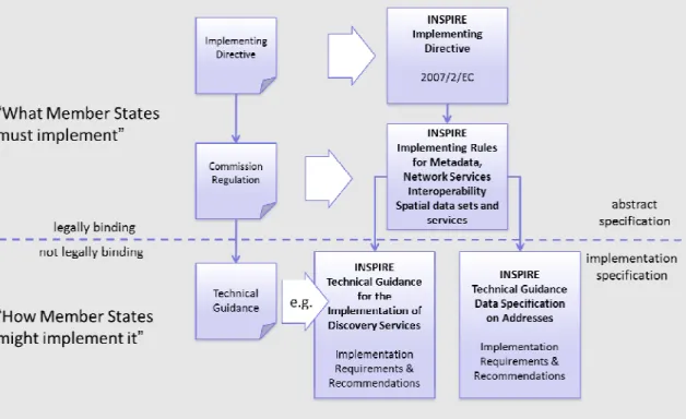
The schematic diagram in Figure 1 gives an overview of the relationships between the INSPIRE legal acts (the INSPIRE Directive and Implementing Rules) and the INSPIRE Technical Guidelines. The13 The INSPIRE Glossary is available from
INSPIRE Directive and Implementing Rules include legally binding requirements that describe, usually on an abstract level, what Member States must implement.
In contrast, the Technical Guidelines define how Member States might implement the requirements included in the INSPIRE Implementing Rules. As such, they may include non-binding technical requirements that must be satisfied if a Member State data provider chooses to conform to the Technical Guidelines. Implementing these Technical Guidelines will maximise the interoperability of INSPIRE spatial data sets.
Figure 1 - Relationship between INSPIRE Implementing Rules and Technical Guidelines
2.6.1
Requirements
The purpose of these Technical Guidelines (Data specifications on Statistical Units) is to provide practical guidance for implementation that is guided by, and satisfies, the (legally binding) requirements included for the spatial data theme Statistical Units in the Regulation (Implementing Rules) on interoperability of spatial data sets and services. These requirements are highlighted in this document as follows:
IR Requirement
Article / Annex / Section no.
Title / Heading
This style is used for requirements contained in the Implementing Rules on interoperability of spatial data sets and services (Commission Regulation (EU) No 1089/2010).
For each of these IR requirements, these Technical Guidelines contain additional explanations and examples.
NOTE The Abstract Test Suite (ATS) in Annex A contains conformance tests that directly check conformance with these IR requirements.
Furthermore, these Technical Guidelines may propose a specific technical implementation for satisfying an IR requirement. In such cases, these Technical Guidelines may contain additional technical requirements that need to be met in order to be conformant with the corresponding IR requirement when using this proposed implementation. These technical requirements are highlighted as follows:
TG Requirement X This style is used for requirements for a specific technical solution proposed in these Technical Guidelines for an IR requirement.
NOTE 1 Conformance of a data set with the TG requirement(s) included in the ATS implies conformance with the corresponding IR requirement(s).
NOTE 2 In addition to the requirements included in the Implementing Rules on interoperability of spatial data sets and services, the INSPIRE Directive includes further legally binding obligations that put additional requirements on data providers. For example, Art. 10(2) requires that Member States shall, where appropriate, decide by mutual consent on the depiction and position of geographical features whose location spans the frontier between two or more Member States. General guidance for how to meet these obligations is provided in the INSPIRE framework documents.
2.6.2
Recommendations
In addition to IR and TG requirements, these Technical Guidelines may also include a number of recommendations for facilitating implementation or for further and coherent development of an interoperable infrastructure.
Recommendation X Recommendations are shown using this style.
NOTE The implementation of recommendations is not mandatory. Compliance with these Technical Guidelines or the legal obligation does not depend on the fulfilment of the recommendations.
2.6.3
Conformance
Annex A includes the abstract test suite for checking conformance with the requirements included in these Technical Guidelines and the corresponding parts of the Implementing Rules (Commission Regulation (EU) No 1089/2010).