CITY OF BIXBY
REQUEST FOR PROPOSALS
UPDATE AND CONVERSION TO WEB-BASED
GEOGRAPHIC INFORMATION SYSTEM (GIS)
PUBLIC WORKS DEPARTMENT BEATRIZ AAMODT, P.E.
DIRECTOR
City of Bixby
Request for Proposal
1.0 INTRODUCTION AND SCOPE
1.1
Introduction
The City of Bixby seeks proposals from qualified firms to provide professional services pertaining to GIS services described in the Scope of Services section. This Request For Proposals (RFP) does not constitute a contract for services performed or to be performed. Following the selection of the consultant, the City will negotiate a finalized Scope of Services.
1.2
Issuing Organization
This RFP is initiated by the Public Works Department for the City of Bixby, Oklahoma.
1.3
Background Information
In 2003, the City of Bixby retained Meshek and Associates (Tulsa, OK) to implement a GIS program. Since then, the population of the City of Bixby has increased greatly, resulting in expansion of infrastructure and municipal services and requiring an increase in spatial data services and data management. Bixby’s GIS program has advanced only minimally in the face of these changes and growth. The City of Bixby anticipates the need to develop a two-tiered web-enabled system consisting of software and datasets for (1) employees (data editors) and (2) the public (data consumers). Software and datasets for both tiers should be accessible using mobile and desktop applications as the particular situations warrant. Recommendations on complete cloud data hosting options may be entertained.
To determine the best way to update and re-structure the GIS, an understanding of the activities and services (referred to as ‘government functions’) typically required by the City of Bixby is necessary.
These range of activities included within each government function are the basis for the development of GIS functional, application, and data requirements.
1.3.1 Administrative Services
Administrative Services within the City of Bixby is generally considered to encompass those areas of responsibility that provide specific management services in the areas of finance/accounting, general administration, and City Council support.
A) City Council Support
This function includes the following components:
• meeting coordination, agenda preparation, and issues reporting; • councilor correspondence;
• Mayor and individual Councilor support (specific Ward issues); and • elections, and electoral boundaries.
B) Financial Services
This function includes the following components: • accounting, payroll, procurement, cash management; • billing, revenue collection, administration of taxes
• capital budgeting, asset and debt management; and • customer service / inquiry.
C) General Administration
This function includes the following components:
• City systems and resources maintenance and administration • computer systems, network, and database management;
• human resources and labor relations (including support and training); and • legal services, contracts and litigation.
D) Economic Development
This function includes the following components: • special events coordination;
• development site location assistance; • community liaison; and
• development incentives and business recruitment and retention.
1.3.2 Protective Services
Protective services includes the police and fire departments
A) Law Enforcement Services
This function includes the following components: • policing and law enforcement;
• central dispatch; • investigations
• link to national police / crime databases;
• Motor Vehicle enforcement; traffic accident reporting; • special event routing;
• animal control; and • crime reporting / statistics.
B) Fire Protection Services
This function includes the following components: • fire and accident management;
• building floor plan maintenance; • emergency response;
• hydrant management and flow mapping; and • hazardous sites / materials inventory
1.3.3 Public Works and Engineering Services
This group of functions involves engineering related services including roads, water, sewer and storm water management.
A) Transportation Services and Storm Water Management This function includes the following components:
• road, bridge, street lighting operations management;
• R-O-W mowing; • snow removal;
• operation and maintenance of storm sewer system infrastructure; and • watershed management (MS4 compliance).
B) Water and Sewer
This function includes the following components:
• operation and maintenance of water distribution system infrastructure (supply / transmission / distribution / treatment / maintenance and water testing);
• operation and maintenance of sanitary sewer system infrastructure (collection / treatment / disposal / maintenance); and
• building maintenance.
C) Engineering Services
This function includes the following components: • utility coordination (OG&E, ONG, PSO, etc.); • As built Plans;
• Capital Improvement Plans;
• engineering design (utilities, road upgrades); • street access approvals;
• (coordination with state and other agencies (such as ODOT & ODEQ); • subdivision plan review; and
• construction inspections.
D) Building Permits
This function includes the following components: • permit processing, permit tracking;
• Building, Mechanical, Electrical, Plumbing, and Fire Code reviews and inspections; • environmental / municipal service approvals; and
• report preparation: Statistics to Council (monthly, year-end).
E) Cemetery
This function includes the following components: • cemetery mapping;
• sales of burial spaces; • deed tracking; and • burial Information.
1.3.4 Planning and Development Services
This group of government functions relates to the regulation of development including both the preparation and administrative aspects of land use plans, strategies and land use and development codes, address assignments, floodplain administration, and neighborhood and code enforcement services.
A) Land Use Planning
This function includes the following components:
• building permits, sign permits, and certificates of occupancy;
• Comprehensive Plan Map Amendment requests, PUD, Rezoning, Subdivision Plat, Board of
Adjustment, Detailed Site Plan, Lot-Split, Plat Waivers, and other development-related applications;
• public notices;
• right-of-way and easement closings, right-of-way and public property encroachment/License;
• statistics and projections for building permit, subdivision, residential lot inventory, and Census and other demographic data;
• coordinate Bixby’s ArcGIS-based Geographical Information Systems program; • prepare maps for planning and zoning, other departments, and the public as needed;
B) Addressing / E-911
This function includes the following components: • E-911 address assignments / reassignments;
• business and business license GIS database maintenance;
• information exchange (Tulsa City / County 911 Coordinator, Wagoner County 911 Coordinator, Bixby Postmaster, Oklahoma District USPS AMS Manager (Postmaster Coordinator), Tulsa County Assessor, telecommunications providers, police, fire, and ambulance/EMSA);
• street name assignment / changes; and
• maintenance of community boundaries; service area and emergency responder area boundaries.
C) Floodplain Administration
This function includes the following components: • Floodplain Regulations;
• provide flood information to the public, including Floodplain determinations; • comply with National Flood Insurance Program (NFIP) requirements; • review, correct, accept, or reject elevation certificates;
• administer FEMA grants; and
D) Neighborhood Services / Code Enforcement Services This function includes the following components:
• neighborhood and homeowners association coordination; • public relations and press release coordination;
• general code enforcement;
• dangerous and unsightly premise investigation / tracking; • illegal dump site investigation / tracking; and
• nuisance abatement.
1.3.5 Parks and Recreation
This includes services provided by Parks Department as well as functions related to the administration of parks and open space.
A) Parks Services
This function includes the following components: • trail systems planning;
• special event coordination;
• parks planning;
• sports field permits / booking;
• parks and sports field maintenance; and • parks supervision.
1.4
Scope of Services
The objectives of the public infrastructure inventory and related databases are to facilitate the City's management of the infrastructure and general services provision systems. Specifically, to facilitate a planned maintenance and capital improvement program as well as city-wide master planning. Furthermore, the objective of this project is to update the current GIS product to facilitate the easy dissemination of low-risk public information to the constituents of Bixby and the public at large.
1.4.1 Scope
The scope of the project can by summarized as follows:
A) Conduct an initial general needs assessment prior to proceeding with a GIS implementation project. The assessment should commence with a review of the existing GIS and determination of how it can be updated while incorporating all of the ‘government functions’ as the City of Bixby determines necessary.
B) Investigate the availability, accuracy, and currency of existing digital and paper map data.
C) Define the data (digital maps and attributes) needed for the GIS to extract information relevant to the functions and activities identified in each internal/external tier and ‘government function’ as the City of Bixby determines necessary.
D) Deliver a city-wide GIS plan that identifies a recommended implementation timeline, the general configurations of equipment, software, data, and expertise required to provide mapping support to the final ‘government functions’ and makes use of a web based digital mapping for both City
employees (data editors) and the public (data consumers).
E) Prepare an initial estimate of the storage requirements and cost associated with recommended new GIS products, and provide recommendations on the extent to which the data should be Cloud based.
F) Implement the GIS application requirements and deliver the data required to support the government functions and activities outlined in Section 1.3 as the City of Bixby determines necessary. Due to budget constraints, this will likely be implemented in Phases.
G) Train the City's initial phase designees in maintenance and upkeep once the GIS project has been implemented to ensure quality mapping and accommodate future expansion.
H) Provide recommendations and specifications for data acquisition and submittals to allow direct importation of new project information into the GIS system.
A description of the required applications and data is presented as guidance for the preparation of the Proposal. However, the Bixby Public Works Director and City Engineer will be ultimately responsible for performing a needs assessment and making recommendations to the City Council. The final scope of the project will be determined based on immediate needs and budget constraints.
1.4.2 GIS Application Requirements
the tasks that the GIS will perform when fully developed.
The operations are divided into three general categories based upon access characteristics:
• core applications that support multiple divisions within the City;
• workgroup applications are those that support operational requirements within a specific section of
the organization (i.e. public works); and
• external applications that are not directly municipal responsibility, but are highly interrelated (i.e.
utility underground cabling).
Table 1 summarizes the GIS applications identified by category and the government functions which it supports. The GIS implementation could be phased in, using the following ratings:
• (E) Essential - those applications that should form the basic framework for Bixby's GIS
installation;
• (D) Desirable - those applications that are an enhancement, but are of a lesser priority than the
essential applications; and
• (O) Optional - those applications that are lowest in priority but could be included if time and
resources permit.
The intent of the above ranking of applications is to provide the basis for the Proposer’s formulation of a phased GIS implementation plan that will ensure that those applications with the greatest impact on Bixby's operations are implemented first.
A) Core Applications
This section describes the core GIS application requirements for Bixby. While there may be departments that are dominant users, core applications are those that are used in support of government functions across most organizational units within the City of Bixby.
• Street and Address Mapping / Inquiry
This application provides the update and maintenance of the two main municipal map databases-the street file and the building location on the street with the address number.
• Parcel Mapping, Inquiry/Reporting
This application includes the ability to locate land parcels by direct selection and attribute query through one or a combination of Parcel Identification Database (PID), street address, owner name, parcel number, or other relevant particulars. The Parcel Inquiry/Reporting application involves the use of the Tulsa County and Wagoner County Assessors’ parcel data to display and report on property parcels.
• Boundary Mapping
This application will permit the update, display and inquiry of various administrative boundaries (ward and district boundaries, general service areas, area rate boundaries, community boundaries) within the City of Bixby. The Boundary Maps application includes the ability to overlay and query property parcels and topographic mapping as well as FEMA Floodplain contours.
• Service Infrastructure Inquiry
This application uses municipal utility infrastructure mapping for inquiry and analysis purposes. It includes the ability to display municipal service systems -water, storm and sanitary utility information -(main lines, manholes, valves, lift stations, hydrants, etc). This data takes on additional value when combined with other themes such as municipal street, address, property ownership and/or topographic base mapping.
• Permit System Integration and Inquiry
This application would encompass the entire range of functions required to build and maintain a municipal permit tracking system. The Permit System links permits to property parcels and addresses. It includes the ability to track applications, inspections, and approvals by type. The application further allows for the monitoring of subdivision activity by type. The permit system should be capable of maintaining variance and site analysis information. It could also allow for the input of building footprints and possibly digital or scanned images (e.g. photographs).
• Urban Topographic Mapping
This application includes the entry and updating of an urban topographic/planimetric database from field survey, photography, design plans and scanned “as-built” drawings. Features typically collected during this process are curb lines, hydrants, signs, trees, manholes, floodplains, catch basins, building footprints, utility poles and other relevant items. This application should include procedures for the upload of field survey data from GPS, monitoring stations and other field collection units. It can also allow for conversion of other map formats (raster to vector) and geo-referencing of existing maps and plans.
B) Workgroup Applications
Workgroup applications are considered to be those that are of primary interest to one government function.
• Administrative Services Area Rate Calculations
The Area Rate Calculation application includes the ability to identify properties within ‘service areas’ for services such as fire protection, street lighting, sewer, and fire hydrants. This application will allow for the overlay of these zones with the property layer and determination of the parcels that fall within each zone. Ward Boundaries can also be included in this application.
• Protective Services Emergency Service Areas
This application allows for the determination and revision of the response areas for fire, police and emergency services. The application provides the ability to allocate manpower and equipment based on map features such as area, buildings or street miles and to allow for reconfiguration (redistricting) during emergencies.
Incident Reporting
This application allows for the entering updating and analysis of traffic, crime and other emergency incident reporting using street or address information. This application provides monitoring and analysis capability for fire and police departments.
• Transportation, Public Works and Engineering Services Utility Inventory Management
This application consists of the ability to enter, update and maintain utility maintenance attribute information for water, storm and sanitary sewer main lines and service laterals, valves, manholes, catch basins, hydrants, etc. The typical information collected on utilities includes: pipe sizes and types, installation dates, contractor, inspection and maintenance records. This application will allow for the import of data from GPS receivers, total station units, and CAD files. The application will also allow for basic system network modeling (for example, modeling the flow through a water distribution system).
Road Infrastructure Management
This application involves the data entry, update, display, plotting and reporting of various road infrastructure databases that are associated with a digital street centerline network. The Road
Infrastructure Management application includes the ability to maintain a basic road network inventory (road name, address ranges, road class, length, jurisdiction, costs, etc), construction contracts,
pavement management (including surface type / condition, distress ratings, etc.) and road link data, such as traffic counts and volume/capacity ratios. Other road infrastructure items that are considered part of this application include culvert inventory, sign inventory, bridge inventory, and access control lines.
The Road Infrastructure Management application can also provide network routing capabilities to allow for the analysis of maintenance, R-O-W mowing, and snow plowing. The routing functionality should be considered as a future enhancement to this application.
Street Signs/Signals Inventory
This application will permit the update, inquiry and display of traffic signs, traffic signals and street light inventory data. Items should include, but not be limited to: stop signs, crosswalks, no parking signs, speed limit signs, traffic signals and street lights.
Cemetery
This application will permit the update, inquiry and display of cemetery lots, deeds, and sales.
• Planning and Development Services Zoning and Land Use Query
This application includes various functions to allow for the inquiry and reporting of land use categories. A key component of this application is to classify each parcel by its zoning district and land use categories. The Land Use Planning application includes the ability to query zoning, Board of Adjustment, and approval conditions of properties. As the property layer is essential to this
application, full display, inquiry and reporting of parcel information will be available.
Development Analysis
This application uses parcel layer data such as building permit information and land use data in order to monitor the direction and pace of development, the need for rezoning and plan amendment. Code Enforcement Reporting
This application includes the ability to display, update and maintain a code enforcement inventory database. The key to this application is to link each code enforcement case to a parcel through the use of the PID. The Code Enforcement Reporting application includes a city website complaint
submission function, complaint logging, follow-up visit tracking and tracking of patterns over time (repeat infractions, etc).
• Parks and Recreation
Recreational Facility Locations
This application includes the identification and update of recreational facility locations. The
Recreational Facility Locations application would include facility classification, ownership and land use, facility inventory maintenance, inspection status and deficiency identification.
Trails Inventory
C) External Application- Utility Integration
External applications are those for which the City of Bixby is not directly responsible, but may wish to import data from in support of its government functions.
• Power Utility Information Access
This application includes functions to import power utility infrastructure layers from OG&E, PSO and other power utilities. It also includes functions to display this information overlaid with other
municipal GIS layers.
• Telephone Utility Information Access
This application includes functions to import telephone utility infrastructure layers from BTC, AT&T, Windstream, Easytel, etc.
• Cable Utility Information Access
This application includes functions to import cable utility infrastructure layers from cable companies.
• Natural Gas Utility Information Access
This application includes functions to import natural gas utility infrastructure layers from gas pipeline utilities.
Table 1
GIS Applications by Category
CATEGORY APPLICATION F in an ci al S er v ic es A d m in is tr at iv e S er v ic es C o u n ci l S u p p o rt P u b li c W o rk s E n g in ee ri n g S er v ic es In sp ec ti o n S er v ic es A d d re ss in g /E 9 1 1 B u il d in g P er m it s C o d e E n fo rc em en t L an d U se P la n n in g D ev el o p m en t S er v ic es R ec re at io n S er v ic es P ar k s S er v ic es L aw E n fo rc em en t S er v ic es F ir e P ro te ct io n S er v ic es IM P L E M E N T A T IO N
Utility Infrastructure Inquiry X X X X X X X X E
Parcel Inquiry / Reporting X X X X X X X X X X X X X X X E
Boundary Maps X X X X X X X X X X X E
Address Mapping / Inquiry X X X X X X X X X X X X X X X E
Topographic Mapping X X X X X X X X X X X X E
Urban Topographic Mapping X X X X X X X X X X X X E
Core
Permit System X X X X X X X X X X X X D
Utility Inventory Management X X X D
Land Use Planning X X X X X X D
Road Infrastructure Management X X X X D
Street Signs / Signals Inventory X X O
Redistricting Analysis X X X X X X O
Voter Enumeration List X X O
Code Infraction Reporting X X X X O
Address Maintenance X E
Trails Inventory X X X X D
Recreational Facility Inventory X X X X X X X D
Workgroup
Cemetery Management X D
Power Utility Information Access X X X X X X X X X D
Telephone Utility Information Access X X X X X X X O
Cable Utility Information Access X X X X X X X O
External
Natural Gas Utility Information Access X X X X X X X X D
1.4.9 GIS Data Requirements
This section describes the GIS requirements for data - what information would it use and where is it available. The data requirements are broken down into three areas by availability and maintenance responsibility: county mapping, municipal mapping and utility mapping.
The GIS data requirements for municipal mapping and utility mapping are summarized within tables for each of the above mentioned areas.
A) County Mapping Data
Databases within this category are available from Tulsa County and Wagoner County. For each of these, the City of Bixby has an agreement for the ongoing maintenance of the mapping and any attribute data that is associated with it.
• Aerial data
The most current 2010 color data from INCOG (flown by Aerial Data Systems of Tulsa) in MrSID format.
• Tulsa County Assessor’s parcel data
This data is gathered by INCOG on a quarterly basis, made available to Bixby upon request. Latest parcel data available is August 2012
• Wagoner County Assessor’s parcel data
This data is received from INCOG annually.
• Planning and development services data
This data is from the County Assessor's via INCOG:
Subdivision Plats Zoning PUDs City Limits/Boundaries Ward Boundaries • E-911 street
The data is maintained by INCOG and received annually
• Floodplain
This data is received from FEMA
• Census Data
This data is received from the U.S. Census Bureau and is made available periodically
B) Municipal Mapping Data
This section provides an overview of municipal mapping that is needed to support municipal GIS applications previously described within this document.
Bixby implemented GIS in 2003; however, the System has not been updated much since then. Some data was compiled but never included in the final GIS. The Consultant is responsible for assessing the existing GIS and incorporating existing and new data as required by the City. It may be necessary to construct new layers and change exiting layers as part of updating the GIS.
The City of Bixby has compiled and maintained additional data to incorporate:
• Land Use - data mostly completed for Bixby “Annexation Fenceline”
• Business data - includes all known address points, current and last known occupants, contact
• Communications towers data - includes year built, height, FAA Registration numbers, etc. as
available.
• Lift Station data - includes name, SCADA system information if applicable, X/Y
coordinates, and miscellaneous information such as power output and power requirements
• Warning Sirens data - includes install dates, model numbers, etc. • Critical Facilities - for Multi Hazard Mitigation Plan purposes
• Trails data - includes existing and planned, current status, and plan sources such as City of
Bixby Comprehensive Plan, INCOG, etc.
• City Parks - includes park areas
Table 2
Municipal GIS Mapping Requirements Mapping
Database
Layer Major Features
Water Water mains, laterals, fire hydrants, valves, water supply meters, private water system meters, pump stations
Sanitary Sewer
Sewer mains, laterals, manholes, lift stations, treatment facilities
Municipal Utilities
Storm Sewer Mains, laterals, inlets, catch basins
Watersheds Watersheds Watershed polygons
Recreational Facilities
Recreational Properties
Recreational properties polygons
Fire Fire Hydrants Area polygons
Traffic Control Signs Sign locations
Signals Signal locations
Road Inventory Culverts Culvert locations, size, type, inspection data
Curbs Linked to road centerline features
Bridge Inventory Bridges Bridge locations, size, type, inspection data
Cemetery Lots Cemetery Lots Cemetery lot locations
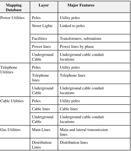
C) External Mapping Data
This section provides an overview of additional mapping requirements. These are associated with the location of other utilities: power, telephone, cable, and natural gas. Some of this information may currently be available in digital form from third parties.
Table 3 External GIS Mapping Requirements Mapping
Database
Layer Major Features
Poles Utility poles Street Lights Linked to poles
Facilities Transformers, substations Power lines Power lines by phase Power Utilities
Underground Cable
Underground cable conduit locations
Poles Utility poles Telephone lines Telephone lines Telephone Utilities Underground Cable
Underground cable conduit locations
Poles Utility poles Cable lines Cable lines Cable Utilities
Underground Cable
Underground cable conduit locations
Gas Utilities Main Lines Main and lateral transmission lines
Distribution Lines
1.5
Current Technology Architecture
Existing hardware (computers, plotters, printers, scanners, etc.) and network configurations will be identified by the Consultant before finalizing Service Agreement. Existing software should be identified (operating systems, word processing, spreadsheets, databases, E-mail, CAD systems, etc.) in relation to the functions they support within Bixby's operations.
It expected that the hardware and software will support a full GIS System with capabilities to Read, Edit, and Analyze data as well as be available via the Web. The Consultant will be expected to make recommendations regarding the technology that will accommodate current and future needs.
2.0 PROPOSAL PREPARATION AND SUBMISSION
2.1
Proposal Requirements
2.1.1 Pre-proposal Meeting
Firms planning to submit proposals are encouraged to attend, in person, the pre-proposal conference held at the City of Bixby, 116 W. Needles Ave., Bixby, Oklahoma. The meeting will be held in the Council Chambers at 10:00 a.m. on December 5, 2012.
2.1.2 Proposal Submission
One (1) original with six (6) copies and one (1) copy on CD in Portable Document Format (PDF) of your proposal must be submitted on or before 10:00 a.m. on January 11th, 2013 to:
By Hand Delivery: Mrs. Beatriz Aamodt, P. E. Public Works Director City of Bixby
116 West Needles Bixby, Ok 74008
By Mail Delivery: Mrs. Beatriz Aamodt, P. E. Public Works Director City of Bixby
P.O. Box 70 Bixby, OK 74008
Electronically transmitted proposals will not be considered. Consultants are solely responsible for the timeliness of their submittals.
2.1.3 Evaluation Process and Selection Criteria
All proposals meeting the requirements of this RFP shall be reviewed and rated by a Department evaluation committee according to the following criteria:
• Experience of the firm
• Experience and qualifications of the personnel • Team availability
• Project approach, work plan, timeline, deliverables and project management • Understanding of the project
• Quality, completeness, and responsiveness of the proposal • Administrative requirements.
Selected proposers will be contacted to arrange in-person interviews with the evaluation committee. The evaluation committee will make the final recommendation for selecting the consultant. All
recommendations are subject to the approval of the Public Works Director and City Engineer.
Proposers are advised that any information submitted as part of this request for proposal becomes public information and may be released without further notification. Any information that the proposer
considers confidential should not be submitted with the proposal.
The issuance of the RFP does not commit the City of Bixby to award a contract with any bidder. If selected, the bidder will be required to enter into contract negotiations with the City of Bixby to resolve any revisions to the original submission as well as discussion regarding budget and pricing, prior to contract award.
2.1.4 Proposal Content
The following items shall be included in the proposal:
A) Cover Transmittal Letter
Provide a narrative which introduces the firm and team highlighting the special strengths of the firm to perform the work requested in this RFP. The letter should be signed by an authorized principal of the proposing consulting firm.
B) Firm Qualifications, Experience and References
Provide a narrative describing the firm’s qualifications to perform the project work, including past (relevant) experience and at least three client references, with contact names and information. Include information regarding the firm’s experience involving the size and level of complexity of the proposed project with particular emphasis on any prior experience in a city environment. Qualifications and experience for proposed sub consultants should also be included.
Additionally, include a narrative of your firm’s expertise in the following areas:
• ESRI GIS Development • ESRI/AutoCAD Integration • ESRI/INCODE Integration
• GIS Standards and metadata development and execution.
• GIS applications for public works departments.
• Experience with mapping displays, including handheld, desktop and web-based interfacing. • Integration with other database management systems.
• Experience with governmental GIS application development. • Experience with the City of Bixby GIS, if applicable
C) Project Organization, Personnel and Staffing
Provide a brief description of all key personnel and technical staff (including, vendors, partners or subcontractors) to be involved and their relationship to the services to be provided.
• Include names, title, licenses, and certificates, fields of expertise, and relevant state and
local area experience for all proposed personnel and staff.
• Identify the principal-in-charge for the proposed services.
• Complete resumes for proposed staff should be provided as part of an appendix to the
proposal.
• Provide a project organization chart which depicts the organization of the project team, including reporting relationships to the Public Works Director, and project team staff.
• Indicate the on-site availability for project manager as well as other staff during the lifetime of the project.
D) Project Approach, Work Plan, and Deliverables
Provide a narrative which shows your firm’s understanding of the project’s requirements and documents a logical technical approach to the project scope of work. Include a general work plan as well as the proposed approach to undertaking the scope of work described earlier in this RFP.
• Using the scope of work presented in this RFP, propose a work plan detailing major tasks and subtasks and the work to be conducted in each. For each task, detail the number of hours by staff level and the hourly rate for each staff level.
• If specific project team members or vendors are critical to specific tasks, identify where
they will be utilized and/or committed.
• Include the results and deliverables expected from each major task. NOTE: Payment will
be tied to the successful completion and acceptance of deliverables.
• Identify appropriate assumptions and considerations that could impact the scope and
timeline for completing each task.
• Provide a detailed equipment list for each application area with associated costs.
• Provide a detailed list of estimated expenses by category. Identify related considerations
and assumptions for these expenses.
E) Project Management and Invoicing
Describe how your firm intends to manage all aspects of the work to be performed including schedules for completion of tasks/subtasks, procedures for scheduling and cost control. The Project Management Proposal must include:
• Project kick off meeting.
• Regularly scheduled project team meetings.
• Written progress reports.
• Issue/risk management techniques. • Progress reports.
• Invoicing system to support all work conducted and all associated equipment invoices and
packing slips.
• Deliverable based invoicing.
F) Timeline
Based upon the proposed project approach and work plan, provide a detailed project schedule that illustrates the duration of each task/subtask and identifies results and deliverable milestones.
2.1.5 Checklist for RFP Submittal Requirements
A checklist is provided to assist in verification that all elements of the RFP have been addressed. However, firms are encouraged to review the entirety of the RFP to ensure full compliance and not rely solely on the checklist.
• Cover transmittal letter, signed by an authorized principal of the proposing consulting firm. • Table of Contents, if included (not required).
• Proposal with the following sections, in order:
Firm Qualifications, Experience and References
Project Organization, Personnel and Staffing
Project Approach and Work Plan
Project Management and Invoicing
Proposed Application and System Support Requirements
Timeline
• Resumes for all proposed staff personnel provided in an appendix.
3.0 TERMS AND CONDITIONS
3.1
Inquiries
All inquiries related to the RFP shall be directed to:
Mrs. Beatriz Aamodt, P. E. Public Works Director City of Bixby
116 West Needles Bixby, Ok 74008 baamodt@ bixby.com
Please refer to specific sections of the RFP document for ease of response.
3.2
Presentation / Demonstration
The City of Bixby may request a formal presentation and/or demonstration of the proposed GIS solution before selecting a consultant.
3.3
Subcontracting
Utilizing a subcontractor (who must be clearly identified) is acceptable; however, the lead bidder is ultimately responsible for the proposed GIS solution. Maintenance and support of software components may be provided directly from the software provider.
3.4
Proposal Closing
Proposals must be submitted in a sealed envelope with the proposal title and closing date clearly identified. Late proposals will not be accepted.
3.5
Proposal Information
3.6
Proposal Costs
The Bidders will assume any and all costs incurred with preparing and presenting the proposal to the City of Bixby.
3.7
Statement of Liability
The City of Bixby shall not be deemed liable for any software/hardware delivered by the successful bidder until the complete GIS system has been accepted by the City of Bixby.