Geography Grade 13 Teacher s Guide.pdf
240
0
0
Full text
(2) GEOGRAPHY G.C.E. Advanced Level. Teachers’ Instructional Manual Grade 13. Department of Social Sciences Faculty of Languages, Humanities and Social Sciences National Institute of Education.
(3) PREFACE This Teachers’ Instructional Manual will be useful for the teachers to organize the teachinglearning process for Grade 13 from the year 2010. This syllabus that is taken as the base for the compilation of this book is distinct from the syllabi that were in effect earlier. You, who will concentrate on it will realize that it is a competency based syllabus. It is not expected that the achievement of every competency seen here should be gained in the same grade. Sometimes it may take a longer time. However, the competency levels and the learning outcomes indicated under each of the competency levels have to be achieved during that grade itself. Hence those competency levels and learning outcomes will be of immense use to you in planning the relevant lessons for the grade. It is expected that you should draw your attention in using them as criteria when preparing each of the aims in the teaching-learning process as well as in setting the evaluation tools to be used in the classroom. This Manual will be every useful to you in making the students aware of the supplementary books that have to be read in learning this subject as well as the web-sites to be surfed. Consider these activities proposed here with the expectation that you will act as a creative teacher. It is especially expected that you will be able to create a student-centred classroom process that prevailed. Hence you should make an attempt as far as possible to create learning situations where students are motivated to refer various books and to lead them in exploration by using the internet. In teaching, instead of giving notes as traditionally done, you should present principles with the new knowledge in an attractive manner. In this regard use of communication strategies in the class where technology is included as far as possible. It requires some creativity to use new technological instruments as far as possible. Explain this curriculum to your students who start learning this subject in Grade 12. If you could introduce the plan of teaching for the whole year it will motivate them. Students will be attracted to attend school to cover up the syllabus. We make a request from you to awaken your creative abilities with the help of these proposed activities and also the relevant syllabus in order to make a change in the teaching-learning process. I offer my thanks to all the Educationists, teachers and all the officers in the National Institute of Education who contributed in compiling this Instructional Manual. I offer my special thanks to Professor Lal Perera, the Director General who guided us in this task as well as the Commissioner General of Educational Publications Department including his staff who undertook the responsibility of doing all the printing and distribution of books to the schools. I shall be grateful if you could direct any creative suggestions regarding the information included here. Wimal Siyambalagoda Assistant Director General Faculty of Languages, Humanities and Social Sciences National Institute of Education. ii.
(4) Resource Contribution Consultancy: Dr. Upali M. Sedara Wimal Siyambalagoda. - Director General, National Institute of Education - Assistant Director General, National Institute of Education. Subject Advisors: Emeritus Professor M.M. Karunanayaka Senior Professor N.K. Dangalla Professor .D.C.Abhayaratne Professor Upali Weerakkody Professor V. Nandakumar Coordination: Ms. K.A.L. Geethani. -. University of University of University of University of University of. Sri Jayawardenapura Kelaniya Sri Jayawardenapura Ruhuna Peradeniya. - Assistant Project Officer, National Institute of Education. Subject committee Ms. M.P. Ranjani Dhanawardene- Chief Project Officer, National Institute of Education Ms. K.A.L. Geethani - Assistant Project Officer, National Institute of Education Mr. S. Karunakaran - Assistant Project Officer, National Institute of Education. Panel of Writers: Mr. R.P. Peiris - Retired Additional Commissioner of Examinations Mr. M.K. Kingsly Priyantha - Lecturer, NCOE Pulathisipura Mr. F.M. Nawasdeen - Lecturer, Open University Mr. S.M. Dayananda - Retired Project Officer, National Institute of Education Mr. E.M. Nawaratna Banda - In-Service Advisor, Galenbindunuwewa Zone Mr. J.A.B. Heenkenda - In-Service Advisor, Kandy Zone Mr. K.K.U. Gunaratne - SLTS, Polpagoda Navodya School, Yakkalamulla Ms. W. Walpitage - In-Service Advisor, Matugama Zone Ms. M.V.A. Suwarnalatha - SLTS, Padagoda M.V, Beruwela Mr. D.W.G. Jayantha Bandara - Teachers Service, Chief Minister’s College, Athurugiriya. Ms. M.P. Ranjani Dhanawardene- Chief Project Officer, National Institute of Education Ms. K.A.L. Geethani - Asst. Project Officer , National Institute of Education. Editing Subject Committe. - National Institute of Education. English Translation Senior Professor N.K. Dangalla - University of Kelaniya Lecturer H.IG.C. Kumara - University of Ruhuna Mrs. R.A.W.D. Jayawardana - English Advisor, University of Rununa. iii.
(5) Cover Creation Ms. M.N.F. Rihana. - Dept. of Social Sciences, National Institute of Education. Computer Setting Senior Professor N.K. Dangalla Ms. R.A.W.D. Jayawardana Ms. M.N.F. Rihana. - University of Kelaniya - English Advisor, University of Rununa - Dept. of Social Sciences, National Institute of Education. Other Assistance Miss Sandya Atapattu Ms. S.D. Samarakkody Mr. R.M. Rupasinghe. - Dept. of Social Sciences, National Institute of Education - Dept. of Social Sciences, National Institute of Education - Dept. of Social Sciences, National Institute of Education. iv.
(6) CONTENTS. Page Number Foreword. i. Preface. ii. Contributing Resource Persons. iii. Guidelines to clarify subject content and Teaching Activities. Physical Geography. 1 - 67. Human Geography. 68 - 179. Practical Geography. 180 - 213. School-based Assessment - Introduction. 214 - 216. School-based Evaluation. 217 - 219. v.
(7) Geography I - Physical Geography Competency 8.0. 9.0. Contributes in the conservation of water in Sri Lanka.. vi. Examines the components, characteristics and processes in the physical, Human landscape and contributes to the conservation.. Subject Content. Competency Level 8.1 Examines the hydrological • properties of Sri Lanka.. Water resources of Sri Lanka • Surface water • Ground water. 8.2 Explains the importance of water conservation in Sri Lanka.. •. Water conservation. No. of Periods 10. 06. 9.1 Explains the world distribution of biomes and their characteristics.. •. Distribution of biomes • Tropical forests • Temperate forests • Mediterranean woodlands • Grasslands and savannah • Taiga forest • Deserts • Tundra. 10. 9.2 Explains the distribution and characteristics of biomes of Sri Lanka.. •. Distribution of biomes in Sri Lanka • Forests • Woodlands • Grasslands • Wetlands. 16.
(8) No. of Periods. Competency. Competency Level. 10.0 Examines how the interactions of physical and human activities make an impact on the physical and human environment.. 10.1 Explains with examples how natural hazards occur in the world.. •. Natural hazards in the world • earthquakes • cyclones • drought • lightning • avalanches • landslides • tornadoes • floods • wildfire • tsunami. 10. 10.2 Examines the physical and human impacts caused by natural hazards in the world.. •. The. - physical impacts - human impacts caused by natural hazards. 06. 11.1 Contributes actively in the management of natural hazards that occur in Sri Lanka.. • •. Natural hazards management in Sri Lanka Natural hazards management cycle • facing the hazard • assessing the danger • strategies in minimizing the danger • making awareness • awareness and use early warning systems. 12. Subject Content. vii 11.0 Acts with positive attitudes which help in the conservation and maintenance of the physical and human landscape..
(9) Competency. 11.2 Evaluates the strategies adopted for management and conservation of eco-systems in Sri Lanka.. viii. 11.3 Examines the relevance of Declarations, conventions and Draft schemes etc. concerning environment which have an influence on Sri Lanka. 12.0 Acts showing concern and attention on the earth and its inhabitants in order to promote harmonious interrelationship between nature and society.. Subject Content. Competency Level. 12.1 Examines the role of international and Regional organizations which are concerned about issues of ecological importance.. No. of Periods. •. Selected eco-systems in Sri Lanka • Wetlands coast • Forests and Wildlife Reserves • Bio-systems in water-bodies/ tanks • Environmental concepts and Ethics. 08. • • • •. Forests and wildlife Climatic changes Wetlands Chlorofluro Carbon (Cfcs). 08. •. South Asian Cooperation for Environmental Programme (SACEP) United Nations Conference on Environment and Development (UNCED) United Nations Environmental Programme (UNEP) Inter-Government Programme on Climatic changes (IPCC) International Union for Conservation of Nature (IUCN) National Aquatic Resources Research Authority (NARA) Central Environmental Authority (CEA) International Water Management Institute (IWMI) Coast Conservation Department (CCD). 20. • • • • • • • •.
(10) Geography II - Human Geography Competency 7.0. Examines the recent trends in agriculture and contributes to agriculture with effective ways.. Subject Content. Competency Level. No. of Periods. Explains the nature of world agriculture in relation to technology, production and marketing.. •. World agriculture • Agricultural technology • technology related to the Green Revolution • Gene technology • Expansion in Production (wheat, paddy, vegetables, fruits, fish and animal husbandry, cattle, poultry, pigs) • Increasing yields • Extension of cultivated lands • Short term yields • Process of string and Processing • Marketing process • Policies • Multi-national companies • agro-plantations • agricultural organizations • market information. 14. 7.2. Explains the nature of agriculture in Sri Lanka in relation to technology production and marketing.. •. Agriculture in Sri Lanka • Agricultural technology • Use of modern machinery • green revolution • gene technology • use of organic fertilizers • irrigation technology. 20. ix. 7.1.
(11) Competency. Subject Content. Competency Level •. •. No. of Periods. Increasing Production • Extension of land area • Increasing yields • Cutting down wastage • Use of modern machinery Marketing process • Economic Centres • Agreements with private organization • Drawing attention on quality • Showing concern on consumer taste and convenience. x 7.3. 8.0. Examines the trends in mines and activities and contributes to protection.. 8.1. Studies the recent trends in the agricultural land utilization in Sri Lanka.. •. Studies the nature and distribution of the world mining Industry.. •. Land utilization Gradual loss of agricultural lands Introduction of substitute crops Introduction of seasonal crops. 03. The main mine and related Products • petroleum • Coal • iron • copper • gold. 05. • • •.
(12) Competency. 9.0. Subject Content. Competency Level. No. of Periods. xi. 8.2. Analyses the trends in the world mining industry with reference to production and trade.. • • • • •. Distribution Production and other industries related to it Trade Problems in mining Hazards. 05. 9.1. Examines the distribution of mineral resources in Sri Lanka.. •. Mineral resources of Sri Lanka • gems • mineral sands • iron • plumbago • apatite distribution production trends. 06. 9.2. Emphasizes the importance of mineral resources in the Economy of Sri Lanka.. •. The Economy of Sri Lanka and mineral resources • as an industrial raw material • value addition related to changes in utility • employment • for regional development • contribution to national income. 04. Examines the value of mineral resources in the Economy of Sri Lanka and usest those effectivily..
(13) Competency. Subject Content. Competency Level 9.3. Takes action to minimize the damages to the environment in the utilization of mineral resources of Sri Lanka.. •. •. xii. 10.0 Examines the locational process of industries and presents suggestions to promote the industries of Sri Lanka.. No. of Periods. Utilization of mineral resources and its environmental impact • impact on drainage • impact on landscape • impact on health Minimizing environmental damage • promoting eco friendly attitudes • implementing the relevant legislation political dedication • political dedication. 10. 10.1 Examines with examples the factors of location of industries in the world.. •. The factors that influence the location of manufacturing industries in the world • iron and steel • motor vehicles, ships, aeroplanes • electronic industries • perto-chemicals • milk products. 10. 10.2 Examines the factors of location of a few industries in Sri Lanka.. •. Industries of Sri Lanka • Traditional handicrafts • Cement • Sugar • Garments. 10.
(14) Competency. Subject Content. Competency Level •. •. xiii. 11.0 Examines the Potentials in Sri Lanka for the Tourist Industry and presents suggestions.. 12.0 Examines the nature of globalization comparatively and presents examples which could apply to Sri Lanka. No. of Periods. Industries related to rubber and plastic • factors of location • specialized factors • current change State Policy related to the location of industries. 11.1 Examines the features of the Tourist industry in Sri Lanka.. • •. Present status of the Tourist Industry The impact of the Tourist Industry • economically • culturally and socially • environmentally. 07. 11.2 Proposes course of action that could be adopted in promoting the tourist industry of Sri Lanka.. •. Action that could be taken in the development of the tourist industry.. 03. 12.1 Examines information technology as a factor which influences globalization.. • • •. . What is Information technology What is globalization The impact of information technology on globalization. 10.
(15) xiv. Competency. Competency Level. 13.0 Examines the contribution of information technology on the socio-economic transformation in Sri Lanka and contributes to it. 14.0 Examines the role of multi-national corporations in international trade and Contribute to empower the nation’s economy 15.0 Examines the role of Regional organizations and tends to regional coorporation.. 13.1 Examines comparatively how information technology has influenced the socioeconomic transformation in Sri Lanka.. Subject Content •. No. of Periods. The use of information technology in the socio-economic changes in Sri Lanka • Economic • Political • Cultural • Social. 10. . 14.1 Examines comparatively the impact of multi-national trade.. •. International Trade • In capital investment • In transfer of technology • In the extraction of resources. 10. 15.1 Examines the functions of a few selected Regional Organizations.. •. In management • Regional organizations • Sourth Asian association for Regional Cooperation • South East Asian Association • European Community • North American Free trade Association • African Economic Commission. 10.
(16) Geography III - Practical Geography Competency 4.0. Uses statistics and graphical methods in analyzing, interpreting and presenting data and information.. Subject Content. Competency Level 4.1. Examines data sources.. •. Identifying data • Definition • Special characteristics of data • Type of data • Data bank • Data generation • Classification and Tabulation • Presentation of data. No. of Periods 10. 15 xv. 4.2. Examines methods of collecting data.. •. Collection of data • What as meant by a sample • Observation • Measurements • Discussions • Questionnaires • Library sources • Computerized sources • Maps, aerial photographs, satellite images, and pictures.
(17) Competency. Subject Content. Competency Level 4.3. Analyses and interprets data.. •. xvi •. Analysis and interpretation of data • Organising and tabulating data - Frequency Table Preparation • Using simple statistical techniques for spatial data • Central tendency −mode - mean −median • dispersion measurement - Range - Quartiles - Inter quartile range - Mean deviation - Standard deviation Representation of data • Graphs and Diagramms-Introduction • Graphs - Histograme - Frequency Curve -Frequency Polygon -Cumulative Frequnce and Percentage Cummulative frequency. No. of Periods 16.
(18) Competency 5.0. Shows correctly the spatial distribution of the physical and human components of the world.. Subject Content. Competency Level 5.1. Marks and names on outline maps of the world locations and distributions.. • Diagramms * One Dimentional Diagrams -Bar diagrams (simple, complex, pyramid) - Scatter diagram * Two Dimentional Diagrams - Wheel diagrams - Linear diagrams. No. of Periods 16. xvii. * Three Dimentional Diagrams * Pictorial Diagrams * Choropleth maps & Isopleth maps. •. Marking on outline maps of the world • Places and regions of geographical importance • Principles of map marking and activities. Note: It is expected that during particular teaching learning situations, the distribution maps relevant to all the units should be mapped out and interpreted..
(19) Geography - I Physical Geography. xviii.
(20) Competency – 8 Contributes to the conservation of water resource of Sri Lanka Competency Level. 8.1. Examines the hydrological properties of Sri Lanka (Number of periods 10). Learning outcomes § § § § § §. Describes ground water of Sri Lanka quantitatively. Explains the nature and sources of ground water of Sri Lanka. Explains the relationship between water utilization and varied human activities in Sri Lanka. Distinguishes ways of water pollution with examples. Points out the prospect need of water conservation. Suggests the ways that should be followed for water conservation.. Introduction Sri Lanka is rich in water resource. The water resource of our country is fed by the consistent heavy rains brought by monsoon winds, inter-monsoon rains, and depressions. Rain serves as the key factor of distinguishing the climate zones of Sri Lanka. Water, which is essential for the existence of human beings, is considered the vital resource of all the resources of the earth. Considering the water distribution, water can be classified into two as, surface water, for example, water in rivers, streams, brooks, lakes, lagoons etc., and ground water, which is stored within the earth. The objective of the lesson is to examine comprehensively the amount of water resource of Sri Lanka, its distribution, and the ways of utilizing water resource.. A guide to identify with the subject matter The water resource of Sri Lanka is determined by the rainfall. Rainfall of Sri Lanka Sources of rainfall Inter-monsoons Southwest monsoons Northeast monsoons Depressions. 1.
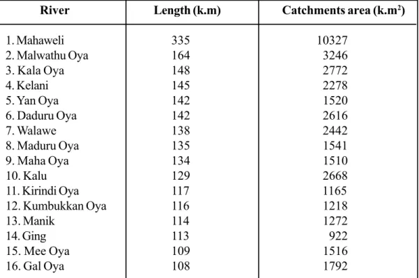
(21) Period of rainfall Inter-monsoons 1(March- April) Southwest monsoons (May- September) Inter-monsoons 2 (September- November) Northeast monsoons (November- February). Amount of rainfall Average annual rainfall 2000 mm West hill slopes - over 5000 mm (e.g. Malimboda) East hill slopes - under 3500 mm Least rainfall in southeast and northwest coasts – 935 mm (e.g. Ambalanthota). Rainfall zone Wet zone – >2350 mm Intermediate zone – 1450 mm Dry zone – 1000 – 1450 mm Arid zone - < 1000 mm. According to the place where water resource is stored, it can be classified into two. Surface water (Subaerial water) Ground water. In accordance with the quality of water, it can be categorized into three groups. Fresh water Salt water Brackish water. Surface (Subaerial) Water Surface water is the water found in rivers, streams, brooks, lakes, and lagoons. Most of the surface water is fresh. In lagoons, the water is a combination of salt and fresh water known as brackish water. Rivers in Sri Lanka - There are 103 main rivers in Sri Lanka. Of these, eighty belong to the dry zone and many are not perennial (seasonal rivers). - The rest are in the wet zone. These can be considered perennial rivers flowing throughout the year (perennial rivers). - Mahaweli is the longest of all and it is nourished by both the wet and the dry zones. It is 335 km long and the catchments area spreads over about 10327 km2.. 2.
(22) Map 8.1.1 Distribution of river basins of Sri Lanka. Source: Arjuna’s Atlas Sri Lanka (1997). 3.
(23) Table 8.2.1: Length of the rivers (>100m) and spread of catchments areas (k.m2) River 1. Mahaweli 2. Malwathu Oya 3. Kala Oya 4. Kelani 5. Yan Oya 6. Daduru Oya 7. Walawe 8. Maduru Oya 9. Maha Oya 10. Kalu 11. Kirindi Oya 12. Kumbukkan Oya 13. Manik 14. Ging 15. Mee Oya 16. Gal Oya. Length (k.m) 335 164 148 145 142 142 138 135 134 129 117 116 114 113 109 108. Catchments area (k.m2) 10327 3246 2772 2278 1520 2616 2442 1541 1510 2668 1165 1218 1272 922 1516 1792. - Most of the rainfall received to the earth is carried off to the sea by rivers and it is called the runoff. - Runoff in the wet zone is higher than that of the dry zone. The runoff of the river Nilwala is 1152 million cubic meters and it is 49% as a percentage while the runoff of the river Mahaweli is 4009 million cubic meters and it is 20%. Interior water reservoirs of Sri Lanka - Lakes and ponds are interior water reservoirs. Total land in Sri Lanka is 65610 km2 and out of it, 2905 km2 is covered by interior water reservoirs. - The North Central province possesses the highest rate of land covered with interior water reservoirs, and it is 731 km2. The Sabaragamuwa province has the least rate of all the provinces, which is 47 km2.. - Lagoons Lagoon, which is separated by sand ridges or a beach from the sea, consists a narrow opening known as an outfall. In a lagoon, there is brackish water and short rivers flow to some lagoons. Some of the main lagoons in Sri Lanka are Batticaloa, Puttalam, Lunawa, Bolgoda, Dedduwa and Kalamatiya.. 4.
(24) Map 8.1.3 Distribution of ground water of Sri Lanka. Source: Arjuna’s atlas Sri Lanka (1997). 5.
(25) Ground Water - The water that trickles into the earth depends on porosity and permeability of the earth. Porosity is the amount of pores in the rock. Permeability is the ability to trickle through the joints and pores. - The main contributing factor of the ground water level of Sri Lanka is the rainfall. The distribution of ground water is connected with the geological structure. - The island can be divided into three main geologic zones in relation to ground water. 1. Miocene limestone belt spreads over Puttalam to Jaffna and then to Mulathev. The ground water stored along this margin is obtained from jack-wells (Ândia wells). 2. Along the Eastern, North-eastern, and Western coasts, there is 3-5 m amount of ground water, which is obtained from shallow wells. 3. In the other regions of the island, the bedrock is hard and almost 80% of Sri Lanka belongs to this zone. Ground water gathers round the joints of these rocks. Methods of obtaining ground water - By shallow wells These are the most common wells in the island. Shallow wells are used to obtain fresh water stored in regions full of bedrocks such as granite, nice etc., flood plains and regions associated with river valleys and in coastal areas. - By tube wells Mass amount of ground water is found among pores, joints, and cleavages in hard rocks. In dry zones, tube wells are used to obtain this type of water. - By artesian-wells The river basins in some areas of Sri Lanka are compressed and water naturally wells up the Earth’s surface as these places are incised to the aquifer. These are called artesian wells, E.g. Mulathew, Palavi, Murugan - By deep wells Since drainage on the Earth’s surface is not possible in regions where limestone is common, ground water is stored in mass amounts in these areas. Thus, in Northwestern and Northern provinces ground water is obtained by deep wells. - By fountains Fountains are common in highlands due to its relief. Sources of water for the people in these areas are fountains.. 6.
(26) - By hot springs Hot springs can be seen in Kinniya, Maha-oya and Mahapellasse situated to the east of the river Walawe.. Water utilization in Sri Lanka - Water is used for various purposes. § § § § § § § §. Drinking water Domestic work Agriculture Hydro-electricity generation Industry Fishery (fresh water and associated with lagoons) Tourism (minimum) Transportation (minimum). - Percentage utilize § § §. Agriculture Domestic Other. 85% 6% 9%. Source: New prospects for water resource, Ministry of Water Resource Management - Per capita water utilization of Sri Lanka is 31 litres per day. But the required quantity is 50 litres per day. 7.
(27) Competency Level. 8.2. Defines the importance of water conservation in Sri Lanka (Number of periods 06). Objectives § § §. Understands how the water resource in Sri Lanka is polluted. Identifies the future need for water conservation. Suggests the possible ways that should be followed to conserve water resource of Sri Lanka.. Introduction As water resource of Sri Lanka could be directly utilized before several decades, there were not problems of water conservation. Yet, at present, surface as well as ground water is being polluted due to diverse causes. The process of water pollution is rapidly increasing with the increasing complexity of human activities. Water pollution can happen naturally or owing to human activities. In our country, large amount of water is wasted due to over utilization and improper use. Thus, need to conserve the water resource of Sri Lanka has become vital. Studying the need for conserving water resource and importance of taking necessary actions for that are focused in conservation of water resource of Sri Lanka. Water pollution - Several decades ago, both surface and ground water resources could have being utilized directly for human activities. Yet, presently, water in most of the rivers, streams, brooks, and open fountains cannot be used in the same way. E.g. Bere Lake, Kandy central brook - Due to water pollution, the quality of water decreases as well as it becomes unhygienic. There are two main reasons fro water pollution in Sri Lanka. § §. Decrease in water quality due to natural causes. Water pollution due to human activities.. Decrease in water quality due to natural causes - Mixing with salt water - fresh water is obtained from shallow wells dug in the plain coastal. However, in the seasons during which rainfall is less, salt water flows into these wells owing to decrease in ground water table. This process is observed in Puttalam and Kalpitiya.. 8.
(28) - Aggregation of waste (naturally) § Animal waste § Minerals § Decomposing bodies § Micro organisms These waste matters add into water when it flows on Earth’s surface and through the ground. Water pollution due to human activities § § § § § § § § §. Use of artificial fertilizer Use of pesticide Use of weed-killers Elimination of industrial waste Mixing of chemicals Elimination of domestic waste Mining for sand Mining for clay Mixing of toxic gases with water (gas emitted by industries and vehicles). Need for water resource conservation - Out of present world population, about 33% lacks pure water for their minimum requirements. By the year 2025, almost 60% would face difficulties of obtaining pure water. - In our country, drinking water has become a problem. In some regions, both surface and ground water cannot be used (Jaffna, Anuradhapura). - Aquatic organisms and plants are threatened with extinction by aggregation of waste in water. - During the dry season, salt water comes to Ambathale Pump House due to deepening of riverbed because of sand mining at the Kelani River. Hence, many difficulties arise in supply of drinking water to Greater Colombo.. Procedures to prevent water from mixing with waste matters - Development of public awareness. - Execution of laws. - Imposing laws to limit sand and clay mining.. 9.
(29) Water conservation. - There are two fundamentals in water conservation process. 1. Prevent over utilization of water. 2. Prevent water pollution. - Water resource can be conserved in several ways. §. Conservation of water used for domestic needs. Prevention of overuse of water in bathing, washing, cleaning etc. Reuse of used water after recycling.. §. Proper water management in agriculture. Use only required quantity of water according to the crop variety.. §. Stop wasting water in industries.. - Prevention from water pollution is important in water conservation. § §. Stop water pollution in service centres (vehicles) and laundries. Stop water pollution in agriculture and industries.. - In the dry zones of Sri Lanka, large rainwater tanks are used for gathering rainwater. In water conservation, extending of this method to other regions is important.. Future prospect: - Water pollution has become a common problem in Asian countries where the population is very high. E.g. India, Malaysia, Indonesia, Singapore - Ground water conservation processes through projects for cleaning river basins in these countries are successfully . E.g. The project started in 1977 for cleaning Kalath basin and the Singapore River. The Pure Ganga project in India to clean the River Ganges. - Projects to conserve surface and ground water resources in Sri Lanka should be implemented shortly.. 10.
(30) Learning Teaching Activities Activity – 1 Prepare a poster to present the importance of water conservation and to demonstrate a clear and complete idea of water resource of Sri Lanka.. Activity – 2 - Prepare an entry about variation of the ground water table of your area. - For this, take notes periodically covering the dry and wet seasons. - Keep timely entries on how the water levels in wells fluctuate in accordance with rainfall and then prepare an account with graphs following these entries.. 11.
(31) Competency – 9 Explains components, characteristics, processes in physical and human landscape and contributes to conservation. Competency Level. 9.1. Explains the world distribution of biomes and their characteristics. (Number of periods 16). Learning outcomes § § § § §. Defines the term ‘biome’. Identifies the biome types. Presents world distribution of biomes with a map. Examines the characteristics and climate of biomes. Compare and contrast the characteristics of world biomes in relation to Sri Lanka.. Introduction When the hierarchy of the biosphere is considered, ‘biome’ can be identified as the top category that comes after ‘ecosystem’. There are many ecosystems in the world and several such identical ecosystems coming together generate biomes. Hence, there are many biomes in the world. According to the characteristics and world distribution of biomes, several biome types; such as large, medium, and small can be identified. Forests, which spread over large areas, can be classified as a biome. Thus, climate is the key factor determining the distribution of biomes in the world. Climatic impacts, based on temperature and rainfall, decide the characteristics and subsistence of both the man and the physical environment. This chapter focuses on providing the students with comprehensive knowledge about biomes, their characteristics, and world distribution.. A guide to identify with the subject matter. Biome types § § § § §. Tropical forests Temperate forests Mediterranean woodlands Grasslands and savannahs Taiga forests. 12.
(32) § §. Deserts Tundra. Defining the Biome - A biome is a grouping that has a specific number of animals and plants with a specific vegetation structure. - A biome is not a bio-geographic but an ecological area (Ecological Dictionary). - A biome is a complex of animal and vegetation living as one sociological unit.. Tropical Forests. Distribution Amazon, Zaire, West Africa, Malaysia, Cambodge, Myanmar, Laos, Thailand, North Vietnam, North-Australia, New Guinea, Central India Climate -. The total rainfall year round is high, ranging from 2500 mm- 5000 mm. Rainfall is well distributed the whole year round. The relative humidity is always high, between 75-90%. The temperature is between 27-30 C° throughout the whole year.. Vegetation - High biodiversity. - Evergreen vegetation. - Trees grow dense (closely spaced trees) and high. - Many of the trees have straight trunks and are wider at ground level. - Most of the trees bear flowers and large fleshy fruits. - Trees are cauliflory- the development of flowers (and hence fruits) directly from the trunk, rather than at the tips of branches. - There are lots of epiphytic and climbing plants.. 13.
(33) - There are strata of plants (stratified). § Emergent Layer - scattered trees of 35 m- 45 m height § Canopy Layer - closely spaced trees of 25 m- 39 m of height § Sub-canopy Layer - trees of 10 m- 15 m height § Ground flora - about in 5 m height - Weaker undergrowth due to little sunlight.. These are common characteristics and according to the regional variations, there can be sub divisions. - Tropical rain forests/ tropical monsoon forests The main vegetation consists of mahogany, ironwood, palms, ebony, teak, bamboo, sandalwood, acacia, eucalyptus, and epiphytic varieties. Fauna -. Ape species, reptiles, insect and bird varieties. According to vegetation and climate, tropical forests can be classified as 1. Tropical evergreen forests 2. Tropical monsoon forests. Temperate Forests. Distribution Australia, South Africa, California, South China, North- New Zealand. Climate - Annual rainfall ranges from 150 mm- 750 mm. - Temperature varies from - 30° C to 30° C. - Temperature varies throughout the whole year and comes to its highest in summer.. 14.
(34) Vegetation - Flora diversity is not high as in tropical forests and flora density is low. - Includes evergreen and deciduous flora. - Trees do not grow tall and vegetation strata are uncommon. Shrubs, grass, moss, and tall plants can be seen. - Among flora varieties, oak, magnolia, eucalyptus, and pines are important. Temperate forests can be classified under two groups according to the minor changes occur in climate and vegetation. 1. Temperate Deciduous Forests 2. Temperate Evergreen Forests Fauna Dear and bird species and aquatic animals. Mediterranean Woodlands Distribution Lowlands around the Mediterranean Sea in Europe, Africa, and Middle East. Cape Town, California, Central Chile, and coastal areas in southwest and southern Australia. Climate - The Mediterranean climate is characterized by mild and rainy winters, and summers. - Temperature in summer ranges from 26.6 °C – 32.2 °C and in winter from 12.2 °C –10 °C.. - Rain falls occur in winter and the annual rainfall is below 762 mm. Vegetation - There are evergreen flora and species adapted to hot dry weather conditions. - Xeromorphic flora with thin leaves or small leaves covered with a waxed cuticle to reduce transpiration can be seen. - Flora is characterized with nodal trunks and thick barks. - Many trees have long roots to drag in ground water.. 15.
(35) Fauna Beautiful bird species and deer species. Grasslands and Savannahs (Savanas) Distribution The Veldt of South Africa; Nigeria, Gynia, Niger, the Campus of Brazil, Venezuela, the Llanos of Colombia, the Steppes of Russia, the Pampas of Argentina; the Downs of Australia Climate - The greatest temperature in winter season is 18 °C. - Evaporation rates are higher. - Annual rainfall totals are usually between 1016 - 1524 mm. - Dry season is longer while the rainy season is shorter. - There are speedy winds. Vegetation - Among central flora varieties, tall and short grasses are common. - Tall grass grows nearby the forests while short grass is seen at deserts. Trees and bush plants are scattered all over the place. - Trees with varied leaves and with different forms are to be seen. Among flora species grass species, acacia, baobab are common.. Fauna Byson, leopard, cheetah, giraffe, gazelle, zebra. Taiga forests (boreal forest) Distribution Taiga forests spread along from the western coast to the eastern coast of North America and from western coast of Northern Europe to the coast of Eastern Asia as a ribbon. 16.
(36) Climate - Rainfall is well distributed whole of the year round. - There are long winters and shorter summers. - Climate is characterized with wide range of temperatures between the lows of winter, 6 °C, and highs of summer, 20 °C. Vegetation - Needle-leaf trees (coniferous) are dominant. - Trees are straight and timber is mild. - Some are evergreen trees. Among flora species pines, spruce, larch, fir, burch, cypress, seeders, poplar are common. Deserts There are two types of deserts. 1. Hot deserts 2. Cold deserts Distribution California in USA, Arizona, Atacama in South America, the Sahara of Africa, Kalahari, Arabian, Namibian, Thar, western deserts of Australia, Gobi, Nevada In USA, Turkestan Climate - Temperature is extremely high. - Rainfall is very low. Vegetation - No huge trees but species such as moss are common. E.g. Aloe vera - Small canopy can be seen in oasis and in places that receive sudden rainfall. - Plants are mainly ground-hugging shrubs and are widely scattered. - Plants are xerophytes 1. Trunks are fleshy. 2. Leaves are “replete” and small. 3. Leaves are thick. 4. Leaves are covered with a wax like cuticle. 17.
(37) - Long root system can be seen. Among flora species cactus, thorny bushes can be identified.. Fauna Camel, kangaroo, deer species, wolves, lizard species Tundra Distribution Polar Regions (to the north of Arctic Circle) and hilly areas; e.g. Everest Climate - Very short summer period of 2 - 4 months. - There is frost in summers. - Annual rainfall ranges between 250 mm – 300 mm. Vegetation - Due to snow cover, there is no canopy. - There is only moss and other small flora species. Fauna Lemmings, reindeer, penguin. Other than the above-mentioned biomes, there are many wetland biomes in many regions of the world, for example, Pantanal of America, Amazone river basin, Sundarbans etc. These spread over all the world climatic zones and there are lirroral- wetlands.. Learning/teaching Activities Activity – 1 Group students and to each group assign a biome type. Ask the groups to gather information on the biome type they are assigned to. Ask them to present creatively the collection data.. 18.
(38) Competency Level. 9.2. Explains the distribution and characteristics of biomes of Sri Lanka. (Numbers of periods 10). Learning outcomes § Identifies the biome types of Sri Lanka. § Prepares tables on the distribution of biomes of Sri Lanka. § Examines the characteristics of biomes of Sri Lanka. § Presents data regarding the flora diversity in biomes. § Suggests proposals for environment conservation realizing the ecological importance of biomes. Introduction Sri Lanka is a tropical country and many biomes of that climate are outstretched in the island. The biomes in Sri Lanka are small-scale. Even though there are not extreme climate differences, several forest types have been identified in Sri Lanka for it being an island and its elevation. Distribution of biomes of Sri Lanka is discussed in this section with examples. In addition, climatic traits and vegetation distribution of these biomes are examined.. A guide to identify with the subject matter Distribution of biomes of Sri Lanka -. Forests Woodlands Grasslands Wetlands. Forests The main forest biomes of Sri Lanka can be grouped in to three. 1. Tropical rainforests 2. Mixed dry evergreen forests 3. Montane forests. 19.
(39) Tropical Rainforests Distribution Wet lowlands and central wet zone E.g. Sinharaja, Kanneliya, Dadiyagala, Nakiyâdeniya Climate - High annual rainfall ranges between 2500- 5000 mm. - Rainfall is well distributed the whole year around. - Heavy rains are received in South- West monsoons from May – September. Vegetation -. High biodiversity and there are 100- 140 flora species. Three are many endemic varieties. Evergreen vegetation is common. Trees at ground layer grow tall and spread closely. Several vegetation strata can be seen. May trees branch out at the very top, and have straight trunks. Many trees have large leaves and drip tips. Buttresses are common. Leaves at the ground level are large due to lack of sunlight.. Among flora species, Hora (Dpiterocarpus zeylanicus*), Badulla (Semecarpus coriacea*),, Dorana (Dipterocarpus glandulosus*), Waldel (Artocarpus nobilis*), ironwood (Mesua ferrea), Atamba (Mangifera zeylanica*), Keena (Calophyllum pulcherrimum), Diyapara (Wormia triquetra*), Godapara (Dillenia retusa*), Kitul (Caryatid urns)l, Cardamon (Coscinium fenestratum*), Wesak- Mal (Dendrobium macccarthiae*), Wewel(Calamus rotang), can be seen. * = Endemic species Fauna: - Ceylon Leopard (Panthera pardus kotiya ), reptile species, insect species, bird species, snail species.. Mixed dry forests Distribution Mixed dry forests are the most common forest type in Sri Lanka. E.g., dry lowlands, Ruhuna National park, Udawalawa, and Yala.. 20.
(40) Climate -. Annual rainfall is less and ranges between 1250 mm – 2000 mm. Rainfall is not well distributed the whole year round. May – September is the drought season. Normal temperature ranges between 30 Co - 35 Co.. Vegetation -. The number of dominant species is high but species diversity is not high as in wet forests Both evergreen vegetation and trees that fall leaves during dry season can be seen. trees are short and ranges between 15- 20 m Great amount of sunlight receives forest and vegetation strata can not be clearly identified. A shrub layer can be seen.. Among flora species Halmilla (Berrya cordifolia), Milla (Vitex pinnata), Palu (Manilkara hexandra), Weera (Drypetes sepiaria), Burutha (Chlorxylon swietenia), Margosa (Azadirachta indica), Ebony (Diospyros crumenata) are common.. Fauna: Jackal (Canis aureus lanka), Monkey species, Migrating birds species, Elephant (Elphas maximus maximus) Montane forests Distribution Montane forests grow above 1200 from sea level. E.g. Huggala, Pidurutalagala, Samanala Kanda, Knuckles Climate - Rainfall is well distributed throughout the year and is higher than 3500 mm. - Daily/annually varying low temperature is observed. Vegetation -. Flora diversity is low. There are evergreen floras with small long leaves. Trees are less in number and height of the trees ranges between 10m- 15m. Trees are characterized with nodal and twisted trunks and branches in order to protect from speedy wind. - Ground floor is covered with Orchid, Moss, and lichens.. 21.
(41) Fauna Deer (Muntiacus munntijak malabaricus), sambhur (Cervus unicolour), bird species, lizard species, wild bore (Sus scrofa cristasus) Woodlands Woodlands of Sri Lanka can be identified as a separate biome type. Distribution Can be seen in Hambantota, Mannar, Puttalam. Climate -. Annual rainfall is below 1250 mm. Temperature is higher and it is over 30 0C on average. There is a drought season. Soil has an acrid stratum.. -. Prickly shrubs are common. A few numbers of short trees typical to dry zone can be seen. Trees have deep, penetrating root systems. Trees store water by leaves, trunks, and roots.. Vegetation. Among flora species Nawahandi (Euphorbia tirucalli), Eraminiya (Hemidesmus indicus), Kukul katu (Pistacia integerrime), Ranawara (Cassia alata), Cactus (Euphorbia nerifolia) are important. Fauna Peacock , Bird species, Wild boar (Sus scrofa cristasus), wild buffalo Grasslands Grasslands are also one of the forest biomes of Sri Lanka. Grasslands are categorized into four types in relation to climate and regional differences. 1. Wet Patana -. Bopatatalawa, Hortan plain, Sandathanna, Agara patina, Ambewela (above 5000 feet). -. Rakwana mountain range, Welimada (between 1500- 3000 feet). -. Galoya, Polonnaruwa. -. Somawathi, Manampitiya. 2. Dry Patana 3. Flat 4. The Villu. Climate Rainfall is low. Elements supporting the growth of trees are weak in wet Patana grasslands even though it receives high rainfall.. 22.
(42) Vegetation -. Grass species are dominant. Shrubs and short small trees can be seen. Among flora species Maharthmal, Seetpera, Bovitiya species, Keena, Orchid species, Moss, and Citronella grass can be seen.. Fauna - Monkey species, Reptile species, Bird species, Wild bore (Sus scrofa cristasus), Sambhur (Cervus unicolour) Wetlands Wetlands are one of the biomes of Sri Lanka. The Ramsar Convention has defined wetlands as: “Area of marsh, fen, peat land or water, whether natural or artificial, permanent or temporary with water that is static or flowing, fresh, brackish or salt, including areas of marine water the depth of which at low tide does not exceed six meters”. Classification of wetlands Wetlands. Natural. Non-natural. Fresh water Salt water - Interior water reservoirs Flood plains. -. Brakish water - Delta - Mangroves - Lagoons Rivers, streams, brooks - Marine and saltwater wetlands Freshwater marshes - Coral reefs The “Villu” Flood plains. -. Saltern Man made Lake and reservoirs Agrarian lands Mines (gem, led et.). As shown in the classification above, wetlands are classified into two main categories and then into sub categories. Here, wetlands should be considered all together.. Distribution Aththidiya, Bellanvila, Muturajawela and in many coastal areas of Sri Lanka; Negombo, Trincomalee, Galle, Matara, Hambontota, Jaffna, river mouths and Coral reefs.. 23.
(43) Characteristics Biodiversity is high, including various aquatic vegetation and animals. Out of 55 mangroves species of the world, 23 can be seen in Sri Lanka [Maha kadol (Rhizophore mucronnata), Kirala (Sonneratia caseolaris)]. The number of various animal species here is greater than that of in tropical rain forests. E.g. whip-snake (Passerita mycterizans), Rajasiyakkaraya (Phoeicopterus rubur), Kiri ibba (Lissemys punctata). This is a residence of a large number of residential and migratory bird species. Among residential species Alukoha (Ardea cinerea), Poru-kedatta (Anthracoceros sinensis), Punchi-diyakawa (Phalacrocorax niger), and among migratory birds Rjasiyakkaraya (Phoeicopterus rubur), and Caspian sea gulls are important. There are many trees with prop roots and stilt roots, and growth of other plants in the areas of mangroves is disturbed. As a barrier to heavy winds in these areas, trees have grown with a canopy, which is well packed with tree crowns, with the help of prop roots and stilt roots, which are capable of holding sediments brought from high ground. Some trees are characterized with twisted trunks, such as Kirala. Wetlands are important as fishery. As wetlans are rich in nutrients, fishes swim in with tidal currents, and use wetlands as their breeding places. Thus, fishing is possible at low-cost. Among flora species Maha-kadol (Rhizophore mucronnata), Hin-kadol (Aegiceras corniculatum), Punkanda (Ceriops tagal), Kirala (Sonneratia caseolaris), Malkadol (Brugniera gymnorhiza) are important.. 24.
(44) Learning Teaching Activities Activity -1 On a map of Sri Lanka, mark two examples for each biome given below. -. Tropical rainforests Mixed dry-forests Montane forests Grasslands Wetlands. Activity - 2 Group students and give each group a biome type. Ask each group to prepare a record of -. Distribution Climate, and Vegetation of the given biome.. 25.
(45) Competency – 10 Examines how the interactions of physical and human activities make an impact on the physical and human environment. Competency Level. 10.1. Explains with examples how natural hazards occur in the world. (Number of periods 10). § § §. Distinguishes between disasters and hazards. Identifies and names natural disasters. Expresses that a disaster occurs when human lives and property are damaged by hazards. Proposes ways to minimize harm caused by natural disaster.. Learning outcomes. § Introduction. “Hazard” means a phenomenon, which harms community, property, or environment, arisen out of natural or human activities. The damage caused by this, is called “Disaster”. Hazard can be categorized into two type as; hazards that occur due to natural causes or due to human activities. Earthquakes, floods, tsunamis, thunderstorms, cyclones, avalanches come under the category of natural hazards while hazards that occur owing to improper resource management and harmful activities of man are called human hazards. Industrial pollution, road accidents, and varied conflicts are example for human hazards. Above mentioned phenomena can became hazards due to various human activities. Even though an earthquake is a nature phenomenon, it can became a disaster as it can cost many human lives and cause severe damages to property when the affected area is inhabited and utilized by human beings. When human beings reside at the areas of volcanoes, it can fatally influence inhabitants and it influences other countries as well. E.g. impact of Netilla volcano eruption of Iceland to the air traffic of European countries. Most natural phenomena like earthquakes, tsunamis, floods, thunderstorms, volcanic eruptions etc., have become disasters, because people have unheeded them. As well, circumstances such as poverty, political objectives, population density, ignorance, poor infrastructure cause a hazard to become a disaster.. 26.
(46) Natural hazards can be categorized into three groups. 1. Multi hazards (tsunami with earthquakes/ floods and cyclone with depression) 2. Hazards in perennial regions (earthquakes, volcanic eruptions, tornados, avalanches) 3. Natural hazards in any region (cyclones, lightening, floods) Hazards caused by above mentioned phenomena can became destructive according to the nature of its operation. Natural hazards cannot be prevented even if it has been tried to manage abrupt natural hazards such as earthquakes, tsunamis, cyclones, floods, or regular disasters. What can be done is to take preventive measures in order to protect lives and property. Thus, to study the way natural hazards occur and their physical and human impact is focused in this section.. A guide to identify with the subject matter Earthquakes -. An earthquake occurs when Earth’s crust suddenly shifts at owing to the sudden release of energy stored within the interior of the Earth.. -. An earthquake is a natural phenomenon, which is common alone earthquake-prone regions, associated with plate boundaries.. -. Science is still not able to predict when or where earthquake would occur.. -. The degree of damage to lives and property varies according to the intensity of earthquake.. -. Even though science is able to identify the earthquake-prone regions, people still inhabit these places. Hence, this phenomenon can become a disaster. E.g. Japan, China, Mexico city. -. To reduce the damage caused by such a disaster, the following preventive measures should be followed; §. Removing people residing at earthquake-prone areas.. §. Constructing earthquake resistant buildings, which are sustainable in tremor conditions.. §. Use of light material in constructions.. §. Educating people on precautionary measures and measures that should be taken to reduce disaster risk, loss of lives during earthquake.. 27.
(47) §. Educating community on possibilities of electric leakages, fire hazards due to broken gas or oil pipes, and other possible dangers.. §. Educating people residing at earthquake-prone areas on methods of conducting during an earthquake.. Cyclones -. -. -. -. Cyclones can be identified as a climatic phenomenon causing a temporary change in the normal weather condition of a particular location. Cyclones are caused by winds blowing around a central area of low atmospheric pressure within the tropical regions and its influence expanses 100 km from there. Cyclones occur in the Northern Pacific Ocean and Northern Atlantic Ocean, are called Typhoons and Hurricanes respectively. Only in the Indian Ocean, they are known as Cyclones. Generally about 80- 100 of cyclones occur in the tropical regions per year, and cause physical and human disaster conditions. Cyclones can be extremely destructive as it brings heavy rains, floods, fierce winds, and cyclone dissipations with it. Cyclones are destructive as they damage property and are able to cause landslides and floods by the accompanied heavy rains. Thus, cyclones come under the category of multiple-hazard. Cyclones are natural phenomena and cannot be prevented. Thus, the risk should be reduced by taking preventive measures. Here, pre - disaster preparedness is very important. The measures such as trimming of treetops and branches well clear of homes, setting power lines safely, avoiding traveling by coastal areas, strengthening the construction of communication systems etc., reduce cyclone risk. As cyclones can cause in flooding, keeping a stock of drinking water is a measure of preparedness as this prevent people from infections. In order to survive cyclones, gaining knowledge about it and following the safety procedures are essential. People can survive cyclones by responding instantly to the situation when cyclone warning is issued. Even though the danger of cyclone lapses with time, the damage to the environment could be great. Knowledge about after cyclone safety procedures can assist to minimize the cyclone hazard. E.g. Beware of damaged power lines, bridges, buildings, trees etc. Prevention from drinking unclean water Purifying of wells using apt chemicals. 28.
(48) Droughts -. A drought is a condition occurred due to inadequate water supply to fulfill the water requirements of a community.. -. Droughts are two types of: 1. Droughts caused by lack of rain (This is a climatic drought) 2. Droughts caused by lack of water supply. -. A climatic drought is a hazard, as there is not a direct alternative for it.. -. Droughts occurring due to lack of water supply can be reduced by taking required measures.. -. Droughts in long - run can be a hazard owing to the defects in the following measures, 1. Inadequate water reservoirs in regions characterized by low rainfall (E.g. Ruinous tank system in the dry zone). 2. Lack of domestic water reservoirs, which can be used in drought seasons, and negligence of conservation of prevalent reservoirs. 3. Excessive use of ground water (use of tube wells/ agrarian wells in the dry zone). 4. Clearance of forestlands. 5. Excessive and irregular water utilization (Agriculture: paddy utilization). 6. Cultivation of crops that absorb much water (E.g. tobacco).. How do we face droughts? §. Avoid the aforementioned measures and adhere to the necessary procedures. §. Community should be educated on the importance of food conservation for droughts.. §. Researches should be carried out to produce new crop/cereal varieties, which are sustainable in drought conditions.. §. Use of various methods to store water, which is a very rare resource during drought conditions E. g. rain water tanks. 29.
(49) If the above-mentioned measures were taken into action, even into a considerable level, a drought, which is a natural phenomenon, would never be a hazard. Lightening Lightening is one of the natural phenomena on the Earth. It can occur anywhere on the Earth and can become a natural hazard. Its impact on Sri Lanka is immense as well. Lightening accompanied by thunder starts from cumulus clouds (cotton like puffy shape clouds) developed in worm, wet and unstable atmospheric conditions. In Sri Lanka cumulus clouds grow during inter monsoon periods in which the convectional process is accelerated. -. This natural phenomenon has become hazardous to human beings, due to negligence. The below mentioned facts can make the lightening hazard a disaster in which many lives and property are endangered. § Staying outdoors during a thunderstorm § Framing outdoors during lightening § Use of electric equipments § Staying at higher grounds § Swimming or walking though water. Avalanches -. Snow- packs are created due to the extreme cold in summits of high mountains and in any region at high latitudes with long winters. Avalanches happen when these snowpacks suddenly fall down.. -. Owing to global warming, snow melts and thereby a large amount of snow or ice suddenly flows down a slope or a cliff.. -. Avalanches become human disasters when people inhabit or travel in avalanche-prone areas.. -. Specially, ships sailing in Northern Atlantic and Northern pacific Oceans can strike against huge ice burgs, which are being slipped into oceans because of avalanches.. Landslides A landslide is a common natural hazard that occurs in many regions of the world. Landslides occur when rock, earth, or debris flows on mountain slopes or steeper slopes of land, due to the gravity. A landslide is a natural hazard, but it can become a disaster through extreme human interference. Landslides can become disasters due to many human activities.. 30.
(50) -. Unplanned use of land (unplanned intensive cultivation). Non - engineered constructions and inapt technology used for constructions. Blocking of natural water flows and storing of water at high grounds. Constructions at mountain slopes and construction of elevated banks under road constructions. E.g. landslides in Walapane, Badulla Unwillingness of people to abandon the landslide-prone areas. Lack of standards in regional developmental activities.. Hence, the natural phenomenon landslide can damage both human lives and property. Tornados -. A tornado can be identified as an intense climatic phenomenon associated with cumulonimbus clouds.. -. The rotating winds in tornado phenomena pick up dirt, dust and other debris from the ground. Waterspouts, (tornados over bodies of water) pick up fish and water.. -. As the wind speed of a tornado is intense, as about 500- 800 km per hour, the hazardous condition is threatening.. -. Hazardous condition of a tornado is aggravated by high velocity of winds and its violent nature. E.g. tornado occurred in USA in 1931 had lifted up five coaches with passengers and had thrown them away.. -. Occasionally, a tornado that occurs in an area crowded with buildings can explode the buildings.. -. The hazard is aggravated by heavy rains and speedy winds.. -. As a tornado is a climate phenomenon, which suddenly starts and ends within a shorter period, the damage intensity is high.. Floods Among world natural hazards, floods are frequent, and it affects many regions. Hence, flooding is a natural and inevitable process. Floods occur when a river channel cannot hold all the water supplied to it by its watershed. When a river floods in the lower part of a watershed, water spills out onto a floodplain- the lowlying land is adjacent to the river valley. Other than floods associated with rivers, urban flooding can occur due to lack of drainage in an urban area.. 31.
(51) Floods that occur owing to constant influx of water into river and sudden overflow of it, is a natural phenomenon. This became a disaster when people reside and carry out economic activities at flood plains. Here, many facts that cause a natural hazard a disaster can be identified. -. People inhabit the low-lying land adjacent to rivers and streams. § Owing to population increase and lack of land, floodplains are increasingly used by people for residing and various economic activities. §. Lack of awareness about hazards. §. Poverty. §. Political influence. - Economic activities associated with riverbanks (associated with the river Kalu and Rahnapura region). • Mining and sand mining • Cultivation - Use of paddy fields, which are water reservoirs, for constriction purposes in suburb E.g. Floods occur in regions situated near by the Gangees of India, Nyle of Africa, the Ryne of Europe, and the Amason of South America.. Wildfires Wildfires occur naturally due to corrosion. Many difference natural conditions such as dry whether, high temperatures, long droughts and heavy blow of winds etc, can trigger wildfires. As well, lightening and magma flows are igniters and can cause wildfires. Wildfires can become disastrous due to the following facts. - Establishment of human settlements near bush-land areas Owing to lack of land, people settle near forestlands and if a bushfires occurs, the settlements are destroyed. - Constructions and highways Destruction caused by a wildfire can be enhanced by construction of buildings and highways near/within forestlands and by launching development projects. - Destruction of water sources. 32.
(52) Owing to human activities, water sources in forestlands are destroyed and it can intensify the damage caused by wildfires. Tsunamis Tsunamis are natural phenomena limited to certain areas of the world and have become hazards. When a tectonic plate on Earth’s surface slides on another plate, huge volumes of ocean water on the forced down plate are suddenly pushed upward and a series of huge waves are formed. These waves known as tsunami reach the coast. In addition, Tsunami waves can be made by an earthquake, landslide, volcanic eruption, or meteorite impact happen in ocean. Owing to a number of facts, the natural phenomena Tsunamis can be a hazard. - People lack knowledge of how to behaviors in a Tsunami situation. - Hence, people normally advance towards the sea when Tsunamis initially causes the water near the shore to recede, exposing the ocean floor. This is dangerous. - Lack of preparedness Should react quickly to the Tsunami warnings and unpreparedness is also a hazard. - Construction of houses and other buildings at Tsunami - prone coastal areas - Removal of vegetation cover at coastal areas - People are not alert to Tsunami warnings, and not attentive to mass media. 33.
(53) Competency Level. 10.2. Examines the physical and human impacts caused by natural hazards in the world. Learning objectives § § §. Explains both direct and indirect physical impacts caused by natural hazards that occur in the world. Explains direct and indirect human impacts caused by natural hazards. Comprehends the importance of developing awareness about physical and human impacts caused by natural hazards.. Introduction Natural hazards can be defined as adverse and negative effects of natural phenomena intermittently occurred in the physical environment. Even though varied negative natural phenomena occur in the physical environment, at present, the intensity of these occurrences have been aggravated with the increase of population and development of Science. Numerous natural phenomena occur inside the Earth as well as in the atmosphere. Earthquakes, volcano eruptions, landslides, cyclones, lightening are some of them. According to the duration of the hazard, its impact varies. The impact of a natural hazard that lasts for a short time is diverse. Even though earthquakes, cyclones, tsunamis last for short periods, they affect large areas. In addition, some occurrences bring favorable effects, for example, deposit of silt after floods and eroded lava deposits make rich soil due to abidance of mineral in the rock. Even so, natural phenomena influence both the human and physical environments severely. This impact has been aggravated by human activities. This section focuses on examining the physical and human impacts caused by natural phenomena.. A guide to identify with the subject matter Earthquakes Physical impacts - Earthquakes result in sudden shift of tectonic plates and break in the rock crust of the Earth’s surface. - Earthquakes occurred in oceans create tsunamis and thus, coasts are severely eroded. 34.
(54) -. Earthquakes occurred in mountain regions cause landslides. Earthquakes occurred in snowy mountain regions cause avalanches. Earthquakes occurred in regions associated with rivers; cause floods owing to split of river valleys. Human impacts -. Collapse of constructions including houses. Collapse of water and sewage pipe systems. Collapse of communication and electricity cords. Loss of human lives. E.g. In 1970, 70, 000 were killed by an earthquake in Peru. Cities are destroyed by earthquakes. E.g. In 1972, the Managuwe city, Nicaraguva. Cyclones Physical impacts -. Occurrence of sudden heavy and speedy winds. Occurrence of floods due to cyclones accompanied with heavy rains. Occurrence of heavy rains and lightening. Landslides due to heavy rains. Water becomes unhygienic. Occurrence of cyclone dissipations. Coasts are eroded by cyclone dissipations.. Human impacts -. House and other property are destroyed. Electricity and communication cords collapse. Drinking water is lacking due to unhygienic water after cyclones. Epidemics spread. E.g. Dengue, Malaria, Elephantiasis. Lightening Physical impacts -. Nitrogen mixes to air.. Human impacts -. Loss of human lives. Electric appliances are damaged. Constructions such as houses are damaged. Communication systems are damaged.. Droughts. 35.
(55) Physical impacts -. Soil becomes infertile due to lack of soil moisture. fertility of soil is reduced by excess evaporation. Atmosphere is polluted by dust. Water springs are dried and resultant lack of water. Biodiversity is destroyed. Scenic beauty of environment is destroyed. The Earth’s crust is split.. Human impacts -. Farmlands are destroyed by lack of soil moisture. Lack of drinking water. Spread of skin diseases due to hot weather. The surface of the crust epidemics.. Avalanches Physical impacts -. Floods occur because of avalanches. Thus, water is polluted and water is lacked. Landslides occur due to soil erosion. Tsunamis can happen due to sudden fall of huge snow packs into oceans. Forestlands nearby the snowy mountains are damaged.. Human impacts -. Houses at the foot of snowy mountains are destroyed. Farmlands associated with them are destroyed. Infrastructure such as highway, communication systems are destroyed due to floods and landslides. Loss of human lives.. Tornado Physical impacts -. Heavy rains may occur within a short period. Speedy and heavy winds occur. Vegetation and fauna at the meeting point of the tornado with the ground are destroyed.. Human impacts -. Inflict all the beings on its way. Buildings and other constructions are damaged as they are picked up and blown away.. 36.
(56) -. Infrastructure is destroyed.. Wildfires Physical impacts -. Forests are destroyed. Environmental equilibrium and its scenic beauty is destroyed. Water springs dry up. Regional temperature varies in short run. Atmosphere is polluted and clouds of smoke and dust occur. Environment is polluted.. Human impacts -. Loss of human lives and property associated with forestlands is damaged. Respiratory diseases occur. Air traffic is blocked by clouds of smoke occurred due to air pollution.. Floods Physical impacts -. Silt is deposited on river valleys and riverbanks break. Moisture level of soil is increased and this can create wetlands. Soil organisms are destroyed Soil erosion occurs. Ecological balance is minimized or lost. Human impacts -. Houses and other property are destroyed. Loss of human and animal lives. Farmlands are destroyed. Spread of epidemics and health related problems can arise.. Landslides Physical impacts -. Parts of hilly regions are pushed towards low-lying lands. Water springs dry up as their usual routes are changed.. 37.
(57) -. Novel water springs emenged boulders of rock in high grounds slide down.. Human impacts -. Houses collapse. Property is damaged. Electricity, telephone cords are damaged. Highway, railways are damaged. Reservoirs are filled and rivers overflow. Floods can occur due to broken dams of water reservoirs.. Tsunamis Physical impacts -. Coral reefs and low-lying islands are destroyed and the costal landscape is changed. Soil along costalline becomes infertile due to mixing with salts. Water is polluted due to mixing saltwater with fresh water. Scenic beauty of environment is destroyed.. Human impacts -. Loss of human lives and property. Infrastructure such as highways and electricity is destroyed. Farmlands are destroyed. Fishery and other economic activities are destroyed. Social and psychological problems can arise.. Some of the physical and human impacts are common to all these natural hazards, such as, environmental pollution, collapse of environmental equilibrium and entire development, and occurrence of psychological problems. Impacts of these hazards can be minimized by preparedness and awareness programe developed. 38.
(58) Learning Teaching Activities Activity - 1 Natural hazards might have occurred in the region you live. What are the natural hazards that you have to undergo as a citizen of Sri Lanka? You should be aware of those hazards and should possess knowledge to face them appropriately. The below mentioned activity develops the awareness of students. Type of disaster Regions-prone Physical impacts Human impacts. 39. Methods of managing disasters.
(59) Competency – 11 Acts with positive attitudes which help in the conservation and maintenance of the physical and human landscape. Competency Level. 11.1. Contributes actively in the management of natural disasters that occur in Sri Lanka (Number of periods 12). §. Explains the means of managing natural disasters that influence Sri Lanka.. Learning outcomes. Introduction Same as in any region of the world, diverse natural hazards occur in Sri Lanka owing to its location. Generally, Sri Lanka experiences floods, landslides, cyclones, lightening, and droughts. As well, the island is affected by earthquakes even if it is not situated near earthquake - prone region. These natural hazards cause loss of human lives and severely damage property. Thus, concentration on management of natural disasters is important.. A guide to identify with the subject matter Common natural hazards in Sri Lanka: -. Floods and inundation Droughts Landslides Cyclones and heavy winds Tsunamis Lightening. 40.
(60) A timely development in both natural and non-natural disasters that occur in Sri Lanka has been observed. Owing to these hazards, Sri Lanka has undergone a heavy loss of many physical, economical and human resources. Thus, a systematic approach has been adapted to disaster risk mitigation and disaster management. - Disaster risk mitigation preparedness of Sri Lanka § § § § § § § §. § §. Establishment of disaster management cabinet sub-commity in 1993. Formulation of an Action Plan for natural disaster preparedness and mitigation. Passed the Act of National Disaster Preparedness and Mitigation. Establishment of Center for Disaster Management in May 1996 (under Ministry of Social Service). Revising Disaster Management System after Tsunami hazard in 2004. Launching a five-year programme including 21 members representing all the political parties to strengthen the Disaster Risk Management System, after 2004. Formation of legal framework for Disaster Management in 2005. Establishment of Sri Lanka National Council for Disaster Management on 13th May 2005. (The council is chaired by the President of Sri Lanka while vice chaired by Prime Minister and Leader of the Opposition). Establishment of Disaster Management Center under Executive General in June 2005. Establishment of Minister of Human Rights and Disaster Management in January 2006.. Disaster Management Cycle. Figure 11.1.1. 41.
(61) -. The Disaster Management Cycle illustrates a model for phases of disaster management from the first phase (prior to the disaster) to the final phase (after the disaster).. -. This model can be applied for any natural disaster. Yet, the response to the phases of the cycle can vary in relation to the type and severity of the disaster.. Preparedness -. Causes for the disaster and ability to predict the disaster Respond appropriately to the disaster and ability survive the disaster E.g. For a drought: §. Ability to identify mens of a coming drought before it occurs is important. Then people are able to face it well. Commencement of disaster risk management programmes. Development of public awareness (Storing water, development of apposite cultivations methods for drought conditions, shifting to alternative occupations other than farming, alteration of life style etc., and the importance of preparedness for other natural disasters should be discussed with students). § §. Response It is important to respond any sort of disaster. Such a response may differ in accordance with the type of disaster. E.g. Landslide is a disaster. § § § § § §. Provide immediate assistance to maintain life. Provide medical treatments to the affected population. Remove property from the affected area if possible. Assist refugees with transports, temporary shelter, or foods. Estimate the disaster. Disaster should be faced strongly.. Recovery -. In this phase rehabilitation - the victims are recovered from the physical and psychological trauma and they are assisted to return back to normal routine- takes place.. -. If the estimated disaster can be mitigated, efforts should be taken to recover the disaster.. -. These recovery measures should be executed in both short and long terms.. -. Development of public awareness is important in this phase. E.g. After a tsunami disaster:. 42.
(62) § § §. A relief programme should be launched to assist the victims to recover from psychological trauma after the disaster is responded immediately. There should be programmes to recover the houses of the victims, infrastructures of the affected area temporarily as well as in the long term. The life standards of the affected community should be recovered in the better way, than it was before.. Mitigation Mitigation phase of the disaster management cycle is followed by the Preparedness phase. The measures taken to mitigate the disaster are connected with preparedness. Thus, some mitigation activities look like the measures taken in the Preparedness phase. There are a number of disaster mitigation measures. Before the disaster: -. Disaster assessment Installation of emergency warning systems Introduction of disaster mitigation equipments Launching programmes on disaster mitigation Public cooperation Development of public awareness Enhancement of aggregate institutional strength. During a disaster: -. Caution and rescue Damage assessment Emergency activities Providing subsidies and assistance Strong coordinating mechanism. After a disaster: -. Disaster Assessment Strategies to recover the situation Reconstructions Awareness programmes Ongoing development process. 43.
Figure
Outline
Explains components, characteristics, processes in physical and human landscape and contributes to conservation
Examines how the interactions of physical and human activities make an impact on the physical and human environment.
Acts with positive attitudes which help in the conservation and maintenance of the physical and human landscape
Adoption of modern agricultural technologies
Examines the process of location of industries and make suggestions for industrial development in Sri Lanka
Examines the potentials of Sri Lankan Tourist Industry and make suggestions for its improvement
Analyze the nature of globalization comparatively and presents examples that Sri Lanka could follow
Introduction
Contributes to strengthen the national economy by examining the role of multinational corporations in international trade
Examining the role of regional organizations tends to regional cooperation
Related documents
Funding: Black Butte Ranch pays full coost of the vanpool and hired VPSI to provide operation and administra- tive support.. VPSI provided (and continues to provide) the
Department of Energy’s Wind Powering America (WPA) program and the National Wind Coordinating Collaborative (NWCC) convened a forum on the economic development impacts
After creating the metadata for an entity type, you can use the Generate Jobs option from the entity type editor toolbar to create and publish jobs to the DataFlux Data
A prospective study of thirty myofascial trigger points in upper trapezius were considered to determine the effectiveness of transcutaneous electrical nerve stimulation and
An increasing number of reports indicate successful use of dental implants (DI) during oral rehabilitation for head and neck cancer patients undergoing tumor surgery and
Although the waves do not phase lock, positive vorticity centers amplify whenever the cross-equatorial motion of the WMRG wave lies at the same longitude in the upper
Transmission, diagnosis, and management of hepatitis E: an update; Santiago, Ramos, Mainardi, Gerona, and Arbiza; Hepatic Medicine..
