4.8 VEGETATION
ANDWILDLIFE
4.8.1 INTRODUCTION
This chapter describes the effects that the proposed project could have on vegetation, wildlife, and
wetland resources in the region. All data provided in this section was obtained from field visits of
the SVSP and Urban Reserve area in April 2007 and during the 2005/2006 and 2006/2007 wet
season surveys a, aerial photographs and from review of the following documents:
• City of Roseville General Plan (2004), and as amended through August 2009
• City of Roseville Zoning Ordinance as amended (1997)
• Placer County General Plan (1992, as amended) • Sierra Vista Specific Plan (2009)
• North Fork Associates, Biological Resources Assessment for the Sierra Vista Specific Plan
Project, June 9, 2009.
• Comprehensive Clean Water Act Section 404 Application for Sierra Vista (September 2006) • Arborist Survey Report (2009) ECORP
• Recovery Plan for Vernal Pool Ecosystems of California and Southern Oregon (December 15,
2005)
• California Natural Diversity Database (CNDD) • West Roseville Specific Plan FEIR, February 2009
The documents listed above are available for review during normal business hours at:
City of Roseville Permit Center
311 Vernon Street
Roseville, CA 95678
During circulation of the Notice of Preparation (NOP), the City received comments from the Sierra
Club regarding impacts to vernal pools and associated uplands, aligning CEQA mitigation with
federal permits, and consistency of mitigation with the City’s MOU with the USFWS. In addition,
comments were received from the Sierra Club regarding mitigation ratios consistent with the
Vernal Pool Recovery Plan. Placer County requested that information be included for roadways
that extend into the Placer County/Curry Creek area to ensure that there are no fatal flaws relative
concerned about the impact to salmon habitat as a result of construction water runoff. They noted
a beaver dam a quarter mile west of Fiddyment Road.
Refer to Appendix B of this EIR to view the comments received on the project during circulation of
the NOP.
4.8.2 ENVIRONMENTAL
SETTING
The project area is located in the eastern Central Valley at elevations of approximately 75‐ to 110‐
feet. The project area supports non‐native annual grassland, with flat to gently rolling topography.
Although most of the project area is currently uncultivated, there is evidence of former wheat
cultivation and pastureland. Evidence of recent disking is exhibited throughout the project area.
Three former farmstead residences are located in the western portion of the project area, and
contain ornamental trees (e.g. eucalyptus) and other features such as stock ponds. No other
developed features exist on the landscape except for the transmission line corridor that passes
through the center of the project area, dirt ranch roads, and fences.
Wetlands and other waters are embedded within the annual grassland. Curry Creek flows from east
to west through the southern portion of the project area, and supports scattered riparian and
emergent vegetation. Two intermittent tributaries, vernal pools and seasonal wetland swales, and
other seasonal wetlands occur throughout the project area. The predominant plant communities
are annual grassland, and agricultural land.
Hydrology
The SVSP area is in the Lower Sacramento River Watershed. The main hydrologic feature within
the project area is Curry Creek, a perennial drainage that meanders east to west across the
southern portion of the project area. Curry Creek is a tributary to the East Main Drain Canal, which
ultimately drains into the Sacramento River. A tributary to Curry Creek (Federico Creek) meanders
through the central portion of the project area. The project area also supports seasonal wetland
swales, vernal pools, and other seasonal wetlands that are saturated and/or inundated during the
Biological Communities
Four general biological communities were observed within the Project area during field visits
including non‐native annual grassland, stream complex, rural mix landscape, and agriculture
(strawberry stand).
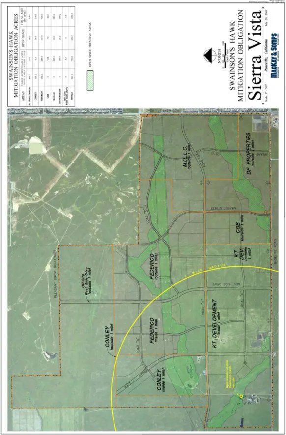
Figure 4.8‐1 shows the locations of on‐site biological communities.
Annual Grasslands
Most of the project area supports disturbed, non‐native annual grassland that has been managed in
different ways. Although most of the project area is currently fallow, there is evidence of former
wheat cultivation, regular disking, and pasture land. Most of the project area has been disked over
the years. During the April 2007 field surveys, the area was dominated by wheat. Large patches of
bare ground and ruderal vegetation such as vetch, turkey mullein, common knotweed, and
bindweed occur throughout the project area. The western portions of the project area appear to
have been historically heavily grazed; however, during the field surveys no cattle were observed on
any portion of the Project area. The areas along the southern Project area boundary appeared to
be recently and regularly disked. All of the fallow areas appear to be dominated by non‐native
grass species such as medusa‐head grass, soft chess, ripgut grass, and slender wild oats. Other
common non‐native herbaceous species include yellow star‐thistle, vetch, filaree, Fitch’s
spikeweed, and virgate tarweed. Native species present include: common fiddleneck, rusty
popcornflower, ookow, white brodiaea, and Ithruriel’s spear.
Non‐native annual grassland habitats generally occupy what was once native grassland consisting
primarily of perennial bunch grasses. Prior to its conversion to agricultural production by settlers,
the Great Valley supported a diversity of habitats made up of vast grasslands, valley oak savannahs,
riparian woodlands, and marshes.
Stream Complex
Curry Creek is a perennial drainage that contained flowing and standing water at the time of the
field surveys. Curry Creek was historically an intermittent stream that has been converted to more
of a perennial condition through the addition of irrigation runoff from upstream development.
FIGURE 4.8‐1
habitat and emergent marsh. The reach of Curry Creek that meanders through the southeastern
corner of the project area between Fiddyment Road and Baseline Road supports a continuous
cattail marsh along nearly its entire course. Small patches of emergent marsh are also present
along the remainder of Curry Creek between Baseline Road and the western boundary of the
project area. Curry Creek supports small, scattered patches of willow‐dominated riparian scrub
occurring in association with the cattail marsh between Fiddyment Road and Baseline Road. The
reach that meanders through the southwest corner supports some scattered willows as well as a
few large Fremont cottonwood trees. The emergent marsh vegetation is largely contained within
the channel of Curry Creek and the willows are scattered and are not continuous enough Two
intermittent tributaries to Curry Creek run east to west across the center of the Project area and the
northern tip (Urban Reserve area) of the site. The tributary in the center of the Project area is
referred to as Federico Creek. These intermittent streams drain into Curry Creek offsite to the
west. They do not support emergent marsh vegetation and were mostly dry during the time of field
surveys in April 2007. A low terrace adjacent to Federico Creek supports relatively deep vernal
pools that appear less disturbed than vernal pools occurring elsewhere within the project area. This
is likely due to the limited disking that has occurred adjacent to the streams.
Strawberry Fields
During field surveys in April 2007, two small portions of the project area supported agricultural
activities. These are the small fields along Baseline Road, which have been planted with
strawberries and are irrigated. One of the fields is at the corner of Baseline Road and Fiddyment
Road, and the other is east of Watt Avenue, north of Curry Creek.
Rural Mix Landscape
A couple of farmsteads are located in the western portion of the project area. These farmsteads
include ornamental tree groves (mostly eucalyptus and other farming and ranching features such as
buildings, barns, and stock ponds. Other than the Fremont cottonwoods and willows along the
streams, the rural mix landscape supports the only trees within the project area. These include
pines, eucalyptus, olive, white mulberry, elm, fig, English walnut and catalpa. The homestead
edges of the rural landscape in the form of tree species such as valley and interior live oaks and
natural wetland features.
Waters of the United States
Over the past five years, several federal jurisdictional delineations were prepared for the various
ownership parcels within the Project and Urban Reserve area. Delineations were completed by
ECORP, Foothill Associates and Gibson & Skordal and all have been subsequently verified by the U.
S. Army Corps of Engineers (USACE)1. A total of 36.434 acres of waters of the United States occur
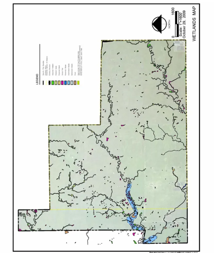
within the Project area. Figure 4.8‐2 indicates the locations of wetlands on the site.
Curry Creek
Curry Creek enters the project area from a culvert under Fiddyment Road approximately 0.5 mile
north of Baseline Road. It meanders through the southeast corner of the project area before
crossing Baseline Road approximately one mile west of Fiddyment Road. It re‐enters the project
area approximately 0.4 mile east of the western boundary and then traverses the project area until
it exits the project area in a northwesterly direction. Much of the water in the creek is likely coming
from urban irrigation and runoff. Other than the scattered riparian vegetation, the banks of Curry
Creek consist of annual grassland. Curry Creek comprises 2.150 acres within the project area.
Anadromous fish species, such as Central Valley spring and winter‐run Chinook salmon and
steelhead, do not occur within Curry Creek, which, as it runs through the Project area, is a small
intermittent drainage corridor. It is shallow and does not contain sufficient depths of water to
support fish for most of the year. Curry Creek supports only resident warm water fish species.
1
Comprehensive Clean Water Act Section 404 Application for Sierra Vista (September 2006)
FIGURE 4.8‐2 WETLANDS MAP
Intermittent Tributaries
Intermittent streams flow during rain events and for a period of time after rain events. Intermittent
streams receive a baseflow contribution from a seasonally perched ground water table and/or
receive surface water from a source that contributes water in the absence of precipitation (e.g.,
irrigation runoff). Intermittent streams typically exhibit defined bed and banks and have an
ordinary high water line. A total of 5.070 acres of intermittent streams occur in the project area. A
small reach of the western portion of Federico Creek was classified as an ephemeral stream
(totaling 0.019 acres in the project area).2 Ephemeral streams typically flow only in response to
direct rainfall and surface runoff, and do not receive baseflow contribution from a seasonal perched
ground water table. They did not convey water during field surveys in April 2007. However, they
did contain small pools of water at several locations throughout their course. These deeper areas
supported native creeping spikerush and fringed water‐plantain. The creek beds support a diversity
of non‐native species and native vernal pool flora, particularly along the upper reach of the tributary
in the central portion of the project area, as described above.
Seasonal Wetland Swales
Seasonal wetland swales are sloping linear wetlands that do not exhibit the bed‐and‐bank
morphology typical of streams. Seasonal wetland swales are scattered throughout the project area
and flow to either Curry Creek or the two tributaries. Most of these features are relatively disturbed
due to regular disking. The seasonal wetland swales along the northern project area boundary
support cultivated wheat and other upland species, along with wetland species such as perennial
rye, Mediterranean barley, creeping spikerush, Vasey’s coyote‐thistle, and iris leaved rush. Less
disturbed wetland swales, such as the wetland swale that flows into the intermittent tributary in the
central portion of the project area, support mostly native vernal pool flora (e.g., double‐horned
downigia, Fremont’s goldfields, stipitate popcornflower, and dwarf wooly‐heads). There are also
substantial stretches of swales without depressions that support a dominance of non‐native species
(perennial rye and Mediterranean barley). A total of 9.879 acres of wetland swales occur in the
project area and 7.749 acres occur within the Urban Reserve.
2
Vernal Pools
Vernal pools are depressional wetlands underlain by hardpans or duripans that pond with winter
and spring rainfall but are dry in the summer and fall. They typically support a variety of
invertebrate populations including federally listed branchiopods and endemic flora. There are
10.654 acres of vernal pools in the project area, and 2.994 acres within the non‐participating Urban
Reserve parcels. Due to past land practices; most of the vernal pools show signs of disturbance.
Species found in these vernal pools include stipitate pop cornflower, Fremont’s goldfields, double‐
horned and Solano downingia, Vasey’s coyote‐thistle, vernal pool buttercup, Pacific foxtail, and
annual hairgrass.
Seasonal wetlands
Seasonal wetlands are seasonally inundated and/or saturated depressions. They are similar to
vernal pools; however, they support mostly a non‐native flora and are not dominated by vernal pool
endemics. Within the project area, these depressions collect rain water or receive water from
baseflow and/or overbank flooding from adjacent stream during high flows. These depressional
seasonal wetlands have been degraded as a result of ongoing disturbance from past farming and/or
disking for fire suppression. Common vegetation within the seasonal wetlands includes curly dock,
perennial rye, spiny‐fruit buttercup, tall flatsedge, Vasey’s coyote thistle, and European
mannagrass. A total of 5.735 acres of seasonal wetlands occur in the project area, and 1.936 occurs
within the Urban Reserve. One wetland originally delineated as emergent marsh (0.859 acre) was
functioning like a seasonal wetland at the time of the field surveys in 2007.
Stock Ponds
There are a few large ponds (totaling 2.067 acres) in the western portion of the project area. They
are associated with farmsteads, with trees and patches of emergent vegetation (cattails, water
plantain, and creeping spikerush) around the perimeter. The ponds were mostly dry at the time of
the field visits in April 2007.
Oak Woodland and Tree Resources
Oak woodland is defined as groups of oak trees that have at least 30 percent canopy cover. Very
few trees occur within the project site, and no oak woodland occurs within the project area. Several
mature cottonwood trees occur along Curry Creek and in other scattered locations. The Arborist
Survey Report (2209) inventoried trees within the Project area.3 In the Project area there are 42
Fremont cottonwood, 18 willow, eight black walnut, five interior live oak, three Oregon ash, and
one valley oak. Three eucalyptus stands are present, each associated with former farmsteads.
In the Urban Reserve area there are a total of 21 Fremont cottonwood trees.
Wildlife Occurrence and Use
The region surrounding the project site is becoming increasingly urbanized with residential
development. The project site is in an area adjacent to this urban expansion, with existing
development to the east and north and proposed development to the south and west.
The project area and surrounding undeveloped landscapes provide suitable habitat for many
wildlife species. During the winter and spring months when vernal pools, swales and other seasonal
wetlands are inundated, these habitats support a variety of aquatic invertebrates including several
special status species, and are key habitats for wintering waterfowl, wading birds, and several
amphibian species such as Pacific chorus frog.
Open grassland provides suitable habitat for several breeding and wintering raptors, particularly for
foraging habitat. Several prey species were detected during surveys including pocket gopher,
meadow vole, and black‐tailed jackrabbit. During the spring and summer seasons, locally breeding
raptors such as Swainson’s hawk, red‐tailed hawk, white‐tailed kite, northern harrier, and American
kestrel are dependent on grassland and agricultural foraging habitats.
During field surveys in April 2007, four red‐tailed hawk nests, one Swainson’s hawk nest, one
possible white‐tailed kite nest, and one great‐horned owl nest were found within the project area or
in adjacent land to the west. Northern harrier and American kestrel were observed foraging in the
3
project area. During the winter, additional species, such a ferruginous hawk, rough‐legged hawk,
Cooper’s hawk and sharp‐shinned hawk, also forage in these landscapes.
Grassland habitats are also important nesting habitat for many ground‐nesting birds, such as
western meadow lark, and horned lark, and are home to several common reptiles such as gopher
snake, valley garter snake, and western fence lizard. The trees and the cattail marsh within Curry
Creek provide suitable nesting opportunities for red‐winged blackbirds and other species that
forage in grassland habitats. The flowing and pooled water provide an important source of drinking
water for many birds and mammals.
The WAPA electric transmission line through the project site provides cover and burrowing habitat
around the tower footings, and perches and nesting opportunities on the towers. During the survey
in April 2007, two red‐tailed hawk nests were identified on the transmission towers.
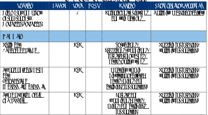
There are 12 plant species and 23 species of animals that either occur or have some potential to
occur within the project area because of the presence of suitable habitat. Table 4.8‐1 lists these
species, their habitat and potential for occurrence within the project area.
Wildlife
Aquatic Invertebrates
Three special status invertebrates potentially occur in seasonal wetland habitats in the project area
vernal pool tadpole shrimp and Conservancy fairy shrimp (both federally listed endangered species)
and vernal pool fairy shrimp (federally threatened). Each of these species occurs in vernal pools
and other seasonal wetland habitats throughout the Central Valley, and each is known to occur or
potentially occurs in western Placer County. There are numerous records of vernal pool fairy
shrimp in southwestern Placer County. There are few records of vernal pool tadpole shrimp. The
Conservancy fairy shrimp was recently detected in western Placer County, which has resulted in an
expansion of the range for this species that includes the Project area. As a result of urbanization,
populations of these species have declined throughout their range. Collectively, these species
occur within a range of specific environmental conditions that include soil type, vegetation
characteristics, water depth, water temperature, inundation duration and water quality.
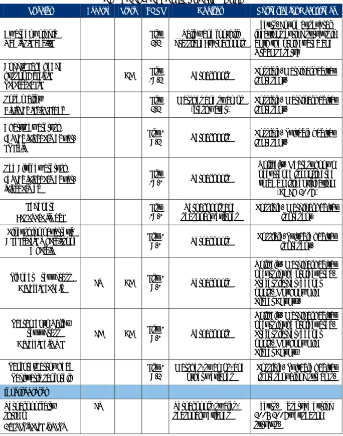
TABLE 4.8‐1
SPECIAL STATUS SPECIES THAT COULD OCCUR IN PROJECT AREA
Species Federal State CNPS Habitat Potential for Occurrence
Plants
Henderson’s bent grass
Agrostis hendersonii
‐ ‐ List
3.2
Valley and foothill grassland; vernal pools
Possible. Marginal habitat is present
Big‐scale balsam‐root
Balsamorhiza macrolepis
var. macrolepis
‐ ‐ List 1
B.2
Cismontane woodland; valley and foothill grassland
Unlikely. Disturbance may preclude this species.
CSC‐ California Species of Special Concern
FE‐ Federally Endangered
FT‐ Federally Threatened
CT‐ California Threatened
CF‐ California Fully Protected
CE‐ California Endangered
CNPS‐ California Native Plant Society
List 1B‐ Rare or Endangered in CA
List 2‐ Rare and Endangered in CA, more
common elsewhere
List .1‐ Seriously endangered in CA
List .2‐ Fairly endangered in CA
*‐ Rookeries are tracked and are of special interest to CDFG
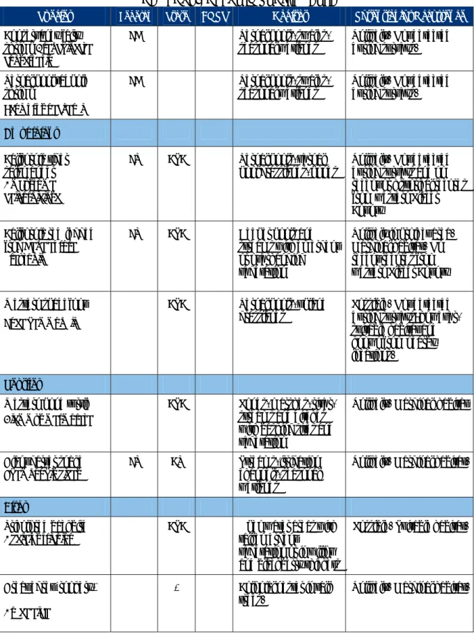
TABLE 4.8‐1 (Continued) SPECIAL STATUS SPECIES THAT COULD OCCUR IN PROJECT AREA
Species Federal State CNPS Habitat Potential for Occurrence
Dwarf downingia
Dowingia pusilla ‐ ‐
List 2.2
Valley and foothill grassland; vernal pools
Occurs. Found at several locations during surveys in both the project area and Urban Reserve
Bogg’s Lake hedge‐ hyssop Gratiola
heterosepala
‐ CE List
1B.2 Vernal pools
Possible. Marginal habitat is present.
Rose mallow
Hibiscus lasiocarpus ‐ ‐
List 2.2
Marshes and swamps (freshwater)
Possible. Marginal habitat is present.
Ahart’s dwarf rush
Juncus leiospermus var.
ahartii
‐ ‐ List 1
B.2 Vernal pools
Possible. Suitable habitat is present.
Red Bluff dwarf rush
Juncus leiospermus var.
leiospermus
‐ ‐ List
1B.1 Vernal pools
Unlikely. Nearest known occurrence is considered to be a misidentification
(CDFG 2007) Legenere
Legenere limosa ‐ ‐
List 1B.1
Vernal pools and seasonal wetlands
Possible. Marginal habitat is present
Pincushion navarretia
Navarretia myersii spp.
Myersii
‐ ‐ List 1
B.1 Vernal pools
Possible. Suitable habitat is present.
Slender Orcut grass
Orcuttia tenuis FT CE
List 1
B.1 Vernal pools
Unlikely. Marginal habitat occurs in the project area. Prefers larger, deeper pools. Not known in Placer County. Sacramento Valley
Orcutt grass
Orcuttia viscida
FE CE List 1
B.1 Vernal pools
Unlikely. Marginal habitat occurs in the project area. Prefers larger, deeper pools. Not known in Placer County Sanford’s arrowhead
Sagittaria sanfordii ‐ ‐‐
List 1 B.2
Marshes, swamps, and other wetlands
Possible. Suitable habitat is present along streams.
Invertebrates
Vernal pool fairy shrimp
Branchinecta lynchi
FT ‐ ‐ Vernal pools, swales, seasonal wetlands
Occurs. Observed during 2005‐2007 wet season surveys.
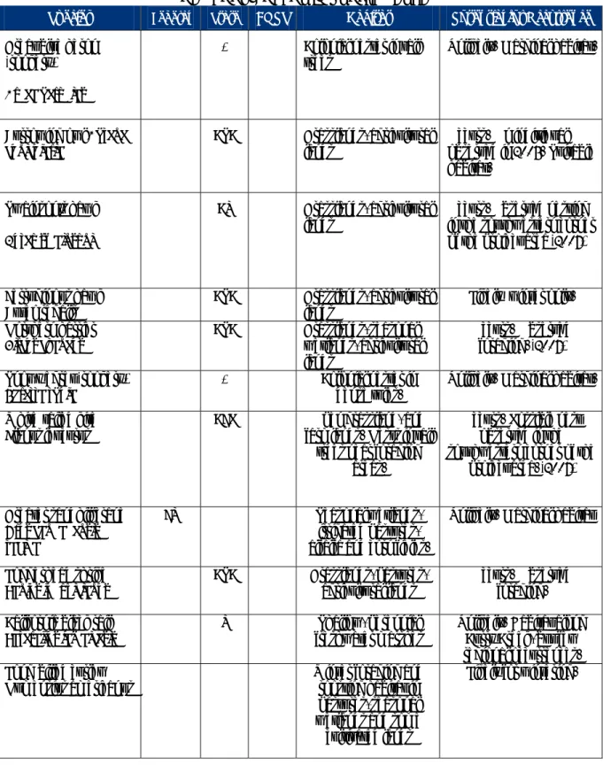
TABLE 4.8‐1 (Continued) SPECIAL STATUS SPECIES THAT COULD OCCUR IN PROJECT AREA
Species Federal State CNPS Habitat Potential for Occurrence
Conservancy fairy shrimp Branchinecta
conservatio
FE ‐ ‐ Vernal pools, swales, seasonal wetlands
Unlikely. Not detected during surveys. Vernal pool tadpole
shrimp
Lepidurus packardi
FE ‐ ‐ Vernal pools, swales, seasonal wetlands
Unlikely. Not detected during surveys.
Amphibians
California tiger salamander
Ambystoma
californieinse
FT CSC ‐ Vernal pools, vernal pool grasslands, ponds
Unlikely. Not detected during surveys and no recent or historical records from western Placer County
California red‐legged
frog Rana aurora
draytonii
FT CSC ‐ Deeper pools and streams with emergent or overhanging vegetation
Unlikely in project area. Marginal habitat. No recent records from western Placer County Western spadefoot
Spea hammondii
‐ CSC ‐ Vernal pools, upland grasslands
Possible. Not detected during surveys; however, suitable habitat and known from nearby locations.
Reptiles
Western pond turtle
Clemmys marmorata
‐ CSC ‐ Ponds, marshes, river, streams and ditches with basking sites and vegetation
Unlikely. Marginal habitat
Giant garter snake
Thamnophis gigas
FT CT ‐ Streams, irrigation channels, seasonal wetlands
Unlikely. Marginal habitat.
Birds
Tricolored backbird
Agelaius tricolor
‐ CSC ‐ Open water areas with tall emergent
vegetation or in willow and blackberry thickets
Possible. Suitable habitat.
Great egret (rookery)
Ardea alba
‐ * ‐ Colonial nester in tall trees.
TABLE 4.8‐1 (Continued) SPECIAL STATUS SPECIES THAT COULD OCCUR IN PROJECT AREA
Species Federal State CNPS Habitat Potential for Occurrence
Great blue heron (rookery)
Ardea herodias
‐ * ‐ Colonial nester in tall trees
Unlikely. Marginal habitat.
Burrowing owl Ahtene
cunicularia
‐ CSC ‐ Grasslands, agricultural lands
Occurs. On individual observed in 2005. Suitable habitat.
Swainson’s hawk
Buteo swainsoni
‐ CT ‐ Grasslands, agricultural lands
Occurs. Observed nesting in the southwestern corner of the project area (2007)
Ferruginous hawk Buteo regalis
‐ CSC ‐ Grasslands, agricultural lands
Likely‐ winter only. Northern harrier
Circus cyaneus
‐ CSC ‐ Grasslands, seasonal wetlands, agricultural lands
Occurs. Observed foraging. (2007) Snowy egret (rookery)
Egretta thula
‐ * ‐ Colonial nester in dense tules.
Unlikely. Marginal habitat. White‐tailed kite
Elanus leucurus
‐ CFP ‐ Open grassland, and farmlands. Nests in tall
trees near foraging areas.
Occurs. Possible nest observed in the southwestern corner of the
project area. (2007)
Greater sandhill crane
Grus candadensis
tabida
FT ‐ ‐ Seasonal wetlands, irrigated pastures, alfalfa and corn fields.
Unlikely. Marginal habitat
Loggerhead shrike
Lanius ludovicianus
‐ CSC ‐ Grasslands, pastures, agricultural lands
Occurs. Observed foraging. California black rail
Laterallus jamaicesis
‐ T ‐ Shallow, perennial freshwater marshes
Unlikely. Habitat along Curry Creek, but few regional occurrences. Long‐billed curlew
Numensius americanus
‐ ‐ ‐ Winter foraging and roosting habitat in pastures, seasonal wetlands and some
cultivated lands
TABLE 4.8‐1 (Continued) SPECIAL STATUS SPECIES THAT COULD OCCUR IN PROJECT AREA
Species Federal State CNPS Habitat Potential for Occurrence
Black‐crowned night‐ heron (rookery)
Nycticorax nycticorax
‐ * ‐ Colonial nester in trees and tule patches
Unlikely. Marginal habitat.
Mammals
Pallid bat
Antrozous pallidus
‐ CSC ‐ Shrublands, grasslands, woodlands,
forests; rocky areas, caves, hollow trees
Possible for foraging, unlikely for roosting.
Twonsend’s big‐eared bat
Corynorhinus
twonsendii twonsendii
‐ CSC ‐ Most low to mid‐
elevation habitats; caves, mines, and buildings for roosting.
Possible for foraging, unlikely for roosting.
Yuma myotis Myotis
yumanensis
‐ CSC ‐ Forests and woodlands; caves, mines, and buildings
for roosting
Possible for foraging, unlikely for roosting.
In general, vernal pool and seasonal wetland habitats that meet the general definition of habitat are
considered suitable habitat by these species.
ECORP conducted wet season surveys for listed branchiopod, completing the second year of the
two wet season surveys in 2006‐2007. Where one of the listed branchiopods were found within a
watershed, it was assumed that that all suitable habitat within that watershed was occupied and no
further sampling was conducted in that watershed. Where listed branchiopods were not found,
sampling continued through the second wet season. As a result, those watersheds where listed
branchiopods were not found were subject to two full wet season protocol surveys. Of the 432
pools sampled during the 2005‐2006 season, four were found to be occupied by vernal pool fairy
shrimp. During 2006‐2007 surveys, vernal pool fairy shrimp were found in two additional locations,
for a total of five watersheds within the project area. Two of the watersheds are entirely within the
Urban Reserve area, and one is entirely within the project area. The remaining two watersheds
cover portions of both the Urban Reserve and project area. These occupied watersheds encompass
4.216 acres of vernal pool fairy shrimp habitat in the project area, and 3.826 acres of habitat in the
Neither the vernal pool tadpole shrimp nor the Conservancy fairy shrimp were detected during
these surveys. Each species has a very restricted known distribution in western Placer County
compared with the vernal pool fairy shrimp. Thus, while these species could potentially occur, they
are considered unlikely to occur in the project area.
California tiger salamander is a federally threatened species and a state species of special concern.
It can be found in vernal pools and seasonal ponds, including stock ponds, in grassland, from sea
level to about 1,500 feet in central California. No known tiger salamanders occur in the project
vicinity. No specific surveys were conducted for the salamander. The species was not detected
during extensive vernal pool and seasonal wetland surveys for listed branchiopods and western
spadefoot. Thus, it is unlikely that the species occurs in the project area.
California red‐legged frog is a federally listed threatened species and is designated as a state
species of special concern. Once common, most of the remaining populations occur in the Coast
Ranges. The nearest known occurrence in Placer County is at Michigan Bluff, approximately 50
miles northeast of the project site, a considerable distance away. No red‐legged frogs have been
found in the project vicinity. Although Curry Creek provides potential habitat, bullfrogs are
predators of the California red‐legged frog (CRLF), and were detected within Curry Creek which
makes it unlikely that the CRLF is present within the project area. There is no potential habitat
within the Urban Reserve areas.
Western spadefoot toad is a state species of special concern. It occurs throughout the Central
Valley and adjacent foothills up to 4,500 feet. The American spadefoot toads are of typical shape to
most burrowing frogs. They are round, with short legs and protruding eyes. As suggested by their
name, this frog has hard, keratinous protrusion present on their feet, which helps them to dig. Like
most burrowing frogs, they will dig backwards into the ground.
ECORP indicate that there are four occurrences within five miles of the project. All of the recorded
sites have likely been disturbed or are threatened due to past and ongoing urbanization in the
Roseville area. While the project area contains suitable habitat for the spadefoot, species‐specific
surveys conducted by ECORP in 2006 and 2007 on the majority of the project area did not detect
the species within the project area. Surveys for the Baybrook property and the Chan property were
Giant garter snake is a state and federally listed threatened species. The Natomas Basin contains
the nearest known occurrence, approximately five miles to the west. While the Project area is not
within the known current distribution of giant garter snake, Curry Creek is hydrologically connected
to the Natomas Basin. The project area supports marginally suitable habitat for the snake. Thus
while occurrence is unlikely, there remains the potential for occurrence within the Project area.
Greater sandhill crane is a state listed threatened species. Portions of the Sacramento‐San
Joaquin Delta and Cosumnes River basin are principal wintering grounds for the crane. Most
traditional foraging areas are near communal roost sites (within 2‐3 miles) that are flooded with
several inches of standing or slowly moving water. Foraging habitat includes harvested fields,
irrigated pastures, alfalfa fields and seasonally flooded habitats. The potential for occurrence in the
Project area is considered low.
Northern harrier is a state species of special concern. While population declines in California have
been noted for many years, the species can be locally abundant. They occur primarily in open
wetland, grassland, and agricultural habitats. The northern harrier is a ground‐nesting raptor,
which nests on the ground in marsh, grassland, and some agricultural habitats, particularly grain
fields. They forage in seasonal wetland, grassland, and agricultural habitats. Several adult
northern harriers were observed foraging in the project area during the survey. The cattail marsh
and associated seasonal wetland habitats along Curry Creek, particularly in the eastern portion of
the project area, provide suitable nesting habitat for this species. No nests were observed at the
time of the survey.
White‐tailed kite is a state species of special concern and a state fully protected species. The
white‐tailed kite nests in riparian forests and woodlands, and occasionally in isolated trees. They
forage in grasslands, seasonal wetlands, and agricultural fields.
A possible white‐tailed kite nest was observed in a locust tree along Curry Creek in the
southwestern corner of the project area. An adult kite was observed exhibiting defensive behavior;
however, the nest was positioned such that no activity could be discerned. Due to the presence of
the kite and its behavior, nesting activity is highly probable in the project area. The project area
Swainson’s hawk is a state listed threatened species. It forages in open grassland in the Central
Valley and Great Basin and nests in riparian forests, remnant oak woodlands, isolated trees, and
roadside trees. They forage primarily in agricultural habitats, particularly those that optimize
availability of prey, and also use irrigated pastures, and annual grasslands. The scattered valley
oak, cottonwood, willow, and eucalyptus trees located in the project area provide suitable nesting
opportunities.
One Swainson’s hawk nest was observed in the southwestern corner of the project area during
surveys in April 2007. It is located in a eucalyptus tree on the north side of the farmstead.
Numerous nest sites are known to occur in the vicinity of the project area. The entire project site is
considered suitable foraging habitat for the Swainson’s hawk.
Ferruginous hawk is designated as a state species of special concern. It typically does not nest in
California. Individuals migrate into California during the winter where they utilize open grassland
and agricultural land for foraging and roosting. The project site provides suitable grassland
wintering habitat for this species. While it probably is only an occasional visitor, its potential for
occurrence during the winter is high.
California black rail is a state‐listed threatened species. Until recently, the current range of this
species was thought to be restricted mainly to coastal marshes. In the 1990’s populations were
discovered in freshwater marshes in Yuba County. Recently the black rail was detected in the City
of Rocklin in Clover Valley and along Yankee Slough southeast of Sheridan. The black rail typically
inhabits marshes dominated by bulrushes and cattails. A relatively narrow range of conditions is
required for occupancy and successful breeding. Too much water will prevent nesting and too little
water will lead to abandonment of the site. Because of its continuing range expansion, it is possible
that it might occupy the emergent marsh of the project site.
Long‐billed curlew, until recently, was a state species of special concern. The population was
significantly reduced at the end of the 19th century by hunting. Numbers have rebounded
sufficiently in more recent times, so that it no longer is a state species of special concern. The
species is not included on the recent revision to this list. While none were reported during surveys,
grasslands are suitable foraging and roosting habitat for this species, which is fairly wide‐ranging
during the winter season.
Western burrowing owl is a state species of special concern. It is a small ground‐dwelling owl,
typically occupying the burrows created by ground squirrels. They also occupy artificial habitats,
such as those created by pipes and small culverts. Burrowing owls forage in grassland and
agricultural habitats with low vegetative height.
No burrowing owls or active burrows were detected during the most recent field survey. ECORP
recorded a burrowing owl occupying a debris pile in the project area during October 2005. It was
not observed during subsequent surveys by ECORP in 2006. The nearest recorded burrowing owl
site is approximately one mile north of the project area, and has presumably been displaced as a
result of the development of the West Roseville Specific Plan.
An evaluation of the habitat during the April 2007 field surveys determined that the SVSP had
relatively little ground squirrel activity and thus few potential nesting opportunities for burrowing
owl. The entire project area is otherwise considered suitable for burrowing owls and is likely
occasionally used for foraging.
Tri‐colored blackbird is a state species of special concern and more than 99% of the global
population occurs in the state. In any given year, more than 75% of the breeding population can be
found in the Central Valley. They breed in colonies that require the following: open accessible
water; a protected nesting area including either flooded or thorny or spiny vegetation; and a
suitable foraging space providing adequate insect prey within a few miles of the nesting colony.
The tri‐colored blackbird was not observed during the field survey. However, the cattail marsh
along Curry Creek in the southeastern portion of the project area provides potential nesting
habitat, and the surrounding grasslands provide suitable foraging habitat. The nearest known
reported occurrence is in Lincoln.
Loggerhead shrike is a species of special concern. It is a permanent resident and winter visitor
throughout California. They prefer open habitats with scattered trees, shrubs, posts, fences, utility
lands. One loggerhead shrike was observed during the field survey in April 2007. No nests were
Heron/Egret Rookeries
Rookeries are colonial nesting sites for heron and egret species. While these species are not
considered special status species, rookeries are included on the CDFG’s special animals list because
these breeding colonies can support a large segment of local populations. There are currently no
rookeries in the project area. The eucalyptus groves may provide potential rookery sites for all of
these species, and the cattail marsh associated with Curry Creek may provide potential breeding
habitat for black‐crowned night heron and snowy egret. However, these species typically nest in
association with marshes and irrigated pasture land or irrigated crop land that provides a greater
source of food than do the un‐irrigated pasture lands in the project area. Thus the occurrence of a
rookery onsite is considered unlikely.
4.8.3 REGULATORY
SETTING
Federal
The U.S. Fish and Wildlife Service (USFWS) administers the Federal Endangered Species Act (FESA)
except for anadromous fish species and other salt water species. Projects that would result in
“take” of any federally listed threatened or endangered species are required to obtain authorization
from the USFWS through either Section 7 (Interagency Consultation) or Section 10 (a) (incidental
take permit) of FESA, depending on whether the federal government is involved in permitting or
funding the project. The authorization process, be it through Section 10 or Section 7, is used to
determine whether a project would jeopardize the continued existence of a listed species or cause
the destruction or adverse modification of designated critical habitat for the species, and what
mitigation measures would be required to avoid jeopardizing the listed species and/or minimize
incidental take of the listed species.
“Take” under the federal definition means to harass, harm, pursue, hunt, shoot, wound, kill, trap,
capture, or collect, or to attempt to engage in any such conduct. Incidental take is defined as a take of listed fish or wildlife that results from, but is not the purpose of, carrying out an otherwise lawful
activity conducted by a federal agency or private party. Section 10 (a) (1) (B) requires an applicant
for an incidental take permit to submit a “conservation plan that specifies, among other things, the
undertake to minimize and mitigate such impacts.” Where Section 7 is involved, incidental take
authorization is provided by the incidental take statement included in the Biological Opinion.
City/U.S. Fish and Wildlife Service MOU
In August 2000, the City and the USFWS entered into a memorandum of understanding (MOU) to
prepare a Habitat Conservation Plan (HCP) or equivalent permit process to minimize the indirect
impact and incidental take of vernal pool species from future City growth. Co Consistent with this
agreement, the City of Roseville, the SVSP Landowners, and the USFWS, the USACE, and the U.S.
Environmental Protection Agency (EPA) conducted an extensive early consultation process. The
group met on 14 different occasions between March 2007 and August 2008 with the following
objective: to reach basic agreement on a land use plan and mitigation strategy that could be
permitted under Section 404 of the Clean Water Act utilizing a Section 7 Consultation process for
ESA compliance. Modifications to the proposed land use plan were made based on feedback
received, which resulted in additional avoidance areas.
Vernal Pool Recovery Plan
The SVSP is located within the area covered by the “Recovery Plan for Vernal Pool Ecosystems of
California and Southern Oregon” (December 15, 2005), also referred to as the Vernal Pool Recovery
Plan. According to the preface, such plans are voluntary guidance documents, not regulatory
documents, which broadly address conservation needs of the species. Recovery plans are
necessarily expansive, identifying many options and strategies that may contribute to recovery.
According to the Vernal Pool Recovery Plan, "no agency or other entity is required by the
Endangered Species Act to implement the recovery strategy or specific recommended action in a
recovery plan," (page J‐2), and that recovery plans are also "not land use plans and cannot restrict activities proposed by other agencies or the public." (Page J‐4).
A recovery plan neither expands nor contracts any obligations under the ESA. Whether or not the
USFWS has adopted a recovery plan, all persons are subject to the prohibitions against take of a
listed species in Section 9 of the ESA, and all federal agencies must comply with the requirement
under Section 7 of the ESA to ensure that its actions do not jeopardize the continued existence of a
Migratory Bird Treaty Act of 1918 (MBTA)
The MBTA makes it “unlawful to take any migratory bird listed in 50 CFR Part 10, including nests,
eggs, or products”. This regulation is pertinent to any shrub or tree removal required for a
proposed project, or project‐related disturbance that could affect nesting migratory birds. The
MBTA could require that elements of the proposed project (particularly vegetation removal) be
reduced or eliminated during critical phases of the nesting cycle unless surveys by a qualified
biologist demonstrate that nests, eggs, or nesting birds will not be disturbed. Disturbance that
cases nest abandonment and/or loss of reproductive effort (killing or abandonment of eggs or
young) is considered “taking”.
Clean Water Act
The objective of the Clean Water Act (CWA) is to restore and maintain the chemical, physical, and
biological integrity of the Waters of the United States. Section 401 prohibits the discharge of any
pollutant into the Waters of the United States without certification that the discharge would not
violate applicable water quality standards, and Section 402 establishes the National Pollutant
Discharge Elimination System (NPDES) permit program, which regulates “point sources” of water
pollution. Section 404 of the Act requires a USACE permit for discharges of dredged or fill
materials into waters of the United States (as defined in the Code of Federal Regulations (33 CFR
Section 328.3 [a]; 40 CFR Section 230.3 [s]). Section 404 of the CWA is administered by the USACE.
State
California Endangered Species Act (CESA)
The California Department of Fish and Game (CDFG) administer a number of laws and programs
designed to protect biological resources. CESA regulates the listing and take of state‐endangered
(SE) and state‐threatened (ST) species. CESA establishes that it is the policy of the State of
California to conserve, protect, restore, and enhance endangered species and their habitats.
Species listed under CESA cannot be taken without adequate mitigation and compensation. The
definition of take under CESA is narrower than that described under FESA, as the state definition
does not include “harm” or “harass.” Rather, Fish and Game Code Section 86 defines “take” to
Typically, the CDFG implements endangered species protection and take determinations through
the issuance of incidental take permits pursuant to Fish and Game Code Section 2081. Species
listed under CESA cannot be “taken” without mitigation and compensation.
California candidate species are given protection that is equal to that provided to listed species. In
addition, separate and apart from CESA, CDFG also identifies what it calls Species of Special
Concern (CSC) based on limited distribution, declining populations, diminishing habitat, and/or
unusual scientific, recreational, or educational value. These species are not afforded the same legal
protection as listed species, but may be added to official lists in the future. The designation of CSC
is intended by the CDFG as a management tool for consideration in future land use decisions. As a
consequence, the CDFG typically requests that CEQA lead agencies give consideration to
minimization of impacts to CSC species when approving projects.
Natural Communities Conservation Planning Act
Sections 2800–2835 of the California Fish and Game Code detail the State’s policies on the
conservation, protection, restoration, and enhancement of the State’s natural resources and
ecosystems. The intent of the legislation is to provide for conservation planning as an officially
recognized policy that can be used as a tool to eliminate conflicts between the protection of the
State’s natural resources and the need for growth and development. In addition, the legislation
promotes conservation planning as a means of coordination and cooperation among private
interests, agencies, and landowners, and as a mechanism for multi‐species and multi‐habitat
management and conservation. A Natural Communities Conservation Plan (NCCP) can be an
alternative to an incidental take permit issued under CESA as a source of take authorization for
state‐listed species.
Fully Protected Species Four sections of the California Fish and Game Code ( Sections 3511 [birds],
4700 [mammals], 5050 [reptiles and amphibians], and 5515 [fish]) list 37 fully protected species.
CESA prohibits take or possession at any time of fully protected species. CDFG is unable to
authorize incidental take of fully protected species when activities are proposed in areas inhabited
by those species. CDFG has informed nonfederal agencies and private parties that they must avoid
Protection of Bird Nests and Raptors
Section 3503 of the California Fish and Game Code states that it is unlawful to take, possess, or
needlessly destroy the nest or eggs of any bird. Section 3503.5 specifically states that it is unlawful
to take, possess, or destroy any raptors (i.e. hawks, owls, eagles, and falcons), including their nests
or eggs. Typical violations involve removal of vegetation in which nests are located resulting in
destruction of active nests. Violation of Section 3503.5 could also involve failure of active raptor
nests resulting from disturbance of nesting pairs by nearby project construction.
Sections 3511 and 3503.5 of the Fish and Game Code
The CDFG derives its authority from the Fish and Game Code of California. Species listed under
CESA cannot be “taken” without mitigation and compensation.
Sections 1600‐1607 of the Fish and Game Code
Under Section 1600‐1607 of the California Fish and Game Code, CDFG regulates activities that
would substantially alter the flow, bed, channel, or bank of streams and lakes. The lateral limits of
CDFG’s jurisdiction are defined in the statute as the bed, channel, or bank of any river, stream, or lake designated by CDFG in which there is at any time an existing fish or wildlife resource or from
which these resources derive benefit…” In practice, CDFG usually determines its lateral limit of
jurisdiction to be the top of bank or the outer edge of the riparian vegetation, whichever is farther
from the middle of the water body in question.
State Water Resources Control Board
The State Water Resources Control Board administers Section 401 of the Clean Water Act. Section
401 of the CWA requires that an applicant for a Section 404 permit must first obtain a certification,
or a waiver thereof, that the project will not violate applicable state water quality standards. In
California, the authority to either grant certification or waive the requirement for certification has
been delegated by the State Water Resources Control Board to the nine regional boards, including,
in the Roseville area, the Central Valley Regional Water Quality Control Board. A request for
certification or waiver is typically, but not is not required to be submitted to the regional board at
the same time that the Section 404 application is filed with the USACE. The regional board has 60
permit is valid under the CWA unless “certified” by the state, the regional boards may effectively
veto or add conditions to any USACE permit.
Additionally, implementation of the State Water Resources Control Board NPDES General Permit
for Storm Water Discharges Associated With Construction and Land Disturbance Activities
(“General Permit”) would reduce impacts associated with erosion and runoff from construction
sites. As described in more detail in Section 4.13, Hydrology and Water Quality (see subsection
4.13.3 and Impact 4.13‐4), for any construction that would disturb one or more acres of land, the
“discharger” must obtain coverage under the General Permit. In order to obtain coverage under
the General Permit, the discharger must undertake a risk assessment, develop a Storm Water
Pollution Prevention Plan (SWPPP), implement Best Management Practices (BMPs) in accordance
with the SWPPP, and comply with monitoring and reporting requirements and other management
practices to prevent or reduce pollution.
Local
Placer County Conservation Plan (PCCP)
For the past several years, Placer County has been working with regulatory agencies and
stakeholders to prepare a Natural Community Conservation Plan and Habitat Conservation Plan
(NCCP/HCP) to address the conservation of natural communities, endangered species and other
less sensitive species of native wildlife that could be affected by actions in the County and other
participating agencies such as the Placer County Water Agency (PCWA) and the City of Lincoln. As
part of the process, the County intends to apply for a Clean Water Act Section 404 Programmatic
General Permit (PGP), CDFG Master Streambed Alteration Agreement (MSAA) and Clean Water
Act Section 401 Water Quality Certification. Collectively, the NCCP, HCP, PGP, MSAA, and Water
Quality Certification application have been termed the Placer County Conservation Plan (PCCP). At
this time the County is focusing on Phase 1, which addresses lands within western Placer County
(lands west of Auburn to the western county line). Listed species that are presumed to be covered
by such a plan include but are not limited to: Swainson’s hawk, vernal pool fairy shrimp, vernal pool
tadpole shrimp, and several listed fish species. The City of Roseville is currently not participating in
the PCCP because of the City’s existing MOU with the USFWS. Uses and mitigation proposed as
Placer Legacy Open Space and Agricultural Conservation Program
The Placer Legacy program, in conjunction with resource agencies and local stakeholders, is
intended to protect and conserve open space and agricultural lands in Placer County. A key
element of the program is to enable the County to make itself a willing buyer to persons wishing to
sell interest in lands having value for conservation purposes.
City of Roseville
City of Roseville Design and Construction Standards
Implementation of Section 111 of the City’s Construction Standards would reduce impacts
associated with erosion and runoff from construction sites containing soil or other materials that
could degrade water quality if discharged to local streams and changes in surface water or
groundwater quality from storm water runoff by requiring the development of an Erosion Control
Plan. The erosion control plan would include a description of the site, time restrictions, erosion and
sediment controls to be used, means of waste disposal, control of post‐construction sediment,
erosion control measures, maintenance responsibilities, landscaping during and after grading, and
non‐storm water management controls.
Further Section 111.6 of the Construction Standards contains the following specifications for
grading adjacent to wetlands:
Grading activities adjacent to sensitive wetland or creek areas shall be conducted under the
conditions set forth under the Grading Permit. These conditions shall also include:
1. Prior to construction within any phase of the project, high visibility temporary construction
fencing shall be installed along the parcel adjacent to the preserve or creek. Fencing shall
be maintained daily until permanent fencing is installed, at which time the temporary
fencing shall be removed from the project site.
2. With the exception of access required for maintenance and/or emergency vehicles, the
project shall be designed to prevent vehicle access into the Open Space Preserve. Post and
3. Landscaping adjacent to the Open Space Preserve shall be California native, drought‐
tolerant groundcover, shrubs, plants and trees.
4. The Pre‐Construction meeting shall address the presence of the Open Space Preserve, the
sensitive habitats present and minimization of disturbance to the Open Space Preserve.
During grading and construction the preserve area shall be avoided and shall not be used
for parking, storage, or project staging. The contractor shall remove all trash blown into
the preserve from adjacent construction on a daily basis. After construction is complete,
the temporary fencing shall be removed from the preserve, along with all temporary
erosion control measures.
City of Roseville Zoning Ordinance‐Tree Preservation (Chapter 19.66)
The City of Roseville Tree Preservation Ordinance protects native oak trees 6‐inches or more in
diameter at breast height (dbh) and specific landmark trees. As specified below, the ordinance
requires a permit for any activity that would harm, destroy, kill or remove any protected tree. In
addition to removal, grading (cut or fill) and trenching within the dripline are subject to permit
approval.
19.66.030 Tree Permits. Permit required. No person shall conduct any regulated activities within
the protected zone of any protected tree; or harm, destroy, kill or remove any protected tree unless
authorized by a tree permit.
B. Type of Permit.
1. Administrative Tree Permit. An administrative tree permit is required for any regulated activity
affecting one or more protected trees, when the regulated activity is not associated with a
discretionary project, does not include the removal of a protected tree, and the requested
encroachment does not exceed 20 percent of the projected zone of any individual protected tree.
2. Tree Permit. A tree permit is required for any regulated activity within the protected zone of a
protected tree where the encroachment exceeds 20 percent of the protected zone, or where the
regulated activity is related to a discretionary project. In addition, a tree permit is required for the