M anagement of the Edwards Aquifer Region:
How the Endangered Species Act influenced Action
Glenn Longley
Director, Edwards Aquifer Research & Data Center Southwest Texas State University, San Marcos, Texas
and
Wayne R. Jordan
Director, Texas Water Resources Institute Texas A & M University, College Station, Texas
INTRODUCTION
The Edwards Aquifer (EA) located in southwest Texas is a component of an extensive hydrologic system originating with a large contributing area in the Edwards plateau and terminating as fresh water inflows into bays and estuaries on the state’s Gulf coast. Details of the surface and groundwater systems of the region are presented elsewhere in this issue by Grubb (1997). Historically, most concerns about the EA centered on its ability to continue to provide adequate quantities of high quality water for irrigation, recreation, municipal and industrial supplies, and springflows, which, in turn, provide for instream flows to satisfy downstream water rights and maintain productivity of bays and estuaries. Less well known and appreciated is the unique biological community that exists in and is supported by natural springflows from the EA (Longley 1981, 1992). Members of this community reside within the underground channel/cave system of the karstic aquifer, in the shallow lakes above spring openings and in the streams fed by flows from springs in those lakes and the stream beds. The community includes 4 endangered and 1 threatened species, but a host of other vertebrate and invertebrate organisms are present and may be unique to the EA. (Longley 1978 and Langecker and Longley 1993).
The ongoing drought has again drawn attention to the need for a plan that provides for protection of the needs of various stakeholders in the use of water from the EA, and a management structure empowered to implement the plan. Public demand for such a plan and management entity, coupled with recent failures to achieve voluntary solutions among stakeholders, resulted in a spate of judicial and legislative activities described by Schenkkan (1997) elsewhere in this issue.
The paper focuses on the likely impacts of proposed management alternatives on the biological community supported by spring flows from the EA. Since little information is available to establish impacts of potential changes in water quality on the species present, emphasis will be placed on maintenance of quantities of water available for spring flows as the principal criterion to ensure protection of both habitat and numbers and diversity of species present.
BACKGROUND
Withdrawals of water by wells (pumpage) rose from about 102,000 acre-feet (af) in 1934 to over 542,000 af in 1989 as shown in Figure 1.
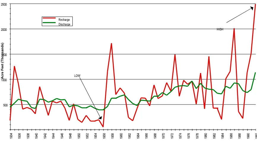
Spring discharges reflect the resultant balance between pumpage and recharge, integrated through the effect of both on pressure in the artesian zone. A measure of the pressure at San Antonio is the elevation of water in well J-17, used as an index well because of its long measurement record. The historic high elevation of 703.3 feet above mean sea level (msl) was recorded in 1992, while the historic low of 612.5 msl occurred in 1956 near the end of the so-called ‘drought of record’ for the region. The long term average elevation of J-17 is 664 msl. Figure 2 illustrates the longterm relationship between recharge and discharge.
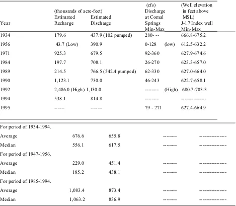
Table 1. Selected hydrologic information about the Edwards Aquifer in the San Antonio region (EUWD, 1993; EUWD, 1995; and USGS records).
(cfs) (Well elevation (thousands of acre-feet) Discharge in feet above
Estimated Estimated at Comal MSL)
Year Recharge Discharge Springs J-17 Index well
Min-Max Min-Max
1934 179.6 437.9 (102 pumped) 280- -- 666.8-675.2
1956 43.7 (Low) 390.9 0-128 (low) 612.5-632.2
1971 925.3 679.5 92-360 627.9-674.6
1984 197.7 708.1 26-270 623.3-657.0
1989 214.5 766.5 (542.4 pumped) 62-330 627.0-664.0
1990 1,123.1 730.0 46-243 622.7-658.1
1992 2,486.0 (High) 1,130.0 --- (High) 680.7-703.3
1994 538.1 814.8 ---
---1995 --- --- 79 - 271 627.4-664.9
For period of 1934-1994.
Average 676.6 655.8 ---
---Median 556.1 617.5 ---
---For period of 1947-1956.
Average 229.0 451.4 ---
---Median 185.2 438.1 ---
---For period of 1985-1994.
Average 1,083.4 873.4 ---
---Median 1,063.2 836.9 ---
---flows at Comal Springs were greatly reduced after shorter, less intense droughts than occurred during the 1950s, illustrating the precarious nature of the biological community depending upon continuous spring flows. The relation between water elevation in well J-17 and flows from Comal Springs is illustrated in Figure 3. The correlation to flows at San Marcos Springs is much lower due to the greater distance from San Antonio and the influence of recharge from the Blanco River basin.
1,063.2 af. The use of median instead of average values leads to more realistic numbers for planning, since outliers are given less weight. By comparing the high year of 1992 with 1995, it becomes obvious that aquifer levels now can drop quickly over a much shorter period of time, in a less intense drought. It is not uncommon for levels in the San Antonio Index well (J-17) to drop on the average of 1-2 feet per day during the peak water use season. This indicates that much greater use is being made of the aquifer today than in the past. If the present trend continues unabated, a point will soon be reached where all springs discharging from the aquifer will become intermittent at first, and then later will be dry most of the time.
Since recharge and withdrawals vary both spatially and temporally within the aquifer, an understanding of the dynamics of the hydrologic system is essential for the success of any plan to protect its many, varied uses. During a recurrence of the drought of record, existing hydrologic models suggest pumpage must be reduced to no more than 200,000 af per year to assure flows from both springs. Since pumpage in 1989, a dry year, was estimated at over 540,000 af, a reduction to 200,000 af would be accompanied by major economic impacts in the agricultural, municipal and industrial sectors. Given the likely magnitude of these economic impacts, it is not surprising that attempts to reach a consensus on voluntary actions necessary to protect spring flows have been unsuccessful.
TEXAS WATER LAW AND AQUIFER MANAGEMENT
The laws governing use and protection of water in Texas are discussed in detail by Schenkkan (1997) elsewhere in this issue. To summarize, surface water is held in public trust by the state and allocated to users through a system of water rights. Groundwater is subject to the rule of capture (better known as the law of the biggest pump!) with few restrictions and is jealously guarded as a private property right. Landowners may freely pump water from beneath their property so long as it is put to beneficial use.
Separate treatment of surface and ground water by the Texas Water Code has resulted in formation of a host of public institutions with authority to use, withdraw or otherwise manage isolated parts of the tightly interconnected hydrologic system. Examples are river authorities, underground water conservation districts and municipal and rural water supply corporations. These institutions, separately or collectively, do not have the authority to implement an integrated water management plan for the Edwards Aquifer. The need for a new type of management entity, with authority to manage both surface and ground water resources has been recognized for many years. The impetus for the state legislature to act to form such an entity was provided by a recent lawsuit filed under provisions of the Endangered Species Act (ESA). Legal authorities under the ESA as they pertain to the Edwards Aquifer are discussed by Schenkkan (1997) and summarized by Smith and Vaughn (1996). Outcomes from this suit include formation of the Edwards Aquifer Authority (EAA) and development and implementation of a number of plans related to recovery of endangered species and related ecosystems of Comal and San Marcos Springs.
THE ENDANGERED SPECIES ACT
Federal authority to identify, protect and aid in the recovery of endangered and threatened species is defined under PL 93-205 better known as the Endangered Species Act of 1973. The ESA further provides that actions that result in take or jeopardy of a listed species constitutes a violation of the Act, except where such take is the result of a legal activity (ESA Amendment, 1982). Withdrawals from the aquifer that threaten spring flow at Comal and San Marcos Springs can be considered take if the resulting diminished flows lead to harm of any individuals of the listed species. A more serious condition termed jeopardy occurs when the entire population of the species is in peril as may happen if spring flows cease or decrease to very low levels for an extended period.
The determination to list confers upon the U.S. Fish and Wildlife Service (FWS) the responsibility to develop a recovery plan for the species. The 1984 San Marcos Recovery Plan was among the first such plans to address recovery of multiple species through an ecosystem approach. A 1996 revision expanded the plan to include Comal Springs and the aquatic ecosystems associated with each spring (U.S. Fish and Wildlife Service, 1996). This plan identifies information needs necessary to accomplish species recovery, establishes spring flows that constitute conditions of take and jeopardy, and sets forth detailed tasks to deal with recovery needs. The plan further recognizes that species recovery is but one component of a broader process that will lead to ecosystem maintenance. Needed actions are specified at regional, local and species- or site-specific levels.
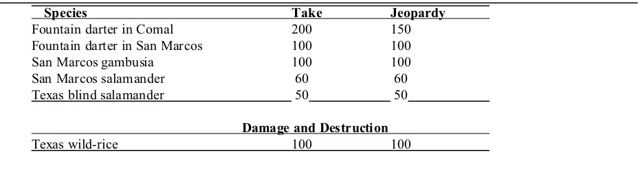
Regional actions center upon maintenance of sufficient spring flows and maintenance of water quality so that the integrity of the ecosystems and survival and recovery of the species are not compromised. The determination of sufficient spring flows was made by the FWS as shown in Table 2.
These spring flows were based on available information and the best professional judgment of FWS personnel. Actual data on impacts of spring flows on individual species are not available. The values reflect the assumptions that there are no effective mechanisms in place to manage either groundwater withdrawals or nonnative species that damage habitat. The FWS leaves open the possibility that the values of these flows may be revised downward, either temporarily or permanently, should control of groundwater withdrawals be implemented and/or effective control
Table 2. U.S. Fish and Wildlife Service determination of minimum springflows needed to prevent take, jeopardy, or adverse modification of critical habitat. All flow rates are given in cubic feet per second (cfs). U.S. Fish and Wildlife Service, 1996.
Species Take Jeopardy
Fountain darter in Comal 200 150
Fountain darter in San Marcos 100 100
San Marcos gambusia 100 100
San Marcos salamander 60 60
Texas blind salamander 50 50
Damage and Destruction
Texas wild-rice 100 100
of nonnative species be found. Of particular interest is the nonnative Giant Ramshorn Snail which feeds on vegetation that provides both cover and sites for egg deposition by the Fountain Darter. As shown in Figure 2, maintenance of minimum spring flows of 200 cfs at Comal Springs requires that water level elevations in the San Antonio index well, J-17, do not fall below 650 msl.
In the event that all actions fail to prevent declines in spring flow below jeopardy levels, the Recovery Plan also contains strategies to prevent extinction of listed species through use of external refugia and captive propagation/cultivation programs. The contingency plan identifies responsible parties, establishes flow-based triggers for removing organisms, defines conditions and location of refugia and specific conditions for reintroduction. Using the Fountain Darter as an example, the contingency plan establishes a trigger point for Comal Springs of less than 50 cfs for four consecutive days, specifies collection of standing stocks of 100 pairs from three locations within the ecosystem and additional collections at the trigger point, presents a detailed propagation plan and provides for collection of salvage stocks when a large die-off in the wild is likely.
THE EDWARDS AQUIFER AUTHORITY
The Edwards Aquifer Authority (EAA) was created by the state legislature in 1993 in an effort to prevent implementation of an emergency withdrawal reduction plan developed by the Court Monitor in connection with the Sierra Club lawsuit involving the ESA. Subsequent litigation prevented EAA from operating until the Texas Supreme Court upheld the validity of the EAA and its enabling legislation as amended in 1995. The EAA officially began operations on June 28, 1996, assuming all existing assets, staff, obligations and programs of the Edwards Underground Water District (EUWD) which it replaced.
The EAA was empowered with broad authority to plan and manage groundwater withdrawals, but the legislature stopped short of modifying the existing rule of capture for groundwater. EAA must, however, install meters on all wells (small wells excluded) and establish limits based on claims of historical pumpage. It must also implement a critical period management plan.
When the EAA Board began to function with an initial complement of appointed Directors, it was immediately faced with a crisis caused by an extended drought. On August 1, 1996, water elevations in J-17 were 632.7 msl and flows at Comal Springs had fallen to 95 cfs, well below the jeopardy level. The appointed Board, lacking an approved management plan, failed to declare an emergency in order to reduce pumpage. Activities under the FWS Recovery Plan were implemented, and members of endangered and threatened species were collected and removed to refugia. Flows at Comal Springs continued to drop below 90 cfs before they began to increase with the end of the irrigation and major outdoor water use season.
In the fall of 1996, newly elected directors of the EAA took their positions. Legislation changed the mechanism for funding from that of taxes utilized by the EUWD, which the EAA replaced, to a dependence on pumpage fees obtained following a permitting process for wells in the region. The EUWD Board, before it was abolished, spent much of the reserves of the EUWD. When the EAA directors took over the former operation of the EUWD they were left with a situation of having to operate on existing funds until the new fees could be collected. They are just now getting the well permitting system in place, and they have been unable to collect fees to support the operation of the EAA. It is expected that when efforts are made to enforce the provisions of the EAA Act, further litigation will occur, placing an additional financial burden on the EAA. It is anticipated that some type of assistance for initial funding will be requested from the current 75th Legislature.
SUMMARY
REFERENCES
Brune, Gunnar. 1981. Springs of Texas Vol. I. Branch-Smith Inc., Fort Worth, Texas. 566 p.
EUWD, 1994. Edwards Aquifer hydrogeologic report for 1993. Rpt. 94-04. Edwards Underground Water District. San Antonio, Texas. 1994. 62 p. + appendices
EUWD, 1995. Edwards Aquifer hydrogeologic report for 1994. Rpt. 95-07. Edwards Underground Water District. San Antonio, Texas. 1995. 60 p. + appendices
GBRA, 1996. Guadalupe-Blanco River Authority Annual report. Guadalupe-Blanco River Authority, Sequin, Texas. 37 p.
Grubb, Herbert W. 1997. The Edwards Aquifer: Conflicts surrounding use of a regional water resource. Water Resources Update 106, 39 p.
Harden, R. 1992. Prepared testimony for Texas Water Commission Hearing in San Antonio on June 30, 1992. 6 p. + 7 Figures
Langecker, T. G. and G. Longley. 1993. Morphological adaptations of the Texas blind catfishes Trogloglanis pattersoni and Satan eurystomus (Siluriformes: Ictaluridae) to their underground environment. Copeia. 93(4): 976-986.
Longley, G. 1978. Status of Typhlomolge (=Eurycea) rathbuni, the Texas Blind Salamander. Endangered Species Report No. 2, Special Publication, U.S. Fish and Wildlife Service, Albuquerque, New Mexico. 45 pp.
Longley, G. 1981. The Edwards Aquifer: Earth's most diverse groundwater ecosystem? International Journal Speleology 11(1-2):123-128.
Longley, G. 1995. The relationship between long term climate change and Edwards Aquifer levels, with an emphasis on droughts and spring flows. Proc. of the 24th Water for Texas Conf.: Research Leads the Way. TWDB, TWRI, TWCA. Austin, Tx. pp. 109-119.
Longley, G. 1992. The subterranean aquatic ecosystem of the Balcones Fault Zone Edwards Aquifer in Texas - Threats from over pumping. Proceedings of the First International Conference on Ground Water Ecology. April, Tampa, Fla. Amer. Water Resources Association pp. 291-300.
Moore, J. and T. Votteler. 1995. Draft Habitat Conservation Plan for the Edwards Aquifer (Balcones Fault Zone - San Antonio Region). Prepared for the United States District Court - Western District of Texas. Lucius D. Bunton, Senior Judge. 314 p.
SAWS, 1997. Information obtained from the San Antonio Water System WWW site Feb. 3, 1997.
Schenkkan, Pete. 1997. Legal impediments to integrated water resource management. Water Resources Update 106, 46 p.
Smith, Rodney T. and Roger Vaughn (eds.). 1996. Litigation Update.Groundwater Regulation, Texas v. Medina County. Water Strategist 10(2): 10 and 20.
U.S. Fish and Wildlife Service. 1996. San Marcos/Comal (Revised) Recovery Plan. Albuquerque, New Mexico. pp. x + 93 with 28 pages of appendices.
Wanakule, N. 1990. Stochastic drought analysis of the Edwards Aquifer. No. R1-90. Edwards Aquifer Research and Data Center, Southwest Texas State University. San Marcos, Texas. 32 pp.
Wanakule, N. 1988. Regression analysis of the San Marcos spring flows and water levels of the Index well in San Antonio. No. R1-88. Edwards Aquifer Research and Data Center, Southwest Texas State University, San Marcos, Texas. 33 p. + appendices
Wanakule, N. 1995. A lumped parameter model for the Edwards Aquifer. Proc. of the 24th Water for Texas Conf.: Research Leads the Way. TWDB, TWRI, TWCA. Austin, Tx. pp. 89-98.
Glenn Longley is a Professor of Biology and Director of the Edwards Aquifer Research and Data Center located on the campus of Southwest Texas State University in San Marcos. His research involves both vertebrate and
invertebrate species within the Edwards Aquifer ecosystem and the impacts proposed management schemes may have on biological, chemical and physical components of that ecosystem.