Available Online at www.ijpret.com 418
INTERNATIONAL JOURNAL OF PURE AND
APPLIED RESEARCH IN ENGINEERING AND
TECHNOLOGY
A PATH FOR HORIZING YOUR INNOVATIVE WORK
WEB BASED SPATIAL DATA INFRASTRUCTURE TO FACILITATE E-SERVICES
IN RURAL INDIA
PANKAJ KUMAR DALELA, NIRAJ KANT KUSHWAHA, ANURAG YADAV, PRASHANT BANSAL,ARUN YADAV, VIPIN TYAGI
Centre for Development of Telematics, Mehrauli, New Delhi, India
Accepted Date: 15/03/2016; Published Date: 01/05/2016
\
Abstract: India has versatile geography and a large number of human resources live here. In urban India the services like
health, education are available but in rural India there is still crunch of these services. About 70 percent of population of
India resides in rural areas; they require access to these services. In order to provide these services we should be able to
manage centrally but deliver remotely. To manage these services we require records in topographic representation so that
decisions can be taken based on terrain, weather conditions, demography of rural India. In this paper we have proposed a
solution to remotely collect, manage and correlate GIS information clubbed with Census of India data, so that services can
be configured and delivered. In present study, National Optical Fiber Network (NOFN) project of government of India is
taken and we have created Geo-Database for Optical Fiber. NOFN project has a target to connect village unit named Gram
Panchayat (GP) with optical fiber to provide broadband connectivity in GP so that rural people of India can access
E-Services like e-health, e-education etc. This study is extremely fruitful due to following a) Centralized Geographical
Information System (GIS) database of resource (optical fiber) b) Administrative ease for monitoring c) GIS data created is in
use for other project of NOFN and d) possibility of data creation for other E-Services of Government of India.
Keywords—GIS, NOFN, E-services in rural India, Geo Database
Corresponding Author: MR. PANKAJ KUMAR DALELA Access Online On:
www.ijpret.com
How to Cite This Article:
Available Online at www.ijpret.com 419 INTRODUCTION
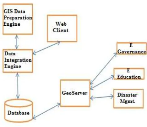
In this paper we are presenting a solution for providing e-services in rural India using Geo Database. Geo Database consist vector and raster Geographical Information System (GIS) data. This data is organized in a way that it can be accessed and utilized for different usage. Here in this paper we have taken case where this data is used for planning of Gigabit Passive Optical Network (GPON) in National Optical Fiber Network (NOFN) project of Govt. Of India. Under NOFN project Govt. Of India will connect 2.50,000 village units named Gram Panchayat (GP) with optical fiber using GPON technology to provide broadband connectivity. Through this broadband connectivity even remote villages of India, where even road connectivity is not proper, will be able to use and benefited by services like e-heath, e-medicine, and e-education.
Providing services in rural India is a big challenge due to diverse and vast geographic conditions. Road Connectivity is poor in villages of India especially in rainy season some villages are disconnected by rest of India. In India there are places where temperature could rise up to 50 degree Celsius and go down up to -22 degree Celsius. So in this kind of adverse climate, any kind of sophisticated system may fail. As mentioned in [1], rural India is so vast and diversified that any commonly known approaches that work well in other countries may not work well in rural India. Seeing these we have developed a centralized approach that can be used to access from remote locations. Following figure shows our approach towards the solution
Available Online at www.ijpret.com 420 remote users. Section IV describes about Web Based Secured mechanism and section V discuss about how using Open Source Database and GIS Mapping Server we have cleaned, correlated and optimized data in an automatic manner.
II. RURAL INDIA SCENERIO
A. Challenges
India has an area of approximately 32 Lakhs square kilometer. From north to south length is approximately 3000 kilometer and from east to west it is around 3200 kilometer. India has rain forest, hill terrain, coastal areas and deserts. Road network to these diverse areas are not proper, some places are not even connected. Since GPON services run over optical fiber and optical fiber is laid mainly under the roads, so GIS road information is very important. In NOFN existing fiber is used for planning of new network. We need to have existing fiber information, but that is not completely available. Apart from roads and fiber, GPON planning for e-services also requires GIS information of exchanges, GPs, and other important point like Fiber Point (from where new fiber can be connected), these information integrated with Census Of India information needs to be available for effective GPON planning. In short we can say due to geography and lack of proper GIS data (road, fiber, exchange, fiber point, splitters) it is very difficult to realize the dream of providing services to the people of rural India. Among these e-services health service is the most important service. For health e-services our approach is inspired by approach mentioned in [2]. Following figure best depicts challenges faced in implementing services in rural India.
Available Online at www.ijpret.com 421 based Client-Server System. The system is used to create GIS road data, GIS fiber data, Gram Panchayat point data, fiber point data, hospitals etc. Since going to villages and collecting information is not feasible solution hence we created a centralized system which will act as server to various clients connected to central GIS data repository.
Fig. 3. Approach of Proposed Solution
Following are the benefits of this approach
• Data repository at central place
• Web based access to remote areas
• GIS data created can be verified using central server
• GIS data processing is done at central places reducing time and increasing accuracy.
III. CENTRALISED APPROACH SOLUTIONS
A. GIS Repository
Available Online at www.ijpret.com 422 Database due to its capability of handling GIS data. GIS repository created for rural India has following advantages.
• Keeping data at central location gives enormous exposure to use data for different services like same data can be used for e-health, e-education and other e-services planned and executed by Govt. for rural India.
• After creating GIS repository, it can be updated, modified and enriched remotely.
B. Remote Accesibility
E-services for rural India should be accessible from remote areas. These services will be accessed from remote villages where maintenance of any system is difficult. Here in our approach we have used Web based centralized system using Open source GIS database in Centralized System. Since these services are provided over GIS, our solution for e-services in rural India uses Open Source MapServer (GeoServer) for visualization over GIS. This remote accessibility is provided over mobile phone also. Mathematically this could be understood in the following way
Point Asset: Gram Panchayat, Splitter, Connector, Landmark
Line Asset: Fiber, Roads, Power Grid Cables, Railway Track
P: {set of point asset}
L: {set of line asset}
method createPoint (id b, point p)
{
get source from p
if p ∈ P then
do nothing
else
for point Layer id b do
Available Online at www.ijpret.com 423 End for
End if
}
method createLine (base polygon id, multipoint [c1, c2, . . ])
{
∀ [c1, c2...] multipoint ∉ L
Set base temp
for all temp
compute DataProcessing*
end for
}
* Algorithm mentioned in data processing section
IV. WEB BASED SECURE MECHANISM
Our Solution to e-services is intended to be delivered at remote areas of rural India. Availability of resources like data storage capacity (cooling of data center and storage) in rural India are negligible hence we have designed a web based system that needs only browser at client side. Following are the features of this web based approach
• GIS Data collection required for e-services can be done remotely using our approach and application. Using the solution user can create, modify GIS data used in e-services. Our approach here is motivated by online data collection methods suggested in [3].
• Login based secured access system for security and tracking purpose.
• Administrator and other users can easily access our system and hence can contribute (GIS data create, update)
Available Online at www.ijpret.com 424 Huge GIS data is required for creating infrastructure for providing e-services. Being an approach for rural India and seeing the cost and effectiveness of clean and correct GIS data, we decided to use Open Source software as a platform to build our solution. We required big database, for that we have used open source spatial database PostGIS. PostGIS has a capability to store, retrieve and operate on GIS data. In [4] also the capability of spatial database has been shown. As already mentioned in the previous section for mapping services we used open source Map Server named GeoServer. This server can overlay layers with their attributes. Satellite images are an important part of data creation and processing, images provided by ISRO’s BHUWAN has been used. Since satellite images consume much of the big data services, following mathematical and algorithmic approach resolves the need to keep all data at one place. Mathematically it is shown that from remote machine we can access big data without effecting time complexity of the algorithm.
MaxFolder : {Set folders of images}
MaxZoom :{ maximum zoom of images}
method getTile (lat, lon, zoom)
{
Latitude tile
Longitude tile - Math.log (Math.tan (Math.toRadians(lat)) + 1 / Math.cos(Math.toRadians(lat))) / Math.PI) / 2 * (1 << zoom))
return ((MaxZoom - zoom) + "/" + lattile / MaxFolder + "/" + longtile % MaxFolder + "/" + longtile / MaxFolder + "/" + longtile % MaxFolder);
}
VI. DATA PROCESSING
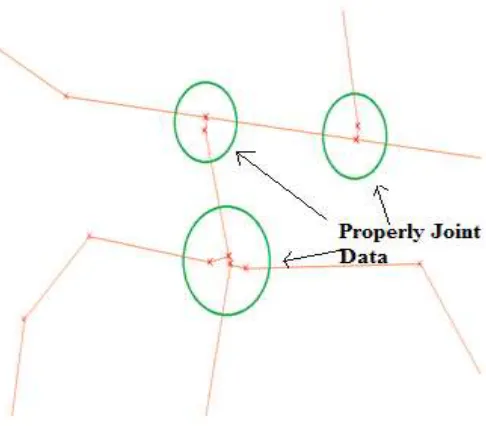
Data created by users is generally not usable for e-services. It has to be cleaned and make usable for running routing algorithms. Data has following problem
• Not aligned to satellite images.
• Disjoint data, unconnected geometries in GIS network.
Available Online at www.ijpret.com 425 • Redundant information
Data cleaning, road breaks join, adding attributes to data are the objectives of data processing. Data processing on GIS digital data focuses on cleaning of data including data redundancy check, splitting line sections, correcting disjoint sections, adding attribute to data thus making data usable for other purposes also
Fig.4 shows a glimpse of raw, unprocessed data, here in this image we can see that geometries (polylines) are disjoint. The geometry depicts roads and if roads are disjoint then running services over this data may lead to inappropriate service configuration that may result in bad e-services. For example for providing broadband connectivity if this data is used then it will lead to wrong path for laying fiber. Laying fiber on wrong path may incur huge financial loss.
Raw data is processed through multiple road cleaning algorithms developed by us which are inspired by famous Dijkstra’s algorithm. Data cleaning process can best understood mathematically
L: {set of fiber segment}
G: {set of Gram Panchayat and OLT}
B (Li): {set of fiber break lying on fiber segment Li}
L sp: {set of suspended fiber segment}
Available Online at www.ijpret.com 426 For each i < n (G) // up to Gram Panchayat Number
If ((B (L j) != G i))
For each (B (L j) // every break should be part of two fibers
Then if B (L j ) ∉ L j
Add fiber segment to L sp
Now since we have found out what are the segment that are open ended (other than Gram Panchayat), now we need to process those open ended fiber as shown below mathematically
For each i B (Li) // for each fiber break point
For each j of L sp j
Initialize shortest vertex distance to infinite
dist (L sp j) ∞
If (dist [B (Li)), L sp j )] < dist (L sp j) )
Then dist (L sp j) dist [B (Li)), L sp j )]
Create list of Vertex, Edges
List (v,e) add B (Li)), L sp j
Now join vertex to edge
For each List (v,e)
Join v,e
Available Online at www.ijpret.com 427 Fig. 5. GIS Data after Cleaning & Processing
VII. USE CASE
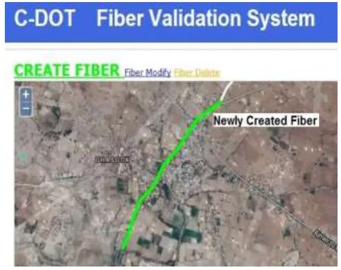
Using our centralized solution of GIS data creation for Nation Optical Fiber Network (NOFN) project of Govt. of India , we have created massive GIS data for three pilot sites of NOFN project naming Panisagar block in North Tripura district of Tripura, Parvada block of Vishakhapatnam district of Andhra Pradesh, Arain block of Ajmer district of Rajasthan. This data creation solution is based on Open Geo Consortium (OGC) compliant web services as mentioned and described and used in [5].
Fig. 6 shows process of data creation in Arain block of Ajmer district. Here in this district we created fiber to the remote areas. These fibers were not present in database but in actual they were laid. So we opened our application to the officers of Bharat Sanchar Nigam Limited (BSNL) with whom we were working. Being local to those areas they created fiber on our application. This fiber, when updated went through automatic data processing algorithms.
Available Online at www.ijpret.com 428
USE CASE
Using our centralized solution of GIS data creation for Nation Optical Fiber Network (NOFN) project of Govt. of India , we have created massive GIS data for three pilot sites of NOFN project naming Panisagar block in North Tripura district of Tripura, Parvada block of Vishakhapatnam district of Andhra Pradesh, Arain block of Ajmer district of Rajasthan. This data creation solution is based on Open Geo Consortium (OGC) compliant web services as mentioned and described and used in [5].
Fig. 6 shows process of data creation in Arain block of Ajmer district. Here in this district we created fiber to the remote areas. These fibers were not present in database but in actual they were laid. So we opened our application to the officers of Bharat Sanchar Nigam Limited (BSNL) with whom we were working. Being local to those areas they created fiber on our application. This fiber, when updated went through automatic data processing algorithms.
After data processing it is useful for further processing to be done by NOFN project.
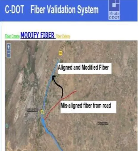
Available Online at www.ijpret.com 429 Figure below shows how in this block fiber data was not aligned to satellite road due to which planning for laying new network and monitoring of network will not be possible.
Available Online at www.ijpret.com 430 Similarly the data creation through our solution has been done for Panisagar block of North Tripura district and Parvada block of Vishakhapatnam district.
CONCLUSION
The solution has already been used in massive GIS data creation and processing. The data created by this solution is being used for NOFN project of Govt. of India for connecting 2, 50,000 Gram Panchayat (GP) of rural India. Many e-services will be configured and used over the broadband network laid using the data created by our solution. Being a centralized approach based on our customized algorithms inspired by algorithms mentioned in [6], this solution is not only saving time but accuracy also has been increased to many fold. Since GIS is immerging field in India, many challenges with respect to accuracy of data are being faced by us, using this approach and solution minimizes rework. It is a “create once used many times” approach that is saving a lot of time and resources.
ACKNOWLEDGMENT
We have used data creation approach and solution for NOFN project of Govt. of India. We are really thankful for support and guidance received from executing agency Bharat Broadband Network Limited (BBNL) whose NOFN is the prime responsibility.
REFERENCES
1. L.R. Yadav, N. Kapoor, R.S. Singh, “Strengthening government decision making process through integrated SPIDER & e-MANCHITRA Online Portals”Emerging Applications of Information Technology (EAIT), 2012 Third International Conference, pp. 223-226, 2012.
2. A. Dasgupta, R. Kamble, S.K. Ghosh, Acharya, P.S. “GeoSMS framework for information acquisition in rural public health management system”, India Conference (INDICON), 2013 Annual IEEE, pp. 1-4, 2013.
3. K. Shirima, O. Mukasa, J. Schellenberg, F. Manzi, D. John, A. Mushi, M. Mrisho, M. Tanner, H. Mshinda, and D. Schellenberg, "The use of personal digital assistants for data entry at the point of collection in a large household survey in southern tanzania," Emerging Themes in Epidemiology, vol. 4, pp. 4-5, 2007.
Available Online at www.ijpret.com 431 5. Guangshi Li, “Research on building the information sharing platform based on the OGC web services”, Information Management, Innovation Management and Industrial Engineering (ICIII), 2013 6th International Conference, vol. 2, pp. 200-203, 2013.