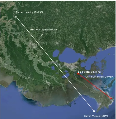
One-Dimensional Dynamic Modeling of the Lower Mississippi River
Full text
Figure


Related documents
This article provides information about organic food market structure and price premiums at the mass-market retail level by analyzing product and price data collected on a single
Results : Significant increase in urea, creatinine and aspartate aminotransferase were observed in 7 days administration in both autoinjector and manual injection
To the extent of his interest therein at the time of his death, the gross estate of a cash basis landlord should include such items as crop shares or livestock
Work with the business users to identify the critical business transactions and come up with performance objectives for each.. These performance objectives can then be extended
given that the patient does not have the disease or Pr(T+ | D+)/Pr(T+ | D–); the negative likelihood ratio is the conditional probability of a negative test result given that
Also in attendance were Bob Tucker of the Kodiak Island Borough, Ex-Officio member Robert Gray of USCG, Lee Hickle of Alaska Waste, Stephanie Mason of Threshold and Matt Van Daele
"I am going to address the 4 cloacal reflexes, and you (the client) will address all of the reflexes on your head, shoulders, and neck; with the breath; eyes open and closed."
Trimble ® ’s TerraSync ™ Professional is a full-featured yet flexible data collection and data maintenance software package designed to work seamlessly with
