191
Efficient methodology for object based image analysis
Miss. K. G. Lakade
Dr. R. D.Raut
Dr. V. M. Thakare
SGBAU, Amravati SGBAU , Amravati SGBAU , Amravati
India India India
[email protected] [email protected] [email protected]
Abstract—Object based image analysis (OBIA) has been, and
still is , a relevant research area in computer vision and many more techniques. This method focused on different object based image analysis techniques such as Geographic Object-Based Mosaicing, Range Image Registration Algorithm, Digital Terrain Analysis, Context Aware Decision-Level Fusion in Multiviews Imagery, Object-Based Unsupervised Classification.Object based image analysis methodology uses similar patterns that exist in many real-world images. By interactively detecting similar objects in an image, the image content can be summarized rather than simply distorted or cropped. OBIA method enables the manipulation of image pixels or patches as well as semantic objects in the scene during image analyzing process. Proposed method can use similar objects detection even when they are of various colors, transformed in terms of perspective, or partially occluded.Proposed method can achieve satisfactory results.
Keywords—Object based image analysis; Geographic Object-Based Mosaicin; Range Image Registration Algorithm; Digital Terrain Analysis; Context Aware Decision-Level Fusion in Multiviews Imagery; Object-Based Unsupervised Classification.
I.
INTRODUCTIONTo achieve object analysis applications for general images, proposed method is developedi.e.object matching-based method. This method can detect similar objects even when they are of various colors. In addition to symmetric structures, comparable object level similarities exist in many images. Similar objects may scatter in an image stochastically without an evident pattern. Detecting generic object categories in images and videos are a fundamental issue in computer vision. However, it faces the challenges from inter and intraclass diversity, as well as distortions caused by viewpoints, poses, deformations, and so on.
To solve object variations, this method combine a Geographic Object-Based Mosaicing, Range Image Registration Algorithm, Digital Terrain Analysis, Context Aware Decision-Level Fusion in Multiviews Imagery, Object-Based Unsupervised Classification. Which produce accurate and efficient result. In future, object based image analysis has been accepted as an effective method for processing high spatial resolution multiband image.
II. BACKGROUND
Object-basedmosaicing method prevents individual roof objects from being bisected during the mosaicing process. By testing this method against traditional mosaic products method show that OBM visibly and statistically improves roof structures within the entire scene by better preserving individual roof-object geometry and radiometric
characteristics[1]. Range Image Registration Algorithm is shape growing based algorithm for multi-view range image registration. Experimental results show that the proposed algorithm is very accurate. It can simultaneously perform multi-view registration on a set of mixed range images which correspond to several different objects[2].Digital terrain analysis method implement using Image Segmentation and the OBIA Approach, Identifying Potential Landslide-Affected Areas and Rule-Based Classification of Satellite Imagery Segmentation is an important stage in OBIA. It can be defined as a partitioning process of an image into homogeneous and nonoverlapping regions that are later identified as objects. Various optimization steps, that resulting image segments were analyzed with respect to their spatial, spectral, and textural parameters.The brightness parameter can therefore be used to detect landslides on the basis of characteristics[3]. Context aware object recognition strategy composed of multiple steps is proposed for solving object recognition difficulties in complex urban areas, based on multiviews VHR remotely sensed imagery and digital surface model. The object recognition method is composed of two main stages: single view process and multiviews process. In the first stage, the properties of each segmented region are utilized for object classification on the individual images. Per segment spectral and textural characteristics together with the structural features based on the size, shape, and height of a segmented region generate region’s properties. The second stage of the proposed methodology performs decision-level fusion on the multiviews classified regions based on the scene context in order to reduce the ambiguities and uncertainties in the generated classification map[4]. Object-Based Unsupervised Classification method proposed by combining Hierarchical Dirichlet Process (HDP) and Indian Buffet Process (IBP) model to address the problems of unsupervised classification in very high resolution (VHR) panchromatic satellite images [5].
This paper introduced efficient methods for object based image analysis i.e.section I Introduction. Section II discuss Background. Section III discuss Previous work done. Section IV. discuss Existing methodology. Section V Analysis And Discussion. section VI Proposed methodology, outcomes and possible result finally section VII Conclusion of the paper.
III. PREVIOUS WORK DONE
Volume 3, Special Issue 1, ICSTSD 2016
192 geometric and radiometric variations during different acquisition times, the same objects tend to have different spectral characteristics betweenflight lines, resulting in reduced classification accuracies. YulanGuo,et al.[2] has worked on an accurate and robust range image registration algorithm for 3D object modeling.This method based on pairwise course registration algorithms and multi view registration algorithmsPairwise coarse registration is usually accomplished by finding point correspondences through the matching of local features. Pairwise registration algorithm is performed to produce a more accurate solution.A multi-view coarse registration algorithm involves two tasks. The first task is to recover the overlap information between the input range images, and the second task is to calculate the rigid transformations between any two overlapping range images. Multi-view registration algorithms aim to minimize the registration error of all overlapping range images.Thomas Blaschke,et al.[3] has worked on object based image analysis and digital terrain analysis for locating landslides. To establish a semiautomated object-based image analysis (OBIA) methodology for locating landslides.Landslide detection and delineation through earth observation data are considered to be a promising application domain.FatemehTabibMahmoudi,et al.[4] has worked on object recognition based on the context aware decision level fusion in multiviews imagery. This method based on spectral similarities and spatial adjacencies between various kinds of objects, shadow, and occluded areas behind high-rise objects as well as the complex relationships between various object types. This method reduce difficulties and ambiguities in object recognition in urban areas. Using a knowledge base containing the contextual information together with the multiviews imagery may improve the object recognition results. Yang Shu , et al.[5] has worked on object based unsupervised classification of very high resolution panchromatic satellite images by combining the HDP and IBPon Multiple Scenes. This method perform the classification by capturing the classes from the data without requiring training data. Thus, the unsupervised classification methods are widely used to extract geographic thematic information from remote sensing images when a training sample is not available.
This method focused, on object feature extraction,a novel and robust method to mitigate problem. This interactive methodology can detect similar objects and compute for their semantic information. Subsequently, it used Geographic Object-Based Mosaicing, Image Registration Algorithm, Digital Terrain Analysis, Context Aware Decision-Level Fusion in Multiviews Imagery, Object-Based Unsupervised Classification. Future work will aim to implement the proposed algorithms in a Graphics Processing Unit with parallel computing techniques to achieve a faster performance.
IV. EXISTING METHODOLOGY
Geographic object based mosaicing is defined as joining together of two or more image scenes into a larger composition which represents a portion of the Earth.This method visuallyimproved roof shapes within the scene, reduced processingtime , more accurate hot-spot detection and abetter data set for more accurate home energy modelsas thethermal
imagery for each roof are from a single acquisition time[1].Range image registration is a fundamental researchtopic for 3D object modeling and recognition.This algorithm is accurate and robust algorithm for pairwise andmulti-view range image registration. First extract a set ofRotational Projection Statistics features from a pair ofrange images, and perform feature matching between them[2]. Object based image analysis and digital terrain analysis has worked on landslides complex natural phenomena. A rangeof parameters needs to be considered for their semi automateddetection. They represent complex geomorphologic processes,spectral characteristics from satellite images alone may not besufficient for accurate identification of landslide locations.Semiautomated object-based classification appears to be verysuitable for this task. In order to maintain the transferability ofthis approach , method used as few spectral parameters aspossible like brightness, complemented by spatial,morphometric, and textural parameters[3]. Object recognition strategy on context aware decision level fusion has two main stages single view and multiviews processes. In the single view process, defining region’s properties for each of the segmented regions, the object-based image analysis (OBIA) is performed independently on the individual views. In the second stage, the classified objects of all views are fused together through a decision-level fusion based on the scene contextual information in order to refine the classification results. Sensory information, analyzing visibility maps, height, and the structural characteristics of the multiviews classified objects define the scene contextual information[4] The main contribution of Object-Based Unsupervised Classification method is a novel application framework to solve the problems of traditional probabilistic topic models and achieve the effective unsupervised classification of very high resolution (VHR) panchromatic satellite images. In this framework, a VHR satellite image is first oversegmented into basic processing units and divided into a set ofSub images.The hierarchical structure of our model transmits the spatial information from the original image to the scene layer implicitly and provides useful cues of classification[5]. DATASET:
Context aware object recognition methodology based on three benchmark datasets:
1) multiangular Worldview-2 satellite images over Rio de Janeiro in Brazil and
2) multiviews digital modular camera (DMC) aerial images over a complex urban area.
The Context aware object recognition method results represent that using the contextual information together with a decision-level fusion of multiviews, the object recognition difficulties and ambiguities are decreased and the overall accuracy and the kappa are gradually improved for both of theWorldView-2 and the DMC datasets.
V. ANALYSIS AND DISCUSSION
193 to describe shapes of objects.This has numerous application areas including education, entertainment,cultural heritage , medical industry , manufacturing and robotics A model can be built using either Computer Aided Design (CAD) tools or 3D scanning equipments. 3D scanning techniques are the best choice when dealing with free-form objects. However, the range image acquired from a single viewpoint cannot represent the complete shape of an object. Therefore, a 3D object modeling technique is required to register and integrate the set of range images that are acquired from the different viewpoints[2]. Object based image analysis and digital terrain analysis method implemented using Image Segmentation and the OBIA Approach, identifying potential landslide affected areas and rule based classification of satellite imagery and by incorporating spectral information and spatial characteristics,together with textural data and contextual information, OBIA approaches the way that humans visually interpret the information on aerial photos and satellite image [3]. Context aware decision level fusion method proposed spectral similarities and spatial adjacencies between various kinds of objects, shadow, and occluded areas behind high rise objects as well as the complex relationships between various object types lead to the difficulties and ambiguities in object recognition in urban areas. Using a knowledge base containing the contextual information together with the multiviews imagery may improve the object recognition results [4].Object based unsupervised classification method implemented by classification process it viewed as associating every pixel of a remote sensing image to a class label chosen from a predefined set of class labels in a supervised way or an aggregated class in an unsupervised way. Two main approaches are successfully used in the classification of images are
the supervised methods and the unsupervised methods. The unsupervised methods, known as clustering methods, perform the classification by capturing the classes from the data without requiring training data. Thus, the unsupervised classification methods are widely used to extract geographic thematic information from remote sensing images when a training sample is not available [5].
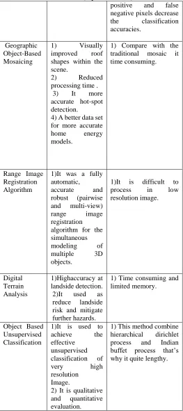
Object based image analysis techniques
Advantages Disadvantages
Context Aware Decision-Level Fusion in Multiviews Imagery
1)This method has novel and robust method to mitigate the problem and can detect similar
object and
compute for their semantics
information.
1) This method depends on classification accuracy of each individual image. objects such as buildings may cause occlusion and shadow areas in the remotely sensed imagery. In such a situation, true class labels of some parts of the object regions cannot be detected. Therefore, large numbers of false
positive and false negative pixels decrease the classification accuracies.
Geographic Object-Based Mosaicing
1) Visually improved roof shapes within the scene.
2) Reduced
processing time . 3) It more accurate hot-spot detection.
4) A better data set for more accurate home energy models.
1) Compare with the traditional mosaic it time consuming.
Range Image Registration Algorithm
1)It was a fully automatic, accurate and robust (pairwise and multi-view) range image registration algorithm for the simultaneous modeling of multiple 3D objects.
1)It is difficult to process in low resolution image.
Digital Terrain Analysis
1)Highaccuracy at landside detection. 2)It used as reduce landside risk and mitigate further hazards.
1) Time consuming and limited memory.
Object Based Unsupervised Classification
1)It is used to achieve the effective
unsupervised classification of
very high
resolution Image.
2) It is qualitative and quantitative evaluation.
1) This method combine hierarchical dirichlet process and Indian buffet process that’s why it quite lengthy.
Table 1: Comparison between different object based image analysis techniques
.
Volume 3, Special Issue 1, ICSTSD 2016
194 Proposed method focused on different object based image analysis techniques such as Geographic Object-Based Mosaicing, Range Image Registration Algorithm, Digital Terrain Analysis, Context Aware Decision-Level Fusion in Multiviews Imagery, Object-Based Unsupervised Classification.
Proposed method implemented by two processesSingle view process and Multi view process.
\
Single view process
Multi view process
Fig1. General structure for object recognition strategy.
1)Single view process:This process focused on Spectral features , Textural features and Structural features.
A. Spectral features :
The ratios between the reflectance valuesof every possible combination of spectral bands arecalled index ratios,those can be used to establish the spectralcharacteristics of a region
.
B. Textural features:
Textural features can be measured based on the gray value relationships between pixels over the entire pre identified segmented region. Calculating structural features based on the spatial characteristics and heights of segmented regions provide another part of the region’s properties for using in the object classification process.
C. Structural features
:
Calculating structural features based on the spatial characteristics and heights of segmented regions provide another part of the region’s properties for using in the object classification process.
2) Multi view process:
This process includePreanalysis on classified regions and Decision level fusion.
A. Preanalysis on classified regions:
The preanalysis is based on generating total visibility map from the summation of all of the individual visibility maps.
B. Decision level fusion
For the decision-level fusion of the classified regions in multiviews, results of the visibility analysis are utilized through a higher level context aware strategy. This method has novel and robust method to mitigate the problem and can detect similar objectand compute for their semantics information.
OUTCOME AND POSSIBLE RESULT
The result of this method focused on Geographic Object-Based Mosaicing, Range Image Registration Algorithm, Digital Terrain Analysis, Context Aware Decision-Level Fusion in Multiviews Imagery, Object-Based Unsupervised Classification. The primary objective of system is to identify the location of the objects accurately instead of obtaining a very accurate boundary .A context aware strategy is proposed for decision-level fusion of the object-based image analysis on multiviews very high resolution imagery and digital surface model. These method is the most accurate one.
VII. CONCLUSION
Thus, this method focused on different object based image analysis techniques such Geographic Object Based Mosaicing, Range Image Registration Algorithm, Digital Terrain Analysis, Context Aware Decision-Level Fusion in Multiviews Imagery, Object-Based Unsupervised Classification.The performance of different techniques over the images can be extrapolated to the result obtain real ones. The output of this method can be regressed with more objective variables which provide best results. By combining the above different techniques for object based image analysis we improve the efficiency and computational time.
VIII. FUTURE SCOPE
In future, object based image analysis has been accepted as an effective method for processing high spatial resolution multiband image. In future work will aim to implement the proposed algorithms in a Graphics Processing Unit (GPU) with parallel computing techniques to achieve a faster performance.
References
[1] Mir Mustafizur Rahman and Geoffrey J. Hay, “Geographic Object-Based Mosaicing (OBM) of High-Resolution Thermal Airborne Imagery (TABI-1800) to Improve the Interpretation of Urban Image
Region’s properties
Spectral
features Textural features Structural features
Preanalysis on classified
regions
195
Objects”, IEEE GEOSCIENCE AND REMOTE SENSING LETTERS, VOL. 10, NO. 4, JULY 2013.
[2] YulanGuo and FerdousSohel, “An Accurate and Robust Range Image Registration Algorithm for 3D Object Modeling”, IEEE TRANSACTIONS ON MULTIMEDIA, VOL. 16, NO. 5, AUGUST2014.
[3] ThomasBlaschke and BakhtiarFeizizadeh, “Object-Based Image Analysis and Digital Terrain Analysis for Locating Landslides in the Urmia Lake Basin, Iran”, IEEE JOURNAL OF SELECTED TOPICS IN APPLIED EARTH OBSERVATIONS AND REMOTE SENSING, VOL. 7, NO. 12, DECEMBER 2014.
[4] FatemehTabibMahmoudi and FarhadSamadzadegan, “Object Recognition Based on the Context Aware Decision-Level Fusion in Multiviews Imagery”,IEEE JOURNAL OF SELECTED TOPICS IN APPLIED EARTH OBSERVATIONS AND REMOTE SENSING, VOL. 8, NO. 1, JANUARY 2015.