A b s t r a c t. In the study presented here, the long-term effects of two land uses of forest and tea garden on soil aggregate stability as an indicator of soil quality were investigated at three landscapes in Lahijan, North Iran. In each landscape, soil samples were col-lected from two slope positions and two depths of adjacent forest and tea garden, and were analyzed for their physical and chemical properties including aggregate size distributions by dry and wet sieving. Soil properties and aggregate stability indices were com-pared for the two land uses by the algorithms of nested design. The results showed that organic matter content, hydraulic conductivity, field capacity moisture content, mean weight diameter, and geo-metric mean diameter of the soil aggregates were significantly lower for the tea garden than for the forest, while bulk density and fractal dimension of aggregates were higher. Traffic and cultural operations, combined with increased organic matter decompo-sition in the tea garden, disintegrated the large aggregates into smaller aggregates (0.25-0.5 mm), resulting in a lower proportion of large aggregates in these soils. All measured soil properties were statistically the same for two depths of 0-15 and 15-30 cm, except for organic matter, field capacity and permanent wilting point. There were also no differences between two slope positions re-garding the soil properties.
K e y w o r d s: land use, aggregate stability, soil erosion, slope position, humid climate
INTRODUCTION
Fertile soil and good quality water are vital for human survival and must be used properly and conserved against different types of degradation. Soil degradation is a world problem involving various forms of water and wind erosion, salinization, acidification, water logging, decline in soil fertility, pollution, and compaction. Some of the soil degra-dation forms, like erosion, are irreversible in a short time. Water erosion rate is affected by lithological and soil
proper-ties, climate, topography, and land use (Kirkbyet al., 2000). The importance of land use is greater than that of other factors, because of the direct human involvement.
The area of forests and pastures in Asia decreased by about 313 mln ha during the period from 1970 to 1980, and that was the greatest reduction in the world (Chuluun and Ojima, 2002). In the past (1942), the area of forests in Iran was 19.5 mln ha. Last estimates indicated that the forest area has decreased to 12 mln ha. About 1.9 mln ha of these forests extend throughout the south coast of the Caspian Sea, in the northern part of the country. Some of the main causes of soil erosion and degradation in Iran are overgrazing, land use changes, and land mismanagement.
Soil structure has a key role in the functioning of soil, its capacity to support plant and animal life, water availability, soil erodibility and response of soil to changes in the environ-ment. Soil structure holds a vital, but often neglected role in sustai-nable food production and achievements toward a well deve-loped society. Different management practices can affect the soils aggregate stability as an index of soil structure status and soil quality (Czy¿ and Dexter, 2009; Josaet al., 2010). Differences in soil aggregate stability may largely influence soil susceptibi-lity to degradation (Lipiecet al., 2006, Sheinet al., 2010).
The aim of this study was to assess the long-term effects of land use (forest and tea garden) on some soil properties, includ-ing soil structure and its stability in a humid region of Iran.
MATERIALS AND METHODS
The study area is located to the southeast of the city of Lahijan (37° 09’ to 37° 11’ N, 50° 02’ to 50° 03’ E; 160 m a.s.l.), Guilan province, North Iran. The prevailing climate of the region is humid temperate, with annual precipitation
Long-term effects of land use on soil aggregate stability
S. Abrishamkesh
1, M. Gorji
1, and H. Asadi
2*
1
Department of Soil Science, University of Tehran, Karaj 31587-77871, Iran 2
Department of Soil Science, University of Guilan, Rasht 41635-1314, Iran
Received March 31, 2010; accepted September 22, 2010
© 2011 Institute of Agrophysics, Polish Academy of Sciences *Corresponding author’s e-mail: [email protected]
A A
Agggrrroooppphhyhyysssiiicccsss
of 1 320 mm, mean annual temperature of 16.5°C. Soil moisture and temperature regimes are Udic and Thermic, respectively. Dominant soils in the study area are Typic Hapludalf, Ultic Hapludalf and Typic Udurtent. Dominant vegetation covers in the forest are Alnus subcordata, Parrotia persica,Discopyros lotus,Quercus macranthera, Carpinus, and evergreen plants.
Based on the land use map of the region and field surveying, three landscapes were selected for sampling, in which tea gardens were adjacent to the forest. The land-scapes were the same in slope steepness, shape, and aspect at both land uses. The duration of tea cultivation was between 40 and 50 years. Soil samples (about 4 kg) from depths of 0-15 and 15-30 cm were randomly collected from summit and shoulder positions of each landscape in both land uses. These samples were air dried and divided into two parts. One portion was ground and sieved through a 2 mm screen for physical and chemical analysis. Another portion was sieved through a 9.5 mm sieve for soil aggregates stability test. Core samples of depths 0-5 and 15-20 cm were taken from the same location by a steel core sampler of a 100 cm3 volume (5 cm in diameter and 5 cm in height), with two re-plications, for bulk density and saturated hydraulic conduc-tivity measurements. Soil samples were collected during November of 2007.
Particle size distribution and soil organic carbon were determined by the Bouyoucos hydrometer method (Dane and Topp, 2002) and the modified Walkley-Black wet oxi-dation procedure (Sparks, 1996), respectively. Dry bulk den-sity was determined by the core method, saturated hydraulic conductivity was measured by the falling-head method. The water content of soil samples at field capacity and perma-nent wilting point were determined using the pressure plate apparatus at 0.033 and 1.5 MPa (Dane and Topp, 2002).
Aggregate stability in the layers of 0-15 and 15-30 cm was evaluated by dry and wet sieving method in three replications. In wet sieving, the set of sieves had openings of 4, 2, 1, 0.5, 0.25, 0.1 and 0.05 mm in diameters, and the sie-ving took place in water at 35 oscillations per minute (along 1.3 cm amplitude) for 6 min duration. Weighted percent of water-stable aggregates in different diameter classes and mean weight diameter (MWD), geometric mean diameter (GMD), and fractal dimension of soil aggregates were deter-mined using the wet and dry sieving data.
Fractal geometry is a useful tool in quantifying scale-dependent soil properties such as aggregate mass, particle mass, soil particle surface, surface roughness, hydraulic conductivity,etc. (Salako, 2006). The fractal dimension,D, was calculated as:
N> =x K( )x-D, (1) where: N > x, is the accumulated number of aggregates higher thanx, and K is a constant, relative to the number of fragments in one volume unit. The value ofDis obtained
from the slope of the regression of log N > xvs. log x, assuming that the aggregates have a cubic shape and con-stant density (Perfect and Kay, 1991). The value of D depends on the aggregate fragmentation, therefore, a higher absolute value of D is considered indicative of a higher fragmentation.
The number of aggregates left onith sieve of a nest of sieves can be computed from aggregate mass data as follows (Tyler and Wheatcraft, 1992):
Ni=M x( i) /xi3, (2) where:NiandM(xi) are the number and mass of aggregates left onith sieve of a nest of sieves, respectively,xiis the size of aggregates in mm. Inserting Eq. (2) into Eq. (1) and assuming scale-invariant density and shape of aggregates, the following equation is derived for the estimation of D from mass-size distribution:
[
M x x]
xx x
D ( ) / 3
1 =
-å =K . (3)
Analysis of variance was performed using Statistical Analysis System (SAS Institute, 2001) to determine the significance of land use effect on soil properties based on a nested factorial design. Duncan’s test was used to separate means of measured values. A value ofP< 0.05 was selected to represent statistical significance.
RESULTS AND DISCUSSION
The results (Tables 1 and 2) showed that land use had a significant effect (P<0.05) on soil organic matter, wet mean weight diameter, geometric mean diameter and fractal dimension of aggregates, bulk density, field capacity and weight percent of stable aggregates in the diameter class of 0.25-0.5 mm. Furthermore, land use had a significant effect (P<0.01) on weight percent of stable aggregates in the dia-meter class >4 mm and soil hydraulic conductivity. Among all soil properties only organic matter, field capacity and permanent wilting point were significantly (P<0.05) diffe-rent between the two depths. Bulk density was affected sig-nificantly (P<0.05) by the interaction of land use and depth as well.
Sources of variation df
MWDd MWDw GMDd GMDw D
SOM (g kg-1)
BD (Mg m-3)
Ks (cm h-1)
FC (%)
PWP (%) (mm)
Site 2 2.01** 0.78ns 0.18** 0.04ns 0.007ns 5.93ns 0.01ns 247.9ns 478.6** 145.8ns Land use 1 0.08ns 1.86* 0.00ns 0.12* 0.020* 1236.03* 0.04* 1220.0** 43.0* 10.6ns Slope position 1 0.20ns 0.02ns 0.02ns 0.001ns 0.000ns 197.76ns 0.05ns 0.6ns 3.8ns 6.3ns Depth 1 0.02ns 0.03ns 0.01ns 0.02ns 0.000ns 4748.34* 0.01ns 20.4ns 39.0* 43.1* Site×Slope position 1 0.78* 0.40ns 0.00* 0.04ns 0.002ns 31.64ns 0.04ns 116.0* 15.4ns 15.4ns Land use×Slope position 1 0.37ns 0.04ns 0.06ns 0.04ns 0.000ns 0.00ns 0.00ns 11.9ns 12.6ns 49.5ns Land use×Depth 1 0.01ns 0.05ns 0.00ns 0.000ns 0.000ns 239.30ns 0.04* 16.1ns 6.9ns 12.6ns Error of land use (Site) 2 0.02ns 0.21ns 0.00ns 0.02ns 0.001ns 559.68ns 0.02* 321.2* 139.6* 9.1ns
Total error 12 0.19 0.22 0.01 0.01 0.002 180.62 0.01 55.4 7.2 5.5
*P<0.05, **P<0.01, ns – not significant.
T a b l e 1.Vvariance analysis (mean squares) of dry and wet mean weight diameter (MWDd, MWDw)and dry and wet geometric mean diameter (GMDd, GMDw), fractal dimension of aggregates (D), soil organic matter (SOM), bulk density (BD), soil hydraulic conductivity (Ks), field capacity (FC) and permanent wilting point (PWP)
Sources of variation df
>4 4-2 2-1 1-0.5 0.5-0.25 0.25-0.1 0.1-0.05 <0.05 (mm)
Site 2 279.32ns 54.74ns 36.37ns 3.61ns 1.55ns 7.17ns 0.20ns 9.46ns
Land use 1 584.06** 11.51ns 3.72ns 52.44ns 41.05* 6.52ns 0.07ns 7.60ns
Slope position 1 17.27ns 52.6ns 2.98ns 1.04ns 3.53ns 0.47ns 1.24ns 4.17ns
Depth 1 8.74ns 66.14* 31.05ns 0.01ns 8.52ns 7.72ns 0.87ns 14.73ns
Site×Slope position 1 88.26ns 14.28ns 3.10* 4.59ns 7.88* 6.68ns 1.38ns 9.62ns Land use×Slope position 1 38.11ns 1.15ns 1.41ns 21.38ns 0.01ns 0.56ns 0.01ns 4.74ns Land use×Depth 1 18.70ns 2.71ns 0.10ns 32.74ns 0.23ns 0.00ns 0.01ns 0.49ns Error of land use (Site) 2 66.36ns 15.76ns 2.43ns 0.28ns 22.82ns 17.44* 1.42ns 17.05ns
Total error 12 56.83 12.42 7.00 15.72 7.72 3.03 0.49 5.51
Explanations as in Table 1.
T a b l e 2.Variance analysis (mean squares) of weight percent of stable aggregates in the diameter classes
Land use
SOM MWDd MWDw GMDd GMDw
D
(g kg-1) (mm)
Forest 59.7a 3.5a 3.11a 1.41a 1.26a 3.20b
Tea garden 45.4b 3.4a 2.57b 1.40a 1.12b 3.25a
Means within a column that share the same letters are not significantly different atP< 0.05.
of plant residues returned to the soil. In the forest there is a considerable equilibrium between soil organic matter decomposition and plant residues, but in the tea garden this equilibrium is disturbed by picking off the tea leaves causing a new equilibrium. In addition, excess stems are thrown away while lopping, therefore replacement rate of SOM reduces. Acceleration of soil organic matter oxidation due to microclimate change (higher radiation and evaporation and lower moisture) and agricultural operation in tea garden, which results in degradation of aggregates and more avai-lability of SOM for microorganisms, are other eventual reasons for reduction of SOM.
Dry MWD and GMD of soil aggregates did not differ between the forest and tea garden (Table 3). Soil aggregate stability was high enough in both land uses, which could be affected by the force applied in dry sieving. The wet MWD and GMD of aggregates, however, were significantly greater in the forest soils than in the tea garden soils at 0-30 cm depth.
Fractal dimension of aggregates differed significantly between the forest and tea garden soils in the 0-30 cm horizon (Table 3). According to the fractal fragmentation model, the fractal dimension in soil is expected to be <3, since the inequalityD³3 would require that the probability of grain fragmentation be³1, which is not valid. Perfect and Kay (1991), however, indicated that the value ofD deter-mined from aggregate-size distribution is a measure of soil fragmentation and showed that it can be as high as 3.5.
Lower MWD and GMD and higher fractal dimension of aggregates in the tea garden soil show lower aggregate stability. There is a strong and mutual relationship between soil organic matter and aggregation. Organic matter fortifies aggregation and aggregates protect organic matter from microbial decomposition. Conversion of forest to cultiva-tion caused 61% reduccultiva-tion in MWD for the 0-10 cm layer
and 52% for the 10-20 cm layer (Celik, 2005). Study of land use effects on some structural properties of an Ultisol in south-eastern Nigeria by Igwe (2001) showed that forest land had the highest structural stability, followed by grass-land and oil palm, and arable grass-land had the lowest structural stability. Mbagwu and Piccolo (2004) also reported a re-duction in structural stability of soil aggregates when the forested soils were converted to cultivated soils.
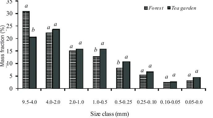
Considering the significance of differences between wet aggregate stability of the forest and tea garden soils, the distribution of the aggregate size classes was analyzed to study aggregate stability among the different size classes (Fig. 1). The tea garden soils had a significantly higher weight percentage of aggregates in the smaller diameter class of 0.5-0.25 mm than the forest soils. In the >4 mm class, however, the forest soils showed greater weight per-centage of aggregates than the tea garden soils. Similar findings were reported by Celik (2005). Small aggregate sizes (<1.2 mm) can be a useful indicator of soil degradation, traffic and cultural operation in tea garden soils having disintegrated the large aggregates into smaller aggregates, resulting in the higher proportion of small aggregates (0.5-0.25 mm) in these soils (Fig. 1). Due to the labile nature of macroaggregate binding agents, the effect of soil manage-ment on macroaggregates and the OM retained within them is greater than that on microaggregates having stable and more humified organic binding agents.
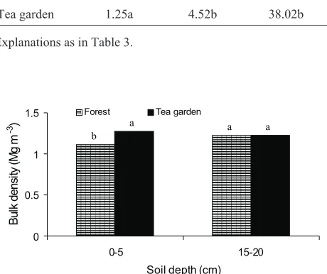
Soils under tea garden had higher bulk density than the soils under forest at the 0-20 cm depth (Table 4). Higher bulk density can be attributed to compaction and degradation of soil structure (Igwe, 2001). Bulk density did not differ bet-ween the forest and tea garden soils at the 15-20 cm depth, but significantly differed in the 0-5 cm soil layer (Fig. 2). This indicates that soil surface is more affected by land use
0 5 10 15 20 25 30 35
9.5-4.0 4.0-2.0 2.0-1.0 1.0-0.5 0.5-0.25 0.25-0.10 0.10-0.05 0.05-0.0
M a ss a c o n %
Size class (mm)
Fo res t Tea ga rden
a
b a a
a a b
a
b a
a a
a a a a
Ma
ss
fra
ct
io
n(%
)
change. Such an increase in bulk density can be due to a re-duction in SOM, more intensive traffic, and/or more impact of rain drops on soil surface in the tea garden than in the forest. Zolfaghari and Hajabbasi (2008) reported that con-version of forest to agricultural land resulted in a significant increase of bulk density from 1.19 to 1.3 Mg cm-3.
Soil hydraulic conductivity was significantly greater in the forest land than in the tea garden (Table 4). Changing of land use caused 74% reduction in hydraulic conductivity at the 0-20 cm soil depth. It is well recognized that soil hy-draulic conductivity is a highly dynamic soil property (Linet al., 2005), and is affected by the soil structure. Aggregate breakdown in the tea garden may cause a reduction in hy-draulic conductivity by reducing large pores and continuity of the pores. Also, land use change resulted in a reduction of soil cracks and fissures by decreasing the number of soil organisms like earth worms.
Soils under forest had greater field capacity moisture than the adjacent soils under tea garden at the 0-20 cm soil depth (Table 4). Field capacity is affected by soil texture and structure. Considering that soil texture was not significantly different between the two land uses, the difference in field capacity had to be related to the structural stability status. Soil moisture at permanent wilting point was statistically the same for the two land uses, because it is not related to soil structure and is highly affected by soil texture.
CONCLUSIONS
1. Soils in forest had higher organic matter than those of tea garden at 0-30 cm depth.
2. Mean weight diameter, geometric mean diameter of aggregates and weight percent of aggregates in > 4 mm class were significantly greater in forest soils, but weight percent of aggregates in the smaller diameter class of 0.5-0.25 mm and fractal dimension of aggregates were greater in tea garden soils at 0-30 cm depth.
3. Bulk density did not differ between the forest and tea garden soils at the 15-20 cm depth, but differed at the 0-5 cm soil depth.
4. Hydraulic conductivity decreased in tea garden up to 74% which can cause more runoff and it may lead to flooding.
5. Field capacity was lower in tea garden than in forest soils, but permanent wilting point did not show any signi-ficant difference.
6. Degeneration of soil properties interrelated with stru-cture stability is demonstrative of strustru-cture degradation and generally it can be concluded that conversion of forest to garden, by degradation of soil structure, can accelerate erosion and cause loss of soil and water.
REFERENCES
Celik I., 2005.Land-use effects on organic matter and physical properties of soil in a southern Mediterranean highland of Turkey.Soil Till. Res.,83, 270-277.
Chen C.R., Xu Z. H., and Mathers N.J., 2004.Soil carbon pools in adjacent natural and plantation forests of subtropical Australia. Soil Sci. Soc. Am. J., 68, 282-291.
Chuluun T. and Ojima A.D., 2002.Land use change and carbon cycle in arid and semi-arid land use East and Central Asia. Sci. China, 45, 48-54.
Czy¿ E.A. and Dexter A.R., 2009.Soil physical properties as af-fected by traditional, reduced and no-tillage for winter wheat. Int. Agrophysics, 23, 319-326.
Dane J.H. and Topp G.C.(Eds),2002.Methods of Soil Analysis. Physical Methods. SSSA Press, Madison, WI, USA. Igwe C.A., 2001.Effects of land use on some structural properties
of an Ultisol in SE Nigeria. Int. Agrophysics, 15, 237-241. Josa R., Ginovart M., and Solé A., 2010.Effects of two tillage
techniques on soil macroporosity in sub-humid environment. Int. Agrophysics, 24, 139-148.
Kirkby M.J., Bissonais Y.Le., Coulthard T.J., Daroussin J., and McMahon M.D., 2000. The development of land quality indicator for soil degradation by water erosion. Agric. Ecosys. Environ., 81, 125-135.
Lin H.S., Bouma J., Wilding L., Richardson J., Kutílek M., and Nielsen D., 2005.Advances in hydropedology. Advances in Agron., 85, 1-89.
Lipiec J., Kuœ J., Nosalewicz A., and Turski M., 2006.Tillage system effects on stability and sorptivity of soil aggregates. Int. Agrophysics, 20, 189-193.
0 0.5 1 1.5
0-5 15-20
Soil depth (cm)
B
u
lk
d
e
n
si
ty
(M
g
m
-3)
Forest Tea garden
b
a a a
Fig. 2.Effects of two land-use types on bulk density (depth of 0-5 and 15-20 cm).
Land use BD
(Mg m-3)
Ks (cm h-1)
FC (%)
Forest 1.18b 18.78a 40.07a
Tea garden 1.25a 4.52b 38.02b
Explanations as in Table 3.
Mbagwu J.S.C. and Piccolo A., 2004.Reduction in organic mat-ter fractions and structural stability following cultivation of tropical forests in Ethiopia and Nigeria. Int. Agrophysics, 18, 23-29.
Perfect E. and Kay B.D., 1991.Fractal theory applied to soil aggregation. Soil Sci. Soc. Am. J., 55, 1552-1558. Salako F.K., 2006.Fractal scaling of soil particles in agricultural
landscapes of Nigerian savannas. Int. Agrophysics, 20, 337-344.
SAS Institute Inc.,2001.SAS/STAT User’s Guide. SAS Institute, Cary, NC, USA.
Shein E.V., Umarova A.B., Milanovskiy E.Y., and Sokolova I.V., 2010.Preferential water flow, local soil biota and structure
degradation in chernozem 20 years after land-reclamation. Int. Agrophysics, 24, 75-80.
Solomon D., Fritzsch F., Tekalign M., Lehmann J., and Zech W., 2002. Soil organic matter composition in the subhumid
Ethiopian highlands as influenced by deforestation and agricultural management.Soil Sci. Soc. Am. J.,66, 68-82.
Sparks D.L. (Ed.),1996. Methods of Soil Analysis. Chemical Methods. SSSA-ASA Press, Madison, WI, USA.
Tyler S.W. and Wheatcraft S.W., 1992.Fractal scaling of soil particle size distributions: analysis and limitations. Soil Sci. Am. J., 56, 362-369.