World Journal of Environmental Biosciences
All Rights Reserved WJES © 2014
Available Online at:
www.environmentaljournals.org
Volume 6, Issue 3: 21-25
ISSN 2277- 8047
Locating Areas Susceptible to The Construction of a Flood Spreading System Case
Study: County Pakdasht of Tehran Province
Habibollah Mahdavivafa*, Rahman Sharifi
Department of Watershed Research, Agricultural and Natural Resources Research Center of Province
Tehran. Agricultural Research, Education and Extension Organization(AREEO). Tehran, Iran.
ABSTRACT
The occurrence of natural disasters due to the climatic characteristics of Iran's domains on the one hand, and rapid population growth and increased need for food, destruction of water and soil resources, environmental degradation and development of desert areas. Providing water and optimal utilization of this vital element is inevitable in order to cope with the process of destruction and the prevention of desertification. In this regard, there is undoubtedly the sustainability of efficient methods in addition to observing the principles of science and applying methods adapted to the conditions of time and place so that among the various options for supplying water, it is possible to use all the natural powers. In arid and semi-arid regions, which have low dispersal atmospheric discharges, disproportionate dispersion is significant, and significant volumes of runoff are released from leaks and flood flows. In such a situation, planning and performing the basic and essential measures required to provide the necessary conditions for the identification of suitable land for the construction of flood exploitation systems from the droughts. Considering the fact that the province of Tehran witnesses the flood event and its damages every year, this article is the result of a research project that, through existing techniques in remote sensing and geographic information systems, to zoning areas susceptible to flood spreading in the study area and considering variables such as geological maps and quaternary formations, hydrology, land use, landslides, land suitability maps, and the use of fuzzy logic in integrating these layers, ultimately, to identify the most appropriate place for the construction of interest systems The flood was taken in county Pakdasht of Tehran province.
Keywords: location, flood spreading system, susceptible lands, county of Pakdasht, Tehran province.
Corresponding author: Habibollah Mahdavivafa
Received: 05 December 2016
Accepted: 27 June 2017
INTRODUCTION
The growing need for water on the one hand and the wasting of a large part of the surface water in the flood in suitable alluvial plains on the other hand, provide water storage solutions through the implementation of flood spreading plans for feeding groundwater aquifers more than Today, in the province of Tehran, as the capital of Iran, the province is located in a plain area with a generally semi-arid climate and an annual rainfall of about 250 mm, which also decreases during the dry years, and, on the other hand, the increasing volume of demand Plumbing water and increasing water consumption have many problems in planning for water supply Conclusion: One of the most suitable ways to meet this growing need is to increase the productivity of existing potentials and also to utilize groundwater resources. The most appropriate method for increasing the productivity of surface water and preventing The damages of these waters are artificial feeding and flood spreading in susceptible areas. Watershed management is intended to maximize the use of investments and optimal utilization of watershed and coordination in water supply, water transfer and use programs.
However, in a limited-scale watershed, a comprehensive study should be undertaken to identify potential forces, assess the
possibility of using watersheds with planning in order to extract water resources at the best of it and select appropriate options for conservation of water resources and environmental protection, recognition and development, and proper utilization of watersheds. Due to the high sensitivity of the implementation of flood spreading plans, the use of accurate and up-to-date information such as geological information and land use is felt. To this end, the use of measurement techniques Round for updating and preparing data and GIS for integration The information seems logical. Considering the above-mentioned issues considering the occurrence of flood events and damages in county ofPakdasht of Tehran province each year, this paper tries to use the techniques of remote sensing and geographic information systems to zonate the areas that are susceptible to Flood spreading in the studied area and the most suitable place to achieve the target.
prerequisite for establishing a nutrition plan is to identify the location (Kalantari, et al., 2010). Location is one of the most important issues in artificial nutrition (Bouwer, 2002). In the field of locating suitable areas for construction of flood spreading systems, various research has been carried out inside and outside the country:
Krishnamurthy, J.v.et al. (1996) have used remote sensing
technology and GIS to determine suitable areas for groundwater in South India. They studied the factors of geology, topography, faults and fractures, surface water, drainage, drainage and slope densities, and classified each of the above maps according to the importance of seawater to high, very good, good, moderate and poor grades, and eventually Weighing each factor on the basis of their importance and integrating the factors together with step by step method and finally obtaining a nutritional fitness map. The results of this study indicate that suitable areas for this purpose are quaternary (faulty fault) and slopes less than 5%. Saraf and Chaudhay (1998) in the Madi Pradesh area 4 in the central parts of India, with rainfall of about 1040 mm per year, have determined the locations for artificial nutrition. They used remote sensing techniques to extract some maps, such as land use, vegetation, geomorphology and geology, and combine them with other information layers such as slope mapping, to locate them, and ultimately provide suitable arenas for artificial nutrition of groundwater. brought. By comparing the nutrition map obtained with the data from the field measurements, the results are evaluated satisfactorily.
Ramalingauma et al. (1997), using remote sensing and GIS, have identified areas susceptible to artificial groundwater abundance in the Tamil Nadu region. In this study, they have used eight parameters of geomorphology, hydrologic groups, slope, water flow, fault density and fractures, geology, land use and drainage density. By categorizing and scoring, they have identified the feeding areas and suggested that the results Should be corrected to local conditions.
Ghermezchshshmeh et al. (2000), in a case study, to determine the proper fields of flood spreading in the Meymeh plain, studied five factors of slope, surface permeability, aquifer transfer capacity, alluvial thickness and alluvial quality. By categorizing the above layers based on their importance in flood spreading and the integration of the above layers using intelligent support system (DSS) 1, they determined suitable areas for flood spreading. The results of their work have shown that SarapanDagh plain is one of the suitable areas for flood dispersion in the study area and the cone of the dams is not suitable for flood spreading due to its small size and slope. Hamedpanah et al. (2000) used slope, geomorphology, soil hydrological groups and land use maps to determine the suitable areas for flood spreading using GIS and satellite imagery in the Toghrood watershed of Qom. In order to combine the above maps with Index Overlay, Boolean Logic, and Fuzzy Logic, and have identified areas suitable for flood spreading. The results of the evaluation of the used models have shown that the Fuzzy Logic model has had the best overlap with the control areas.
- Ghyumyan et al. (2002) in a study titled "Artificial feeding of groundwater aquifers by flood spreading in Iran" pointed out that factors such as geology, geomorphology, soil science, hydrology, vegetation and socio-economic conditions of the region in choosing suitable areas for Flood spreading should be considered. The results of this study show that Quaternary topographical and geological maps are necessary layers of information for locating suitable areas for artificial nutrition through flood spreading. In areas where there is not enough information on the status of underground aquifers, the hydrological characteristics of the aquifers can be based on the
- Soltani et al. (2002) conducted a land evaluation study to locate areas susceptible to flood spreading in the GIS environment in southern Iran. For this purpose, they have used information layers such as slope, land suitability, surface permeability, quaternary units, alluvial thickness and land use, and given the information layer, given the importance of each in the location of a particular weight, and by integrating information layers in the form of models Index Overlay, Boolean Logic and Fuzzy bogic. Comparison of the results with control areas has provided a map of suitable locations for flood spreading in each model. The results of the research show that Fuzzy logic model has the most overlap with control areas and is the best inoculation model to determine the suitable locations for flood dispersion in the study area.
Mohammadzadeh et al. (1994), in the Kashmar region, studied the geological and hydrodynamic effects of groundwater in the selection of flood spreading areas. In this research, marigold and gypsum neogene formations as the most important geological formations of the area are classified into five classes with high, high to moderate, moderate, low and very low sensitivity to erosion.
METHOD
- Collect the statistics and information needed and available reports
- Perform physiographic studies at the provincial level and provide digital elevation model and slope mapping from digital elevation model
- Providing appropriate satellite images and extracting land use maps from the above images
- Providing the geological layer of the province
- Providing the water surface layer and water quality of the province
- Integration of information and layers provided
Tehran province with an approximate area of 19069 km2 and an average height of 1200 meters above sea level in the southern slopes of Alborz mountains. The geographic coordinates are located between 08 to 53 and 50 to the east of the east and from 21 to 36 to 53 34 northern latitudes and on the 53rd topography map on a scale of 1:50000.
Provide a digital elevation model and a slope map from a digital elevation model:
Considering the effect of geomorphic features of a basin on hydrologic behaviors (discharge of floods, runoff volume, snow melting time, groundwater nutrition, etc.), vegetation status, erosion process and water quality, in order to achieve the basic parameters for the analysis Hydrology and geomorphology analysis, the importance of studying the physiographic and morphometric characteristics of the catchment area, such as area, environment, shape, slope, density and distribution of waterways are of great importance.
Regarding the location of areas susceptible to flood spreading, many criteria have been considered by various researchers. Earth slope values have been investigated as a measure of determining the suitable location for flood spreading and the effect of the slope of the Earth as one of the key factors in The location of the area susceptible to flood spreading has been emphasized.
Therefore, considering the role and importance of the slope factor in locating areas susceptible to flood dispersal and based on the experiences of domestic and foreign researchers, the best tide for flood spreading is below 2 percent. However, slopes of more than 5% and the need to pave the gates will increase costs and reduce the economic aspects of the plan. Therefore, the maximum stroke recommended for optimal project execution is 5% (Kosar, 1994).
According to this, a baseline slope map was prepared using the Arctic GIS based on the elevation digital model (DEM) based on the slope classes presented in Table
Table: 1. Degree of gradient and percentage of slope of each floor
Slope class Tilt rate (percent)
1 0 _ 5
2 5 _ 10
3 10 _ 20
4 20_ 40
5 40 _ 60
6 > 60
CONCLUSION
One of the main factors in the study of flood layer information is tilt slope. Because the bedding designed for the flood projection design is to be done, it must have a good gradient so that it can be feasible and economically justifiable in terms of design, technical, and heavy machinery handling issues. According to various internal and external sources, the proper slope of the land for performing flood spreading operations is below 5% slope.
Map the slope:
According to the slopes map, about 958706 hectares (47.9%) of the total area of the watershed of Tehran province have a slope of less than 5% (Map 1), the distribution of which is
mostly in the southern regions of the province, which is the area for the slopes below 5% in the province of Tehran, about 9 times the area of 103,000 hectares in the contract, these studies are. (Table 2)
Table 2.Area of land with appropriate slope in countyPakdasht of Tehran province
Percent Area of susceptible areas
per hectare county name
5 46911
Pakdasht
100 942662
Provincial total
Preparing land use map:
In the field use of the watershed of Tehran Province, a map drawn up by the Soil and Watershed Management Research Institute, which uses the same layers used in the combination, is presented. (Map 2). Table 3 describes the area of the land in question in the province of Tehran based on Covering the county of Prakash.
Table 3. Area of a prone field from the point of view of land use at the level of the county of Pakdasht
Geological layer:
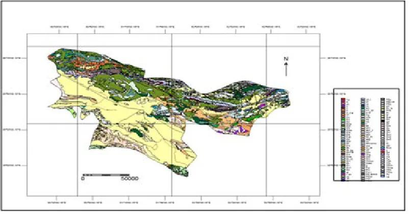
The watershed of Tehran province is located in the area of 13 geological zones: 1: 100000. Major digital maps produced by the Geological Survey could not be used for various reasons. For this reason, geological maps that were not digital were digitized by this company, and other digital maps taken from the Geoscience Database were modified and after merge the map Quaternary areas (Qal, Qt2, Qf2, Qt3 and Qf3) were selected and used in combination. (Fig. 1)
Fig. 1 . Geological map of Tehran province
Percent Area of prestigious arena
county name
3 36800
pakdasht
100 1203893
These areas cover about 33 percent (665469 hectares) of the total area of the province's watershed. Table 4 shows the area of land with suitable geological status in the province for countyof Pakdasht.
Table 4. Area of a prone field from the point of view of geology at the level of the county of Pakdasht
Percent Land area with favorable
geological status per hectare county name
7 46998
Pakdasht
100 654851
Total
Preparation of water surface layer and water quality of the province:
The groundwater map taken from the atlas of Iran's water resources Atlas of 1: 1000000 has been used for integration. The target area includes areas with good and generally good water quality and good, good, good, excellent, medium to good, and generally excellent, well, 34 percent (68421 ha) total area of the province's catchment area. Table 5 shows the area of land with suitable hydrogeology status in the province for countyof Pakdasht.
Table 5. Area of a prestigious arena from the point of view of hydrogeology at the level the county ofPakdasht
Percent Desirable land area
Hydro geologically per hectare county name
8 49681
Pakdasht
100 654251
Total
Integration of information and layers provided:
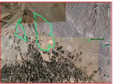
Finally, by combining the binary maps mentioned above, the land area suitable for flood spreading is about 4.2% of the total area (2001222 ha.) of the province's catchment area, which is about 84549 ha. of the total area of the area. According to The scale of the maps used in the areas below 100 hectares was eliminated. The total area of the land suitable for flood spreading is 78707 hectares. by integrating this map in county of Pakdasht of Tehran province, the area of favorable areas according to Table 6 was 10311 hectares(Table6 and Image 1).
Table 6. Areas prone to flood spreading in the area county of Pakdasht
Percentage of Totalarea Area - hectare
county name
13.1 10311
Pakdasht
100 78707
Whole province
REFERENCES
1. Abu-Taleb, M.F.2003. Recharge of groundwater through multi -stage reservoirs in a desert basin. Environmental Geology,44, 379 -390.
2. Bouwer, H. 2002. Artificial recharge of groundwater: hydrogeology and engineering. Hydrogeology Journal,10, 121-142.
3. Germezcheshmeh, Bagher et al., 2000. Survey of quaternary deposits for determining areas susceptible to flood spreading (A case study of north east of Isfahan), Master thesis, Faculty of Natural Resources, University of Tehran.in Persian.
4. Ghayoumian jafar, Shoaei z. Karimnejad H.R., GhermezcheshmehB.,Abdi P., 2002: some examples of artificial recharge of aquifers by floodwater spreading in Iran, proceedings of 9 thcongress of the
international association for engineering geology and the environment, Durban. South Africa,1529-1537
5. Hamed Panah, Ramin, 2000. Study of the proper location of flood spreading using satellite imagery and geographic information system, Master thesis, Faculty of Natural Resources, University of Tehran.in Persian
6. Kalantari, N., n. j., pawar., and M. R. keshavarzi.2009. Water Recourse Management in Intermountain IzehPlain,Southwest of Iran. J. MT.sci, 6,496-431 7. Kirshnomurthy J.,Kumar N., Jayaraman V., Manivel
M.,1996: An approach to demarcate ground water potential zones thorough remote sensing and a geographical information system, INT. J. remote sensing,vol. 17 , No. 10 1867-1884.
8. Kowsar. Ahang, 1994, Groundwater Watershed of the 4th Soil Science Congress, Iran Soil Science Association.in Persian
9. Mahdavivafa. H.,2016.Preparation of atlas for location of areas susceptible to floods in Tehran province.Agricultural and Natural Resources Research Center of Province Tehran.in Persian 10. Mohammadzadeh, Hossein, 1994. The role of
geological and hydrochemical studies of groundwater in the selection of flood spreading areas - A case study on the exploitation of KashmarBaharieh floods, Proceedings of the 2nd Iranian Geological Conference.in Persian
11. Ramalingam, M., Santhakumar, A.R., 1997: Case study on artificial recharge using remote sensing and GIS, internet.
12. Saraf, A. K., Choudhury P.R. 1998: Integrated remote sensing and GIS for ground water exploration and identification of artificial recharge sites, INT.J. Remote sensing, vol.19 No.10, 1825-1841.