ABSTRACT
Kuterdem, Can Ali. Integrated Watershed Management Using a Genetic Algorithm-Based Approach (Under the direction of Dr. Ranji S. Ranjithan)
BIOGRAPHY
Can A. Kuterdem is a graduate student in the Department of Civil Engineering at North Carolina State University in Raleigh, North Carolina, since August 1999. Mr. Kuterdem received a Bachelor of Science degree in the Environmental Engineering in June 1999 at the Middle East Technical University at Ankara, Turkey. He has been pursuing graduate course work and research in the area of Environmental System Analysis under the direction of Dr. S. Ranji Ranjithan.
TABLE OF CONTENTS
LIST OF FIGURES... iv
LIST OF TABLES ... iv
1. INTRODUCTION... 1
2. BACKGROUND... 3
3. THE STUDY AREA... 6
4. CASE STUDY SCENARIOS ... 11
4.1 WATERSHED MANAGEMENT STRATEGIES TO MINIMIZE TOTAL PHOSPHOROUS ... 12
4.1.1 MINIMIZING TP W/O POINT SOURCE CONTROLS ... 13
4.2 WATERSHED MANAGEMENT STRATEGIES UNDER URBAN DEVELOPMENT SCENARIOS ... 17
4.2.1 MAXIMIZING URBAN DEVELOPMENT TO MEET A TP TARGET OF 36,430 LBS/YR... 18
4.2.2 MAXIMIZING URBAN DEVELOPMENT TO MEET DIFFERENT TP TARGETS... 21
5. SUMMARY AND CONCLUSIONS... 23
LIST OF FIGURES
Figure 1
A schematic diagram of the optimization component within the STAR System for watershed management. Current implementation links the HSPF model
6
Figure 2 Yellow Creek Watershed 9
Figure 3 Land use allocation for minimizing TP w/o point source controls 15 Figure 4 Urban development when minimizing TP w/o point source controls 16 Figure 5 Minimum achievable TP at the outlet with varying PS treatment levels 17 Figure 6 Urban development under various point source treatment efficiencies at
the TP target of 36,430 lbs/yr 19
Figure 7 Land allocation for maximize urban land at TP target of 36,430 lbs/yr
under various treatment options 20
Figure 8 Tradeoff between point source treatment versus urban development and point source treatment versus water quality 22
LIST OF TABLES
Table 1 Land use allocations 10
1. INTRODUCTION
Traditionally, water quality problems in surface water systems have been addressed through managing point sources only. While controlling point source pollution has been successful in improving water quality in many cases, chronic water quality problems still exist. Non-point sources are more diffuse and are harder to identify, isolate, and control than point sources. It has been well documented that non-point source pollution such as nutrient runoff and atmospheric deposition contribute significantly to water quality problems (Jarrell 1999). Also, US EPA estimates that only 10 percent of impaired water bodies are attributed to point source pollution alone. Watershed scale management now requires an integrated approach that considers basin-wide water quality impacts of point and non-point source pollution and associated controls. This is reflected in US EPA’s requirement for development of a total maximum daily load (TMDL) and a plan to achieve it in impaired watersheds. Basin-wide TMDL development and implementations are required to ensure that the water quality of a given watershed will not deteriorate in response to growth or other anthropogenic uses. Although many advances have been made in computing technology and state-of-art water quality modeling, identifying proper pollution reduction strategies for watershed management still remains to be a daunting challenge for environmental managers. Numerous studies have been reported in the last decade that describe improvements to methods and tools for watershed management (e.g., Yeh and Labadie, 1997; Cox and Madramootoo, 1998; Gu and Dong, 1998; Dupont et. al., 1998; Mailhot et. al., 1998; Chen et. al., 1999; Coburn, 1999; Xinhao et. al., 2000).
and Soil and Water Assessment Tool (SWAT) (Arnold, 1997). Although BASINS facilitates specification of alternative pollutant loading scenarios and evaluation of resulting water quality, the search for good management strategies that specify pollutant reduction allocations among the sources and the associated need for best management practices (BMPs) requires a trial-and-error approach. In addition, systematic consideration of other implications, most importantly the costs of watershed-scale pollution reduction strategies, is not supported.
Mathematical modeling is used to represent the search problem for which the solution characterizes a feasible set of decision variable values that meet the objectives and constraints embedded in the model. Depending on the structure of that model and the types of functions used to describe the problem, different solution approaches, or algorithms, are used to determine the optimal solution. The watershed management problem can be represented via such a model, which requires representation of the pollution transport and chemical transformation processes that are typically non linear. Further, any realistic watershed management problem has a large number of feasible solutions, making trial-and-error search procedures inefficient. Systematic search via a formal algorithm is needed. The nature of the mathematical functions used to define this problem generally renders traditional search algorithms poorly applicable. Emerging contemporary optimization procedures, such as genetic algorithms (GA's), simulated annealing (SA), ant colony algorithm, and particle swarm optimization, offer alternative means for solving optimization models that are inherently discontinuous and non-linear (Michalewicz, 1996). These heuristic techniques allow integration of the complex simulation models that include nonlinear and discontinuous relationships directly into the optimization process. In the case of watershed management, a comprehensive water quality model like HSPF could be used instead of relying on their reduced-form mathematical representations. Several studies describe the utilization of such search algorithms for solving environmental management problems (e.g., Harrell and Ranjithan, 1998; Matthews et. al., 1999; Murray, 2000; Loughlin et. al. 2000).
procedure forms the primary engine of the STAR system. This is coupled with additional tools, including an uncertainty propagation tool, solution reporting system, and an incremental strategy development system, to form a highly interactive decision support framework. The STAR system facilitates a systematic approach for developing watershed management strategies for point and nonpoint source controls to meet specified watershed-scale water quality targets while enabling consideration of cost and uncertainty. Murray (2000) demonstrated the applicability of the STAR system in developing TMDL’s through a realistic illustrative case study. The focus of this study was identifying appropriate future land use allocations with nonpoint source controls for the Suwanee Creek watershed in Gwinnett County, Georgia under different water quality targets. The point source control capabilities were not explored or tested. The purpose of the work presented in this paper is to demonstrate the applicability of the STAR system in studying a realistic watershed management problem that requires the consideration of both point and nonpoint source controls. Data from a recent EPA TMDL study for the watersheds in the Gwinnett County, Georgia were used to construct an array of illustrative watershed management scenarios, which are then solved using the capabilities of the STAR system.
2. BACKGROUND
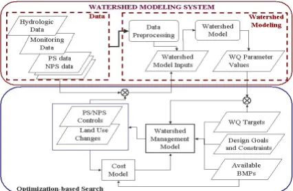
In this study, STAR’s GA-based search capabilities along with the GUIs for problem definition and solution display, as well as the incremental strategy development capabilities, were utilized. The GUIs enabled the definition of the range of watershed management scenarios that considered nonpoint source control via riparian buffer strips, multiple instream water quality parameters, and changes in land use allocation to accommodate growth. The general structure of the search (optimization) procedure is shown in Figure 1. The HSPF model was coupled with this search procedure to determine the water quality parameter values.
HSPF is a continuous, lumped parameter model, which simulates the hydrology over pervious and impervious land segments, and the physical and chemical processes within a stream (Bicknell, 1997). HSPF consists of three types of zones: pervious land segments (PERLND), impervious land segments (IMPLND), and reaches (RCHRES). Each zone produces outflow, which is evaluated at a node. The area between two nodes is defined as a reach (Bicknell, 1997). Runoff and pollutant loading from the land area in each reach is attributed to the corresponding node. Each reach has inflows from the associated land segments and any upstream reaches. The processes modeled within the reach affect outflows from a reach. HSPF usually models long continuous simulations, sometimes over a few years, although it is capable of simulating storm events.
different point source control scenarios can be simulated to study their impacts on water quality.
Coupling of HSPF with a systematic search procedure as shown in Figure 1 allows the user to define an array of water quality and land use development goals. For example, values of pollutant concentrations modeled within HSPF can be minimized or the area of urban land use types can be maximized. Constraints can also be imposed to achieve required water quality or development targets, enabling the user to examine tradeoffs among competing objectives. For example, water quality can be constrained to a desired level while determining the maximum allowable development in a watershed. Alternatively, constraints can be imposed to limit the amount and type of development, either for any subwatershed, or for the entire watershed. The first type of land use constraints can be used to restrict conversion of an area from one type of land use to another. For example, the user may prevent development in any natural wetlands. The second type of land use constraints can be used to prevent unreasonable growth or depletion of a certain land use. For example, urban land in the future development plan may be limited to a maximum percentage of the watershed. Similarly, constraints can be imposed on point source controls to ensure a certain level of reduction in discharge at any point source.
Figure 1 – A schematic diagram of the optimization component within the STAR System for watershed management. Current implementation links the HSPF model.
3. THE STUDY AREA
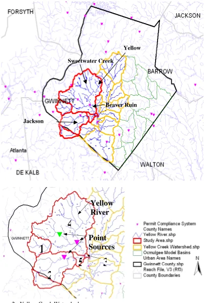
The study area includes the drainage basin covering the Northwest portion of the Yellow River system starting from Beaver Ruin Creek and extending to Sweetwater Creek, Jackson Creek (Dekalb Co.) till Jackson Creek at Arcado Rd. (Figure 2). The study by TetraTech, Inc. calibrated the HSPF model for flow, temperature, sediments, dissolved oxygen, biochemical oxygen demand, nutrients and metals. The calibration data was based on monitoring information for the period January 1993 to December 1998. The study area includes approximately 44,460 acres (68 square miles) located northeast of metropolitan Atlanta, and it is subdivided into five sub basins. Three point sources are located within these five sub basins (Figure 2).
Although the model characterizes an array of pollutants, the current study focuses on TSS and total phosphorous (TP), the pollutants for which TMDL development is currently underway. Based on recent studies, a loading rate of 1,600 lbs/ac/yr of TSS in each sub basin has been identified as an acceptable target to meet desired TSS levels in the stream. Although no specific loading rate for TP is set yet, the goal is to minimize the TP loading as well as to study the variation of TP loading with different urban growth levels.
To represent the non point source loading from the land cover in the basin, the study area was characterized by 17 different land use types (Table 1). The data for this characterization was produced from the 1995 ARC land use coverage and the 1997 Gwinnett County land use coverage developed by Gwinnett DOT (Tetra Tech, Inc., 1999). In the illustrative study presented in this paper, land use types of similar characteristics were grouped together to form a reduced set of eight land types (Table 1). Two new land use types were also introduced to represent future urban areas (namely high density residential and office parks) with buffer strips as BMPs for nonpoint source control. In all scenarios analyzed here, urban development is represented by the sum of the acreages allocated to the following land use types: high-density residential, low-density residential, office parks, roads, high-low-density residential w/ buffer and office parks w/ buffer. Table 1 shows the original acreages of the land uses in each subwatershed as well as the total acreages at the watershed level.
Figure 2 - Yellow Creek Watershed
Beaver Ruin Sweetwater Creek
Jackson
Yellow
Yellow
River
Point
Sources
4
1
5
3
4. CASE STUDY SCENARIOS
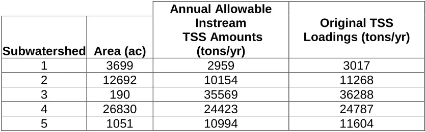
As stated in the Gwinnett County Watershed Protection Plan, development is expected in residential and commercial sectors within the next 20 years. It is evident that development and growth have adverse effects on the water quality due to increase in point and non-point source loadings. Scenarios were constructed to identify point and nonpoint source pollution control strategies that would facilitate increased urban development while meeting the water quality goals in the watershed. As TSS in the Yellow River watershed is already identified as a critical pollutant and associated loading targets have been set, the scenarios analyzed here were constrained to meet those targets. The recent Watershed Protection Planning study specifies a countywide TSS loading target of 1600 lbs/ac/yr. The corresponding in-stream allowable TSS amounts at the outfall of each subwatershed were estimated using the calibrated HSPF model (Table 2). When calculating the allowable amounts within a subwatershed, the loading associated with drainage from upstream subwatersheds into that watershed is appropriately added. As an example, subwatershed 1 in the study area contributes to the annual sediment loading at the outlet of the subwatershed 4. Thus, the TSS target for the subwatershed 4 is calculated by accounting for the TSS loading from the contributing areas in subwatersheds 1 and 4. A comparison of current and allowable TSS amounts (Table 2) indicates that reductions in TSS loadings are necessary. In the following scenarios, these allowable instream TSS amounts were imposed as constraints when identifying point and nonpoint source control strategies.
Table 2 - Current and allowable instream TSS amounts
Subwatershed Area (ac)
Annual Allowable Instream TSS Amounts (tons/yr) Original TSS Loadings (tons/yr)
1 3699 2959 3017
2 12692 10154 11268
3 190 35569 36288
4 26830 24423 24787
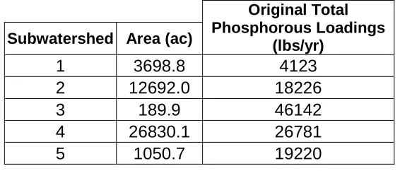
Although no specific TP loading target is identified for this watershed, it is assessed that current loadings (Table 3) are higher than what could be sustained at downstream locations. The scenarios described in the following sections attempt to improve upon current loading rate and minimize TP loading at the outfall of the study area, i.e., at the outlet of subwatershed 3, from future urban development. These scenarios are also used to examine the tradeoff among urban development, TP loading, and point and nonpoint source reductions. Buffer strips as BMPs in new urban areas and treatment technologies to reduce point source loadings are considered.
Table 3 - Current instream total phosphorous amounts
Subwatershed Area (ac)
Original Total Phosphorous Loadings
(lbs/yr)
1 3698.8 4123
2 12692.0 18226
3 189.9 46142
4 26830.1 26781
5 1050.7 19220
4.1 Watershed Management Strategies to Minimize Total Phosphorous
(as shown in Table 2) were also imposed. Maximum treatment efficiencies at the point sources were set at the following discrete levels: 0%, 30%, 60%, and 90% reduction.
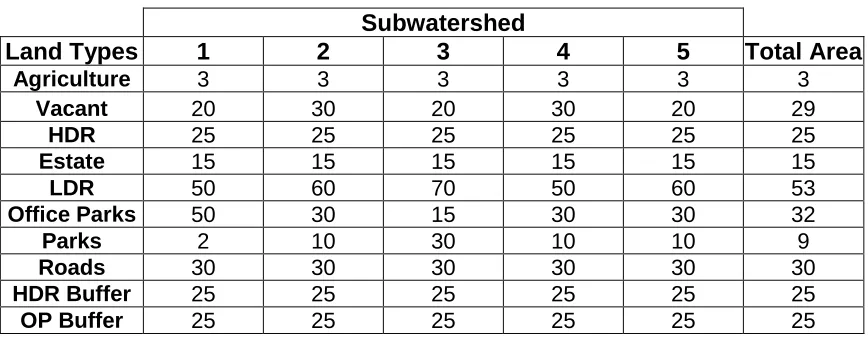
Table 4 - Allowable maximum percentages of land use development Subwatershed
Land Types 1 2 3 4 5 Total Area
Agriculture 3 3 3 3 3 3
Vacant 20 30 20 30 20 29
HDR 25 25 25 25 25 25
Estate 15 15 15 15 15 15
LDR 50 60 70 50 60 53
Office Parks 50 30 15 30 30 32
Parks 2 10 30 10 10 9
Roads 30 30 30 30 30 30
HDR Buffer 25 25 25 25 25 25
OP Buffer 25 25 25 25 25 25
4.1.1 Minimizing TP w/o Point Source Controls
Table 5 - Land use allocation for minimizing total phosphorous
Original Allocation Land Use Allocation for Minimizing TP w/o Point Source Controls
Land Type
Acreage of Watershed
Area
Percent of Watershed
Acreage of Watershed Area
Percent of Watershed
Percent Change
Agriculture 87 0 43 0.1 -51
Vacant 9764 22 9706 21.8 -1
HDR 1761 4 1282 2.9 -27
Estate 3332 8 2815 6.3 -16
LDR 14793 33 7957 17.9 -46
Office Parks 7780 18 6715 15.1 -13
Parks 1118 3 874 2.0 -22
Roads 5827 13 5874 13.2 1
HDR Buffer 0.0 0.0 5269 11.9 NA
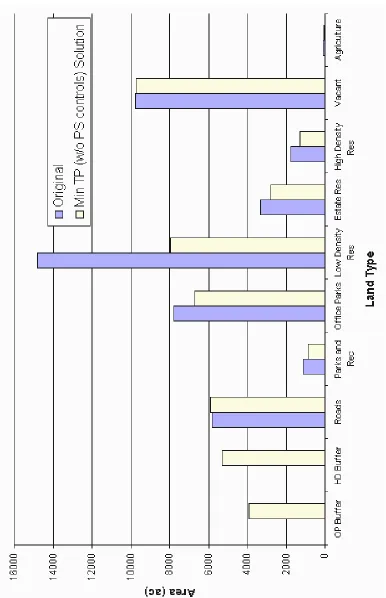
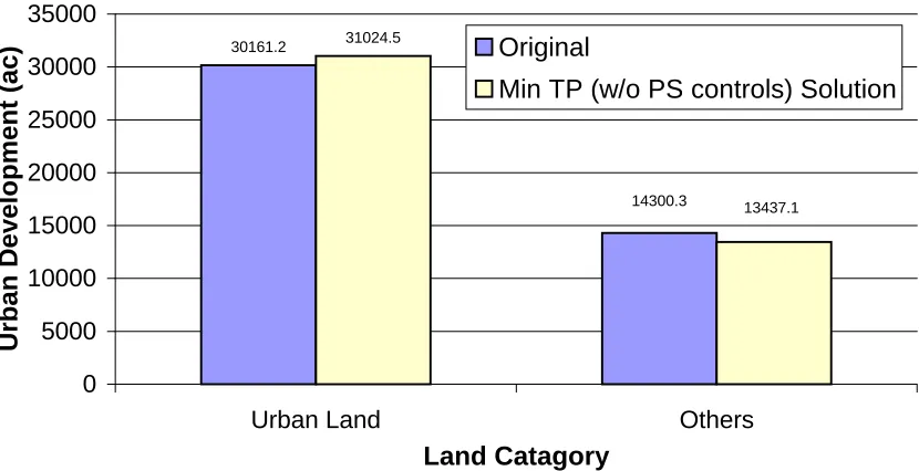
30161.2 31024.5 14300.3 13437.1 0 5000 10000 15000 20000 25000 30000 35000
Urban Land Others
Land Catagory U rban D evelopment ( ac) Original
Min TP (w/o PS controls) Solution
Figure 4 - Urban development when minimizing TP w/o point source controls
4.1.2 Minimizing TP with Point Source Controls
Figure 5 - Minimum achievable TP at the outlet with varying PS treatment levels
4.2 Watershed Management Strategies under Urban Development
Scenarios
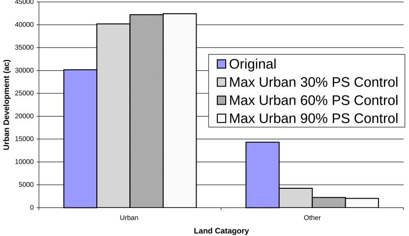
To provide insight into how much urban development could be allowed and how that affects TP at the outfall, a series of scenarios was defined. In these scenarios, while ensuring the TSS targets and land use conversion constraints, the urban areas are maximized under varying point source control levels and TP amount at the outfall. Land types that contribute to the urban category are high-density residential, low-density residential, office parks, roads, high-density residential with buffer and office parks with buffer. Using the results from the results discussed in Section 4.1, discrete TP levels, as shown in Figure 5, were used to define different scenarios. Similarly, the point source control levels were set at different discrete levels (30%, 60% and 90% treatment efficiencies). Different combinations of these discrete levels were used to define different
30278 28215 33098 36430 46142 0 5000 10000 15000 20000 25000 30000 35000 40000 45000 50000
Original Min TP w/o PS control Min TP 30% PS Control
Min TP 60% PS Control
Min TP 90% PS Control
Scenario Name
models, and their solutions describe the tradeoff between urban development and TP amount at the outfall.
4.2.1 Maximizing Urban Development to Meet a TP Target of 36,430 lbs/yr
In this scenario, urban development plans at different point source treatment levels were identified, and the results are summarized in Figure 6. As indicated by the tradeoff in these results, the rate of increase in urban development with increasing point source treatment levels diminishes.
Figure 6 - Urban development under various point source treatment efficiencies at the TP target of 36,430 lbs/yr
0 5000 10000 15000 20000 25000 30000 35000 40000 45000
Urban Other
Land Catagory
Urban Devel
opm
ent (ac)
Original
4.2.2 Maximizing Urban Development to Meet Different TP Targets
5. SUMMARY AND CONCLUSIONS
This paper presents an application of the STrategy, Analysis and Reporting (STAR) system to an illustrative but realistic case study for the Yellow River Watershed in Gwinnett County, Georgia. Two sets of scenarios were studied to demonstrate the applicability of the STAR system to integrated watershed management. While TSS targets are well established for this watershed, no phosphorous target is yet specified. Thus, the first set of scenarios focused on identifying the best total phosphorous levels that could be achieved at the outlet of the watershed. This was explored by considering point and nonpoint source control options. As Gwinnett County expects to grow in the next 20 years, another set of scenarios were designed to identify future growth and associated land use allocation plans that meet water quality targets. These scenarios help determine the tradeoff between future urban development and TP levels. Again, point and nonpoint source controls were applied at varying levels in generating this tradeoff information. The incremental strategy development capabilities of the STAR system was also applied to examine selected solutions and to identify alternatives.
The results indicate that considerable improvement in TP levels could be achieved while meeting current targets on TSS. The degree of improvement in TP levels from different levels of point source controls, as well as nonpoint source control via requiring buffer strips for new urban land areas, are characterized. The set of tradeoff curves generated in this study provides rich information on how to achieve different urban development levels via different degrees of point source treatment, as well as on how to achieve a specific TP level through urban development management at different point source treatment levels. Such information that is made possible by employing the capabilities of the STAR system can assist a user in exploring alternative strategies and in understanding the available choices in watershed management.
further manual trial-and-error search, enabling an iterative watershed management decision-making process.
6. REFERENCES
1. Arnold, J.G., et. al., (1997). “Soil and Water Assessment Tool, User’s Manual.” USDA Agricultural Research Service (ARS)
2. Bicknell, B. R., et al. (1997). “Hydrological Simulation Program – Fortran, User’s Manual for version 11”. US Environmental Protection Agency, National Exposure Research Labaratory, Athens, GA., EPA/600/R-97/080
3. Chen C. W., Herr J., Zimelis L., Goldstein R. A., Olmsted L. (1999), "Decision Support System for Total Mazimum Daily Load", Journal of Environmental Engineering -ASCE, 125 (7): 653 - 659.
4. Coburn J.(1999), "Integrated watershed Management On the Truckee River in Nevada", Journal of the American Water resources Association, 35 (3): 623-632.
5. Cox C., Madramootoo C. (1998), "Application of Geographic Information System in Watershed Management Planning in St. Lucia", Computers and Electronics in Agriculture, 20: 229-250.
6. Dupont J, Smitz J, Rousseau A. N., Mailhot A, Gangbazo G (1998), "Use of Digital Decision Support System Tools for Water Management", Journal of Water Science, 11: 15-18.
7. Dorn, J. L., C. A. Kuterdem, S. K. Chetan, T. L. Murray, A. V. Parandekar, A. Whangbo, and S. Ranjithan, (1999). "BASINS-STAR: An Evolutionary Algorithm-based Decision Support Framework for Watershed Water Quality Management," In Proceedings of the 2001World Water and Environmental Congress, May 20-24, Orlando, FL (8 pages)
8. Gu R., Dong M. (1998), "Water Quality Modeling in the Watershed-Based Approach for Waste Load Allocations", Water Science and Technology, 38 (10): 165-172.
10.Jarrell, Wesley M., (1999). “Getting Started with TMDLs.” Oregon Graduate Institute of Science and Technology.
11.Lahlou, M. L., Shoemaker, S., Choudhury, R., Elmer, A., Hu, H., Manguerra, Parker, (1998), “Better Assessment Science Integrating Point and Nonpoint Sources, Version 2.0” US EPA, Office of Water (4305), EPA-8230B-98-006
12.Loughlin, D. H., Ranjithan, S. R., Baugh, J. W., Brill, E. D., (2000), “Application of Genetic Algorithms for the Design of Ozone Control Strategies”, Journal of Air & Waste Management Association, vol 50: 1050 – 1063.
13.Mailhot A., Rousseau A., Massicotte S., Dupont J., Villeneuve, J-P. (1997), "A Watershed Based System for the Integrated Management of Surface Water Quality: The GIBSI System", Water Science and Technology, 36 (5): 381 - 387.
14.Matthews, K. B., Sibbald, A. R., Craw, S., (1999). “Implementation of a Spatial Decision Support System for Rural Land Use Planning: Integrating Geographic Information System and Environmental Models with Search and Optimization Algorithms”, Computers and Electronics in Agriculture, vol: 23: 9-26
15.Michalewicz, Z. (1996), Genetic Algorithms + Data Structures = Evolution Programs, Springer - Verlag, New York.
16.Murray, T. L. (2000) “Application of the Water Quality Management Decision Support System (WQMDSS) in an Illustrative Watershed Management Study”. MS Thesis, Department of Civil Engineering, North Carolina State University
17.Parandekar, A. V. (1999) “Development of a Decision Support Framework for Integrated Watershed Water Quality Management and a Genetic Algorithm Based Optimizer”. MS Thesis, Department of Civil Engineering, North Carolina State University
18.Tetra Tech, Inc., and CH2M Hill, (1999). “Gwinnett County Watershed Assessment and Modeling Study Watershed Model Calibration Technical Memorandum.” Prepared for Gwinnett County by Tetra Tech, Inc. and CH2M Hill.
19.Xinhao W., Charlotte W. H., Scott D., Ying Y. (2000), "GIS - ROUT: A River Model for Watershed Planning", Environment and Planning B: Planning and Design, 27 (2): 231-246.