Spatial Technology based Environmental
Modelling for Waste Land Development in
Sirsiya Block (Baraich District, India)
Surendra Kumar Yadav
Associate Professor, Department of Applied Sciences, Sir Chhotu Ram Institute of Engineering & Technology, Chaudhary Charan Singh University, Meerut, UP, India.
ABSTRACT: Environmental modelling using spatial technology (GIS, RS & GPS), as platform, can support many database queries tied to spatially referenced object and their associated attributes in waste land reclamation and management. Waste lands, which are marginally suitable area in open forest, found after analysis and modeling in GIS as 33.37 sq. km. This waste land area can be developed by considering basic needs like energy and biomass for local community members. Genesis of wasteland and their typologies into degraded forests, undulating land, gullied and ravinous land, degraded pastures, waterlogged, salt-affected and sand-affected areas etc. have been mapped and analyzed with special reference to their relationship to natural environment, other land uses, human response and the problems and potentialities for reclamation. Action plan was developed for management and development of waste lands into forest cover to achieve sustainability.
KEYWORDS:waste land, GIS, modelling, degraded forest, ecosystem management.
I. INTRODUCTION
Approximately 175 million hectares of land is degraded India has total 329 million hectares (mha) of land. The extent of land under agriculture is 143 mha & again 56% of this suffers from varying degrees of degradation. Land degradation is a composite term describing the aggregate diminution of productive potential of land. A degraded land may be productive for another aspect e.g. as an economic resource, depending upon site but this is not true for degraded soil. Average fertile top soil composition by volume is: mineral-45 % plus organic matter-5 % makes solid portion; and air- 25 % plus water- 25 % constitute pore space [1]. Soil is supposed to have increased reflectance between 0.4 to 1.1 micro- meter wavelengths [2]. Land and soil degradation processes are site specific. So, it is essential to characterise and map the degraded areas because of site-specific development [3] and management plans could be made. Ecosystem functions are affected broadly due to all human activities.
Remote Sensing (RS) Applications coupled with Geographic Information System (GIS) is extremely useful in the decision and solution [4] for environments management. The application areas for remotely sensed data are both wide and varied [5]. Radiometric data potentially represent a very useful source of information in pedological research and land use pattern [6]. Ready and timely availability of satellite observations of existing land use pattern from various remote sensing satellites now provide a most cost-effective means of identification of different forms of land, status of water resources, quantification of soil moisture content and soil degradation to enable all nations to take appropriate measures for maintaining productive use [7] of environments. An environment may be related topologically with wastelands or forest ecosystems [8-10]; and may be affected by industrial pollution and consequently this may interfere indirectly with community people [11] living in nearby surrounding area and their economic status [12]. Remote Sensing coupled with Geographical Information System (GIS) can be extremely useful [13] for environment management. Soil is basic requirement for maintenance of biodiversity [14].
lake of water resources, desertification, salinization, and biogeochemical endemic diseases etc. occur in fragile regions of the environment [16]. Hence, there is an urgent necessity of systematic inventory, mapping and monitoring of land resources [17-18] leading to an ecological balance in an area. The digital data can be used to map various types of wasteland. The spatial distribution and soil nature of these lands can serve as the base for the implementation of various reclamation measures and afforestation programmes [19-20]. Proper monitoring and planning, through spatial technology, leads to management of natural resources and ecosystem for sustainable development [21]. Spectral signatures of water, agricultural land, forest, wasteland etc. differ from each other distinctly [22]. Environmental protection and ecological balance are essential to ensure that development is sustainable in the long run [23]. The physiography, hydrology and chemical characteristics of soils are greatly responsible for the various kinds of land-degradation hazards [24]. Any major disaster affects a wide range of sectors of a society which can include political, social, cultural, environmental, physical, technological and economic aspects [25]. The spectral behaviour of each unit varies according to the nature and percent cover [26]. The characteristics of the pictures reflected on the remote sensing images are formed mainly by the difference in information of the tone and the form characteristics [27].
II. RELATEDWORK
Various types of remote sensing data, such as, SAR, MSS, TM, ETM, MOMS, AVHRR and SPOT etc. lave been used for earth resources management and development of semi-arid regions by various governmental agencies, institutions, and universities of the world. Remote sensing and GIS are economic and adequate for the land survey and land use classification of semiarid regions of Paraiba state of Brazil [28]. Digital image analysis of Landat-TM data in eastern Connecticut for regional land use and land cover classification [29] can provide better visualization of the environment. The results were found most satisfactory for regional planning in the state of Connecticut. ERDAS Imagine Software and SPOT data is a good combination for land use and land cover mapping in order to develop the region of the Paraiba sate of Brazil [30-32]. GIS system can be extremely useful for land use planning and management of semi-arid regions of northeastern Brazil, using digital image processing on Landsat-TM and SPOT data [33]. Supervised classification for the soil and land use studies for a part of semiarid regions of Brazil [34] and comprehensive work for land use planning in semi-arid regions of NE Brazil, using SPOT HRV data were analyzed in details [35-36].
Wasteland means degraded land which can be brought under vegetative cover with reasonable efforts, and which is currently under-utilized, or land which is deteriorating due to lack of appropriate water and soil management or on account of natural causes [37]. About 16 per cent of the country’s geographical area is under wastelands [38]. Information on geographical location, aerial extent and spatial distribution of wastelands is essential for their effective management and sustainable development [39]. The plains of north Bihar in eastern India have recorded the highest number of floods in India in the last 30 years [40]. In India, an estimated 2.46 Mha of land is reported to have suffered from water logging [41]. India is estimated to have about 58.2 million hectares of wetlands [42] many of which are distributed around the Indo-Gangetic plains. Generally regarded as ‘‘a water-surplus area’’ [43] the entire region is characterized by palaeo- levees, swamps or flood basins locally called ‘‘Chaurs’’ relict palaeo- channels aggraded to different extents, meander belts, ox-bow lakes, and cut-off loops. Space borne multispectral data, by virtue of providing synoptic views of fairly large areas at regular intervals, have been found to be very effective in providing the necessary information on salt-affected soils and waterlogged areas in a timely and cost-effective manner [44-46].
III.METHODSOFINVESTIGATION
Methodology in waste land development and management using remote sensing & GIS is more or less same but many time variable and parameters are different and data set may vary from one place/ habitat to other and for different ecosystems. Methodology followed (in case of waste land development by management of degraded forest ecosystem in Sirsiya Block, Bharaich District, India) include: (i) preparation of base-map from Survey of India topographical sheet; (ii) visual interpretation of Satellite data/ Imagery to study the various aspects of environment like biogeological aspects, vegetation, geology, urban-sprawl, hydromorphogeology, structural features and land use of the area; (iii) digital enhancement of Remote sensing data for delineating vegetation, geomorphic and structural elements; (iv) correlation of digital enhanced Remote sensing data with other data; (v) preparation of vegetation anomaly map, hydromorphogeological & land-use maps from satellite imagery for study of vegetation aspects, land degradation aspects, groundwater potentiality and change in recharge capacity by changed land-use patterns; (vi) imposition of interpreted Remote Sensing data on base-map; (vii) soil samples' analysis to estimate fertility aspects; (viii) field traverses for sample collection of soil, water & chlorophyll data using guide map and analysis; (ix) analysis and modelling in GIS; (x) application of GIS based approach for planning & management of waste land development to take decision as per action plan.
IV.MODELLINGINGIS
In Analysis/ modelling, equation and syntax used in GIS (INTERGRAPH) for different overlays is: Output = select{i1=1,1,0}+ select{i2=2,2,0}+select{i3=3,3,0}+ select{i4=4,4,0}+---, where i is input and 1,2,3,4, --- N represents number of layers overlayed. Analysis and overlaying steps for open degraded forest area were done in following steps: Step-1: Open forest map Vs. Ground water potential map; Step-2: Step 1 Vs. Soil texture map; Step-3: Step 2 Vs. Soil fertility map; Step-4: Step 1,2 and 3 repetition for various combinations. Final output was obtained in the form of required manner and combinations as per objectives of research problem for action plan to implement.
V. OUTPUTOFANALYSIS
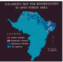
Figure 1: GIS based dynamic map indicating waste lands (open degraded forest) development/ management plan. Red, pink and blue colours are used to depict waste lands for development as highly suitable, moderately suitable and marginally suitable respectively.
VI. CONCLUSION
Spatial patterns and variations of different attributes relating to landform, land use, wasteland and demographic characteristics and their spatial association are brought out in the study. Spatial technology (Remote Sensing or RS, Geographical Information System or GIS and global positioning system or GPS) opens ways for better monitoring, planning, development and management of waste land development in sustainable manner. For open degraded forests (crown density 10-40%), which includes waste lands, following species are recommended : (i) to increase the crown density, species like Tectona grandis, Shorea robusta, Teminalia tomentosa, Bombax cieba, Bahunia perviflora, Adina cordifolia, Cassia fistula etc. are suggested; (ii) to meet the requirement of fuel and fodder of the nearby local people, species like Su babul, Prosopis juliflora, Dalbergia sissoo, Albizzia species, Acacia species and Ziziphus species are suggested in the outside notified forest areas; (iii) Eucalyptus, Poplar etc. are in great demand for pulp and paper and match box industries. So these species are suggested in suitable areas within the notified and non- notified areas for waste land development. GIS can handle huge data sets (spatial & non-spatial data).
REFERENCES
[1] Yadav, S. K., “Management of Degraded Soil for Sustainable development using Remote Sensing and GI S Techniques in South Delhi Region (India)”, Unpublished PhD Thesis, submitted to the Jawaharlal Nehru University, New Delhi, India, 1997.
[2] Prasad, C. R. S., “Use of Landsat imagery for mapping soil and land resources for development planning in parts of northern Karnataka, India”, International Journal of Remote Sensing, V o l .11, No. 10, pp. 1889-1900, 1990.
[3] Raina, P., “Assessment of soil degradation hazards in Jalor and Ahor tehsil of Jalor District (Western Rajasthan) by remote sensing”, J. Indian Soc. Remote Sensing, Vol.22, No. 3, pp. 169-181, 1994.
[4] Yadav, S. K., “Soil Ecology”, APH Publishing House, New Delhi, India, 2007.
[5] Leone, A. P., Wright, G. G. and Corves, C., “The application of satellite remote sensing for soil studies in upland areas of Southern Italy”, Int. Jr. Remote Sensing, Vol.16, No. 6, pp. 1087-1105, 1995.
[6] Chattopadhyay, S., and Chattopadhyay, M., “Application of remote sensing in terrain analysis - A case study of the Wayanad Plateau, Kerala, India”, Int. Jr. Remote Sensing, Vol.10, No. 6, pp. 1075-1084, 1989.
[7] Zhi, D., “The application of remote sensing technology to natural resource investigation in semi-arid and arid regions”, Symposium on Remote Sensing for Resources Development and Environmental Management / Enschede, pp. 419-424, 1986.
[8] Yadav, S. K., “Remote Sensing Technology based approach in Air Resource Management for Ecosystem Development”, International Conference on Ecological Engineering, held at University of Kalyani, West Bengal, India, 1998.
[9] Yadav, S. K., “GIS Applications in Development & Management of open degraded forest & waste land in Sirsiya Block, Bahraich, UP, India”, A project report submitted to IIRS, Deptt. of Space (Government of India), Dehradun, India, 1997.
[10] Yadav, S. K., “Applications of Remote Sensing & GIS Technology in Protection, Development and Management of Medicinal & Aromatic Plants”, National Seminar on Recent advances in Medical & Aromatic Plants, held at SVB Patel University of Agriculture & Technology, Meerut, India, 2005.
[11] Yadav, S. K., “Environmental Pollution by Pulp & Paper Industry and Community Health- A case study”, National Conference on Environment and Health in India, held at Banglore, India, 2001.
[12] Yadav, S. K., “Economic & Health Improvement of Rural community through Waste land Development using GIS Technology: A case study”, National seminar on GIS Applications in Micro level Planning, held at NIRD, Hyderabad, India, 2002.
[13] Yadav, S. K., “Ecosystem Management through air Conservation in Urban Environment using Remote Sensing data”, Indian Journal of Environmental Protection, Vol.22, No.10, pp. 1155-1161, 2003.
[14] Christensen, N. L., “Fire Ecology”, Encyclopedia of Environmental Biology, Academic Press, Vol.2, 1995.
[15] Sloggett, D. R., and McGeachy, C., “EARTHSCAN - A range of remote sensing systems”, Symposium on Remote Sensing for Resources Development and Environmental Management / Enschede, pp. 167-171, 1986.
[16] Howe, H. F., “Succession and fire season in experimental prairie plantings”, Ecology, Vol.76, No.6, pp. 1917-25, 1995.
[17] Jie, T., and Nianfeng, L., “Some problems of ecological environmental geology in arid and semi-arid areas of China”, Environmental Geology, Vol.26, pp. 64-67, 1995.
[18] Lutz, E., Pagiola, S., and Reiche, C., “The cost and benefits of soil conservation: The farmer’s viewpoint”, Research Observer, Vol.9, No.2, pp. 273-295, 1994.
[19] Girard, C. M., “Spectral and botanical classification of grasslands: Auxois example”, Symposium on Remote Sensing for Resources Development and Environmental Management / Enschede, pp. 269-272, 1986.
[20] Yadav, S. K., “Sustainable Air resource Management in local urban environment using satellite data: a case study”, International conference on Ground water vulnerability assessment & Mapping, held at Ustron, Poland, 2004.
[21] Kale, P., “Sustainable development - Critical issues”, J. Indian Soc. Remote Sensing, Vol.20, No.4, pp. 183-186, 1992.
[22] Openshaw, S., Wymer, C., and Charlton, M., “A geographical information and mapping system for the BBC Domesday optical disks”, Trans. Inst. Geogr. N.S, Vol.11, No. 3, pp. 296 -304, 1986.
[23] Rao, U. R., “Remote sensing for sustainable development”, J. Indian Soc. Remote Sensing, Vol.19, No.4, pp. 217-235, 1991.
[24] Okalebo, J. R., Gathua, K. W., and Woomer, P. L., “Laboratory Methods of Soil and Plant Analysis: A Working Manual”, Marvel EPZ (Kenya) Ltd., Nairobi, Kenya, 1993.
[25] Scholten, H. J., Bijtelaar, B., “GIS and Multi media: how to integrate”, Technical aspects of a prototype, Workshop on Multimedia and GIS, CNIG, Lisboa, 1993.
[26] Furst, J., Girstmair, G., and Nachtnebel, H. P., “Application of GIS in Decision Support Systems for Ground Water Management”, Proceedings of HYDROGIS, IAHS Publication, Vienna, No. 211, 1993.
[27] Central Ground Water Board Repot., “Ministry of Water Resources, Govt. of India (Unpublished Report)”, 1993.
[28] Silvajunior, E.B., “Avaliação muititemporal da atividade antrópica na região de Santa Luzia-PB com o uso de Geoprocessament, Areia: UFPB”, M.S. Thesis, pp. 66, 2000.
[29] LaBash, C. L., Civco, D. L., and Kennard, W.C., “The use of linearly transformed Landsat Thematic Mapper Data in land use and cover classification”, Technical Paper, ASPRS/ACMS Annual Convention, Baltimore, Marryland (USA), Vol.2, pp. 53-66, 1989.
[30] Ribeiro, G. N., “Mapeamento do Uso da Terra e Cobertura Vegetal em Área do Agreste Paraibano, utilizando Técnicas de Sensoriamento Remoto e Geoprocessamento, Areia: UFPB”, Dissertação de Mestrado, pp. 93, 2006.
[31] Anderson, J.R., Hardy, E. E., Roach, J. T., and Witmer, R. E., “A Land Use and Land Cover Classification system for Use with Remote Sensing Sensor Data”, U.S. Geological survey Professional Paper No.964, pp. 28, 1976.
[32] ERDAS 7.5, “Field Guide”, 1991.
[34] Teotia, H. S., Teotia, S., Ulbricht, K. A., and Reinartz, P., “Relevance of MOMS-02 in developing Countries´s future programs of natural resources, cultural resources and environmental resources information management”, ECOINFORMA, Lake Buena Vista, Florida (USA), 1996.
[35] Kennard, W.C., Teotia, H.S., and Civco, D.L., “The Role of an automated GIS in the development and management of renewable natural resources of northeastern Brazil”, XVI ISPRS Congress, Kyoto, Japan International Archives of Photogrammetry and Remote Sensing, Vol.27, No.89, pp. 220-231, 1988.
[36] Teotia, H.S., and Ulbricht, K.A., “The Integration of Remote Sensing and GIS Technologies for Land Development and Irrigation Potential in the State of Cerara, NE Brazil”, ISPRS General Convention, Washington, D.C. Intl. Arch. Photogrammetry and Remote Sensing XXIX, Comm. VII, pp. 466- 472, 1992.
[37] Saha, S.K., Kudrat, M., and Bhan, S.K., “Digital processing of Landsat TM data for wasteland mapping in parts of Aligarh District (Uttar Pradesh), India”, “International Journal of Remote Sensing”, Vol.11, No.3, pp. 485-492, 1990.
[38] Jaga, N., Sundaram, A., and Natarajan, T., “Wasteland development using Geographic Information System techniques, “International Journal of Remote Sensing”, Vol. 14, No. 17, pp. 3249-3257, 1993.
[39] Gautam, N.C., and Narayan, L.R.A., “Wastelands in India”, Pink Publishing House, Mathura, India, pp. 96, 1988. [40] Kale, V.S., “Flood studies in India: A brief review”, Journal of the Geological Society of India, Vol. 49, pp. 359-370, 1997. [41] Rao, U. R., “Remote sensing for sustainable development”, J. Indian Soc. Remote Sensing, Vol.19, No.4, pp. 217-235, 1991.
[42] Prasad, S.N., Ramchandra, T.V., Ahalya, N., Sengupta, T., Kumar, A., Tiwari, A.K., Vijayan, V.S., and Vijayan, L., “Conservation of wetlands of India-A review”, Trop Ecol, Vol. 43, No.1, pp. 173-186, 2002.
[43] Ghosh, A.K., Bose, N., Singh, K.R.P., and Sinha, R.K., “Study of spatiotemporal changes in the wetlands of north Bihar through remote sensing”, ISCO 2004- 13th International Soil Conservation Organisation Conference-Brisbane, Conserving Soil and Water for Society: Sharing Solutions, Paper No. 471, 2004.
[44] Dwivedi, R.S., and Sreenivas, K., “Delineation of salt-affected soils and waterlogged areas in the Indo-Gangetic plains using IRS-1C LISS-III data”, International Journal of Remote Sensing, Vol. 19, No.14, pp. 2739- 2751, 1998.
[45] Dwivedi, R.S., Sreenivas, K. and Ramana, K.V., “Inventory of salt-affected soils and waterlogged areas: a remote sensing approach”, International Journal of Remote Sensing”, Vol. 20, No.8, pp. 1589-1599, 1999.
[46] Dwivedi, R.S., Ramana, K.V., Thammappa, S.S., and Singh, A.N., “The utility of IRS-1C and LISS-III and PAN-Merged data for mapping salt-affected soils”, Photogrammetric Engineering & Remote Sensing, Vol. 67, No.10, pp. 1167-1175, 2001.
[47] Pandey, A.C., Singh, S. K., and Nathawat, M.S., “Analysing the impact of anthropogenic activities on water logging dynamics in Indo-Gangetic plains, Northern Bihar, India”, International Journal of Remote Sensing”, 2010.
[48] Stocking, M., “Soil erosion and land degradation”, Environmental Science for Environmental Management, Timothy O’Riodan (Ed.), Longman Scientific & Technical Publications, 1995.
[49] Brahmabhatt, V.S., Dalwadi, G.B., Chhabra, S.B., Ray, S.S., and Dadhwal, V.K., “Land use/land cover change mapping in Mahi canal command area, Gujarat, using multi-temporal satellite data”, J Indian Soc Remote Sens , Vol. 28, No.4, pp. 221–232, 2000.
[50] Pandey, A.C., Singh, S. K., and Nathawat, M.S., “Water logging and flood hazards vulnerability and risk assessment in Indo Gangetic plain”, Natural Hazards, DOI: 10.1007/s11069-010-9525-6, 2010.
[51] Mandal, A.K., and Sharma, R.C., “Mapping of waterlogged areas and salt affected soils in the IGNP command area”, J Indian Soc Remote Sens, Vol. 29, No.4, pp. 229-235, 2001.
BIOGRAPHY
Dr Surendra Kumar Yadav is currently working as Associate Professor in the Department of Applied Sciences at SCR Institute of Engineering & Technology, CCS University, Meerut (UP)-250004, India. Dr Yadav has done his MSc, MPhil & PhD in Environmental Sciences from Jawaharlal Nehru University, New Delhi. He is also Law Graduate from Delhi University. He also done International Training Program on “Climate Change Policy” from Seoul (South Korea) and visited many countries as Scientist for paper presentation and as an expert. Dr Yadav published about 73 Research Papers in various National and International Journals bearing ISSN number. Dr Yadav guided/ supervised 28 Research Scholars for different environmental problems for their research degree Programs (MPhil & PhD) in last 15 years. Dr Yadav successfully completed 03 Research Projects and presented more than 250 Research papers in different National & International Conferences/ seminars.