Buletin Ukur, Jld. 5, No 2, ms. 89 -103, Mel, 1994 © Penerbitan Akademik Fakulti Ukur dan Harta Tanah
A Program To Generalize Contour Lines
Alias Abdul Rahman Jabatan Geoinformatik Fakulti Ukur dan Harta Tanah
Universiti Teknologi Malaysia
Abstract
this paper describes a digitized points reduction algorithm, and reviews a number of existing algorithms. A \Omplete computer program based on the devel\Jped algorithm is presented.
1.0 INTRODUCTION
Digitized contour lines is one of the common terrain data used to generate DTM. This digital contour data have to be filtered, compressed or reduced before it can be used to generate high fidelity DTM products. During contour line digitizatioll, one may generate lot of redundant points which is lllUlecessary. These ul1\-\.'anted points have to be rcnlovcd. It is desireable to have some of the points removed with the overall form of the contour lines maintained. Also, by having too large digitized data set, problems of storage space, and processing time are inevitable. It is important to realise that cartographic lines have been treated \vithin a variety of geometric contexts, e.g. as a set of points, line, and even an areal(polygon) feature. Regardless wh(ll the ,context is, the whole idea is to maintain and preserve the accuracy and geographic or perceptual chilracteristics of the original line with the minimum number of points. If one can find a way to fl'lain or to reject the points along the digitized lines, then the problem can be minimised.
2.0 SOME LINE GENERALIZATION ALGORITHMS
1\ number of the line generelization algorithms were reviewed e.g. by McMaster(1987), Jenks(1980), Zycor(1984), etc. There are quite a number of algorithms exist, namely, Douglas-Puecker, Parallel Tube, Perpendicular Distance, The N-th point algorithm, Distance Transverse, Moving Average, Angle Selection, etc. Some of the popular ones will be discussed here.
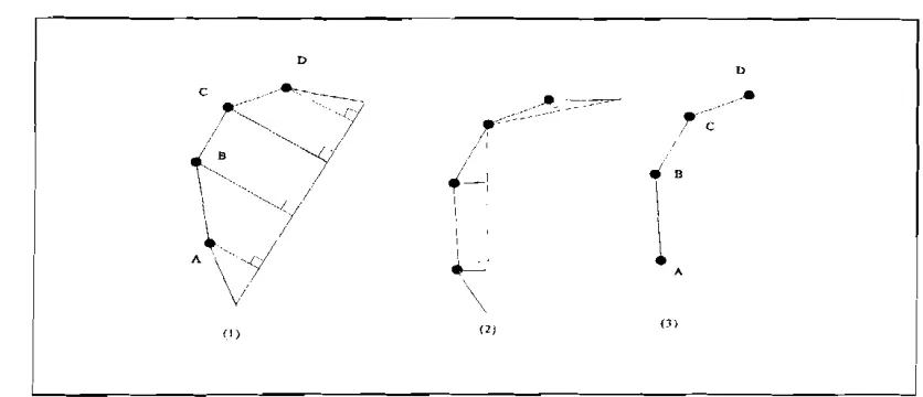
The Douglas-I'eucker algorithm is based on the following principle: the method begins by defining the first point OIl till' line as an anchor and the last point on the line as a floating point. A straight line segment is l..'st'lblished from these two points. The other points which fall in between the two are examined right .mgk ~l)th<lt straight liIlt.'. If the distance is less than the given tolerance, then the point is eliminated, other
wist.' maintained. The point which produced the longest distance to the straight line now becomes the new
D
c
..
D
..
- , --~
1
r' ::...
• B
f~·':/
(-:
\, ,--,",,(/ I
~.
I "i
A
A\/
~.
'-,..-
"_'---,--,---"-'---:----"-'
-_~
--,--I
Figure 1 The successive selection of points A, B. C, and 0 by the Douglas·Peucker algorithmPerpendicular Distance algorithm, this method employs successive triad of points. The distance between the second point and the line formed by the first and third point is calculated, If the distance is smallPr
than the preset threshold, the middle point is eliminated, otherwise, it is retnincd. This procedure continues
all along the line with every three consecutive points. This algorithm is simpler than the Douglas-Peucker
one.
The N-th. point algorithm, is based on the following principle: that is every n·th point is retained to
represent the original line. The level of gcnpralization is proportional to the size of n. This rncthod is
simpler than the second one, and easy to implement in the computer.
Angle Selection algorithm is based on th,· following principle: that is, the angle between every two
consecutive vectors of the line (i.e. three consecutive points) is compuled. If the angle is bigger than the
preset tolerance, the middle point is deleted, otherwise, the point is retain,·d,
3.0 THE COMPUTER PROGRAM
The program works as follows: After interactivC' input of filpnames and tolerances, the program reads
coordinates of points from input file and writffi out the coordinates of some of these points to the output file, The input file must be an ASCII list, where the data for each point arc in one line and the first 3
numbers are the x, y, and z coordinatcof the point separated by spaces or tab~. ThC're may be text or marC'
numbers behind the z-coordinate, but this is not use by the program, Th" output file is an ASCII list of 3 coordinates per line with the default format for r"al numbers(depend on th" compiler used), There are
two tolerances:
"line_tal" is the maximum distanc" by which the new polygon may deviate from the old
polygon. This is also used as the minimum distance between output points.
"maxdist"
is
the maximum distance between output points.veen
aller
(lUeS
:cker
two
I the
eads
Itput rsl ~
nore
st of
~are
yo-l
A Program To Generalize Contour Lines
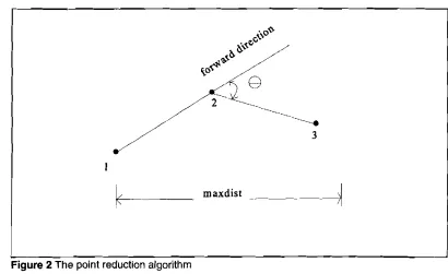
(iii) It reads points until it finds one which is more than "line_tal" away from the 'first one. This point is "point 2".
(iv) It chooses one out of 8 directions as the "forward direction" ( the direction of the vector from "point 1" to "point 2", rounded to the nearest multiple of 45 degrees).
(v) It computes the maximum and the minimum azimuth (with respect to the "forward direction") of vectors from "point 1", passing "point 2" at a distance of less than "line_tol". (Actually by simplifications in the computation the limits are slightly narrower than stated here!).
(vi) If such limits already exist, it chooses the smaller one from the old and the new maximum and the larger one from the old and the new minimum. (Narrowest limit is chosen).
(vii) It reads points until it finds one which is more than "line_tol" away from "point 2". This point is "point 3".
(viii) If the z-coordinate of "point 3" is different from the z-coordinate of "point 2", "point 2" is output, "point 3" becomes "point 1" and for the last line it outputs on the terminal the number of points read, the number of points written and the percentage of points written. Then it resumes from step (ii). (Start of a new contour line, because z is changed.)
(ix) If "point 3" is "inside", then "point 3" becomes "point 2" and the previous "point 2" is thus
forgotten. If "point 3" is not "insidett
, then "point 2" is output and becomes "point 1", "point 3"
becomes "point 2", and the program resumes from step (iv).
"point 3" is "inside" if it fulfills the following 3 conditions:
the azimuth from "point 2" to "point 3" may not deviate more than 90 degrees from the "forward direction".
the distance from "point 1" to "point 3" may not be more than "maxdist".
the azimuth from "point 1" to "point 3" is inside the limits established in steps (v) and (vi).
The program continues until the end of the input file. It then outputs the total number of point read, the total number of points written and the percentage of points written.
maxdist
~
Figure 2 The point reduction algorithm
The general idea of this program is the following: The input file is a coordinate list of the nodes of line polygons. The program copies these points to the output file omitting points such, that no one of the omitted points is(in planimetry) further than the tolerance away from the line-polygon defined by the remaining points. Many DTM conversion programs fail when contour data are too sparse, therefore points will not be omitted if the distance otherwise becomes larger than a user-defined limit.
The algorithm can be presented as in the following Pascal-like statements:
geLpoint(l);
while point_found do put_out(l); geLpoint(2); if point_found then
set_direction;
while point_found not lasLpoint do set_limits
geLpoint(3); if point_found then
if point_inside then swap(2,3)
else
put_out(2);
shift_up; ( shift to the next point)
set-direction
ne the the nts
A Program To Generalize Contour Lines
4.0 TEST AREA
The test area is around Kluang district, Johor, covers an area of approximately 20 km by 20 km (i.e. a sheet of topographic map at the scale of 1:25,(00). The relief of the area is mainly dominated by gentle sloping terrain.
5.0 TESTING PROCEDURE
The algorithm was tested using the following procedure:
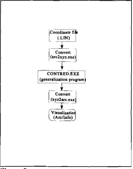
Contour data (in Arc/Info LIN format) is converted to an ASCII file of x, y, z coordinates.
The file of x, y, z coordinates is used as an input file to the program called CONTRED.EXE (Le. the generalization program), and produces the same file format for the output.
The output file then reconverted to the Arc/Info format for display and visualisation purposes.
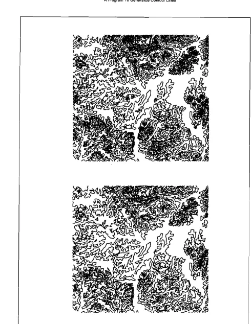
With the tolerance of 0.2 em (digitizer coordinate), 69.2% of the original data set were reduced (i.e. 5903 points were removed from the total digitized points of 8525). If we compare the two plots visually in Figure 4, then we can say that though nearly 70% of the points were eliminated, but still the overall appearence of the contours were maintained. Thus, meets one of the generalization rules.
The testing flow chart is given in Figure 4.
-Convert
r
,
(arC2Xyz.ex.e~
_-I.
CONTRED.EXE
d
r
( (generalization programC
I
Convert Il
{x.yz2an:.e~T
Figure 3
The testing flow chart.5.0 DISCUSSION
A Program To Generalize Contour Lines
•
Figure 4
Top: the original contour data set(with 8525 data points), Bottom: contours after the execution at the CONTRED.EXE program(with 2622 remained data points).References
JENKS, (1980), Thoughts on line generalisation, Proceedings of the Int. Symposium on Cartography and Computing, AUTOCARTO
IV, ACSM & ASP, pp. 209-220
McMASTER, (1987), Automated Line Generalization, CartographicQ, Vol. 24, No.2, pp. 74-111.
ZYCOR, (1984), Manual and automated feature displacement, Report of the U.S. Army Engineer Topographic Laboratories, Fort
Belvoir, Virginia, 204 p.
Acknowledgement
The author would like to thank Dipl. lng, Karl Grabmaier from Photogrammetry Division, Department of Geoinformalics, ITC, Enschpde, The Netherlands for his initial idea and invaluable discussions. The author also appreciate the review effort put by Dr. Mohammed Said Mat Lela, colleague and senior lecturer from the Department of Geoinfonnatics, Faculty of Surveying and Real Estate, Universiti Teknologi Malaysia.
-C,
by
nd
A Program To Generalize Contour Lines
Appendix A
This is the complete listing of the program to generalize contour lines. It is written in Turbo Pascal version 5.5
program ContourDataReduction(input, output);
uses crt ;
const
title array[1. 8] of string=
(' +---+' ,
'I
I',
'I
*** Program To Generalize Contour Lines ***1',
'I
I',
'I
(c)Copyright 1991 by Alias Abdul Rahman1',
'I
I',
'I
All rights reservedI',
'+---+');
type
pointer_range = 1.. 3;
pointer_arraLoCreal = array[pointer_range] of real;
pointer_array_oCpointer = array[pointer_range] of pointer_range;
var
direction : integer;
incount, outcount,
in_total, out_total : integer; dx, dy, limit1, Iimi12 : real; line_tol, maxdist : real; limit, last_pt, point_found : boolean;
x, y, z : pointer_arraLoCreal;
pointer : pointer_arraLoCpointer; infile, outfile : text;
infilename, outfilename : string;
procedure pause;
begin writeln;
write('Press <ENTER> to continue'); readln;
end; { pause}
procedure copyright; var i: integer; begin clrscr; gotoXY(1,10); for i := 1 to 8 do writeln(Title[i]:62); pause;
clrscr:
end; { copyright}
procedure openlnputFile( var Infilename : string);
begin
write('Enter input filename >'); readln(lnfilename);
assign(infile, 'nfilename); reset(infile);
end;{ openlnputFile }
procedure openOutputFile( var outFilename : string);
begin
write('Enter output filename >'); readln(outFilename);
assign(outfile,outFilename); rewrite(outfile);
end; ( openOutputFile )
function forwad( from, towards: integer) : boolean;
begin
dx := x[pointer[towardsll- x[pointer[fromll; dy := y[pointer[towardsll- y[pointer[fromll; case direction of
1 : forwad := dx > 0; 2 : forwad := dx > -dy; 3 : forwad := dy > 0; 4 : forwad := dx < dy; 5 : forwad := dx < 0; 6 : forwad := dx < -dy; 7 : forwad := dy < 0; 8 : forwad := dx > dy; end;
end; { forwad }
procedure prepare;
var
maxlength, i : integer;
begin
for i := 1 to 3 do pointer[i) := i;
openinputFile(infilename);
write('Enter the tolerance for omitting points :'); readln(line_tol);
writeln;
write('Enter the maximum distance between output points :'); readln(maxdist);
writeln;
openOutputFile(outfilename); incount := 0;
•
A Program To Generalize Contour Lines
procedure shift_up;
var
free : integer;
begin
free := pointer[1]; pointer[1] := pointer[2j; pointer[2] := pointer[3]; pointer[3] := free; end; { shift_up}
procedure swap( pt1, p12 : integer); var
help : integer;
begin
help := pointer[pt1]; pointer[pt1] := pointer[p12j; pointer[p12] := help; end; {swap}
procedure put_out( pt: integer); begin
writeln(oulfile, x[pointer[pt]J: 10:3, y[pointer[pt]]: 10:3, z[pointer(pt]J: 10:3); outcount := succ(outcount);
end; { put_ou1}
function distance( from, onto: integer) : real; begin
dx := x[pointer[onto]]- x[pointer[from]]; dy := y[pointer[onto]]- y[pointer[from]]; distance := sqrt(dx*dx + dy*dy); end; { distance}
procedure get_point (pt : integer); var
this_point: integer;
procedure read_point;
begin
point_found := not eof(infile); if point_found then
begin
readln(infile, x[this_pointj, y[thisJlointJ, z[this_point]}; incount :'" succ(incount);
end;
end; { read_point}
begin { get_point} this_point := pointer[pt]; if (pt = 1) then
read_point else
repeat
read_point;
until (distance(pt, pt-1) > line_tol) or not point_found; end; { geLpoint }
procedure set_direction;
const
tan_pi_8 = 0.41421;
var
dylim, dxlim : real;
begin { set_direction}
dx:= x[pointer[2]]- x[pointer[1]]; dy := y[pointer[2]]- y[pointer{1]]; dylim := tan_pL8 • dx;
dxlim := tan_pL8 • dy; if (dy > -dylim) then
if (dx > dxlim) then if (dy < dylim) then
direction := 1 else
direction := 2 else
if (dx > -dxlim) then direction := 3 else
direction := 4 else
if (dx < dxlim) then if (dy > dylim) then
direction := 5 else
direction := 6 else
if (dx < -dxlim) then direction := 7 else
direction := 8; limit := false;
A Program To GeneraLze Contour Lines
function tangent: real;
begin
case direction of 1, 5 : tangent := dyldx;
2,6: tangent := (dy-dx)/(dx+dx);
3, 7 : tangent := dxldy;
4, 8: tangent := (dx+dy)/(dy-dx);
end;
end; { tangent}
{ tangent of the angle with the "forward direction" }
procedure set_limits;
var
lim1, Iim2, k1, k2, kk: real;
begin
k1 := tangent;
k2 := line_toll distance(1, 2); kk := k1 • k2;
lim1 := (k1 +k2) I (1.0-kk);
lim2:= (k1-k2) I (1.0+kk); if limit then
begin
if Iim1 < limit1 then limit1 := Iim1; if lim2 > limit2 then
limit2 := Iim2; end
else begin
limit1 := Iim1; limit2 := lim2; limit := true; end;
end; { seUimits }
function inside: boolean;
var
ok :
boolean;
k1 : real;begin
last_pt := (z[pointer[3]] <> z[pointer[2]]); if last_pt then
inside := false else
begin
ok := forwad(2, 3) and (distance(1, 3) < maxdist); if ok then
begin
k1 := tangent;
ok := (k1 < limit1) and (k1 > limi12);
end; inside := ok; end;
end; { inside}
{ inside, next point has the same Z value as the previous one and is inside the permitted area, which is :
- forward from point 2 - not too far from point 1
- inside the limilling rays defined by Iimit1 and Iimi12 }
procedure end line;
begin
put_out(2);
writeln(outcounl:4, ' from " incounl:4, '
C,
outcount '100.0 I incounl:3:1, '%)');in_total := in_total + incount; out_total :=
ouUotal
+ outcount; outcount := 0;•
A Program To Generalize Contour Lines
begin { main program}
copyright; prepare; get_point(1);
while point_found do begin
put_out(1); get_point(2); if poinUound then
begin
set_direction;
while poinUound and not last_pt do begin
seUimits; get_point(3); if poinUound then
begin
if inside then swap(2,3) else
if not last_pt then begin
put_out(2); shift_up; set_direetion; end;
end; end; end; endline; end;
writeln(' in total: ',ouUotal:4, ' from " in_total:4, '(', out_total * 100.0 I in_total:3:1, ''IoJ'); writeln;
writeln('Press <ENTER> to continue'); readln;
c1ose(infile); c1ose( outfile);
end. { main program}