University of Windsor University of Windsor
Scholarship at UWindsor
Scholarship at UWindsor
Electronic Theses and Dissertations Theses, Dissertations, and Major Papers
9-14-2018
Optimal Route Planning with Mobile Nodes in Wireless Sensor
Optimal Route Planning with Mobile Nodes in Wireless Sensor
Networks
Networks
Chris Zygowski University of Windsor
Follow this and additional works at: https://scholar.uwindsor.ca/etd
Recommended Citation Recommended Citation
Zygowski, Chris, "Optimal Route Planning with Mobile Nodes in Wireless Sensor Networks" (2018). Electronic Theses and Dissertations. 7594.
https://scholar.uwindsor.ca/etd/7594
This online database contains the full-text of PhD dissertations and Masters’ theses of University of Windsor students from 1954 forward. These documents are made available for personal study and research purposes only, in accordance with the Canadian Copyright Act and the Creative Commons license—CC BY-NC-ND (Attribution, Non-Commercial, No Derivative Works). Under this license, works must always be attributed to the copyright holder (original author), cannot be used for any commercial purposes, and may not be altered. Any other use would require the permission of the copyright holder. Students may inquire about withdrawing their dissertation and/or thesis from this database. For additional inquiries, please contact the repository administrator via email
Optimal Route Planning with Mobile Nodes in Wireless Sensor Networks
By
Christopher Zygowski
A Thesis
Submitted to the Faculty of Graduate Studies
Through the School of Computer Science
In Partial Fulfillment of the Requirements for
The Degree of Master of Science
At the University of Windsor
Windsor, Ontario, Canada
2018
Optimal Route Planning with Mobile Nodes in Wireless Sensor Networks
By
Christopher Zygowski
APPROVED BY:
F. Baki
Odette School of Business
S. Goodwin
School of Computer Science
A. Jaekel, Advisor
School of Computer Science
DECLARATION OF ORIGINALITY
I hereby certify that I am the sole author of this thesis and that no part of this thesis has
been published or submitted for publication.
I certify that, to the best of my knowledge, my thesis does not infringe upon anyone’s
copyright nor violate any proprietary rights and that any ideas, techniques, quotations, or any
other material from the work of other people included in my thesis, published or otherwise, are
fully acknowledged in accordance with the standard referencing practices. Furthermore, to the
extent that I have included copyrighted material that surpasses the bounds of fair dealing within
the meaning of the Canada Copyright Act, I certify that I have obtained a written permission
from the copyright owner(s) to include such material(s) in my thesis and have included copies of
such copyright clearances to my appendix.
I declare that this is a true copy of my thesis, including any final revisions, as approved
by my thesis committee and the Graduate Studies office, and that this thesis has not been
ABSTRACT
Wireless Sensor Networks (WSN) are a collection of sensor nodes that sense their
surroundings and relay their proximal information for further analysis. They utilize wireless
communication technology to allow monitoring areas remotely. A major problem with WSNs is
that the sensor nodes have a set sensing radius, which may not cover the entire field space. This
issue would lead to an unreliable WSN that sometimes would not discover or report about events
taking place in the field space. Researchers have focused on developing techniques for
improving area coverage. These include allowing mobile sensor nodes to dynamically move
towards coverage holes through the use of a path planning approach to solve issues such as
maximizing area coverage. An approach is proposed in this thesis to maximize the area of
network coverage by the WSN through a Mixed Integer Linear Programming (MILP)
formulation which utilizes both static and mobile nodes. The mobile nodes are capable of
travelling across the area of interest, to cover empty ‘holes’ (i.e. regions not covered by any of
the static nodes) in a WSN. The goal is to find successive positions of the mobile node through
the network, in order to maximize the network area coverage, or achieve a specified level of
coverage while minimizing the number of iterations taken. Simulations of the formulation on
DEDICATION
I dedicate this thesis to my parents Krystyna Zygowska and Arkadiusz Zygowski, for
their motivation and blessings without which I would not have made it this far . To my siblings
ACKNOWLEDGEMENTS
First I would like to express my gratitude to my supervisor Dr. Arunita Jaekel for her
motivation and guidance. Thank you for spending your time to support me during my graduate
degree. Your knowledge and patience have been invaluable and for that I cannot thank you
enough.
I would also like to thank my remaining committee members Dr. Scott Goodwin and Dr.
Fazle Baki for their help and support.
I would like to thank my family and friends for sticking with me and supporting me.
Finally I would like to thank the Computer Science department faculty and staff,
Contents
DECLARATION OF ORIGINALITY ... iii
ABSTRACT ... iv
DEDICATION ...v
ACKNOWLEDGEMENTS... vi
LIST OF TABLES ... ix
LIST OF FIGURES ... ix
ABBREVIATIONS ... ix
CHAPTER 1 ...1
1.1 Introduction of Wireless Sensor Networks ...1
1.2 Thesis Overview ...2
1.3 Methods and Software ...2
1.4 Motivation ...3
1.5 Problem Statement ...4
1.6 Solution Outline ...5
1.7 Thesis Organization ...7
CHAPTER 2 ...8
2.1 Overview of Broad Research ...8
2.2 Basic Terminology...9
2.3 Fundamental concepts ... 12
2.4 Current Research Issues in WSNs ... 18
2.5 Literature Review of Related Work ... 22
CHAPTER 3 ... 37
3.1 Outline of our proposed approach ... 37
3.1.1 Novel and Innovative Features ... 39
3.2.1 Contribution ... 40
3.2.2 Importance of Area Coverage ... 40
3.2.3 Importance of Mobile Nodes ... 42
3.2.4 Types of Mobility ... 43
3.2.5 Assumptions ... 44
3.2.6 Physical and Network Model ... 45
3.3 MILP Formulation Approach ... 48
3.3.1 MILP - Coverage ... 49
3.3.2 MILP - Time Interval ... 50
CHAPTER 4 ... 53
4.1 Simulation Setup... 53
4.2 Formulation Performance... 56
4.2.1 Limitations of Results... 57
4.2.2 Comparison with Existing Approaches ... 59
4.2.3 Results with Varying Parameters ... 65
4.2.4 Results with Comparison of MILP-C to Heuristic Methods ... 69
CHAPTER 5 ... 75
BIBLIOGRAPHY ... 77
LIST OF TABLES
Table 1. Comparison with Proxy-Based Bidding Protocol ... 62
Table 2. 15x15 Grid Comparison of Iterations used in Planned Route ... 66
Table 3. 15x15 Grid Comparison of Run Time used by MILP formulations ... 67
Table 4. 20x20 Grid Comparison of Iterations used in Planned Route ... 68
Table 5. 20x20 Grid Comparison of Run Time used by MILP formulations ... 69
Table 6. 15x15 Percentage of Uncovered Grid Area Covered by Heuristic ... 71
Table 7. 20x20 Percentage of Uncovered Grid Area Covered by Heuristic ... 72
LIST OF FIGURES
Figure 1. Example of Messages Relayed through Multi-hop Routing ... 10Figure 2. Classification of Coverage Categories ... 13
Figure 3. Standard Deterministic Path Planning Approaches [32] ... 17
Figure 4. WSN Architecture Components ... 37
Figure 5. Progression of Movement of Mobile Node over 15 Iterations ... 38
Figure 6. Sample Sensing and Communication Range of a Sensor Node ... 44
Figure 7. Example of Field Grid Map ... 47
Figure 8. Sensing Capabiliity of a Sensor Node ... 47
Figure 9. High Level Process of our Approach ... 53
Figure 10. Example Constraint Deconstruction ... 55
Figure 11. Comparison of proposed approaches with Dynamic Path Planning Algorithm ... 60
Figure 12. Comparison with CMN ... 64
Figure 13. Pseudocode for Greedy Heuristic... 70
Figure 14. Pseudocode for Random Heuristic ... 71
Figure 15. 80x100 Grid Iteration Comparison of MILP-C against Heuristic Methods ... 73
ABBREVIATIONS
CHAPTER 1
Introduction
1.1 Introduction of Wireless Sensor Networks
Wireless Sensor Networks (WSNs) are networks composed of a set of sensor nodes
communicating amongst themselves and a data collection center [1]. One of the main functions
of WSNs is to supervise particular changes in an environment and report any results for further
analysis [1]. The wireless sensor nodes, which compose WSNs, collaborate to jointly perform
sensing tasks on a larger scale. Recent advancements in microprocessors, electro-mechanics and
wireless communication allow for the design of smaller and lower cost sensor nodes. This, in
turn, leads to an easier access to the construction of large WSNs [2].
In this thesis, the sensor nodes of WSNs are assumed to be small battery-powered
autonomous devices able to collect information regarding their immediate vicinity through
attached sensors [3][4]. The information acquired is processed locally and then communicated to
a data collection center, also known as a base station or sink. Specifically, the sensor nodes are
typically equipped with a sensing unit for data acquisition, a basic processing unit with limited
computational power and a wireless communication unit onboard. Each of these components
have limited capabilities including memory for data collection, energy for operation and
1.2 Thesis Overview
WSNs are widely used for monitoring large areas for conditional changes. In many
scenarios, sensor nodes are used as stationary sentries after their initial deployment. This initial
network configuration can be used to compute the current network coverage. However, this
approach may lead to overlapping redundant node coverage depending on the initial condition of
the static nodes. Following this step will be the deployment of mobile sensor nodes, which will
have the capabilities of movement to the areas which are not yet covered by static sensor nodes.
However, equipping every node with movement capabilities increases the network cost and may
lead to collisions. Thus a limited amount of mobile nodes are utilized to keep a balance between
overall coverage and sensor node cost.
1.3 Methods and Software
In order to accomplish the task of optimizing the total area covered by all sensor nodes,
the setup of the WSN is first determined. A set of non-relocatable static sensor nodes will be
randomly deployed in the given area. Accompanying these static nodes will be a small subset of
mobile sensor nodes which will be able to modify their position while being subject to mobility
constraints. Using their controlled mobility, these mobile nodes will provide coverage to areas
which are not in the sensing radius of the static nodes [1]. The goal reached is to utilize and
exploit the manoeuvrability of these mobile nodes in order to optimize the total sensing coverage
possible in the least number of time steps, given the infrastructure.
There have been various algorithms proposed which determine mobile sensor nodes
movements such that they move to uncovered areas in order to attain a more balanced coverage.
The main difference between these approaches lies in how the algorithms compute the positions
node path finding, is no different to previous approaches, however, the method used to
accomplish the task is original. Static sensor nodes are first placed in the desired area while a
Mixed Integer Linear Programming (MILP) Formulation is utilized to determine the optimal path
the mobile node should take to achieve an optimal area coverage.
1.4 Motivation
Utilizing mobile nodes to cover areas, which are uncovered in the desired search space,
will reduce the possibility of data being missed in areas that were not yet covered. In many
scenarios, static sensor nodes may not be distributed into a desired location [6][7]. The target
field may be a hostile environment with uncontrollable factors such as obstacles or wind which
will affect the initial deployment in the target area. Finding an optimal path that these mobile
nodes will take to optimize area coverage is also very important to various application fields.
The addition of mobile nodes aids many different application fields such as civil
application like health care, security, environmental monitoring and also military applications
[2][8]. These fields can be categorized into resource management (such as in data centers),
remote monitoring, target tracking and event detection. For applications in health care, wireless
sensor networks can provide less invasive patient monitoring and health care possible. These
networks are also helpful for security systems which includes intrusion detection through
patrolling alarms, military surveillance and can be attached to people or vehicles to protect them
from unnecessary circumstances. Finally, WSNs are also very helpful for environmental
monitoring including the sensing of unnatural conditions such as pollution in the air, water or
soil of a given area. The addition of dynamically patrolling sensor nodes [3] to static node WSNs
1.5 Problem Statement
Research on WSNs has evolved over time. Initially, the strategy for deployment of sensor
nodes was to simply place more and more until the problem requirements were reached [9]. This
initial process is inefficient since the addition of an increasing number of nodes leads to a
prohibitive cost, not only monetary but also in other factors such as steeper deployment,
management and maintenance costs [10]. Lastly, adding more nodes may lead to a number of
redundant nodes which may overlap in their sensing radius'. Mobile nodes are utilized in order to
circumvent these problems and other similar issues.
This thesis experiments on the use of mobile nodes in the context of WSNs to solve
problems dealing with area coverage. These problems include allowing the WSN to handle
instances where there may be random failures of nodes while keeping energy efficiency and
coverage efficiency in mind [11]. These problems are all with regards to keeping as good a
coverage of the target area as possible for as long as possible. Random failure of a given set of
the nodes can lead to coverage holes [11][12], which in turn will need to be covered by mobile
nodes. On the other hand, sensor nodes have a limited battery power, thus energy usage of the
mobile nodes must be taken into account when planning mobile node paths. The path planning is
conducted in such a way that the route taken by mobile nodes is covering the maximal number of
coverage holes in the least amount of time.
The main problem being addressed is of increasing area coverage by exploiting mobility
of mobile nodes in WSNs. Coverage of the given area is a significant issue when deciding on the
deployment and performance of the WSN. The surveillance quality or total coverage monitored
by the sensor nodes signifies how well the region is monitored and how effectively the WSN
reduction of blind zones, or coverage holes, and redundant coverage of overlapping sensing
radius' of sensor nodes. This thesis specifically maximizes an optimal area coverage of the search
space in the least number of iterations. Event detection is a large component of the applications
using WSNs which relies heavily on area coverage. In event detection, sensors must be able to
reliable detect an event in the given search space. Thus, an optimal area coverage by the mobile
nodes is necessary to assure accurate detection of transpiring events [6][7].
A large factor of this thesis is understanding the various network parameters necessary to
improve the coverage of wireless sensor nodes depending on varying scenarios. Specifically, this
thesis addresses the following questions:
1. What is a sufficient condition for an optimal area coverage using a WSN?
2. How can we design an MILP formulation for sparse and highly dense deployed WSNs in
order to guarantee maximum area coverage with a minimum number of mobile node
movements?
1.6 Solution Outline
In order to overcome the above-mentioned problems, there have been many previous
attempts to alleviate them including increasing the number of static nodes [7] or adding sensor
nodes which have a larger sensing radius [11]. Both of these approaches have the problem of
increasing cost by adding these nodes to the infrastructure. To circumvent these issues, this thesis
proposes using mobile sensor nodes in an optimally found path. The combination of static and
mobile sensor nodes in tandem is termed a mixed WSN [1][11][13]. In the literature, mobile
nodes are moved either by a dynamic path planning approach or in a deterministic fashion with a
nodes are routed through the search space grid using a MILP formulation to determine the
optimal path the mobile node should take to achieve complete grid area coverage.
This thesis, uses mobile nodes in a deterministic fashion, in which the optimal movement
path of the mobile nodes is determined based on the initial random deployment. A dynamic or
random movement pattern for mobile nodes is not handled in this thesis. The mobile nodes are
mainly treated as nodes used to 'heal' uncovered areas which are not yet covered by static nodes.
They may also have to collaborate with the static nodes, since some static nodes may fail. Thus
the mobile node must take these situations into account when determining an optimal path to
maximize coverage.
Mobile nodes are sensor nodes mounted on a mobile robot. They will be used to increase
the area of coverage which will lead to a lesser probability that an event or change in the
environment is missed and hopefully minimize the time taken to report an event. Furthermore,
the introduction of mobility will allow for the WSN to react better to inaccurate initial node
deployment and possible node failure. Since the number of mobile nodes is usually a small
fraction of the total amount of sensor nodes, the added cost is very minute. Not only do mobile
nodes aid in fault tolerance, reliability and increasing overall coverage, but they also reduce the
cost compared to a dense deployment of sensor nodes or the extra cost of forcing the initial
deployment into an optimal condition.
Specifically, this thesis introduces MILP formulations which guide mobile nodes along
an optimal path, such that the maximum coverage of uncovered areas is achieved in the least
1.7 Thesis Organization
The remainder of the thesis is structured as follows. Chapter 2 reviews literature work
related to maximizing area coverage using sensor networks. This section will also act as an
overview of the terminology used with WSNs and important concepts such as the assumptions
specified. Chapter 3 highlights the contributions of this thesis. This includes the proposed
approach used, the network model used and a comparison of area coverage and mobile node time
step usage against existing approaches. Chapter 4 outlines simulation results. This section will go
over the simulation setup, a comparison of results and give a general grading on how well the
algorithm performed. Chapter 5 will conclude the thesis with a summary of the main topics of
CHAPTER 2
Literature in the Research Area
2.1 Overview of Broad Research
This thesis' presented work is related with two main research fields. They include
maximizing area coverage in WSNs and path planning [11][15][16]. Wireless Sensor Networks
(WSNs) are networks consisting of nodes communicating amongst themselves. Research topics
using WSNs usually consist of supervising and reporting on particular environmental changes. In
order to circumvent problems regarding coverage holes [2][6][9][17], connectivity
[3][11][18][19], and energy efficiency [20][21][22] mobility was added as a research area for
WSNs. The introduction of mobile nodes in WSN [23][24] not only added a new outlet for
innovation, but also necessitated the development of suitable path planning approaches, for the
mobile nodes. Path planning has been investigated from multiple angles when dealing with
sensor node mobility. Whether the path planning method is being used to cover uncovered areas
or simply to move around obstacles, they all have their advantages and resultant downsides
[15][16].
From the first general solutions of using WSNs, which included simply adding more
sensor nodes to the search space or formulating smart deployment strategies; the novelty of
mobility as an addition to WSNs has shown much promise [3][23]. Whether dealing with
uncontrollable aspects of the environment or adding new functions to an older idea,
detection and remote monitoring. Research on mobility in WSNs can be found in all aspects of
daily life. From health care to environmental monitoring to military operations, mobile WSNs
have been used to solve or improve existing solutions for many facets of each of these fields.
2.2 Basic Terminology
Some terms which will be used on multiple occasions during this thesis are:
Wireless Sensor Network (WSN) : These networks use wirelessly communicating nodes to relay
information between each other. The nodes have sensors attached to them which allow for
reading and logging information regarding its adjacent environment. The use of mobile nodes in
WSNs is studied in this thesis [1][5][7][11].
Area Coverage : is the ratio of area which is within the sensing radius of sensor nodes in a WSN
versus the total area of the search space. Total area coverage means that every cell within the
monitoring field is covered by at least one sensor node's sensing radius [4][6].
Network Topology : is an outline denoting the communication connections between the nodes of a
WSN. In general, the topology shows which nodes can relay information to other components of
the network [4][12].
Sensor Node : Stationary nodes are the backbone of WSNs. They are the devices with capabilities
to wirelessly communicate to other node devices in the network. These devices are also equipped
with sensors. The sensors installed have a wide variety of uses such as measuring temperature
changes, pollution levels, detecting movement changes and for basically any application field in
need of event detection or remote monitoring. Recently, sensor nodes have also been equipped
Data Center : is the processing center of the WSN. It houses the information gathered from the
search space and analyzes it so that the useful information is used to solve real world problems.
Base station and sink are both terms used to describe a data center [1][25].
Data Collector Node : is an intermediate node between the data center and the sensor nodes. It is
mainly used to collect information from sensor nodes and then will relay it to the data center
[1][26].
Communication Radius : is the distance around a node at which it can send and receive messages.
If the distance between two nodes exceeds the communication range, they will not detect one
another and will not be able to relay message between themselves [1][7].
Sensing Radius : is the distance around a node that it is able to sense changes in its environment.
Similarly to communication radius, the node cannot sense or report fluctuations outside of its
sensing radius [1][7].
Multi-hop routing : is the way in which sensor nodes can pass their gathered information along
other sensor nodes to reach the data center as displayed in Figure 1. Specific nodes are
sometimes added in WSNs as a possible collector of the data which is passed through multi-hop
routing. This routing is mainly used when the sensor nodes are not in communication range of
Euclidean distance: is a measurement of distance. For reference, this distance is between two
points (x1, y1) and (x2, y2) in a two dimensional plane given by the formula
[7][14].
Centroid : is the average taken for all the positions of all the points or nodes. All the coordinate
directions are taken into account when determining this "center" point in relation to all the nodes
[26].
Cluster : is a grouping of objects. This group will usually have a cluster-head which is the authority
object that determines how and what information is passed between the objects in the cluster.
Clusters are usually formed based on proximity. This means that objects that are closer to one
another will usually form a cluster and those that are far apart will be usually part of different
clusters [4].
Mixed Integer Linear Programming (MILP) : is a mathematical optimization program using
integer and binary variables to formulate a sequence of equations. These equations will be used
in tandem to create something called a formulation. This formulation must have an objective
function, which the MILP will either try to maximize or minimize towards. It will also contain
constraint equations which will limit the upper and lower values of the variables. The constraints
must limit the objective function as well, so that an objective value can be reached [27].
CPLEX: is an optimization software. Specifically it is a mathematical programming solver for
linear, quadratic and mixed integer programming. Linear and Quadratic programming both share
similar traits to MILPs, however they allow linear and quadratic equations respectively [25].
Bidding protocols : are method in which one decision maker will make a decision based on the
aggregated information from other decision makers. One node will act as a decision maker and
which interests the decision node and ask for the other nodes' input. The decision node will wait
an allotted time to wait for all the other nodes to send back their known information on the
subject. Each other node will send this as a "bid." Once the time is up, the decision node will
stop the auction and will choose between the information it has gathered to determine a suitable
decision to make [1][10].
Voronoi Diagram : are structures which represent proximity information for a set of points or
nodes. The method used is to partition the search space into cells such that the area in a cell
surrounding a sensor node is closest to that node and no other. Thus the segmented area is
basically the search space broken up into sections which surround each sensor node [10][28].
Path Planning : is an approach which determines the path a node moves along in the given area of
interest. Varying factors in the space surrounding a node can persuade the node to move in a
certain direction. The way in which the path is determined may be pre-determined or
dynamically changed [2][9][11].
2.3 Fundamental concepts
WSNs are a deployment of sensor nodes in a specific region or area. The sensor nodes
are specifically designed to capture some type of environmental change. These network nodes
are distributed such that events will be tracked or detected with the highest accuracy. The sensor
nodes are able to communicate this information to any of the components of a WSN. These
components include other sensor nodes for multi-hop routing, a data collector node for quicker
relay of data to the data center or to the data center directly for further data processing.
There are three main topologies which are Star, Tree and Mesh. The Star topology
denotes a network where each node connects to the data sink directly. This method allows for
connected in a hierarchical structure. The root or top of the hierarchy is the data center, which
allows the connected nodes to feed forward information through other nodes in the hierarchy
towards the sink. The Mesh topology constructs a network where each node can connect to
several other nodes including the sink. This method allows for greater node interaction for
dynamic approaches.
The ways which the components of a network communicate amongst one another may
vary depending on the application. For many applications, there are one of two main problems
which are solved. These are elongating the lifetime of the network through energy efficiency and
increasing area coverage of the WSN. In order to decrease energy usage many approaches try to
spread the usage of the components of the WSN so that one component is not excessively used
and draining its energy. This is mainly for applications which have constant communication
among sensor nodes.
This thesis mainly focuses on the improvement of area coverage and the reduction of
coverage holes through mobility of sensor nodes. When speaking of research on coverage
improvements through mobile nodes in WSNs, the different categories of area coverage must be
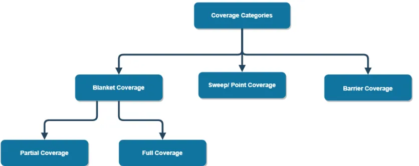
defined. The various types of coverage are "blanket coverage, barrier coverage, sweep coverage
and partial coverage" [29][30] and are displayed in Figure 2.
Blanket coverage is the term used to describe the requirement that the entire search space
is monitored. Degree of coverage is a variable used to represent the ability of the WSN to cover
the search space. It is the ratio of the space which is covered by sensor node's sensing radius'
against the total space of the monitoring area. A degree of coverage of one symbolizes that the
whole area is monitored by at least one sensor node. The higher the degree is, the more area is
covered by sensor nodes. This means that some subspaces will also have overlapping sensing
radius coverage, which may be necessary for some types of applications. A high degree of
coverage may be essential to an application which monitors vital facilities with disastrous
downsides to fluctuations. While different applications will require different degrees of
coverage, a degree of coverage of at least one is usually the bare minimum. This type of
coverage is useful for hostile environments where the monitoring of the environment is crucial.
This could be helpful for applications such as monitoring volcano activity where the
consequences of a missed event could lead to fatal consequences. Another specific example of
this type of coverage could be habitat monitoring of wild animals which would allow for
constant supervision of the wildlife [29][31].
Barrier coverage deals with a perimeter or boundary coverage where the WSN is
deployed on the border of a given application space. Thus the whole area is not needed to be
covered, since entry and exit from the area of interest is monitored. The sensor nodes of the
WSN are usually desired to overlap their sensing radius with adjacent nodes' sensing radius'.
This is so that any condition such as movement which may occur in the surveillance node area
will be sensed with a higher chance of less false alarms or missed events. The main usage of this
illegal unwanted agents in a warehouse or facility and detecting the amount of traffic driving
through a certain road [29].
Sweep coverage refers to applications with certain "points of interest" (POI) which have
significant strategic value and must be monitored thoroughly. These coverage problems must
guarantee that these POIs are covered during a certain time frame so that the important
information needed is relayed without fail. This type of coverage is used for application such as
one using weather buoys which are introduced in bodies of water to collect environmental data
of their surroundings. Other applications of sweep coverage can include detection of the spread
of forest fires, military patrol operations and monitoring along sections of pipelines for any faults
along the pipes [29].
Partial coverage is essentially a subsection of blanket coverage. The difference between
the two is that instead of striving for a degree of coverage, partial coverage only desires that
resultant coverage is greater than a particular predetermined value. This type of coverage is
mainly used for applications which need a general sampling of the search space rather than a
rigorous accounting for the entire space [29].
These categories of coverage are present in any real world application. The way in which
an algorithm uses environment information to setup a WSN will determine its performance when
attempting to optimize one of these types of coverage. Beyond the initial setup of the WSN is the
setup of an algorithm for fault tolerance and to handle irregularities in the search space grid.
A general approach to circumvent issues after initial deployment of a WSN is to use a
path planning technique. As noted above, this is the way a route is set in place for the mobile
node to take during the next set of time steps. Different factors such as energy consumption, area
technique is created. An important aspect of path planning to understand is the various dynamic
and deterministic approaches that can be used. Below are different techniques and path planning
approaches that are found in the literature.
Grid Scan Algorithm: will sample each cell in the search space one by one. During this runtime, a
particular trait will be investigated and set as a variable to be used later. This algorithm is used in
other area coverage approaches. An example usage would be for helping mobile nodes determine
whether each cell has been covered by a static node's sensing radius. Cells which are uncovered
will be set to a base value for future reference in a variable. Those uncovered nodes which are
surrounded by other nodes, which are uncovered, will increase their value according to how
many nodes they are surrounded by and those nodes' values. These final values will indicate how
large the coverage holes are depending on which cell is queried. The mobile nodes will each run
this algorithm to find the closest coverage hole in their vicinity [2][9].
One scan algorithm : is a heuristic used to improve the performance of the Grid Scan algorithm.
This algorithm will disregard mobile nodes until the final step of the process. While the Grid
Scan approach will run for each mobile node, the One Scan approach will simply run over each
cell and store their values. The coverage holes which are found will still be ranked by their size.
At the last step, the mobile nodes will check their immediate surroundings for information
regarding coverage holes. They will also update the value of the cells which they will be
covering [2].
Zoom algorithm : is a divide and conquer approach. First the grid is split into four parts and each
part is checked for their total amount of uncovered nodes. The sector with the most uncovered
cells. This area will be labelled with a variable as the largest coverage hole. The algorithm will
then be used again until all coverage holes are ranked from largest to smallest [1][2][9][11].
Game theory : is an approach where a model is created to study the cooperation and conflict
between decision makers. The decision makers are ultimately tasked with optimizing a criteria
for their own benefit. The interactions between the decision makers and their attempts to
optimize their criteria shows emergent properties as to their optimal strategies to beat their
opponent [6].
"Standard" Deterministic Path Planning : uses a schema at the first time step to pre-determine
where the mobile node should move to at any given future time step. This schema is simply to
move the mobile node far enough that it will cover as much new cells as possible, while also not
leaving coverage holes in the places it has passed. These types of approaches do not take into
account other static node coverage and do not use logic to determine the route. They will simply
move in a certain direction until an area boundary is met and then will turn towards a
perpendicular direction and continue movement [11].
Figure 3. Standard Deterministic Path Planning Approaches [32]
Receding horizon algorithm : is a particular path planning approach allows a node to estimate a
set of future positions it may move to at each time step. The set of positions which the node may
which position to move to based on various parameters such as coverage or energy usage
[2][9][11].
Potential Fields : is a concept where each node is imagined to have an invisible field around itself.
The node will be repelled when it is near obstacles or other nodes which are within this field. A
"friction force" is added as well which will slow the node drastically after it begins to move. The
node will still be able to move away from other objects within its potential field, but will quickly
come to a halt after the object moves out of reach of the nodes field [14].
2.4 Current Research Issues in WSNs
In regards to WSNs, there have been many advancements and approaches proposed, in
order to circumvent issues such as coverage capability and energy efficiency. Recent use of
mobility of nodes in WSN has led to the creation of some innovative techniques to solve a
variety of issues.
A recent category of work being done on WSNs is regarding data collection and transfer
between the components of the network. These strategies aim to generally increase the lifetime
of the network's nodes by spreading the load of node usage equally across all the network
components. Furthermore, they aspire to assist the network in relaying information in an optimal
manner. This is done so that information will be transferred within a timely manner and the data
is not lost before reaching the data center.
Some recent papers on data gathering and transport in WSN are discussed in this section.
[33] outlines algorithms detailing the use of mobile sinks to collect sensor node data so as to
prolong the lifetime of the node network. The main objective is to collect data at regular intervals
from mobile nodes using a minimum amount of mobile sink. It also outlines a major drawback of
sensor nodes. This is a disadvantage since it may lead to significant data collecting delay from
sensors that are at the end of the route which the mobile sensors are moving along. Information
gathering must be done in a timely fashion since sensor nodes have a limited amount of memory.
It their memory becomes full and they have no outlet to relay the information, then this causes a
buffer overflow where new information or old information is disregarded.
Two approximation algorithms are generated to reach close to optimal results in a
reasonable amount of time. These methods propose that mobile sinks visit positions of mobile
nodes to collect their data. These algorithms are generalized so that the mobile sinks need only
move within communication range of the mobile nodes to gather their data. The simulations
conducted show an improvement over other algorithms which do not account for the
communication boundary when determining the path planned for each mobile sink.
[26] deals with large scale WSNs that stretch across large geographic areas. These
networks contain upwards of a thousand sensor nodes, which all need to be factored into an
efficient data collection scheme. Approaches using mobile sinks and data collectors are both
studied.
The first method uses mobile data collectors called MULE. This method will first
partition the nodes of the network into clusters. The centroids of each cluster will house one
mobile collector. The collector will utilize multi-hop routing. All the nodes in the cluster will
relay their information from node to node until it reaches the mobile collector. Then collector
will finally carry the data to a data sink and then return to its cluster. The second approach uses
mobile data sinks which are categorized as aerial vehicles. The mobile sinks will path between
the initiation of data gathering. All the nodes of the cluster will receive the request and will
directly us a single-hop approach to directly respond to the sink.
Both techniques were shown to have their advantages and disadvantages. The drawbacks
which were highlighted when using mobile data collectors is that there may be a data "flooding"
problem. This arises when the nodes that are closest to the collector must process the relay of
information from nodes on the outer edge of the cluster. This leads to an increase energy usage
for these nodes which leads to quicker energy consumption and node failure. The second
method also had a similar drawback, since in order for each node in the cluster to communicate
with the mobile sink they must all use long range communication transmission. This is more
taxing than short range transmissions, thus each node will slowly use more energy over time
compared to using mobile collectors.
A common issue detailed in papers regarding WSNs and observed in the previous paper
is energy consumption in WSNs. Recent work has also shown possible improvements for energy
consumption. The work [34] is a recent paper which outlines a technique to use mobile nodes to
lower energy costs. This tries to tackle the problem that data "flooding" has on nodes closest to
data collectors or data sinks. Multi-hop relaying of information will wear out the nodes that must
relay other nodes' information. Thus this paper hopes to use a node rotation strategy to
circumvent this issue. The mobile nodes will take into account high power usage areas in the
network and will rotate in and out of those parts of the networks periodically. This is a load
sharing technique, where all of the nodes of the network will each have a turn being the closest
or farthest from the data collection center. Simulations using this rotation strategy have shown an
Data collection and energy efficiency both have seen recent improvements. Recent papers
deal with real world conditions of mobile WSNs. Another area of interest is determining the
optimal sensing radius for more favourable performance in WSNs. The paper [13], researches
the effect of varying ranges of sensing radius'. A probabilistic method is used which takes into
account the distance of an event to the mobile node and the "surrounding propagation
environment" which basically means obstacles in the immediate proximity. This work uses this
type of model for an intruder detection problem, where the detection time of the intruder is
evaluated. This method shows that the actual results of detection time are slightly too high for
other algorithms which do not take environmental obstacles into account for sensing capability.
However, this paper also shows that a simple increase in the speed of movement by the mobile
node can make up for this increase in detection time and can once again show comparable results
to other approaches.
The last major area of work for WSNs discussed in recent times is on deployment
strategies. The general strategies lie in either improving deployment strategies using mobile
nodes or with self-deployment strategies from an initial static positioning. The paper [28] uses a
variation on a Voronoi-based method using mobile nodes to develop a self deploying WSN in a
finite unknown indoor environment. The method works by first sending two mobile nodes into
the entry point. These nodes will determine the space layout of their immediate proximity and
will broadcast the information to incoming mobile nodes. The following nodes will use the
proposed Voronoi "Center-Mass" policy to move in the least number of time steps and account
for collision avoidance. This method strives to have the Voronoi partitioning lines reflect as
closely as possible with the sensing radius of each node to retain connectivity between nodes.
move into the new areas. This method allows for unknown indoor conditions to slowly be taken
into consideration as the WSN deploys further into the environment. Simulation results show a
higher coverage and lower total distance travelled by the mobile nodes over other algorithms.
2.5 Literature Review of Related Work
In this section, we give an overview of papers that address the problem of coverage of a
given area using WSNs. Several other approaches proposed and are relevant to this work will be
presented and discussed. This section will outline the papers' work along with the advantages and
shortcomings of each work.
The following paper [4] exhibits an approach to attain area coverage using sensor nodes.
In this work, the authors hope to attain a k-coverage optima using WSNs. K-coverage means that
at every scheduled time step, every location in the search space should be covered by k sensors
and that those sensors are all connected.
This paper deals with algorithms mainly pertaining to the essential functionality of
coverage and connectivity. Four different configuration protocols are propositioned to solve the
k-coverage problem. The first is called "centralized randomized k-coverage," where the data
center or sink is in charge of selecting the minimum number of sensors to guarantee k-coverage
while maintaining connectivity. The second and third methods, called T and "D-clustered
randomized connected k-coverage" respectively, utilize the sink and a subset of the sensors in
clustered approach. The sink will select a group of sensors termed "cluster heads" which will
select a cluster of neighboring sensors to k-cover and retain connectivity. Lastly is "Distributed
randomized connected coverage," where all sensors are required to coordinate towards
k-coverage. There is no global information sink in this last approach, as this distributed method
Even though this paper mainly studied the k-coverage problem, it still holds relevant data
for an initial deployment scheme of static nodes. However, this falls short if environmental
factors such as high wind or sudden hostile elements are put into play that may damage or move
the static nodes. The static sensor nodes that are relocated or experience sudden failure will leave
behind coverage holes. This highlights the reason why mobile nodes are imperative for optimal
coverage.
[6] studies area coverage improvements using autonomous mobile nodes in the
application field of intrusion detection. Intrusion detection is the concept of remote monitoring
and event detection being used together to find an intruder. This is usually an application towards
warding against unwanted elements entering an area of interest. The dynamic movement of
sensor nodes is tested with respect to the coverage capabilities of WSNs so that an intruder may
be detected quickly. With a limited number of sensor nodes, this paper hopes to reduce the
detection time of a randomly located intruder using mobility measures. This research is practical
for detecting intruders since they may bypass stationary nodes and thus the need for mobile
nodes with the ability to dynamically search the space is increased. Initially the problem
explored is of mobile nodes attempting to find mobile intruders. The performance metric is
resolved as the time taken to locate an intruder.
The first approach used is to have initial random uniform deployment of mobile nodes.
These mobile nodes will also have an assumed random direction of movement at the first time
step. Varying movement speeds were utilized to determine the pace at which a mobile node
could move which would not be detrimental to its sensing capabilities. At higher movement
baseline sensing time requirement which means that it must still move slow enough to account
for its sensors to gather information and act upon that knowledge.
In order to study the optimal strategy to be used by the intruders and the static and mobile
sensors, the authors offered a game theoretic approach. The game theory decision makers are the
mobile nodes and the intruders. This paper details a "zero-sun mini-max game" which is one in
which each decision makers' losses and gains are equally balanced. However, even though this
approach worked well to move mobile nodes to detect intruders, the approach lacked any
concrete full coverage scheme.
An approach towards maximizing the area coverage by mobile nodes with regards to
collaborative event detection was introduced in 2007 by Lambrou et al. in their paper [2]. These
authors coordinated a collaborative architecture in which mobile nodes would sample the areas
which are least covered by the initial deployment of static nodes. Static sensor nodes which are
alerted to a possible event occurrence may report this information to mobile nodes in the vicinity
so that they may inspect the given area and validate whether an event occurred. The mobile
nodes autonomously choose which route to take based on local information and any reports from
stationary nodes nearby.
This paper proposes an algorithm which not only attempts to reliably detect events in
uncovered areas, but also uses mobile nodes to traverse these gaps to verify events in such a way
that the areas with the lowest coverage are sampled first. This means that the areas with the
largest gaps or holes will have a higher chance of a mobile node moving towards that direction.
In order to achieve this, different algorithms are proposed including the Grid Scan or One Scan
mobile nodes must know where the other mobile nodes and static nodes are so as to avoid
collisions when planning their paths.
The first algorithm introduced is the Grid Scan to update information on uncovered cells
for each of the mobile and static nodes. The One Scan algorithm is also used as another way to
locate coverage holes and is an improvement of performance to the Grid Scan algorithm.
In order to improve performance further, the zoom algorithm is introduced which is a
divide and conquer approach. The resultant solution is a ranking of the uncovered holes from
largest to smallest. Mobile nodes are placed in the holes ranked largest. Once the holes are found
then a path planning approach is utilized to move the mobile nodes towards other holes.
Using the above mentioned algorithms, experiments were conducted in this paper on an
initial coverage after initial deployment of mobile and static nodes and another on the path
planning method. The path planning approach was conducted in a 300 square meter area with
100 static nodes and a sensing radius of 10 meters. This experiment was mainly conducted to
find one event in the target area, thus total area coverage is not tested here. A possible approach
to test the total area coverage using this path planning approach could be to have multiple
different events evenly spread out in the search space. This would force the approach to try to
maximize the area coverage while also choosing its path wisely when moving towards all the
events.
This paper's importance lies in that it is one of the first to use the divide and conquer
zoom algorithm and a combination of it in a path planning approach for WSN area coverage.
While a fast scheme to path mobile nodes towards coverage holes is a good approach, it still falls
A paper with a similar premise to the above mentioned paper is [11] by the same authors
Lambrou, et al. two years later. The idea put forth in this paper is to use similar algorithms as
used before, however, instead of specifically dealing with the detection of an event, the authors
now try to improve overall area coverage in sparse WSNs.
The algorithm proposed is one that utilizes the Zoom algorithm followed by an
autonomous aspect in the mobile nodes. The premise still lies in collaborating stationary and
mobile node information. First, the Zoom algorithm is used to determine the rank of the coverage
holes from largest to smallest. The mobile nodes are placed within the largest ranked uncovered
areas first and determine a direction to move towards their next closest coverage hole. The
mobile nodes will query neighbouring nodes within their communication range. Once the
proximal node positions is known, the information of the mobile node position, direction of
movement and destination will be shared with the neighbouring nodes. Thus both of the mobile
nodes which are communicating will update their movement information if both of their paths
will cross. Otherwise, the mobile nodes will autonomously navigate through the sensor field.
This autonomous movement will take into account the other nodes' sensing radius and any
coverage holes found and will attempt to pass in such a way to improve area coverage while
moving towards the destination area.
This distributed and dynamic approach is simulated on a 100 by 80 meter grid. Each
sensor node's sensing radius is 2 meters and their communication range is 10 meters. The initial
deployment will introduce 100 randomly placed static sensor nodes. There were multiple
experiments conducted to determine the coverage improvements of the proposed path planning
approach against standard deterministic path planning approaches. The deterministic standard
to not overlap on areas which were already covered. An example of this strategy is shown in
Figure 1.
The first experiment utilizes 1 to 3 mobile nodes. In each case the coverage reached about
94% after being given sufficient time. The second involves testing the path planning approach
against a deterministic path planning and random path planning approach. In this experiment
with 1 mobile node over 1000 iterations reaches 90% coverage. The last experiment involves an
average coverage accomplished over 100 random deployments with 2 mobile nodes. The results
show an average coverage of 85% after 500 iterations.
As indicated above, the proposed algorithm improves area coverage compared to
deterministic and random path planning algorithms. Using mobile nodes to sample regions not
covered by stationary sensor nodes autonomously is an important task. This is due to the fact that
this type of approach is essential for very large areas using a distributed WSN. The downsides of
the path planning approach and the deterministic approach are that they both lead to already
covered areas. The path planning approach seems to have a tendency to move back over areas
already sampled which is inefficient and wastes time.
Another paper written by Lambrou, Theofanis P., and Christos G. Panayiotou, [9],
describes a similar approach to the previous two papers. This paper designs a collaborative
architecture in which mobile nodes use information about their local environment along with the
Zoom algorithm to determine a path to a coverage hole. The significant components of the path
planning approach are a neighboring sensor collaboration and a target cost function regarding
destination information for mobile nodes.
The algorithm premise is a path planning method based on the "receding horizon"
each mobile node. The mobile node chooses the candidate position that achieves the minimum
cost, where cost is based on movement into already covered areas. The mobile nodes are allowed
to either have pre-specified destinations or have a dynamic nature with short and long-term goals.
The static nodes check whether an event has transpired and will broadcast this to mobile nodes,
so that they may check. Specifically, the algorithms proposed uses the Zoom algorithm, source
position estimation scheme and distributed target allocation to query nearby mobile nodes for
area coverage collision detection and prevention.
There were multiple simulations performed using varying number of mobile nodes,
different suspicion thresholds and with different path planning approaches. The experiments
were performed on a 300 square meter grid, with 100 randomly deployed stationary nodes, the
mobile movement set to 2 meters and a sensing radius of 10 meters. The first experiment which
will be mentioned is one to demonstrate the "Distributed TS algorithms" behavior. This
algorithm is combination of multiple factors mentioned in this paper. A cost function, a target
position method and coverage hole detection algorithm are all implemented in this approach. The
suspicion threshold is changed to determine how many event are detected, alongside the area
coverage improvement. The results after 1000 iterations showed that the best configuration
resulted in all events being found and a coverage of about 83%. The last experiment is a
comparison between Distributed TS algorithm and other path planning algorithms. One of the
approaches is a search mission method which uses no target destination information. The other
two are similar in that they both use a central controller to determine the next step of a mobile
node. When comparing to this paper's algorithm, they all fell short in terms of coverage
improvement. Distributed TS algorithm achieved an average of 88% coverage which is almost
This paper has chosen to attempt to combine different approaches together to handle
multiple different situations, however, the results ended up slightly lower than the previous
methods' performance for their specific determined tasks. The same problem of the mobile nodes
having a chance of moving in a loop lies in this approach as well.
The next paper discussed is [10]. This paper uses static and mobile nodes together
dynamically, through a bidding approach, to maximize area coverage and event detection. The
mobile nodes will only sample from static nodes within their communication range. Two
different bidding protocols are implemented to utilize static node information to direct mobile
node movement towards holes which will increase coverage. The two protocols are a basic
bidding protocol and a proxy-based bidding protocol.
The first basic protocol is a greedy heuristic approach for an NP-hard problem. It utilizes
Voronoi diagrams from the static node positions to find the largest holes. Thus, when an event
transpires, the sensor node closest to it should detect the event happening if the event transpired
within its Voronoi diagram cell. Each static sensor node need only check its own cell for event
detection. If the cell surrounding a sensor node is too large and an event cannot be detected by
the sensor node, then the event must have transpired within a coverage hole.The static nodes
will utilize their information gained from the Voronoi diagram to then broadcast a bid for a
mobile node to come fill an adjacent hole. The broadcast will include information on how large
the hole is so that the larger holes will be filled first. The mobile nodes compile their local static
node information and accept the highest bid by a static node. Finally, the mobile node will move
towards the coverage hole near the static node.
The second protocol introduced is the proxy-based bidding protocol. This protocol acts
through Voronoi diagrams. However, there is a clear difference between the two as the
proxy-based approach does not automatically move the mobile nodes towards the largest coverage hole
found. Instead, the algorithm will allow for "virtual" moves to be considered similarly to the
Receding Horizon algorithm. These virtual moves are implemented such that the path of the
mobile node is determined before it starts moving. The mobile node path is setup so that it will
move from smaller holes towards the larger destination hole. This is all done through message
passing before any movement occurs. Finally, once the path is found, then the physical
movement takes place. This protocol is an improvement since movement of mobile nodes is
more expensive than message passing [10].
The experiments conducted in this paper are on a 60 square meter field with 60 sensors
and a sensing range of 6 meters. The amount of mobile nodes is set as a percentage from 10 to 50
percent of the total sensor nodes. The results found were that with 10% mobile nodes or 6 mobile
nodes, the algorithm attained a 90 percent coverage scheme. As the percentage of mobile nodes
increases, the coverage increases, with 20% mobile nodes yielding 94% coverage and 50%
mobile nodes yielding 98% coverage. The increase of mobile nodes also led to lower energy
consumption, however, it led to higher message complexity and a higher average sensor cost.
This paper proposed a bidding protocol to guide the movement of mobile nodes towards
coverage holes, so as to balance sensor coverage with cost. The mobile nodes are treated as
servers which aim to "heal" coverage holes which is an interesting approach. The main
importance of this paper is the use of a bidding protocol which increased coverage and utilized
local information for large scale movements. This paper also fixes the issue from the previous
one where only one event was tracked. In this paper, the goal is to cover as many holes as
From the paper titled [1], there is a similar approach using a bidding strategy. The
starting scenario is constant in that there is a set of static sensor nodes which are randomly
deployed in the search space along with a smaller subset of mobile nodes. The static node
infrastructure will estimate coverage hole locations and furthermore help in navigating mobile
sensor nodes towards these coverage holes. The strategy used to guide the mobile nodes is a
bidding strategy.
The bidding strategy that is described in this paper is tweaked differently than the
previous one. In this algorithm, the mobile node will actively try to navigate towards a coverage
hole.Whenever a mobile node begins to decide upon its next destination it will broadcast an
"auction message" and will then wait a set amount of time. Any static node within the
communication range of the mobile node will be able to receive this message. Any static node
that is able to, will estimate the location of the largest coverage hole in its vicinity. This is done
by executing the Zoom algorithm only on their local area. Once each static node has the
information regarding its largest hole, they will each communicate back to the mobile node a
"bid" with the data pertaining to their proximal coverage hole size. After the designated auction
time, the auction closes and the mobile node chooses the highest bidder and moves towards that
coverage hole. Should the bidding strategy fail, such as when there is no static nodes in range or
all the local area surrounding the neighboring static nodes is already covered, then the mobile
node will retain some autonomous action. In this case, the autonomous action is to use the Zoom
algorithm to estimate a global coverage status and then move towards the largest hole found
globally. This is termed a "coordination algorithm."
The simulations of the bidding approach were carried out on a 300 square meter region.
varied between 1 and 5. The sensing radius was set to 8 meters and manoeuvrability was set to 2
meters. In the first experiment the iterations needed to reach 95% coverage with varying static
and mobile node combinations is shown. The general results show that as the number of static
nodes increases, there is a gradual decrease in the number of iterations needed. Similarly, using
more mobile nodes would also decrease the iterations needed, with the largest gap being from
one mobile node to two mobile nodes, where the iterations were essentially halved from
3500-8000 iterations with one mobile node to around 2000-4000 with two mobile nodes. In the next
simulations worked with optimizing coverage based on iterations passed. The coverage was able
to reach close to 100% when enough iterations are given, which is above around 4500 iterations
in the worst case and up until 1500 iterations in the best case.
The goal of this paper's work is to improve sensing area coverage of WSN through use of
a distributed path-planning approach. The method proposed is a bidding strategy which shows
good results in terms of total coverage improvement and time steps taken to reach a coverage
percent. The results showed promise, however, at the cost of increasing the number of static and
mobile nodes.
The next paper to be discussed is [7]. This paper, attempts the same type of process as
other papers which use stationary nodes to aid mobile nodes in their movement decisions.
However, the way in which the coverage holes or "blind zones" are found, and the information
being relayed is different in this paper.
Due to the fact that WSNs are usually composed of a large number of sensor nodes in
less than favourable conditions, the ability to keep all the nodes operational is limited. With little
the network weighs more heavily on mobile node coverage in areas with poorer conditions.
Coverage, in this paper, is a measure that reduces "blind zones and redundant coverage".
Multiple different parameters are implemented into a new deployment and movement
strategy. To combat redundancy in deployment, the sensors nodes are allowed to alter their
active state to a sleep status. This will reduce redundancy and allow the WSN to extend its
lifetime since the nodes can alternate between sleep and active states. The actual movement
algorithm implemented lies in calculating the Euclidean distance between neighboring the sensor
nodes within communication range. Taking into account the sensing radius of each sensor node,
the nodes which are apart a distance greater than twice their sensing radius may have a coverage
hole in between them. When calculating based on neighboring nodes, if the middle point
between any of these Euclidean distances lies within the sensing radius of a nearby node then
there is no coverage hole. If the point does not lie within any sensing radius, then there is a blind
zone. The mobile nodes will be placed within these coverage holes found and will path towards
other such blind zones.
Various simulations were done on a 100 square meter area with 80 randomly deployed
static nodes. The sensing radius is varied between 5 and 20 meters. The algorithm is run for 6000
iterations, during which the coverage percent reaches a maximum of around 92% at around 4500
iterations.
These results of over 90% coverage are good, however, it seems that the algorithm takes
longer than those previously to reach such a percentage. This algorithm first tried to repair blind
zones and only second did it try to optimize overall coverage. Although the results are slightly

![Figure 3. Standard Deterministic Path Planning Approaches [32]](https://thumb-us.123doks.com/thumbv2/123dok_us/1366856.1169443/27.612.77.543.475.585/figure-standard-deterministic-path-planning-approaches.webp)


