Scaling Factor Analysis of Snowfall Region in
Aerial View Based On DBscan Algorithm or
Data Clustering Algorithm
M.Mayilvaganan#1, R.Manickam*2
Associate Professor, Department of Computer Science, P.S.G College of Arts and Science, Coimbatore, India1
Research Scholar (Ph.D), Department of Computer Science, P.S.G College of Arts and Science, Coimbatore, India 2
ABSTRACT: The key problem in achieving efficient and develop user-friendly retrieval in the domain of image processing and also to estimate the density (height)of the snowfall in cross section view with scaling factors and density based algorithms. In this research work, an aerial digital images can be gathered from various background situations with 7.2MP resolution. After pre-processing the snowfall image, the proposed methodology can be implemented in order to identify the snowfall region using DBSCAN and data grid clustering algorithms. Using the clustering algorithm, the snowfall regions are clustered and segmented according to their size. After clustering the snowfall area, using binarization technique the total number of black pixels(1’s) snowfall area are computed automatically.
Final objective is to identify the suitable cluster density for landing the flight with respect to minimum density region and size for different sets of images in the snowfall occurrence area. The efficiency of the proposed methodology have been compared with DBSCAN and Data Grid algorithm with respect to memory usage and running time of the algorithms for different sets of aerial images.
KEYWORDS: Binarization, Clustering, Data Grid, Density, DBScan, Image Scaling factors.
I. INTRODUCTION
Contemporary methods for assessing the presentation of image mining algorithms are based on comparisons of one algorithm over the previous using the identical image datasets. This has led to diverse conclusions where now and again one of the algorithms is accessible as the best, while in other publications that equivalent algorithms performed in a different way. It is understood that some algorithms are finest appropriate to a particular type of image and that they will perform better when tested on these images. The projected study will based its evaluation on the use of diverse sets of images. Image Mining can do on dissimilar type of images like real time image, satellite image, and also in medical images. The Image Processing involves an assortment of steps namely; Image pre processing, Restoration, Analysis and Compression. Pre processing includes numerical correlation and radiometric correlation. The associated image is then fed for re-establishment task.
In this research work, an aerial digital images can be gathered from various flight run way occurrence with snowfall as background situations. The organization of the paper is structured as follows. Chapter 2 explains about the research problem and Data for Research. Chapter 3 demonstrates the proposed methodology. Chapter 4 reveals the Results and Discussion for image pre-processing techniques. Finally, Chapter 5 concludes the paper.
II. ABOUT THE RESEARCH PROBLEM
DATA FOR RESEARCH
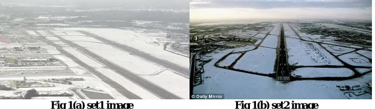
In this research work, an aerial digital images can be gathered from various background situations with 7.2MP resolution. The original images where resized to a lower resolution of approximately 457x630 pixels so the algorithms chosen can process them more efficiently.
Figure 1 (a) and (b) shows the image datasets used for this study.
Fig 1(a) set1 image Fig 1(b) set2 image
III.PROPOSED METHODOLOGY
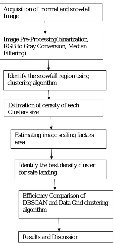
The proposed methodology design shown in fig(2) can be used for analysing , clustering and comparing the image dataset sequence for a step by step process. The methodology to be followed is wrecked along into the following steps. 1. Acquisition of normal and snowfall Image : The primary step for the proposed methodology begins with the Aerial Image Acquisition . The image acquisition can be used to load the aerial images can be gathered from various flight runway area with snowfall as background situations.
2)Image Pre-Processing : Binarization of Image : Binarization is used to convert true color aerial snowfall images into 1’s and remaining area other than snowfall are considered as 0’s format.
RGBtoGrayConversion In photography and computing, a grayscale digital image is an image in which the assessment of each pixel is on its own sample, that is, it carries only intensity information.
Image Filtering:The median filter is a nonlinear digital filtering technique, often worn to eliminate noise from an image or signal.
3) Identify the snowfall region using clustering algorithm: After pre-processing the snowfall image, the proposed methodology can be implemented in order to identify the snowfall region using DBSCAN and data grid clustering algorithms.
4) Estimation of density of each Clusters size : After clustering the snowfall area, then there is a need to determine the density of each cluster size with respect to total number of black pixels(1’s) in the snowfall region.
5) Estimating image scaling factors : After estimating the density of each cluster, then implement the scaling factors to identify the width, length and circumference area of each cluster(landing area).
6) Identify the best density cluster for safe landing : After estimating the total primary coverage area of snowfall, then there is a need to identify the best position for landing the flight in runway area with respect to minimum density region and size..
7) Efficiency Comparison of DBSCAN and Data Grid clustering algorithm :The efficiency of the proposed methodology have been compared with DBSCAN and Data Grid algorithm with respect to memory usage and running time .
Fig 2 proposed methodology
IV.SIMULATION RESULTSANDDISCUSSION
Binarization process aims to decrease the presence of unwanted data or pixels and preserve only the desired data in the document images. Complexity reduction achieved by the binarization process is a major motivation for including it in
Image Pre-Processing(binarization,
RGB to Gray Conversion, Median
Filtering)
Identify the snowfall region using
clustering algorithm
Estimation of density of each
Clusters size
Estimating image scaling factors
area
Identify the best density cluster
for safe landing
Efficiency Comparison of
DBSCAN and Data Grid clustering
algorithm
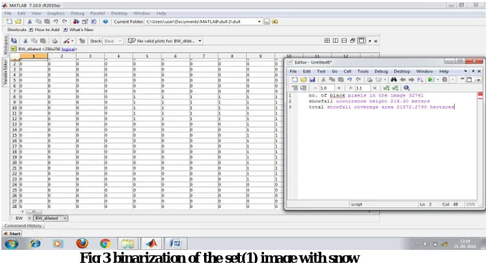
virtually all documents processing area Moghaddam et al. [10].In our proposed methodology decrease the presence of unwanted white pixels(0’s) in the snowfall region and compute the total black pixels(1’s) in the snowfall region. After image binarization, the following figure(3) Display or show the total estimation of snowfall image as (1’s) and noise pixels (0’s) next to the binary version .
After read the RGB snowfall image, then convert the snowfall image into binary image using IM2BW command.
BW = Imbinarize(I);
BW = IM2BW(R,G,B,LEVEL)
The output image BW replaces all pixels in the input image with luminance greater than level (255) with the value 1 (white) and replaces all other pixels with the value 0 (black). Specify level in the range [0,1].
Fig 3 binarization of the set(1) image with snow
The proposed RGB image represented in the figure(3) and (4) have been converted to gray scale image using the grey level range starts between 0 to 255 level. If the value greater than 0’s are considered as snowfall region with black pixels(1’s) and less than 0’s being noise area.
After gray scale conversion, the corresponding total number of snowfall black pixels(1’s) are other noise data are automatically shown. If the value greater than 0’s are considered as snowfall region with black pixels(1’s) and less than 0’s being noise area. The following figure(4)and (5) represents to Read RGB image into the workspace.
fig (5) Gray scale image
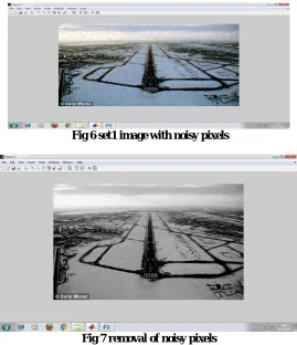
To estimate the median values sort all the pixel values into mathematical order and then replacing the considered pixel by the median (middle) pixel value. The following fig(6) and (7) represents the original RGB image going to be filtered.
Fig 6 set1 image with noisy pixels
If one takes the median value it will be either 0 or 255 which is again noisy. To solve this problem, the mean of the selected window is found and the processing pixel is replaced by the mean value .
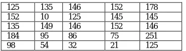
The following table(1) represents the intensity values and calculation of median value for the set1 image with snow.
Table I Representation of intensity value for snowfall image
MEDIAN VALUE:110
The foremost scheme of the median filter is to run during the signal entry by entry, replacing each entry with the median of adjacent entries. The prototype of neighbors is called the "window", which slides, entry by entry, over the entire signal.
V. CONCLUSION & FUTURE WORK
The proposed research work focuses on various aerial images that can be gathered as research data, from various flight run way occurrence area with heavy, medium and ordinary snowfall as background situations. The main objective is to acquiring the research data and focus on image pre-processing techniques(image binarization, gray-scale conversion and filtering).Secondary objective is to convert the true scale image into binary image using the binarization technique. Regarding the possibilities of future research on the same lines, the current research can be extended to and evaluate the work in the following areas:
1. Extend the system to estimate the density of snowfall region and estimate the total coverage of snowfall region. 2. Extend the proposed methodology focal length of the camera above 100mm.
This promises a great scope for further research on these lines.
REFERENCES
[1]. Density-Based Clustering Algorithms, research work, Lahore College for Women University Lahore, Pakistan.
[2]. Pasi Fränti. Number of clusters (validation of clustering), Speech and Image Processing Unit School of Computing University of Eastern Finland. [3] R. Agrawal, J. Gehrke, D. Gunopulos, and P. Raghavan.
Automatic subspace clustering of high dimensional data for data mining applications. SIGMOD'98.
[4]. C. Rother, V. Kolmogorov, T. Minka, and A. Blake. Cosegmentation of image pairs by histogram matching – incorporating a global constraint into mrfs. In CVPR, 2006.
[5]. Russell, W. T. Freeman, A. A. Efros, J. Sivic, and A. Zisserman. Using multiple segmentations to discover objects and their extent in image collections. In CVPR, 2006.
[6]. J. Shawe-Taylor and N. Cristianini. Kernel Methods for Pat-tern Analysis. Camb. U. Press, 2004. [7]. J. Shi and J. Malik. Normalized cuts and image segmentation. IEEE Trans. PAMI, 22(8):888–905, 1997. [8]. J. Winn and N. Jojic. Locus: learning object classes with unsupervised segmentation. In ICCV, 2005. [9]. L. Xu, J. Neufeld, B. Larson, and D. Schuurmans. Maximum margin clustering. In NIPS, 2005.
[10].K. Mumtaz1 and Dr. K. Duraiswamy. A Novel Density based improved k-means Clustering Algorithm – Dbkmeans. (IJCSE) International Journal on Computer Science and Engineering, Vol. 02, No. 02, pp. 213-218, 2010.
[11]. Duchenne, I. Laptev, J. Sivic, F. Bach, and J. Ponce. Automatic annotation of human actions in video. In ICCV, 2009.
[12]. P. F. Felzenszwalb and D. P. Huttenlocher. Efficient graphbased image segmentation. International Journal of Computer Vision, 59,2004. [13].M. X. Goemans and D. Williamson. Improved approximation algorithms for maximum cut and satisfiability problems using semidefinite programming. Journal of the ACM, 42:1115–1145, 1995.
[14].T. Hastie, R. Tibshirani, and J. Friedman. The Elements of Statistical Learning. Springer-Verlag, 2001.
125 135 146 152 178
152 10 125 145 145
135 149 146 152 146
184 95 86 75 251