COMBINING DESIGN METHODOLOGIES
FOR THE DEVELOPMENT OF A PRACTICAL AND
EFFECTIVE APPROACH TO EROSION CONTROL SYSTEMS
03-02-06-0102 EA 001 (Vot:74179)
Prof. Dr. Noraieni Hj. Mokhtar Dr. Nurly Gofar
Azman Kassim Faculty of Civil Engineering, Universiti Teknologi Malaysia
ABSTRACT
Erosion and slope failure has become common geotechnical problem in tropical region such as Malaysia. This report presents the combining design methodologies for the development of a practical and effective approach to erosion control systems. The study is aimed to apply bio-engineering techniques, using concrete / polymer and incorporating vegetated systems for erosion control and slope stabilization. Three research approaches are adopted namely field monitoring, laboratory modeling, and numerical simulation. Measurements of the rainfall amount, surface runoff, soil loss, pore-water pressure and the evaluation on the effectiveness of the vegetation covers applied on the slope surface are the key subjects to the study. However, the sediment control system was not fully implemented due to the overdue date of completion of the project. Nonetheless, the study would be continued and the funding of the research would be borne by other research grants proposed.
ABSTRAK
Hakisan tanah dan kegagalan cerun telah menjadi masalah geoteknik yang rutin di kawasan tropikal seperti Malaysia. Laporan ini membentangkan kaedah-kaedah kombinasi rekabentuk bagi menghasilkan satu pendekatan yang praktikal dan berkesan untuk sistem pengawalan hakisan tanah. Kajian ini bermatlamat untuk mengaplikasikan teknik kejuruteraan-bio, menggunakan konkrit / polimer dan menerapkan sistem tumbuh-tumbuhan untuk pengawalan hakisan tanah dan penstabilan cerun. Tiga pendekatan kajian telah digunakan iaitu pengawal-seliaan tapak, pemodelan makmal, dan simulasi komputer. Pengukuran jumlah air hujan, air larian permukaan, kehilangan tanah hakisan, tekanan air liang dan penilaian tentang keberkesanan penutup tumbuh-tumbuhan yang ditanam di permukaan atas cerun merupakan perkara-perkara penting dalam kajian ini. Bagaimanapun, sistem pengawalan mendapan tidak diimplimentasikan sepenuhnya disebabkan oleh pelengahan tarikh penyiapan projek ini. Walau bagaimanapun, kajian ini akan diteruskan jika peruntukan untuk kajian ini dapat dilanjutkan atau dimasukkan dalam cadangan peruntukan kajian yang baru.
1.0 INTRODUCTION
Tropical regions such as Malaysia are well-known with their mountainous terrain with distinctive climatic changes through out the year. Under this situation, the slope failure incidents are often triggered by prolonged wet-and-dry climatic cycles. Many steep slopes or embankments along the highway or residential area are prone to sudden failure shortly after intense rainstorms. These incidents have caused casualties and millions of dollars of damage to public and private properties every year.
Many studies on slope hydrology (either in unsaturated soil or saturated soil) have been carried out for the past few decades. In the early study, Lumb (1962) had significant contribution in determining the wetting front of unsaturated zone. Other recent studies in unsaturated soils include Fredlund and Rahardjo (1988-2004), Zhan and Charles (2004), Xu (2004) etc. For studies about seepage in saturated zone, Budhu et al. (1995), Hagerty et al. (2001), Mishra and Singh (2005) etc. have done comprehensive investigation in the field. Nanyang Technological University, Singapore (2000) has published a monograph which highlighted the mechanism in rainfall-induced slope failures. However, the mechanism of slope failure due to rainfall pattern still yet to be fully understood due to limited research has been carried out to establish the relationship between rainfall, erosion, and slope stability.
2.0 OBJECTIVES OF THE STUDY
The study is aimed to propose a practical and effective approach to erosion control. In order to fulfill the overall objectives, specific objectives are identified as follow: i) To investigate the suitability of bio-engineering component in sloping
environment.
ii) To compare the effectiveness of bio-engineering as a method of prevention for erosion-induced slope failure.
iii) To identify the advantages and disadvantages of the application of bio-engineering in slope stability.
3.0 SCOPE AND APPROACHES OF STUDY
The scope of the study covers the understanding in mechanism of erosion-induced slope failure and the development of a practical and effective approach to erosion control; system. Therefore, erosion, slope stability, and bio-engineering are the key subjects in this study. Three approaches are adopted in this study namely field monitoring, laboratory modeling, and numerical modeling. One sloping field is selected for monitoring purpose and it is located at Bukit Cerapan, UTM, Skudai. Applications of bio-engineering components are studied for their effectiveness for soil erosion prevention as compared to the bare surface and conventional method.
4.0 SIGNIFICANCE OF THE STUDY
5.0 LITERATURE REVIEW
In this chapter, some literatures related to the erosion, vegetation cover and slope stability analysis are discussed. Some of the research gaps are identified which initiate the present study to be carried out.
5.1 Soil Erosion
Erosion is the displacement of solids (soil, mud, rock and other particles) by the agents of wind, water or ice, by downward or down-slope movement in response to gravity or by living organisms (in the case of bioerosion). An example of soil erosion is shown in Photo 1. Erosion is distinguished from weathering, which is the decomposition of rock and particles through processes where no movement is involved, although the two processes may be concurrent.
Photo 1: Soil erosion
depends on a combination of many factors, including the amount and intensity of precipitation, the texture of the soil, the gradient of the slope, ground cover (from vegetation, rocks, etc.) and land use. The first factor, rain, is the agent for erosion, but the degree of erosion is governed by other factors. The first three factors can remain fairly constant over time. In general, given the same kind of vegetative cover, one can expect areas with high-intensity precipitation, sandy or silty soils and steep slopes to be the most erosive. Soils with a greater proportion of clay that receive less intense precipitation and are on gentle slopes tend to erode less.
The factor that is most subject to change is the amount and type of ground cover. When fires burn an area or when vegetation is removed as part of timber operations or building a house or a road, the susceptibility of the soil to erosion is greatly increased. In generally, soil erosion is governed by factors as stated below:
i) Lack of protection against raindrop impact, ii) Decreased aggregate stability,
iii) Long and steep slopes,
iv) Intense rainfall or irrigation events when plant or v) Residue cover is at a minimum,
vi) decreased infiltration by compaction or other means.
5.2 Erosion Prediction
Before any conservation and remedial works can be carried out, it is crucial to perform an analytical or numerical model to predict the volume of soil loss. Effective control of soil erosion requires an ability to quantitatively predict the amount of soil loss which would occur under alternate management strategies and practices. Before selecting an approach to modeling, the objective must be specified, whether prediction or explanation. Appropriate model type is chosen based on the economical, technical, and instrumentation constraints.
broad areas under various cropland and rangeland management techniques. Some are purely statistical models, others mechanistic. Three of the more widely used methods
Table 1: Common types of soil loss models
Type Description
Physical Scaled-down hardware models usually built in the laboratory; need to assume dynamic similitude between model and real world.
Analogue Use of mechanical r electrical systems analogous to system under investigation, e.g. flow of electricity used to simulate flow of water.
Digital
(a)physically-based
(b)Stochastic
(c) Empirical
Based on use of digital computers to process vast quantities of data.
Based on mathematical equations to describe the processes involved in the model, taking account of the laws of conservation of mass and energy.
Based on generating synthetic sequences of data from the statistical characteristics of existing sample data, useful for generating input sequences to physically-based and empirical models where data only available for short period of observation.
Based on identifying statistically significant relationships between assumed important variables where a reasonable data base exists. Three types of analysis are recognized.
block-box: where only main inputs and outputs are studied;
grey-box: where some detail of how the system works is known;
white-box: where all details of how the system operates are
in North America are the Universal Soil Loss Equation (USLE), Revised Universal Soil Loss Equation (RUSLE) and Water Erosion Prediction Project erosion model (WEPP). Much of the research on erosion rates is directed towards supporting or fitting these competing models. In particular much of the mineland erosion literature is solely focussed on fitting or improving RUSLE parameters. Aside from a few new deterministic gully erosion models, these models do not consider gully erosion which mostly due to difficulties in modelling, and partly because gullies are often repaired in agricultural, forestry, or mining environments.
Because there is a wide discrepancy between predicted and observed erosion rates, models are better as research tools than as public policy and regulatory instruments or for prescriptive design measures for constructed landforms. But some models may provide useful guidance for the design engineer if adequately calibrated and verified for local conditions and if the design accounts for the uncertainty. There are several types of model available for soil loss prediction. Table 1 shows common types of soil loss models.
5.3 Erosion Control
Erosion control is aimed to decrease exposed soil and make it less susceptible to wind or rain transport. Soil erosion can be avoided by three ways:
i) Maintaining a protective cover on the soil, ii) Creating a barrier to the erosive agent,
iii) Modifying the landscape to control runoff amounts and rates.
5.4 Universal Soil Loss Equation (USLE)
annual records of erosion on plots and small catchments at 46 stations on the Great Plains. Wischmeier and Smith's aim (1960 and 1978) was to establish an empirical model for predicting erosion on a cultivated field so that erosion control specialists could choose the kind of measures needed in order to keep erosion within acceptable limits given the climate, slope and production factors.
While newer methods are now becoming available, most are still founded upon principles introduced by the USLE; thus, understanding those principles is quite important. USLE states that the field soil loss in tons per acre, A, is the product of five causative factors. Erosion is seen as a multiplier of rainfall erosivity (the R factor, which equals the potential energy); this multiplies the resistance of the environment, which comprises K (soil erodibility), LS (the topographical factor), C (plant cover and farming techniques) and P (erosion control practices). Since it is a multiplier, if one factor tends toward zero, erosion will tend toward zero. This erosion prediction equation is composed of five sub-equations:
A = R × K × LS × C × P
i) R, the rainfall erosivity index, equals E, the kinetic energy of rainfall, multiplied by I30 (maximum intensity of rain in 30 minutes expressed in cm per hour). This index corresponds to the potential erosion risk in a given region where sheet erosion appears on a bare plot with a 9% slope.
ii) Soil erodibility, K, depends on the organic matter and texture of the soil, its permeability and profile structure. It varies from 70/100 for the most fragile soil to 1/100 for the most stable soil. It is measured on bare reference plots 22.2 m long on 9% slopes, tilled in the direction of the slope and having received no organic matter for three years.
iii) LS, the topographical factor, depends on both the length and gradient of the slope. It varies from 0.1 to 5 in the most frequent farming contexts in West Africa, and may reach 20 in mountainous areas.
bare soil to 1/1000 under forest, 1/100 under grasslands and cover plants, and 1 to 9/10 under root and tuber crops.
v) P is a factor that takes account of specific erosion control practices such as contour tilling or mounding, or contour ridging. It varies from 1 on bare soil with no erosion control to about 1/10 with tied ridging on a gentle slope.
In practice, in order to work out the production systems and erosion control measures to be set up in a given region, the first step is to determine the risk of erosion from rainfall, then the degree of erodibility. A series of trials then follow to determine a factor C on the basis of desired rotations, farming techniques and erosion control practices; finally, the length and gradient are calculated for the slope to be obtained through erosion control structures in order to reduce land loss to a tolerable level (1-12 t/ha/yr). It is thus a practical model for an engineer with few data to use as a less empirical basis for finding rational solutions to practical problems.
5.5 Limitations of the USLE Model
Even though USLE appear to be the greatest acceptance model, it is exposed to certain extend of limitations as well:
i) The model applies only to sheet erosion since the source of energy is rain; so it never applies to linear or mass erosion.
ii) The type of countryside: the model has been tested and verified in peneplain and hilly country with 1-20% slopes, and excludes young mountains, especially slopes steeper than 40%, where runoff is a greater source of energy than rain and where there are significant mass movements of earth.
iii) The type of rainfall: the relations between kinetic energy and rainfall intensity generally used in this model apply only to the American Great Plains, and not to mountainous regions although different sub-models can be developed for the index of rainfall erosivity, R.
erosivity but the volume of runoff (Williams 1975).
v) Lastly, a major limitation of the model is that it neglects certain interactions between factors in order to distinguish more easily the individual effect of each. For example, it does not take into account the effect on erosion of slope combined with plant cover, nor the effect of soil type on the effect of slope.
5.6 Modified Universal Soil Loss Equation (MUSLE)
The Modified Universal Soil Loss Equation follows the structure of the Universal Soil Loss Equation (USLE), with the exception that the rainfall factor is replaced with the runoff factor. The equation calculates soil loss for a storm within a watershed that does not exceed 5 square miles. The structure of the MUSLE is
A = R × K × LS × C × P
where
R = a(Q × qp )b Note: a = 11.8
b = 0.56
Q = the storm runoff volume in m3 qp = the peak runoff rate in m3 / sec
5.7 Vegetation Cover
important project planning, design, and agency permitting periods.
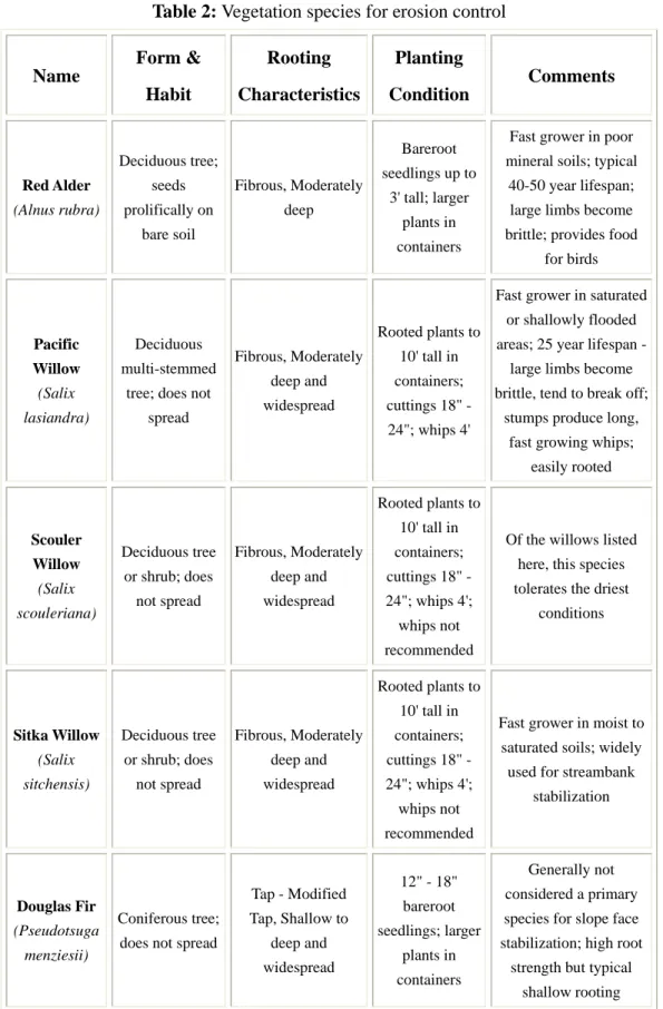
When properly installed and maintained, vegetation can actually protect slopes by reducing erosion, strengthening soil, and inhibiting landslides which increase general slope stability. The use of vegetation to manage erosion and protect slopes is relatively inexpensive, does not require heavy machinery on the slope, establishes wildlife habitat, and can improve the aesthetic quality of the property. There are large numbers of vegetation species available for erosion control. Each vegetation species has its special characteristics and suitability for certain soil type. Some of the vegetation species and its characteristics are shown in Table 2.
5.8 Slope Stability Analysis
FEEMBILG etc.
Table 2: Vegetation species for erosion control
Name Form & Habit Rooting Characteristics Planting Condition Comments Red Alder (Alnus rubra) Deciduous tree; seeds prolifically on bare soil Fibrous, Moderately deep Bareroot
seedlings up to
3' tall; larger
plants in
containers
Fast grower in poor
mineral soils; typical
40-50 year lifespan;
large limbs become
brittle; provides food
for birds Pacific Willow (Salix lasiandra) Deciduous multi-stemmed
tree; does not
spread
Fibrous, Moderately
deep and
widespread
Rooted plants to
10' tall in
containers;
cuttings 18" -
24"; whips 4'
Fast grower in saturated
or shallowly flooded
areas; 25 year lifespan -
large limbs become
brittle, tend to break off;
stumps produce long,
fast growing whips;
easily rooted Scouler Willow (Salix scouleriana) Deciduous tree
or shrub; does
not spread
Fibrous, Moderately
deep and
widespread
Rooted plants to
10' tall in
containers;
cuttings 18" -
24"; whips 4';
whips not
recommended
Of the willows listed
here, this species
tolerates the driest
conditions
Sitka Willow
(Salix
sitchensis)
Deciduous tree
or shrub; does
not spread
Fibrous, Moderately
deep and
widespread
Rooted plants to
10' tall in
containers;
cuttings 18" -
24"; whips 4';
whips not
recommended
Fast grower in moist to
saturated soils; widely
used for streambank
stabilization
Douglas Fir
(Pseudotsuga
menziesii)
Coniferous tree;
does not spread
Tap - Modified
Tap, Shallow to
deep and
widespread
12" - 18"
bareroot
seedlings; larger
plants in
containers
Generally not
considered a primary
species for slope face
stabilization; high root
strength but typical
characteristics in thin
coastal soils; can be
planted in stands in
slope crest greenbelts;
good eagle and osprey
perch and nest trees;
potential for wind throw
in thin or disturbed soils
Northern Black Cottonwood (Populus trichocarpa) Deciduous; does not spread
Fibrous, Shallow to
deep, and
widespread,
extensive
Rooted plants to
10' tall in
containers;
cuttings 18" -
24"; whips 4' tall
Fast grower in moist to
saturated soils; also
widely used for
streambank stabilization; potential wind throw Red-Osier Dogwood (Cornus stolonifera or Cornus sericea) Deciduous
shrub; does not
spread
Fibrous, shallow
Rooted plants to
6' tall in
containers;
bareroot &
cuttings 18" -
24" tall
Attractive shrub that
produces bright red
stems Black Twinberry (Lonicera involucrata) Deciduous
shrub; does not
spread
Fibrous, shallow
Rooted plants to
6' tall in
containers;
bareroot 18" -
24" tall
Produces yellow twin
flowers and black twin
berries; some success
reported from cuttings
Ninebark
(Physocarpus
capitatus)
Deciduous
shrub; does not
spread
Fibrous, shallow
Rooted plants to
6' tall in
containers;
bareroot 18" -
24" tall
Produces masses of tiny
white flowers which
change to reddish seed
clumps Cascara (Rhamnus purshiana) Deciduous tree/shrub; does not spread
Tap - Moderately
deep
Rooted plants to
6' tall in
containers;
bareroot 18" -
24" tall
Shiny black berries are
favored by Cedar
Waxwings Salmonberry (Rubus spectabilis) Deciduous shrub; spreads by underground
runners to form
thickets
Fibrous, Shallow
Rooted plants to
4' tall in
containers;
bareroot 6"-8"
tall; cuttings
18"-24"
Spreads quickly once
established; berries
provide food for a
6.0 METHODOLOGY
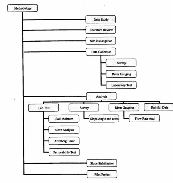
At the early stage of the study, some literatures were reviewed for background study. Interviews and consultations to the local professions in the study area of erosion and slope stability were carried out. Three research approaches were then adopted namely field monitoring, numerical modeling, and laboratory modeling. The details of each approach are discussed in the following topic.
6.1 Project Design Considerations
Factors taken into the design considerations include the following: • Anchorage system
• Slope gradient • Slope length • Soil conditions
6.2 Project site selection
6.2.1 PILOT SCALE TEST FOR REHABILITATION AND STABILIZATION
OF RIVERBANK
1st Test Site: Riverside FKA
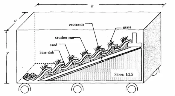
• Use of Zoysian net and vegetated systems • Use of Sine-Slab with vegetated systems
• Use of Sine-Slab incorporated with gabion systems
Photo 1 Pilot Site Study-UTM Campus ground
COMPARISON STUDY USING CONCRETE STRUCTURES, NETTING AND VEGETATED SYSTEMS FOR HILLSLOPE STABILIZATION
2 nd Test Site
Kolei 8, UTM Campus, Skudai
• Use of Sine-Slab with vegetated system
Figure2 Site layout (zone separation)
Figure2 & 3 Test Site preparation
Phot 6 & 7 River gauging
Photo 8 & 9 Survey work
7.0 DATA COLLECTIONS AND EXPERIMENTAL RESULTS 7.1 Soil data from Sieve Analysis
Figure 3.1
Figure 3.2
Test site 2 Hillslope College 8
Figure 3.4
7.2 Meteorological data
We have also obtained some meteorological data for one year (Jan-Dec 2004) on the rainfall and the recording station was based at Arked Cengal, UTM Campus as per attached.
7.3 Survey data
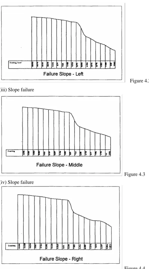
(i) River profile
(ii) Slope failure
Figure 4.2 (iii) Slope failure
Figure 4.3 (iv) Slope failure
Figure 5 Layout Plan
8.0 UTILISATION OF HUMAN RESOURCES
8.1 Project Team: Erosion control at Riversides
The project team members comprise mainly researchers at Fakulti of Civil Engineering and the undergraduate and undergraduate students form the supporting team. An industrial component team supports for the Pilot project at the test site.
8.2 Project Team: Erosion an sediment control at Hillslope
Figure 8
9.0 Research activities in 2006
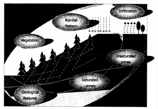
Figure 9 Research Concept
9.1 Research Objectives
1. To characterize the shear strength properties of typical residual soil(s) with present of geological discontinuities.
2. To describe the mechanics of rainwater flow through the vadose zone of the residual soil(s).
3. To establish saturated and saturated flow models for the residual soil under lypical flux boundary conditions.
4. To investigate pore water distributions for the soil(s) during wet and dry periods.
5. To determine the mechanism of rainfall-induced hillslope failure and to identify factors which contribute to the mechanism.
6. To produce useful relationships for preliminary guideline for assessment of stability against rainfall-induced failure.
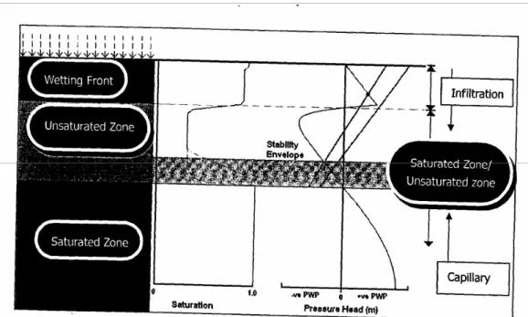
Figure 10 Slope Stability Framework
Figure 12 Field test set-up
9.2 (i) Study visits and Consultations
There was a trip to National Soil erosion Research Center (NASEC), UiTM on 17th January 2006 in order to have discussion with Prof Dr. Roslan. Prof Dr. Roslan is the director of NASEC and has involved in soil erosion studies for many years. The benefits from the visit were acquisition of the information about erosion problems in Malaysia and their on-going research projects. On the same day, there was a trip to UPM and UM to have discussion session with Prof Dr. Mohd Amin Mohd Sam and Prof Faisal Ali respectively. Prof Dr. Mohd Amin is an expert in vetiver cover, while Prof Faisal Ali is majoring in unsaturated soil mechanic. The main purpose of the visit was to have an overview about the on-going research in the nation.
A trip was organized to NTU, Singapore in June 2006 to have a discussion with Prof. Dr. Harianto Rahardjo. Prof Dr. Harianto Rahardjo is an expert in unsaturated soil mechanic and has done many studies in rainfall-induced slope failure. There was a visit to their laboratory to have an overview on their laboratory set-up.
Besides, the research team members have attended a course organized by NASEC on 26 July 2006. The purpose of the course is to study about the erosion assessment method by using ROM and ROSE Scales.
Photo 11: Visit to Prof Dr. Harianto Rahardjo, NTU, Singapore
Photo 12: Site visit at Bukit Cerapan by Prof Dr. Roslan
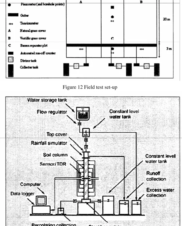
9.3 Field Monitoring
investigate the soil profile underneath the slope. Photo 5 shows the boring works at the study area. Soil samples were taken from the field and their properties were measured in laboratory. Some soil properties were measured at the site too such as soil permeability. In respect of monitoring instrumentations, the slope was instrumented with 36 tensiometers for negative pore-water pressure measurement. Each plot was installed with nine units of tensiometers with three each at the crest, middle and toe respectively. A total of four plots were constructed with different vegetation covers. The vegetation covers applied at each plot were cow grass, vetiver grass, modified sine-slab, and barren. A schematic diagram for one of the plot is illustrated in Figure 1. A rain gauge is installed at the study area to record the rainfall data for entire study area.
Figure 14: Schematic diagram for one instrumented plot
9.4 Numerical Modeling
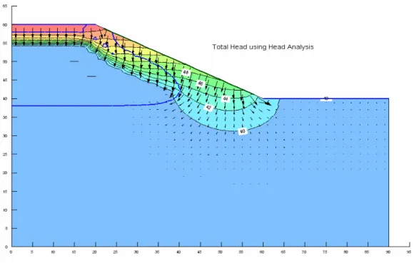
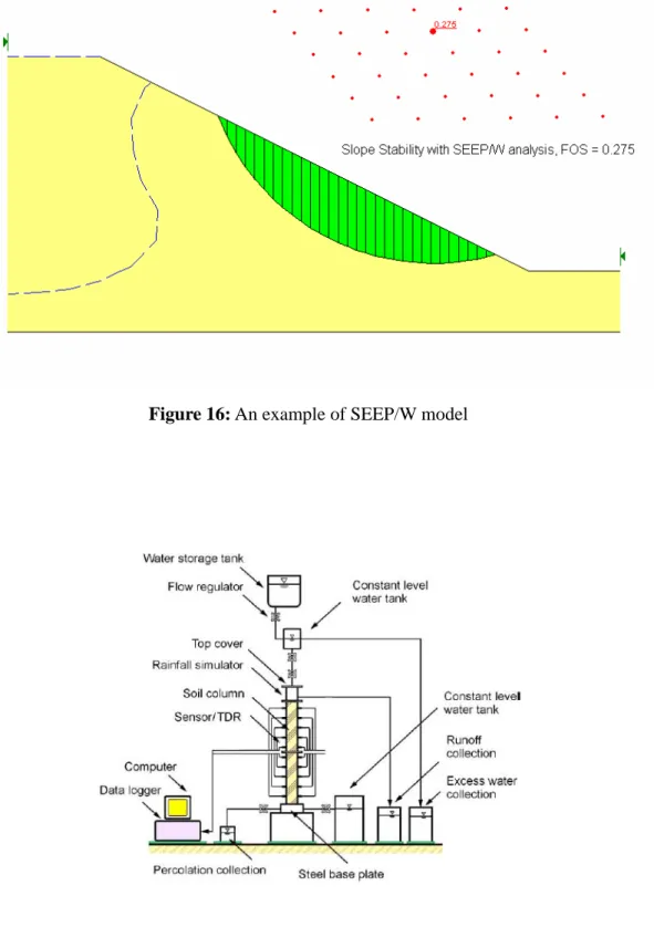
A finite element code SEEP/W was used to analyze the seepage in the slope. Seepage force beneath the ground surface could eventually cause the internal erosion. Therefore, it is essential to analyze the seepage due to the rainfall infiltration in order to assess the slope stability. Based on the seepage force and pore-water pressure profile generated from SEEP/W, the results were exported to SLOPE/W for computation of the factor of safety (FOS). An example of SEEP/W model and SLOPE/W models are illustrated in Figure 2 and 3.
9.5 Laboratory Modeling
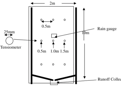
Soil column model is constructed for the purpose to monitor the changes in saturation (water content) and suction of the soils responses to rainfall infiltration and capillary effect from groundwater. Due to the infiltration in an unsaturated soil is a highly nonlinear and complex problem, laboratory study is a convenient and practical approach to verify the results from numerical modeling. Laboratory study also offers the advantages that all the related conditions and soil properties can be carefully controlled when compared with the field tests (Yang et. al., 2004).
2m
10m 0.5m
0.5m 1.0m 1.5m 25mm
Tensiometer
Rain gauge
A schematic diagram of the soil column apparatus is shown in Figure 4. The soil column is constructed for 1m high. The body of the cylinder was made of acrylic transparent tubes with a 5-mm-thick wall and 190-mm internal diameter. Two column lengths, i.e., 2000mm and 500mm are fabricated for easy combination and filling of unsaturated and saturated soils.
Two types of threaded holes of different sizes located at the soil column wall with 0.1m interval respectively were designed and fabricated. One type of threaded hole was provided for the installation of tensiometer probes (ceramic cups), while another type of threaded hole was provided to install moisture probes. The holes that were not in use during the experiment were sealed with threaded plugs. This method is similar to the method proposed by Yang et al. (2004).
Figure 16: An example of SEEP/W model
10.0 CONCLUSIONS
The research project was able to explore the various research methodologies for understanding the mechanism of slope failure as field tests, computer, and laboratory modeling. Further data collection are needed to be analysed to bring to findings in relation to parameters contributing to erosion namely, the soil factor, slope, rainfall: a frequent contributing factors towards the common phenomena in the tropical regions. Various models have been explored. The sediment control system was not fully implemented due to the overdue date of completion of the project and the extension of the duration of the project was not allowed by MOSTI. Nonetheless, the PhD thesis would be continued and the funding of the research would be borne by other research grants proposed.
11.0 ACKNOWLEDGEMENT
The authors wish to thank MOSTI for sponsoring this project. Special thanks to everyone who has been involved in the project and research support staff from Research Management Centre, Universiti Teknologi Malaysia.
12.0 PUBLICATIONS
1. A. Kassim, N. Gofar, N.H. Mokhtar, L.M. Lee, 2006. The Effect of Transient State Rainfall on Stability of a Residual Soil Slope. International Conference on Slopes, Malaysia 2006, Kuala Lumpur, 6-9 August
2. N. Gofar, L.M. Lee & A. Kassim, 2006. Effect of Surface Boundary Condition on Rainfall Infiltration. Jurnal Teknologi B, Penerbit UTM (full paper reviewed in April 2006)