Longitudinal Valley Suture
Thesis by
J. Bruce H. Shyu (Hao-Te Hsu)
In Partial Fulfillment of the Requirements for the Degree of
Doctor of Philosophy
California Institute of Technology Pasadena, California
2006
© 2006
Acknowledgments
Seven years ago when I was writing my Master’s thesis, I considered the acknowledgments to be the most important part of that thesis. Today, I still believe that this acknowledgment is the most important section of this dissertation. However, this acknowledgment could also be the section that is most difficult to write, since I may have to write a whole new thesis in order to thank everyone that has helped me through these years.
First of all, I want to express my utmost gratitude to my advisor, Kerry Sieh, for his generous support and guidance through the years, and his endless enthusiasm for the neotectonics of Taiwan, earth science, and the sciences in general. Without his intuitive decision to work on the general neotectonic picture of Taiwan after the earthquake, his meticulous working style in the field, and his painstaking corrections of my writing, this thesis would have never been produced. Furthermore, besides having learned tremendously from him in the scientific realm, I feel that I have benefited even more from countless casual discussions, whose topics have ranged from societal and political issues to the environment and even to how best to enjoy life. All of these shaped me not only into a scientist, but also into a better person, with a more international point of view.
which have long been my weakest points. Most of my knowledge about geodesy was obtained from valuable discussions with Mark, and I have learned a lot from Joann both in her classes and in discussions with her.
I would also like to thank all of the faculty members here in the GPS Division, Caltech, for teaching me so much during these six and a half years. In particular, I want to thank Dianne Newman, the advisor for one of my first-year propositions. Knowing nothing about microbiology at that time, I am grateful for her giving me the opportunity to work in her lab and for enlightening me on this subject, as well as for her understanding and encouragement of my decision to return to geology afterward. I have also learned enormously from John Eiler and Jess Adkins, advisors for my other first-year proposition, as well as from Joe Kirschvink and Brian Wernicke. I also want to thank George Rossman and Yuk Yung for their encouragement and support.
This thesis would not have come to exist without the tremendous help of my Taiwanese friends and colleagues. Yue-Gau Chen, the superman, is the most important unsung hero of this thesis. Not only did he provide all of the logistic and financial support, but he was also always there when I needed help. He has been a mentor, a colleague, and most importantly, a friend of mine throughout the years. Wen-Shan Chen provided the financial support for my Hsiukuluan River terrace investigations and taught me a lot about the Coastal Range geology. Typhoon Huang took care of the logistics and dealt with the landowners in eastern Taiwan. I am also grateful for the encouragement and support of Leh-Chyun Wu, Ping-Mei Liew, Ching-Hua Lo, Sun-Lin Chung, and other professors in National Taiwan University, without which I would not have finished this thesis.
Kuang-Yin Lai, Ray Chuang, and other students of Yue-Gau’s group helped with most of my field work in western Taiwan and some of the work in eastern Taiwan. Chung Huang, Po-Nong Li, Shin-Hua Huang, and Chih-Hao Chen helped the investigations and measurements in the Hsiukuluan River area. Yung-Chuan Chen helped me greatly in the Peinanshan area, and my works in the terrace pits were helped significantly by Barry Chih-Cheng Yang, I-Chin Yen, Neng-Wei Huang, and other students from Wen-Shan’s group. Takuya Watanuki, who passed away this summer in a tragic accident, assisted me on several field trips in eastern Taiwan, and I have benefited from our discussions and enjoyed working in the field with him. I will always miss such a great friend.
Many local residents in eastern Taiwan have assisted me in the field. I want to thank Boss Hsieh of Rueisuei and Boss Huang of Lungtien for helping me dig the pits on the river terraces, Mr. Wu of Tewu for providing his own land and for arranging other suitable locations for the pit-digging, Mr. Hsieh of Chimei for providing his land for the pit-digging as well as for his hospitality in providing meals for me when I was in the area, and Reverend Pai and the Bunun Cultural and Educational Foundation for providing accommodation and their land and backhoe for the pit-digging. I want to thank in particular Teacher Huang and Teacher Cheng, the owner of the “House under the Hill” of Rueisuei, for their hospitality in providing me a warm, cozy and welcoming shelter in the field. Every time when I was heading toward the “House under the Hill,” I felt as if I was heading home.
bathymetric data. Michaele Kashgarian of the Center for Accelerator Mass Spectrometry, at Lawrence Livermore National Laboratory, performed the radiocarbon dating of my charcoal samples from the river terraces. Several chapters of this thesis were improved significantly by the critical reading of many reviewers, including Hao-Tsu Chu, Thomas Fumal, Isabelle Manighetti, and Robert Yeats. Caltech proofreaders have provided valuable comments on the grammar and the overall consistency of this thesis, and Simon LeVay kindly helped me on the grammar of this acknowledgment.
Serena Chung, Wei-Hsin Gu, Hung-Te Hsieh, Yu-Ting Huang, I-Ren Lee, Hsuan-Tien Lin, Ming-Shr Lin, Miao-Ling Lu, Mortada Mehyar, Victor Shih and Vanessa Lin, Borching Su, Bruce Tai, Tzer-jen Wei, Shau-Ming Wu, and Fu-Ling Yang.
The great working and learning environment at Caltech is produced and kept not only by the intelligent scientists and students, but also by the wonderful group of administrative and technical personnel. I want to thank JoAnne Giberson, Shaun Healy, and Jennifer Yu for keeping the GIS lab running smoothly, Jim O'Donnell and Susan Leising for providing a great library, Michelle Medley, Marcia Hudson, Carolyn Porter, Terry Gennaro, and the late Donna Sackett for their administrative support, and Heather Steele, Sheri Garcia, and other previous secretaries of Kerry’s group, for taking care of everything!
Last but not least, I would like to thank my family. My parents have always been providing me with endless love, belief and encouragement, and I want to thank them for their understanding and support through the years, ever since I decided to transfer from engineering to geology. I also want to thank my brother and sister and in-laws, who are always there for me. And finally, I could have never finished this thesis without the love, care, companionship and support of my beloved wife, Shing-Lin Wang, who, through the years, has been always beside me through the difficulties, stresses, hard work, deadlines, and the occasional joyful achievement. I ascribe everything that I have accomplished to her.
Abstract
The disastrous effects of the 1999 Chi-Chi earthquake in Taiwan demonstrated an urgent need for better knowledge of the island’s potential earthquake sources as well as their neotectonic context. Toward this end, we have utilized digital elevation models of the island to prepare a neotectonic map of Taiwan and proposed a neotectonic model for the orogen. Taiwan’s numerous active faults and folds reveal that the active orogen is a tandem suturing and tandem disengagement of a volcanic arc and a continental sliver to and from the Eurasian continental margin. The collision and suturing in the southern part of the orogen and the post-collisional collapse and extension in the island’s northern and northeastern flanks have produced eleven distinct neotectonic domains. Each domain is defined by a distinctive suite of active structures. In most of the domains, the size of the principal active fault is large enough to produce future earthquakes with magnitudes in the mid-7 range.
Table of Contents
Acknowledgments...iii
Abstract...viii
Table of Contents...x
List of Figures...xiv
List of Tables...xvii
Introduction and Summary of Chapters...1
Chapter 1 Tandem Suturing and Disarticulation of the Taiwan Orogen Revealed by Its Neotectonic Elements...1-1 1.1 Abstract...1-2 1.2 Introduction...1-3 1.3 Neotectonic belts and domains of Taiwan...1-3 1.4 The Taiwan orogen as accreting and disarticulating twin sutures...1-7 1.5 Implications for future earthquake sources...1-14 1.6 Concluding Remarks...1-15 1.7 Acknowledgments...1-17 1.8 References...1-18
Chapter 2 Neotectonic Architecture of Taiwan and Its Implications for Future
Large Earthquakes...2-1 2.1 Abstract...2-2 2.2 Introduction...2-3 2.3 Neotectonic overview of Taiwan...2-8 2.4 Neotectonic domains of Taiwan...2-11 2.4.1 Eastern neotectonic belt...2-13 2.4.2 Western neotectonic belt...2-24
Chapter 3 Re-evaluation of the Surface Ruptures of the November 1951 Earthquake Series in Eastern Taiwan and Their Neotectonic
Implications...3-1 3.1 Abstract...3-2 3.2 Introduction...3-3 3.3 Tectonic background of the Longitudinal Valley...3-6 3.4 The November 1951 earthquake series...3-8 3.5 Re-evaluation of the November 1951 ruptures...3-11 3.5.1 The Chihshang rupture...3-11 3.5.2 The Rueisuei rupture...3-15 3.5.3 The Yuli rupture...3-17 3.5.4 The Yuli rupture and the Longitudinal Valley fault...3-21 3.6 Discussion...3-23
3.6.1 The November 1951 earthquake series: a complex rupture
event...3-23 3.6.2 What is the Yuli fault?...3-26 3.6.3 Implications for seismic hazard assessment...3-28 3.7 Conclusions...3-30 3.8 Acknowledgments...3-31 3.9 References...3-32
Chapter 4 Millennial Slip Rate of the Longitudinal Valley Fault from River Terraces: Implications for Convergence across the Active Suture of
Eastern Taiwan...4-1 4.1 Abstract...4-2 4.2 Introduction...4-3 4.3 General geologic setting...4-7 4.4 River terraces of Hsiukuluan canyon...4-11 4.4.1 Distribution and characteristics...4-11 4.4.2 Age of terraces...4-15 4.4.3 Reconstructions of river patterns in the past...4-17
4.6.1 Shortening across the Longitudinal Valley suture...4-30 4.6.2 Subsurface geometry of the Longitudinal Valley fault: The
evolution of lithospheric sutures...4-35 4.6.3 Long-term uplift rates of the Coastal Range...4-39 4.6.4 Earthquake potential of the Longitudinal Valley fault...4-40 4.7 Conclusions...4-42 4.8 Acknowledgments...4-43 4.9 References...4-44
Chapter 5 Geomorphic Analysis of the Central Range Fault, the Second Major Active Structure of the Longitudinal Valley Suture, Eastern Taiwan...5-1 5.1 Abstract...5-2 5.2 Introduction...5-3 5.3 Geologic setting...5-6
5.4 Geomorphic analysis near the Wuhe Tableland...5-7 5.5 The Central Range fault south of the Taiping River...5-15 5.6 The blind Central Range fault south of Chihshang...5-19 5.7 Discussion...5-20 5.7.1 Geodetic and Seismic Evidence...5-20 5.7.2 Sense of Slip and Slip Rate of the Central Range Fault...5-22 5.7.3 The Evolution of the Longitudinal Valley Suture...5-24 5.7.4 The Central Range Fault and the Uplift of the Central Rang...5-26 5.8 Conclusions...5-27 5.9 Acknowledgments...5-29 5.10 References...5-30
Chapter 6 Neotectonic Geomorphology of Southernmost Longitudinal Valley Fault, Eastern Taiwan, and Its Tectonic Implications...6-1 6.1 Abstract...6-2 6.2 Introduction...6-3 6.3 Tectonic setting...6-6
6.9 Discussion...6-29 6.9.1 The Central Range fault at the southernmost Longitudinal
Valley...6-29 6.9.2 The southern termination of the Taitung Domain...6-30 6.9.3 Stress release of the southernmost Longitudinal Valley fault...6-31 6.9.4 Lichi Formation and the Longitudinal Valley fault...6-32 6.10 Conclusions...6-33 6.11 Acknowledgments...6-35 6.12 References...6-36
List of Figures
Figure 1.1. Map of the active faults and anticlines of the Taiwan orogen...1-4 Figure 1.2. Tandem suturing and tandem disarticulation of Taiwan...1-8 Figure 1.3. Three schematic crustal cross sections across Taiwan...1-9
Figure 2.1. A neotectonic snapshot of Taiwan and adjacent regions...2-4 Figure 2.2. Examples of the geomorphic evidence for active structures...2-7 Figure 2.3. Map of major active faults and folds of Taiwan...2-12 Figure 2.4. Active-tectonic map of the Lutao-Lanyu Domain...2-15 Figure 2.5. Active-tectonic map of the Taitung Domain...2-17 Figure 2.6. Active-tectonic map of the Hualien Domain...2-20 Figure 2.7. Active-tectonic map of the western part of the Ryukyu Domain...2-23 Figure 2.8. Active-tectonic map of the Kaoping Domain...2-27 Figure 2.9. Active-tectonic map of the Chiayi Domain...2-29 Figure 2.10. Active-tectonic map of the Taichung Domain...2-32 Figure 2.11. Active-tectonic map of the Miaoli Domain...2-35 Figure 2.12. Active-tectonic map of the Hsinchu Domain...2-38 Figure 2.13. Active-tectonic map of the Taipei Domain...2-39 Figure 2.14. Active-tectonic map of the onland part of the Ilan Domain...2-42 Figure 2.15. Simple cross sections proposed for the eleven tectonic domains...2-48 Figure 2.16. Proposed major sources for future large earthquakes in and around
Taiwan...2-52
Figure 4.1. The Taiwan orogen is being created by a tandem suturing...4-4 Figure 4.2. Map of major structures in the middle part of the Longitudinal Valley...4-5 Figure 4.3. A GPS transect, topographic profiles, and major crustal structural
features across Taiwan...4-6 Figure 4.4. Map of Hsiukuluan canyon across the Coastal Range...4-8 Figure 4.5. A schematic geologic cross section across the Longitudinal Valley...4-10 Figure 4.6. Typical river terrace deposit exposures along Hsiukuluan canyon...4-13 Figure 4.7. Detailed maps of the fluvial terraces of western Hsiukuluan canyon....4-16 Figure 4.8. Stratigraphic columns of all sampling sites...4-18 Figure 4.9. Reconstruction of river channels along western Hsiukuluan canyon...4-20 Figure 4.10. All of the river terraces projected along N80°W direction...4-23 Figure 4.11. Shear stress calculations along Hsiukuluan canyon...4-26 Figure 4.12. Fault-bend fold model of the Longitudinal Valley fault from the river
terraces along Hsiukuluan canyon...4-29 Figure 4.13. Subsurface geometry reconstruction of the Longitudinal Valley fault...4-30 Figure 4.14. Cartoon showing the effect of footwall subsidence on the calculation
of the Longitudinal Valley fault slip rate...4-33 Figure 4.15. Schematic crustal cross sections showing the evolution of the
Longitudinal Valley suture...4-37
Figure 5.1. The island of Taiwan is being created by a tandem suturing...5-4 Figure 5.2. Map of major structures in the middle part of the Longitudinal Valley...5-5 Figure 5.3. Detailed map of geomorphic and neotectonic features on and around
the Wuhe Tableland...5-8 Figure 5.4. Index map of locations in the Wuhe Tableland area...5-10 Figure 5.5. Selected photographs of the Wuhe Tableland area...5-11 Figure 5.6. Selected topographic profiles in the Wuhe Tableland area...5-12 Figure 5.7. Detailed map of geomorphic and neotectonic features south of the
Wuhe Tableland...5-16 Figure 5.8. Detailed map of geomorphic and neotectonic features between the
Lele River and Chihshang...5-17 Figure 5.9. Photograph and sketch of a large N-S trending ridge...5-18 Figure 5.10. Photograph and sketch of a deformed alluvial fan surface...5-19 Figure 5.11. Large incised alluvial fans south of Chihshang...5-20 Figure 5.12. Schematic crustal cross sections showing our hypothesis for the
Figure 6.1. The island of Taiwan is being created by a tandem suturing...6-4 Figure 6.2. Map of neotectonic domains of Taiwan...6-5 Figure 6.3. Major fluvial landforms near the southernmost Longitudinal Valley...6-9 Figure 6.4. Detailed map showing geomorphic features and active structures of
the Kaotai terraces area...6-11 Figure 6.5. Selected topographic profiles of the Kaotai terraces area...6-12 Figure 6.6. Field photographs of deformed bridges across the Peinan River...6-16 Figure 6.7. Detailed map showing geomorphic features and active structures of the northern Peinanshan area...6-18 Figure 6.8. Selected topographic profiles of the northern Peinanshan area...6-19 Figure 6.9. Photographs of the landslide deposits east of the Peinan River...6-22 Figure 6.10. Detailed map showing geomorphic features and active structures of
the southern Peinanshan area...6-24 Figure 6.11. Detailed map showing geomorphic features and active structures of
the Pingting terraces area...6-26 Figure 6.12. A schematic tectonic E-W cross section near the Peinanshan...6-30
Figure 7.1. Map of major active faults and folds of Taiwan...7-3 Figure 7.2. Proposed major sources for future large earthquakes in and around
Taiwan...7-4 Figure 7.3. Taiwan is experiencing a tandem suturing...7-5 Figure 7.4. Major tectonic elements in southeastern Asia...7-6 Figure 7.5. An alternative model for the E-W crustal cross section across central Taiwan...7-8 Figure 7.6. Map of major structures in the central Longitudinal Valley...7-11 Figure 7.7. Schematic crustal cross sections showing our hypothesis for the
List of Tables
Table 2.1. Proposed major seismic structures of Taiwan...2-54
Table 4.1. Measurements of the river terrace sediment thickness along
Hsiukuluan canyon...4-14 Table 4.2. Analytical results of all of the samples dated from river terraces along
Hsiukuluan canyon...4-19
Table 6.1. List and analytical results of the charcoal samples dated from the
Introduction and Summary of Chapters
The island of Taiwan, located at the boundary between the Eurasian and Philippine Sea plates, is a young collision belt that began to form in the last couple of million years. During this geologically short period of time, the island has been and continues to be produced and shaped by extremely high rates of convergence, uplift, erosion, and sedimentation. Numerous earthquakes must have also occurred frequently on the young island.
However, due to a short recorded history, the disastrous effects of large earthquakes have never come into the minds of the residents of the island, until the devastating earthquake of 1999 occurred. The earthquake, produced by more than 80 km of rupture on the Chelungpu thrust fault in central Taiwan, shook the entire island, and caused more than two thousand deaths on the island. Folding in the hanging-wall block of the fault produced impressive broad deformation of the ground surface and resulted in large areas of damage.
Many of these co-seismic phenomena could have been anticipated accurately if the earthquake source had been known in advance. For example, the trace of the Chelungpu fault that produced the 1999 earthquake was clear from its geomorphic expression well before its 1999 rupture, but it had not been mapped as an earthquake-generating active structure systematically. The basic subsurface geometry of the structure had been known for a long time, but important details had not been investigated using the patterns of deformation of fluvial terraces along the fault.
led us to realize that the Taiwan orogen is a product of a twin suturing and disarticulation of three lithospheric blocks: the Asian continental margin, the Luzon volcanic arc, and an intervening continental sliver that includes the Central backbone Range of Taiwan. Based on this neotectonic framework, the orogen can be separated into two neotectonic belts, each containing several neotectonic domains. In each domain, a distinct assemblage of active structures prevails.
The first two chapters of this thesis contain the discussion of these results. In the first chapter, we discuss the tandem suturing and disarticulation that are forming and breaking the island apart at the same time. In the second chapter, we describe in detail the two neotectonic belts of Taiwan, with a discussion on possible earthquake scenarios caused by these active structures in the future.
In eastern Taiwan, the Longitudinal Valley between the Central and Coastal Ranges is the suture between the docked Luzon volcanic arc and the continental sliver of the Central Range. Due to the high rate of convergence between these two blocks, the valley is one of the most tectonically active areas of the world, with numerous seismic activities and fast-slipping active structures. In order to further understand the suturing processes and the formation of the Longitudinal Valley, we have focused the second part of our investigation on mapping and analyzing the two major active structures along the valley: the east-dipping Longitudinal Valley fault and the west-dipping Central Range fault.
Chapter 1
Tandem Suturing and Disarticulation of the Taiwan Orogen
Revealed by Its Neotectonic Elements
An edited version of this chapter has been published as:
1.1 Abstract
Taiwan’s numerous active faults and folds demarcate distinct eastern and western neotectonic belts. The western belt results from the attachment and subsequent detachment of a sliver of continental lithosphere to the Eurasian continental margin. The eastern belt is the product of the same continental sliver docking with and then separating from the Luzon volcanic arc. Thus, the active Taiwan orogen is a tandem suturing and tandem disengagement of a volcanic arc and a continental sliver to and from the Eurasian continental margin. This progressive suturing and separation is a superb, living demonstration of the fundamental weakness of lithospheric sutures. Furthermore, this neotectonic architecture provides the basis for understanding the Taiwan’s seismic sources.
1.2 Introduction
Taiwan is a result of the collision of Eurasian and Philippine Sea plates [e.g., Ho, 1986; Teng, 1987, 1990, 1996]. Rapid rates of horizontal and vertical deformation [Yu et al., 1997, 1999; Hovius et al., 2000] and an abundance of seismic activity [Bonilla, 1975, 1977; Hsu, 1980; Cheng and Yeh, 1989] amply demonstrate the current vigor of the orogeny.
The 1999 Chi-Chi earthquake and its unanticipated effects on population and infrastructure focused much scientific and public attention on Taiwan and demonstrated the urgent need for a better understanding of the island’s seismic sources [e.g., Ma et al., 2000, 2001; Chen et al., 2001; Ji et al., 2001; Johnson et al., 2001; Kelson et al., 2001]. In particular, the spectacular rupture of the Chelungpu thrust inspired us to investigate the fault’s neotectonic context.
Fortunately, coincident with the occurrence of the earthquake, a high-quality, high-resolution digital elevation model (DEM) of the island was produced. The DEM and new bathymetric maps afforded us the opportunity to conduct a broad survey of the geomorphic manifestation of active folding and faulting on the island and in nearby offshore regions. That geomorphologic investigation, augmented by consideration of published structural, stratigraphic, geodetic, and seismologic data, led to the production of a neotectonic map and cross sections of the island [Shyu et al., 2005a].
Construction of the neotectonic map led, in turn, to the model of the Taiwan orogen that we present below. We discuss the details of the neotectonic architecture of the island in another lengthier paper [Shyu et al., 2005a].
1.3 Neotectonic belts and domains of Taiwan
of active structures flank the mountainous backbone of the island on both the west and the east. Along both the eastern and the western belts, characteristics of active deformation vary markedly. Deformation across the southern and northern quarters of the island and adjacent seafloor is, for example, much more diffuse than across the central half of the island.
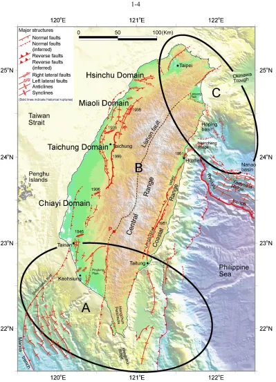
In the south, large anticlinal ridges and thrust faults deform the seafloors south of Taitung and Kaohsiung (Figure 1.1). These are expressions of the deformation and consumption of oceanic crust on both sides of the island’s southern peninsula. On the east side, oceanic crust of the forearc basin is clearly underthrusting beneath a major west-dipping thrust fault, which has long been known from both bathymetry and seismic profiles [e.g., Lundberg et al., 1997; Chang et al., 2001; Malavieille et al., 2002]. On the west side, two major left-lateral oblique thrust faults bound the rapidly subsiding Pingtung Plain. Between Tainan and Kaohsiung are several active N-S trending folds and NE-SW striking right-lateral faults. These onland structures accommodate E-W shortening and southward extrusion [e.g., Lacombe et al., 2001]. GPS geodesy across the two regions flanking the southern peninsula shows that each is shortening at about 40 mm/yr and that the western of the two is also extruding southward [Yu et al., 1997].
of translation are similar in the north and south.
Between Tainan and Taipei, along the western neotectonic belt, shallow marine rocks of the continental shelf are being thrust onto the outer shelf of the Taiwan Strait [e.g., Suppe and Namson, 1979; Suppe, 1987]. This shortening has four distinct manifestations, which lead us [Shyu et al., 2005a] to divide it into the Chiayi, Taichung, Miaoli, and Hsinchu Domains (Figure 1.1). Major blind thrust faults accommodate most of the shortening across the Chiayi and Miaoli Domains [Suppe, 1976; Suppe and Namson, 1979]. Several active folds are present in the hanging-wall blocks of these structures. In contrast, two major thrust faults dominate the Taichung Domain. Rupture of the eastern one, the Chelungpu fault, produced the 1999 Chi-Chi earthquake. Pre-1999 geodetic rates of strain across this domain were much smaller than rates to the south. A large earthquake in 1935 resulted from failure of a bending-moment backthrust within one of the synclines of the Miaoli Domain and a right-lateral accommodation structure between the Miaoli and Taichung Domains. Right-lateral accommodation structures on the edges of the Chiayi Domain produced large earthquakes in 1906 and 1946.
Active structures in the northern domains accommodate extension above the Ryukyu subduction zone (Figure 1.1). The Taipei Basin is a half-graben, bounded on the northwest by an active normal fault [Teng et al., 2001] that extends offshore as a minor fault on the continental shelf. This is consistent with GPS measurements, which show that the Taipei Basin is extending at low rates. Slip on this normal fault may have resulted in creation of a marine incursion into the basin in 1694 [Shieh, 2000].
South of the Ryukyu island arc are two submarine basins and a fold-and-thrust belt associated with the deformation front of the Ryukyu subduction zone (Figure 1.1). The Hoping basin is a triangular graben, bounded by normal faults on the west and south [Shyu et al., 2005a]. Bathymetry and historical seismicity indicate that right-lateral strike-slip faults traverse the basin. These help to accommodate the southward opening of the Okinawa Trough and the translation of the deformation front and Ryukyu island arc.
1.4 The Taiwan orogen as accreting and disarticulating twin sutures
Traditionally, the Taiwan orogen has been viewed by most as a classic example of active arc-continent collision, between the Luzon arc and the Eurasian continental margin [e.g., Barrier and Angelier, 1986; Suppe, 1987; Huang et al., 1997; Malavieille et al., 2002; and references therein]. In such views, the intervening Hengchun Ridge is simply the accretionary wedge at the leading edge of the Manila trench (Figure 1.2).
However, the lack of a structural break between the Hengchun Ridge, Hengchun Peninsula, and the Central Range and the presence of pre-Cenozoic continental basement in the Central Range of Taiwan [e.g., Ho, 1988] suggest that this strip may not be just a simple accretionary prism. This observation has inspired many alternative models for the Taiwan orogen [e.g., Hsu and Sibuet, 1995; Sibuet and Hsu, 1997; Wu et al., 1997;
Chemenda et al., 2001]. The pre-Cenozoic continental basement rocks in the Central Range led Lu and Hsü [1992] to suggest that the Central Range is a continental block, rifted away from southeastern China. Based on the structural continuity of the Central Range and the Hengchun Ridge, we think that they are, in fact, part of a thin sliver of continental lithosphere.
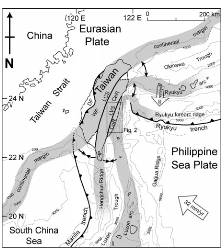
Figure 1.2. Taiwan is experiencing a tandem suturing of a volcanic arc and a sliver of continental crust to continental margin. In the south, the Luzon volcanic arc is converging on the Hengchun forearc ridge, which is, in turn, converging on the Chinese continental margin. Suturing of these three elements occurs in the middle of the island. In the north, both sutures are disarticulating, to form both the Okinawa Trough and troughs south of the Ryukyu island arc. Current velocity vector of the Philippine Sea plate is from [Yu et al., 1997, 1999]. Current velocity vector of the Ryukyu arc adapted from [Lallemand and Liu, 1998]. Both are relative to the Penghu Islands in the Taiwan Strait. Black dashed lines are the northern and western limits of the Wadati-Benioff zone of the two subducting systems taken from the seismicity database of the Central Weather Bureau, Taiwan. Bold lines indicate cross sections of Figure 1.3. DF: deformation front; LCS: Lishan-Chaochou suture; LVS: Longitudinal Valley suture; WF: Western Foothills; CeR: Central Range; CoR: Coastal Range; HP: Hengchun Peninsula; P: Outcrops of pillow lava along the western suture.
Figure 1.3. Three schematic crustal cross sections across Taiwan illustrate three stages in the process of tandem suturing and disengagement. A. Section just south of Taiwan shows the final stages of subduction and consumption of oceanic lithosphere between the three buoyant terranes. B. Section across central Taiwan shows relationship of the three terranes during suturing. C. Section north and east of Taiwan shows the subduction of the Philippine Sea plate and disengagement of the three terranes across the sutures. CHF: Changhua fault; CLPF: Chelungpu fault; LSF: Lishan fault; CRF: Central Range fault; LVF: Longitudinal Valley fault. No vertical exaggeration.
This hypothesis and the active structures of Taiwan lead us to propose that the Taiwan orogen is a twin suturing and parting of three lithospheric blocks. The Luzon volcanic arc and the Hengchun Ridge/Central Range/westernmost Ryukyu continental sliver join and separate along the eastern neotectonic belt. The western neotectonic belt results from the suturing and separation of this same continental sliver and the Eurasian continental margin (Figures 1.2 and 1.3).
lithospheric fragment. Many more observations than those mentioned above support this interpretation. The Hengchun Peninsula – an anticlinorial welt of deep marine rocks [Chen et al., 1985; Sung and Wang, 1985, 1986] that is rising at a rate of several mm/yr [Chen and Liu, 1993, 2000] – extends southward toward the Philippines as the elongate submarine Hengchun Ridge. Though covered by deep marine rocks, distinctive gravity signals and P-wave velocity suggest that the underlying rocks of the ridge may have continental affinity [e.g., Chi et al., 1998; Nakamura et al., 1998]. The Hengchun anticlinorium continues to the north as the Central Range, Taiwan’s mountainous backbone, where exhumation has been great enough to expose Paleozoic granites, marbles, and schists of the continental sliver [e.g., Ho, 1988]. Similar continental basement rocks may also exist beneath the marine rocks of the Hengchun anticlinorium, where the exhumation is just beginning. In the Central Range, the continental rocks are flanked by highly tectonized Cenozoic slates [e.g., Ho, 1988], which are likely the metamorphosed equivalent of the marine sedimentary cover of the Hengchun Peninsula and the Hengchun Ridge. Farther north, the similarity of basement rocks beneath the Ryukyu volcanoes to rocks of the Central Range [Kizaki, 1986] suggests the continuation of the continental sliver beneath the westernmost Ryukyu arc.
This continental sliver may have been split off the eastern margin of the Eurasian continent during the opening of the South China Sea, which occurred about 15 to 32 myr ago [e.g., Briais et al., 1993; Lee and Lawver, 1995]. Several other continental blocks within the South China Sea were, in fact, split off the Eurasian margin during this period [e.g., Lee and Lawver, 1994; Lin et al., 2003]. The recovery from wells of pre-Cenozoic rocks similar to the rocks of the Central Range at depths of several thousand meters beneath Taiwan’s west coast [Jahn et al., 1992] supports the idea that the Central Range is a sliver derived from the Asian continental margin.
side of the Hengchun Ridge, where oblique convergence between the Luzon volcanic arc and the Eurasian continental margin is occurring at about 80 mm/yr [Yu et al., 1999]. Half of this convergence occurs along the western belt, between the Hengchun Ridge and the continental margin, where oceanic lithosphere of the South China Sea is sliding eastward beneath the Hengchun Ridge continental sliver and the Philippine Sea plate (Figure 1.3a). Oceanic lithosphere is being consumed at a similar rate between the Hengchun Ridge and the Luzon volcanic arc. We propose that consumption of this oceanic lithosphere is being facilitated by westward underthrusting of the forearc basin, as suggested by clear bathymetric evidence [e.g., Malavieille et al., 2002; Shyu et al., 2005a]. Eastward subduction of forearc lithosphere beneath the Luzon arc has been proposed [e.g., Chemenda et al., 1997; Malavieille et al., 2002; Tang et al., 2002], but our analysis of bathymetry suggests that this is happening only locally [Shyu et al., 2005a].
Consumption of the oceanic fragments west and east of the Hengchun Peninsula is nearing completion at about 23°N, the northern limit of the Wadati-Benioff zone [Kao et al., 2000] (dashed line in Figure 1.2). The presence of the subducting slab beneath the Pingtung Plain suggests that the rapid subsidence of the plain is related to foundering of subjacent oceanic lithosphere. The termination of the active faults bounding the Pingtung Plain at its northern end also suggests that subduction ends and collision begins at that latitude.
Consumption of forearc oceanic crust between the Hengchun Peninsula and the Luzon volcanic arc ends near Taitung, where the thrust faults and folds on the ocean floor disappear (Figure 1.1). Ultramafic blocks in the Lichi Formation along the southwestern margin of the Coastal Range [e.g., Ho, 1988] are likely the remnants of this forearc oceanic lithosphere [e.g., Chang et al., 2001].
extremely obvious topographically and constitutes a major boundary between two very different sedimentary facies of Eocene-Miocene slate on either side of the fault: The slates west of the fault originated in shallow shelf to coastal environments, whereas the slates east of the fault, in the Central Range, formed in a much deeper basin [e.g., Ho, 1988]. Near the southern end of this structure, Early Miocene(?) pillow lavas that crop out along our proposed western suture [Kuo, 1984] (P in Figures 1.1 and 1.2) may well be a remnant of South China Sea oceanic crust.
The accretion of the continental sliver to the continental margin created a myriad of active structures in the fold-and-thrust belt of western Taiwan. Both the characteristics of the active structures and geodetically determined rates of shortening indicate that the accretion matures northward [e.g., Yu et al., 1997]. These thin-skinned structures developed in the deformed sedimentary wedge above and west of the lithospheric suture, and the eastern boundary of the wedge is the Lishan fault (Figure 1.3b). This relationship of the thrusts to the Lishan fault would indicate that the western neotectonic belt of Taiwan has both a thick-skinned and a thin-skinned manifestation. The active faults of the Western Foothills are thin-skinned, but they root into a lithospheric suture.
neotectonic belt, the degree of development of the structures and lessening of geodetic rates of convergence [e.g., Yu et al., 1997] indicate that suturing matures northward.
Both sutures are disarticulating across northeastern Taiwan. Along the western suture, the continental sliver begins to tear away from the Asian continental margin in the Lanyang Plain, which is bounded by normal faults (Figure 1.1). The fact that the apex of the triangle-shaped plain is at the northern end of the Lishan fault indicates clearly that the parting is occurring along the old suture. The plain widens to the east into the westernmost part of the Okinawa Trough (Figures 1.2 and 1.3c).
It is noteworthy that the current arc volcanism in western Ryukyu is localized between the northern part of the Ryukyu arc and the center of the Okinawa Trough [e.g.,
Sibuet et al., 1998; Chung et al., 2000] (Figure 1.3c). Thus, the Okinawa Trough is not a conventional back-arc basin. Instead, its spreading may be better explained by the post-collisional disengagement of the continental sliver from the Asian continental margin [e.g., Teng, 1996; Wang et al., 1999; Chung et al., 2000].
In summary, the sliver approaches the continental margin in southern Taiwan, accretes to it in central Taiwan, and disengages from the continental margin across the Lanyang Plain in northeastern Taiwan. Normal faulting that created the Taipei Basin is therefore a minor manifestation of the disarticulation of the western suture, off on the western edge of the Western Foothills.
of the Coastal Range disarticulates from the Central Range along the northeastern coast (Figures 1.2 and 1.3c). Normal faults and complex strike-slip faults surrounding the Hoping basin (Figure 1.1) would represent the initiation of this disengagement.
The accretion of pieces of continent and volcanic island arcs onto continental margins is one of the most common phenomena in the geologic record [e.g., Saleeby, 1983; Şengör and Natal’in, 1996]. The disarticulation of lithosphere in areas of former suture zones may also be commonplace in Earth’s geologic history (e.g., the Aegean Sea). Taiwan is, however, one of the very few places on Earth that exhibit both phenomena in action in a single orogenic belt; suturing that begins in the south is coming undone in the north and east (Figures 1.2 and 1.3). This occurs in tandem, with a separate suture on each side of a narrow sliver of continental material that is caught between the volcanic arc and the continent.
In this example, it is clear that the disengagement of terranes occurs along the not-so-old sutures. This may well reflect a fundamental weakness in the lithospheric sutures. In this case, it appears that all that is needed to induce disengagement of the terranes is the subduction of the Philippine Sea plate along the Ryukyu subduction zone to a position below the upper crust. Once this buttress is removed, the two sutures disengage.
1.5 Implications for future earthquake sources
aseismically?
Large thrust faults in the submarine realm south of Taitung may also generate large subduction-like earthquakes. High rates of suturing along the southern Longitudinal Valley should mean that large earthquakes are more common there than in the northern Longitudinal Valley, as has been the case during the century or so of recorded history.
One can reasonably expect the blind thrust faults of the western neotectonic belt (in the Chiayi and Miaoli Domains) to generate earthquakes at least as large as that generated in 1999 by the intervening Chelungpu thrust. The normal fault on the western side of the Taipei Basin half-graben should generate earthquakes less frequently than normal faults near the Lanyang Plain because strain rates are so much lower across the Taipei Basin. One can expect the western margin of the Ryukyu subduction zone to generate a bewildering variety of large earthquakes given the abundance of right-lateral tear faults and normal faults there.
Finally, rapid uplift of the Central Range may not imply loading of seismic sources within the Central Range lithosphere. Instead, pervasive ductile crustal thickening may produce the rapid uplift.
1.6 Concluding Remarks
The construction of this tandem-suture model of the Taiwan orogen was made possible by our comprehensive mapping of the neotectonic elements of Taiwan. Our descriptions of active structures, in combination with previously published structural, stratigraphic, and geophysical information necessitated a new tectonic framework for the orogen. This new tectonic framework involves three lithospheric elements, two continental and one island-arc, which first suture and then disengage.
1.7 Acknowledgments
1.8 References
Barrier, E., and J. Angelier (1986), Active collision in eastern Taiwan: the Coastal Range,
Mem. Geol. Soc. China, 7, 135-159.
Bonilla, M. G. (1975), A review of recently active faults in Taiwan, Open File Rep. 75-41, 58pp., U. S. Geol. Surv., Menlo Park, Calif.
Bonilla, M. G. (1977), Summary of Quaternary faulting and elevation changes in Taiwan,
Mem. Geol. Soc. China, 2, 43-55.
Briais, A., P. Patriat, and P. Tapponnier (1993), Updated interpretation of magnetic anomalies and seafloor spreading stages in the South China Sea: implications for the Tertiary tectonics of Southeast Asia, J. Geophys. Res., 98, 6,299-6,328.
Chang, C. P., J. Angelier, C. Y. Huang, and C. S. Liu (2001), Structural evolution and significance of a mélange in a collision belt: the Lichi Mélange and the Taiwan arc-continent collision, Geol. Mag., 138, 633-651.
Chemenda, A. I., R. K. Yang, C.-H. Hsieh, and A. L. Groholsky (1997), Evolutionary model for the Taiwan collision based on physical modelling, Tectonophysics, 274, 253-274.
Chemenda, A. I., R.-K. Yang, J.-F. Stephan, E. A. Konstantinovskaya, and G. M. Ivanov (2001), New results from physical modelling of arc-continent collision in Taiwan: evolutionary model, Tectonophysics, 333, 159-178.
Chen, H.-H., and R.-J. Rau (2002), Earthquake locations and style of faulting in an active arc-continent plate boundary: the Chihshang fault of eastern Taiwan, EOS, Trans., Am. Geophys. Uni., 83(47), Fall Meet. Suppl., Abstract T61B-1277.
Chen, W.-S. (1988), Tectonic evolution of sedimentary basins in Coastal Range, Taiwan (in Chinese), Ph.D. thesis, 304pp., Natl. Taiwan Univ., Taipei.
Chen, W.-S., Y.-M. Cheng, and C.-Y. Huang (1985), Geology of the Hengchun Peninsula, southern Taiwan (in Chinese with English abstract), Ti-Chih, 6(2), 47-74.
Chen, Y.-G., and T.-K. Liu (1993), Holocene radiocarbon dates in Hengchun Peninsula and their neotectonic implications, J. Geol. Soc. China, 36, 457-479.
Chen, Y.-G., and T.-K. Liu (2000), Holocene uplift and subsidence along an active tectonic margin southwestern Taiwan, Quat. Sci. Rev., 19, 923-930.
Chen, Y.-G., W.-S. Chen, J.-C. Lee, Y.-H. Lee, C.-T. Lee, H.-C. Chang, and C.-H. Lo (2001), Surface rupture of 1999 Chi-Chi earthquake yields insights on active tectonics of central Taiwan, Bull. Seismol. Soc. Am., 91, 977-985.
1988 (in Chinese), 255pp., Inst. Earth Sci., Acad. Sinica, Taipei, Taiwan.
Chi, W.-C., D. L. Reed, C.-S. Liu, and N. Lundberg (1998), Distribution of the bottom-simulating reflector in the offshore Taiwan collision zone, Terr. Atmos. Oceanic Sci., 9, 779-794.
Chung, S.-L., S.-L. Wang, R. Shinjo, C.-S. Lee, and C.-H. Chen (2000), Initiation of arc magmatism in an embryonic continental rifting zone of the southernmost part of Okinawa Trough, Terra Nova, 12, 225-230.
Ho, C. S. (1986), A synthesis of the geologic evolution of Taiwan, Tectonophysics, 125, 1-16.
Ho, C. S. (1988), An Introduction to the Geology of Taiwan, Explanatory Text of the Geologic Map of Taiwan, 2nd ed., 192pp., Cent. Geol. Surv., Ministry Econ. Affairs, Taipei, Taiwan.
Hovius, N., C. P. Stark, H.-T. Chu, and J.-C. Lin (2000), Supply and removal of sediment in a landslide-dominated mountain belt: Central Range, Taiwan, J. Geol., 108, 73-89. Hsu, M.-T. (1980), Earthquake Catalogues in Taiwan (from 1644 to 1979) (in Chinese),
77pp., Natl. Taiwan Univ., Taipei.
Hsu, S.-K., and J.-C. Sibuet (1995), Is Taiwan the result of arc-continent or arc-arc collision?, Earth Planet. Sci. Lett., 136, 315-324.
Huang, C.-Y., C.-T. Shyu, S. B. Lin, T.-Q. Lee, and D. D. Sheu (1992), Marine geology in the arc-continent collision zone off southeastern Taiwan: Implications for Late Neogene evolution of the Coastal Range, Mar. Geol., 107, 183-212.
Huang, C.-Y., W.-Y. Wu, C.-P. Chang, S. Tsao, P. B. Yuan, C.-W. Lin, and K.-Y. Xia (1997), Tectonic evolution of accretionary prism in the arc-continent collision terrane of Taiwan, Tectonophysics, 281, 31-51.
Jahn, B.-M., W.-R. Chi, and T.-F. Yui (1992), A late Permian formation of Taiwan (marbles from Chia-Li Well No.1): Pb-Pb isochron and Sr isotopic evidence, and its regional geological significance, J. Geol. Soc. China, 35, 193-218.
Ji, C., D. V. Helmberger, T.-R. A. Song, K.-F. Ma, and D. J. Wald (2001), Slip distribution and tectonic implication of the 1999 Chi-Chi, Taiwan, Earthquake, Geophys. Res. Lett.,
28, 4,379-4,382.
Johnson, K. M., Y.-J. Hsu, P. Segall, and S.-B. Yu (2001), Fault geometry and slip distribution of the 1999 Chi-Chi, Taiwan earthquake imaged from inversion of GPS data, Geophys. Res. Lett., 28, 2,285-2,288.
Kelson, K. I., K.-H. Kang, W. D. Page, C.-T. Lee, and L. S. Cluff (2001), Representative styles of deformation along the Chelungpu fault from the 1999 Chi-Chi (Taiwan) earthquake: Geomorphic characteristics and responses of man-made structures, Bull. Seismol. Soc. Am., 91, 930-952.
Kizaki K. (1986), Geology and tectonic framework of the Ryukyu Islands, Mem. Geol. Soc. China, 7, 1-14.
Kuo, C.-S. (1984), Geochemistry and isotopic analysis of spilite in the Paolai area (in Chinese), M.S. thesis, 96pp., Natl. Taiwan Univ., Taipei.
Lacombe, O., F. Mouthereau, J. Angelier, and B. Deffontaines (2001), Structural, geodetic and seismological evidence for tectonic escape in SW Taiwan, Tectonophysics,
333, 323-345.
Lallemand, S., and C.-S. Liu (1998), Geodynamic implications of present-day kinematics in the southern Ryukyus, J. Geol. Soc. China, 41, 551-564.
Lee, T.-Y., and L. A. Lawver (1994), Cenozoic plate reconstruction of the South China Sea region, Tectonophysics, 235, 149-180.
Lee, T.-Y., and L. A. Lawver (1995), Cenozoic plate reconstruction of Southeast Asia,
Tectonophysics, 251, 85-138.
Lin, A. T., A. B. Watts, and S. P. Hesselbo (2003), Cenozoic stratigraphy and subsidence history of the South China Sea margin in the Taiwan region, Basin Res., 15, 453-478. Lu, C.-Y., and K. J. Hsü (1992), Tectonic evolution of the Taiwan mountain belt, Pet.
Geol. Taiwan, 27, 21-46.
Lundberg, N., D. L. Reed, C.-S. Liu, and J. Lieske, Jr. (1997), Forearc-basin closure and arc accretion in the submarine suture zone south of Taiwan, Tectonophysics, 274, 5-23. Ma, K.-F., T.-R. A. Song, S.-J. Lee, and H.-I. Wu (2000), Spatial slip distribution of the
September 20, 1999, Chi-Chi, Taiwan, earthquake (Mw7.6)—Inverted from teleseismic data, Geophys. Res. Lett., 27, 3,417-3,420.
Ma, K.-F., J. Mori, S.-J. Lee, and S. B. Yu (2001), Spatial and temporal distribution of slip for the 1999 Chi-Chi, Taiwan, earthquake, Bull. Seismol. Soc. Am., 91, 1,069-1,087.
Malavieille, J., S. E. Lallemand, S. Dominguez, A. Deschamps, C.-Y. Lu, C.-S. Liu, P. Schnürle, and the ACT Scientific Crew (2002), Arc-continent collision in Taiwan: new marine observations and tectonic evolution, Geol. Soc. Am. Spec. Paper, 358, 187-211. Nakamura, Y., K. McIntosh, and A. T. Chen (1998), Preliminary results of a large offset
seismic survey west of Hengchun Peninsula, southern Taiwan, Terr. Atmos. Oceanic Sci., 9, 395-408.
Earth Planet. Sci., 15, 45-73.
Şengör, A. M. C., and B. A. Natal’in (1996), Paleotectonics of Asia: fragments of a synthesis, in The Tectonic Evolution of Asia, edited by A. Yin, and M. Harrison, pp. 486-640, Cambridge Univ. Press, Cambridge, UK.
Shieh, Y.-T. (2000), The paleogeography of the ancient Taipei lakebed in the K’anghsi Period (in Chinese with English abstract), J. Geogr. Sci., 27, 85-95.
Shyu, J. B. H., K. Sieh, Y.-G. Chen, and C.-S. Liu (2005a), The neotectonic architecture of Taiwan and its implications for future large earthquakes, J. Geophys. Res., 110, B08402, doi:10.1029/2004JB003251.
Shyu, J. B. H., L.-H. Chung, Y.-G. Chen, J.-C. Lee, and K. Sieh (2005b), Re-evaluation of the surface ruptures of the November 1951 earthquake series in eastern Taiwan, and its neotectonic implications, J. Asian Earth Sci., submitted for publication.
Sibuet, J.-C., and S.-K. Hsu (1997), Geodynamics of the Taiwan arc-arc collision,
Tectonophysics, 274, 221-251.
Sibuet, J.-C., B. Deffontaines, S.-K. Hsu, N. Thareau, J.-P. Le Formal, C.-S. Liu, and ACT party (1998), Okinawa trough backarc basin: Early tectonic and magmatic evolution, J. Geophys. Res., 103, 30,245-30,267.
Sung, Q.-C., and Y. Wang (1985), Petrofacies of Miocene sediments in the Hengchun Peninsula and its tectonic implication, Proc. Geol. Soc. China, 28, 23-44.
Sung, Q., and Y. Wang (1986), Sedimentary environments of the Miocene sediments in the Hengchun Peninsula and their tectonic implication, Mem. Geol. Soc. China, 7, 325-340.
Suppe, J. (1976), Décollement folding in southwestern Taiwan, Pet. Geol. Taiwan, 13, 25-35.
Suppe, J. (1984), Kinematics of arc-continent collision, flipping of subduction, and back-arc spreading near Taiwan, Mem. Geol. Soc. China, 6, 21-33.
Suppe, J. (1987), The active Taiwan mountain belt, in Anatomy of Mountain Chains, edited by J. P. Schaer, and J. Rodgers, pp. 277-293, Princeton Univ. Press, Princeton, N.J.
Suppe, J., and J. Namson (1979), Fault-bend origin of frontal folds of the western Taiwan fold-and-thrust belt, Pet. Geol. Taiwan, 16, 1-18.
Tan, L. P. (1977), Pleistocene eastward bending of the Taiwan arc, Mem. Geol. Soc. China, 2, 77-83.
Teng, L. S. (1987), Stratigraphic records of the late Cenozoic Penglai orogeny of Taiwan,
Acta Geol. Taiwanica, 25, 205-224.
Teng, L. S. (1990), Late Cenozoic arc-continent collision in Taiwan, Tectonophysics, 183, 57-76.
Teng, L. S. (1996), Extensional collapse of the northern Taiwan mountain belt, Geology,
24, 949-952.
Teng, L. S., C. T. Lee, C.-H. Peng, W.-F. Chen, and C.-J. Chu (2001), Origin and geological evolution of the Taipei Basin, northern Taiwan, Western Pacific Earth Sci.,
1, 115-142.
Wang, K.-L., S.-L. Chung, C.-H. Chen, R. Shinjo, T. F. Yang, and C.-H. Chen (1999), Post-collisional magmatism around northern Taiwan and its relation with opening of the Okinawa Trough, Tectonophysics, 308, 363-376.
Wu, F. T., R.-J. Rau, and D. Salzberg (1997), Taiwan orogeny: thin-skinned or lithospheric collision?, Tectonophysics, 274, 191-220.
Yu, S.-B., H.-Y. Chen, and L.-C. Kuo (1997), Velocity field of GPS stations in the Taiwan area, Tectonophysics, 274, 41-59.
Chapter 2
Neotectonic Architecture of Taiwan and Its Implications for Future
Large Earthquakes
An edited version of this chapter has been published as:
2.1 Abstract
The disastrous effects of the 1999 Chi-Chi earthquake in Taiwan demonstrated an urgent need for better knowledge of the island’s potential earthquake sources. Toward this end, we have prepared a neotectonic map of Taiwan. The map and related cross sections are based upon structural and geomorphic expression of active faults and folds both in the field and on shaded-relief maps prepared from a 40-m resolution digital elevation model, augmented by geodetic and seismologic data. The active tandem suturing and tandem disengagement of a volcanic arc and a continental sliver to and from the Eurasian continental margin have created two neotectonic belts in Taiwan. In the southern part of the orogen, both belts are in the final stage of consuming oceanic crust. Collision and suturing occur in the middle part of both belts, and post-collisional collapse and extension dominate the island’s northern and northeastern flanks. Both belts consist of several distinct neotectonic domains. Seven domains – Kaoping, Chiayi, Taichung, Miaoli, Hsinchu, Ilan, and Taipei – constitute the western belt, and four domains – Lutao-Lanyu, Taitung, Hualien, and Ryukyu – make up the eastern belt. Each domain is defined by a distinct suite of active structures. For example, the Chelungpu fault (source of the 1999 earthquake) and its western neighbor, the Changhua fault, are the principal components of the Taichung Domain, whereas both its neighboring domains – the Chiayi and Miaoli Domains – are dominated by major blind faults. In most of the domains, the size of the principal active fault is large enough to produce future earthquakes with magnitudes in the mid-7 values.
2.2 Introduction
Throughout its brief recorded history, Taiwan has experienced many strong and destructive earthquakes [e.g., Bonilla, 1975, 1977; Hsu, 1980; Cheng and Yeh, 1989]. These are the seismic manifestation of several million years of orogeny [e.g., Ho, 1986;
Teng, 1987, 1990, 1996] (Figure 2.1). The human response to high seismicity has been building codes that anticipate high probabilities of future strong shaking on the island. Nonetheless, the disastrous effects of the Mw 7.6 Chi-Chi earthquake of 1999 show that
many damaging effects were not anticipated. Meters of slip on the Chelungpu fault generated remarkable scarps that sliced through more than 80 km of urban, agricultural, and fluvial landscapes [Central Geological Survey, 1999a, 1999b; Chen et al., 2002]. Folding produced impressive broad deformation of the ground surface and resultant large areas of damage [Chen et al., 2001; Kelson et al., 2001; Lee et al., 2002]. Modeling of geodetic and seismic data showed that the specific geometries of the fault surfaces played an important role in the production of the patterns, durations, and levels of seismic shaking and surface deformation [Ma et al., 2000, 2001; Ji et al., 2001].
Many of these co-seismic phenomena could have been anticipated accurately if the earthquake source had been known in advance of the earthquake. For example, the trace of the principal fault that produced the 1999 earthquake was clear from its geomorphic expression well before its 1999 rupture, but had not been used to map prior ruptures systematically [Chen et al., 2002]. The basic subsurface geometry of the fault had been known for nearly two decades [e.g., Suppe, 1976, 1980a, 1980b], but important details had not been investigated using the patterns of deformation of fluvial terraces along the fault. The same is true of several other destructive historical co-seismic ruptures in Taiwan, most notably those of 1935 and 1951. This demonstrates the practical need for better knowledge of the active structures of the island.
Figure 2.1. A neotectonic snapshot of Taiwan and adjacent regions. (a) Taiwan is currently experiencing a double suturing: In the south, the Luzon volcanic arc is colliding with the Hengchun forearc ridge, which is, in turn, colliding with the Eurasian continental margin. In the north, both sutures are unstitching. Their disengagement is forming both the Okinawa Trough and the forearc basins of the Ryukyu arc. Thus, in the course of passing through the island, the roles of the volcanic arc and forearc ridge flip along with the flipping of the polarity of subduction. The three gray strips represent the three lithospheric pieces of Taiwan’s tandem suturing and disarticulation: the Eurasian continental margin, the continental sliver, and the Luzon arc. Black arrows indicate the suturing and disarticulation. This concept is discussed in detail in Shyu et al. [2005a]. Current velocity vector of the Philippine Sea plate relative to the Eurasian plate adapted from Yu et al. [1997, 1999]. Current velocity vector of the Ryukyu arc adapted from Lallemand and Liu [1998]. Black dashed lines are the northern and western limits of the Wadati-Benioff zone of the two subducting systems, taken from the seismicity database of the Central Weather Bureau, Taiwan. DF: deformation front; LCS: Lishan-Chaochou suture; LVS: Longitudinal Valley suture; WF: Western Foothills; CeR: Central Range; CoR: Coastal Range; HP: Hengchun Peninsula. (b) Major tectonic elements around Taiwan. Active structures identified in this study are shown in red. Major inactive faults that form the boundaries of tectonic elements are shown in black: 1: Chiuchih fault; 2: Lishan fault; 3: Laonung fault; 4: Chukou fault. Selected GPS vectors relative to the stable Eurasian continental shelf adapted from Yu et al.
[1997]. A: Western Foothills; B: Hsueshan Range; C: Central Range and Hengchun Peninsula; D: Coastal Range; E: westernmost Ryukyu arc; F: Yaeyama forearc ridge; G: northernmost Luzon arc; H: western Taiwan coastal plains; I: Lanyang Plain; J: Pingtung Plain; K: Longitudinal Valley; L: submarine Hengchun Ridge; M: Ryukyu forearc basins.
piece of the puzzle because so much of the older record has been eroded or buried [Gilbert, 1890, p.1]. On the more practical side, those interested in forecasting the effects of future fault ruptures must understand the locations, forms, and sense of slip of the active faults of the island. Realistic estimates of the magnitudes and patterns of future seismic shaking also require such knowledge. Moreover, reasonable interpretations of deformations now being recorded by an extensive geodetic network will be made best in the context of a firm structural, stratigraphic, and geomorphologic framework. And, finally, future land-use planning will be well served by maps of geologically recent surface faulting and folding in combination with maps of other geologic hazards.
Taiwan is well poised for the synoptic neotectonic evaluation we describe below. For decades, geographers have been mapping deformed fluvial and marine coastal terraces. More recently, radiometric dating of some of these surfaces has enabled determination of rates of the latest Pleistocene and Holocene deformation. Concurrent with these geomorphic efforts, stratigraphers and structural geologists have been mapping the surface and subsurface configurations of young sediments, faults, and folds, and employing these to interpret the Neogene history of the Taiwan orogen. For the most part, however, these geomorphologic, stratigraphic and structural studies have not been applied to interpreting the youngest active structures of the island, nor have they been systematically integrated into a synoptic neotectonic map.
At the other extreme are maps that depict as active only those faults that have ruptured historically [e.g., H.-C. Chang et al., 1998; Lin et al., 2000a]. These clearly are shutting the door after the horse has run out of the barn.
Our principal means for mapping the active structures of the island has been the use of fluvial and coastal landforms, which cover more than half of the surface of the island. Uplift and deformation of these features are readily apparent on shaded-relief maps. In many places we have also utilized more detailed mapping of landforms published by others.
The recent availability of a high-resolution national digital elevation model (DEM) makes the creation of a neotectonic map from landforms far easier than it would have been just a few years ago. Made from aerial photography of the island, the DEM has an elevation posting every 40 m. Although standard stereographic aerial photographs have higher resolution and include tonal information, they are not geo-referenced, so the data derived therefrom are more difficult to compile and view. The 40-m DEM displays all major and most minor topographic features necessary for interpreting broadly the tectonic geomorphology of the island. Furthermore, high-resolution bathymetric databases that have recently become available [e.g., Lallemand et al., 1997; Liu et al., 1998; Malavieille et al., 2002] allow us to incorporate geomorphic information from the surrounding sea floor.
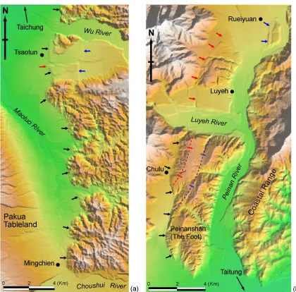
Figure 2.2. Two examples showing the geomorphic evidence for active structures visible in the 40-m DEM. Figures of similar resolution for other parts of Taiwan are available as electronic data supplements. Locations of the two are shown in Figure 2.1(b). (a) Along a southern segment of the Chelungpu fault, topographic features not only readily predict the locations of the 1999 major rupture (marked by black arrows), but also show a minor, secondary fault rupture (marked by a red arrow) and a monoclinal surface rupture on the hanging wall of the fault (marked by blue arrows). (b) Near the southern end of the Longitudinal Valley, eastern Taiwan, geomorphic features clearly show a thrust fault along the western edge of the Peinanshan (marked by black arrows). The same fault becomes a series of anticlinal folds north of the Luyeh River (marked by red arrows) and eventually steps eastward to the western base of the river terraces east of Rueiyuan (marked by blue arrows). Fluvial surfaces in northern part of the Peinanshan clearly warped into an anticline (in red) and a syncline (in blue).
Our primary reliance on the geomorphic manifestation of active structures means, of course, that we have undoubtedly missed some important features. For example, in the coastal plains where sedimentation rates are as high as 20 mm/yr [e.g., Shyu, 1999], surfaces that are deforming slowly may well be buried beneath late Holocene deposits. We have attempted to minimize this deficiency by incorporating locally available subsurface data. We may also have neglected to identify faults with low rates of slip within the high mountains, where rates of erosion are more than 5 mm/yr [e.g., Hovius et al., 2000]. Furthermore, small features, such as the scarps that formed on the coastal plain during the historical earthquakes of 1906, 1935 and 1946, have been obliterated by human activity. We have relied on published post-seismic investigations of these historical ruptures to ensure that our map is as complete as possible. But this, of course, means that we are likely to have missed similar structures on the coastal plains that ruptured prior to the 20th century.
We have augmented our geomorphic analysis with as much additional stratigraphic and structural data as was available to us to construct our map of the active tectonic features of the island. Even so, we do not claim to have made a complete description of the active structures of Taiwan. Decades of additional work would be required to accomplish that goal. Our intent has been simply to provide an up-to-date picture of the active neotectonic features of the island, compiled from sources of data currently available, and their implications for future large earthquakes.
2.3 Neotectonic overview of Taiwan
(Figure 2.1a). To the north, by contrast, the polarity of subduction is the opposite, and extension is occurring at about 30-40 mm/yr in a back-arc region above the Ryukyu subduction zone [e.g., Lallemand and Liu, 1998].
The active Taiwan orogen embodies a tandem suturing and disarticulation [Shyu et al., 2005a]. In southernmost Taiwan, consumption of the Eurasian oceanic lithosphere is nearly complete, and two collisions are beginning (Figure 2.1a). On the west is the collision of a forearc sliver embedded within the Philippine Sea plate and the Eurasian continental margin. On the east is the collision of the forearc sliver and the Luzon volcanic arc [e.g., Biq, 1972; Barrier and Angelier, 1986; Suppe, 1987; Reed et al., 1992;
Lundberg et al., 1992; Huang et al., 1992, 1997; Malavieille et al., 2002]. Taiwan consists of the rocks of these three lithospheric elements. Clastic sedimentary rocks of the shallow marine continental shelf constitute the western half of the island. Basement rocks and deep marine sedimentary rocks of the forearc ridge form the island’s high mountainous backbone. And volcanic rocks and associated marine sedimentary rocks underlie the central eastern coast.
The Taiwan orogen is collapsing in the north and east because of its transfer to the region of back-arc extension of the Ryukyu subduction zone [Teng, 1996; Teng et al., 2000] (Figure 2.1a). The predominant feature of this back-arc region is the gaping Okinawa Trough, which has been opening to the south along the eastern flank of the island for the past few million years [e.g., Suppe, 1987; Teng, 1996]. This collapse in the north is chasing construction of the fold-and-thrust belt in the south and center.
The collapse of the orogen in the north is concentrated along the two sutures. The western suture is unstitching across the Okinawa Trough, which can be considered a reincarnation of the South China Sea. The eastern suture is tearing apart along the coastline a little farther south [Shyu et al., 2005a] (Figure 2.1a). The disengagement of the western suture is clearly manifest in the oroclinal bending of the rocks of Taiwan’s Central Range at the southern limit of current extension, where foliations of Central Range rocks bend eastward and strike out to sea, toward the Ryukyu island arc [e.g., Tan, 1977; Suppe, 1984]. Except for a right-lateral tear, no major structural break appears between the rocks of Taiwan’s mountainous backbone and the westernmost part of the Ryukyu island arc. In fact, the oldest rocks of the southern Ryukyu Islands are metamorphic rocks that are similar to the Tananao Schists of the Central Range of Taiwan [e.g., Kizaki, 1986]. Thus, the Ryukyu arc next to Taiwan may well be the ancient forearc ridge of the Philippine Sea plate.
A similar disengagement of the eastern suture is apparent farther south, where the rocks of the Luzon arc in Taiwan’s Coastal Range are pulling away from those of the forearc ridge (Central Range). Although we have no knowledge of the properties of the basement rocks between the Ryukyu arc and the trench, topography suggests that the old Luzon arc lithosphere overlies the more shallow parts of the Ryukyu subduction zone [Shyu et al., 2005a].
2.4 Neotectonic domains of Taiwan
The Taiwan orogen consists of two principal loci of active deformation (Figures 2.1 and 2.3). On the west is a fold-and-thrust belt, along which shallow marine rocks of the outer continental shelf are piling up onto the Eurasian continental shelf of the Taiwan Strait. On the east is a second collisional belt, where the Luzon volcanic arc of the Philippine Sea plate is slamming into forearc rocks of the Central Range. Along both the eastern and western systems, collision began in the north about 5 myr ago [Ho, 1986;
Suppe, 1987; Teng, 1987, 1990], reached the middle of the island about 3 myr ago [Teng, 1987, 1990], and is just beginning near Taiwan’s southern tip [Huang et al., 1992, 1997, 2000; Kao et al., 2000]. In the process of double collision, most of the 300-km-wide piece of oceanic lithosphere between the Manila trench and the Luzon volcanic island arc has disappeared. Only the 40-km-wide strip of forearc-ridge lithosphere remains as the backbone of the island. The result has been a southward-progressing orogen.
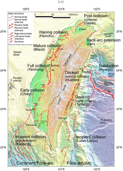
Our examination reveals that the manifestation of active deformation varies considerably and progressively from south to north. However, this progressive along-strike variation in deformation is not gradational. Instead, it occurs across discrete steps. Hence, both the western and the eastern belts divide naturally into several distinct structural domains. Seven discrete domains comprise the western belt, and four constitute the eastern belt. Distinct principal structures characterize each of these eleven domains. Some domains are dominated by relatively simple emergent thrust faults, whereas others are dominated by hidden, or “blind,” thrusts. In some domains the principal structures traverse tens of kilometers and cross the entire domain. In other cases, a myriad of small active structures prevail. The transitions between domains are well defined, although in several cases they are 10 to 20 km wide and involve the interpenetration of principal structures from the adjacent domains.
neotectonic belts. In each section we discuss the general characteristics of each of the eleven active structure domains. Each domain derives its name from the most prominent city or other geographic feature of the region. Due to space limitations, we have made more detailed discussion of these neotectonic domains, together with higher-resolution interpreted DEM figures, available as electronic data supplements.
2.4.1 Eastern neotectonic belt
The progressive south-to-north accretion and disengagement of the volcanic arc occurs across four discrete domains in eastern Taiwan. From south to north, collision is proceeding from the Lutao-Lanyu to the Taitung and Hualien Domains (Figure 2.3). These correspond to three stages in the accretion of the island arc—incipient collision, docking, and docked. Farther east and north, the Ryukyu Domain encompasses the splitting of the Coastal Range away from the Central Range and the locked part of the Ryukyu subduction interface.
suggest that accretion is nearing completion. Just north of the Hualien Domain, in the transition to the subduction of the Ryukyu Domain, the volcanic arc and f