www.the-cryosphere.net/10/1003/2016/ doi:10.5194/tc-10-1003-2016
© Author(s) 2016. CC Attribution 3.0 License.
Past ice-sheet behaviour: retreat scenarios and changing controls in
the Ross Sea, Antarctica
Anna Ruth W. Halberstadt1, Lauren M. Simkins1, Sarah L. Greenwood2, and John B. Anderson1 1Department of Earth Science, Rice University, Houston, Texas 77005, USA
2Department of Geological Sciences, Stockholm University, 10691 Stockholm, Sweden
Correspondence to: Anna Ruth W. Halberstadt (ar.halberstadt@rice.edu)
Received: 3 February 2016 – Published in The Cryosphere Discuss.: 10 February 2016 Revised: 26 April 2016 – Accepted: 29 April 2016 – Published: 13 May 2016
Abstract. Studying the history of ice-sheet behaviour in the Ross Sea, Antarctica’s largest drainage basin can im-prove our understanding of patterns and controls on marine-based ice-sheet dynamics and provide constraints for numer-ical ice-sheet models. Newly collected high-resolution multi-beam bathymetry data, combined with two decades of legacy multibeam and seismic data, are used to map glacial land-forms and reconstruct palaeo ice-sheet drainage.
During the Last Glacial Maximum, grounded ice reached the continental shelf edge in the eastern but not western Ross Sea. Recessional geomorphic features in the western Ross Sea indicate virtually continuous back-stepping of the ice-sheet grounding line. In the eastern Ross Sea, well-preserved linear features and a lack of small-scale recessional land-forms signify rapid lift-off of grounded ice from the bed. Physiography exerted a first-order control on regional ice be-haviour, while sea floor geology played an important sub-sidiary role.
Previously published deglacial scenarios for Ross Sea are based on low-spatial-resolution marine data or terrestrial ob-servations; however, this study uses high-resolution basin-wide geomorphology to constrain grounding-line retreat on the continental shelf. Our analysis of retreat patterns sug-gests that (1) retreat from the western Ross Sea was complex due to strong physiographic controls on ice-sheet drainage; (2) retreat was asynchronous across the Ross Sea and be-tween troughs; (3) the eastern Ross Sea largely deglaciated prior to the western Ross Sea following the formation of a large grounding-line embayment over Whales Deep; and (4) our glacial geomorphic reconstruction converges with recent numerical models that call for significant and complex East
Antarctic ice sheet and West Antarctic ice sheet contributions to the ice flow in the Ross Sea.
1 Introduction
The Ross Embayment drains ∼25 % of the Antarctic ice sheet into the Ross Sea and is thus the largest ice drainage basin in Antarctica, fed by multiple ice streams sourced from the East Antarctic (EAIS) and West Antarctic (WAIS) ice sheets (Fig. 1). The nature of ice-sheet palaeodrainage and retreat in the Ross Sea has significant implications for un-derstanding the dynamics of the WAIS and EAIS, and their respective sensitivities to factors that govern ice behaviour. These insights may also aid understanding of ice dynam-ics in the other large embayments around Antarctica, such as the Weddell Sea and Amundsen Sea embayments, where large uncertainty in palaeo-ice extent and grounding-line re-treat remains (Bentley et al., 2014). Recent ice-sheet mod-els indicate complex ice behaviour in the Ross Sea, particu-larly during deglaciations (e.g. Pollard and DeConto, 2009; Golledge et al., 2014; DeConto and Pollard, 2016). Geologic reconstructions of ice dynamics from the Ross Sea continen-tal shelf can provide critical tests for these models.
Figure 1. Regional bathymetry of the Ross Sea continental shelf with bed topography data acquired from BEDMAP2 (Fretwell et al., 2013). Inset shows the West and East Antarctic ice sheets (WAIS and EAIS), separated by the Transantarctic Mountains with the Ross Sea study area outlined. Locations for Fig. 2a and Fig. 4 are shown. WRS (Western Ross Sea), ERS (Eastern Ross Sea), EAIS (East Antarctic ice sheet), WAIS (West Antarctic ice sheet), DT (Drygal-ski Trough), JT (JOIDES Trough), PT (Pennell Trough), CB (Cen-tral Basin), CrB (Crary Bank), PB (Pennell Bank), RB (Ross Bank), GCB (Glomar Challenger Basin), WD (Whales Deep), LAB (Little America Basin), CI (Coulman Island), DIT (Drygalski Ice Tongue), MG (Mackay Glacier), MS (McMurdo Sound).
unique, integrated data set provides an opportunity to view the palaeo ice-sheet bed at a much higher resolution than is possible beneath the modern ice shelf and ice sheet. We can improve our understanding of factors that control re-gional ice-sheet dynamics and test existing ice-sheet retreat models by using this data set to identify glacial geomor-phic features that characterise past flow and retreat dynamics. These geomorphic features are used to reconstruct ice-sheet palaeodrainage across the Ross Sea during and subsequent to the the Last Glacial Maximum (LGM).
2 Study area
The Ross Sea contains seven bathymetric troughs (Fig. 1), which are remnants of the extensional tectonic history of the region (Lawver et al., 1991). Ice streams preferentially oc-cupied these troughs and eroded along pre-existing tectonic lineaments, scouring the sea floor over multiple glacial cycles (Cooper et al., 1991; Anderson, 1999). The eastern Ross Sea (ERS) and the western Ross Sea (WRS) have distinctly dif-ferent characteristics in terms of sea floor geology and phys-iography. The WRS is geologically complex with older and more consolidated strata locally occurring at or near the sea floor (Cooper et al., 1991; Anderson and Bartek, 1992). The WRS contains high-relief banks and deep troughs, and thus
serves as an analogue to the modern Siple Coast ground-ing line where banks currently serve as ice rises and pro-vide a buttressing effect to the grounding line (e.g. Matsuoka et al., 2015). The ERS is dominated by a single, large rift basin, bounded by Ross Bank and Marie Byrd Land, with near-surface stratigraphy comprised of unconsolidated Plio-Pleistocene sediments that thicken in a seaward direction (Alonso et al., 1992; De Santis et al., 1997). The ERS has more subdued physiography consisting of broad troughs sep-arated by low-relief ridges (Fig. 1).
Results from marine geological research, including inte-grated seismic stratigraphy, geomorphology, and sediment core analyses, indicate that both the EAIS and WAIS ad-vanced across the continental shelf during the LGM (Licht et al., 1999; Shipp et al., 1999; Mosola and Anderson, 2006; Anderson et al., 2014). The relative contributions of the EAIS and WAIS to LGM ice flow and subsequent palaeodrainage and retreat behaviour in the Ross Sea remain controversial. Results from several land-based studies have led to the con-clusion that the WAIS dominated ice flow during the LGM (e.g. Denton and Marchant, 2000; Hall and Denton, 2000; Hall et al., 2015). However, offshore till provenance analyses indicate that the EAIS and WAIS had roughly equal contribu-tions to ice draining into the Ross Sea (Anderson et al., 1984; Licht et al., 2005; Farmer et al., 2006). Significant drainage of the EAIS into the WRS is also supported by interpretations from sea floor glacial geomorphology (Shipp et al., 1999; Mosola and Anderson, 2006; Greenwood et al., 2012; An-derson et al., 2014), exposure age dating in the Transantarctic Mountains (e.g. Jones et al., 2015), and numerical ice-sheet models (e.g. Golledge et al., 2013, 2014; DeConto and Pol-lard, 2016; McKay et al., 2016).
preceded continental ice thinning, and/or that grounding-line retreat proceeded westward from the WRS towards the coast. Dynamic ERS ice-stream behaviour has been hypothe-sised, including pre-LGM retreat and subsequent readvance (Bart and Owolana, 2012). ERS marine radiocarbon ages suggest very early retreat from the continental shelf break during or before the LGM (Licht and Andrews, 2002; Mosola and Anderson, 2006; Bart and Cone, 2012; Anderson et al., 2014), although methods for obtaining these dates remain highly problematic due to possible reworking of old carbon (Licht and Andrews, 2002) and uncertainties of appropriate marine reservoir corrections (Hall et al., 2010). Conversely, terrestrial studies of ice-sheet thinning and measurements of post-glacial rebound in Marie Byrd Land indicate that ERS deglaciation occurred throughout the Holocene (Stone et al., 2003; Bevis et al., 2009). A comprehensive review of Ross Sea deglaciation is provided by Anderson et al. (2014), re-viewing the extensive work that has been done in this region. Outstanding challenges in the Ross Sea include integrating and improving marine and terrestrial chronologies, as well as constraining the contributions of the EAIS and WAIS to ice flow in the Ross Sea, their respective behaviour, and their sensitivity to various forcings. Here we use the entire Ross Sea glacial geomorphological record to reconstruct the re-gional pattern of deglaciation and provide a spatial frame-work for interpreting point sources of information such as cores and ages.
3 Methodology
This study synthesises multibeam data sets from across the Ross Sea, combining legacy data (Supplement Ta-ble 1) with newly collected, high-resolution data collected in key areas for characterising the nature of ice-sheet re-treat (Fig. 2a). The combined ship tracklines across Ross Sea cover over 250 000 km, providing unparalleled coverage of multiple palaeo-ice streams. New, high-resolution multibeam bathymetry data were acquired during an RV/IB Nathaniel B. Palmer NBP1502A cruise to the Ross Sea in the 2014–2015 Austral summer. These data were collected with a Kongs-berg EM-122 system in dual swath mode with a 1◦×1◦ ar-ray, 12 kHz frequency, and gridded at 20 m. Vertical resolu-tion varies from about 0.2 to 0.07 % of water depth (Jakob-sson et al., 2011); therefore, at water depths of 500 m, geo-morphic features with sub-metre amplitudes can be resolved. Horizontal resolution is similarly depth-dependent and, in water depths of 500 m, is about 9 m. Ping editing was com-pleted onboard using CARIS software and imported into Ar-cGIS. In addition to multibeam data, newly acquired high-frequency seismic data (3.5 kHz sub-bottom data collected with a Knudsen CHIRP 3260 using a 0.25 ms pulse width) were interpreted along with legacy Knudsen CHIRP data.
The sea floor geologic setting has been recorded in legacy seismic reflection data across the Ross Sea. We refer to
seismic records as either high frequency, denoting 3.5 kHz CHIRP data, or low frequency, referring to traditional seis-mic data (20–600 Hz). Low-frequency seisseis-mic lines from cruise PD-90, originally published in Anderson and Bartek (1992), were combined with ANTOSTRAT project seismic lines compiled by Brancolini et al. (1995). These previous investigators recognised seaward thickening units bounded by glacial unconformities, where each surface represents a glacial advance that eroded the previous substrate and deposited till and glacimarine sediments above the newly formed surface.
Glacial geomorphic features imprinting the Antarctic con-tinental shelf are divided into three main categories, largely following the classification scheme of Benn and Evans (2010). These are (1) subglacial features, such as mega-scale glacial lineations (MSGLs), drumlinoid features, and sub-glacial channels; (2) ice-marginal features, such as ground-ing zone wedges (GZWs), marginal moraines, and linear ice-berg furrows; and (3) proglacial features, such as gullies and arcuate iceberg furrows (Fig. 2). These features occur above the most recent shelf-wide glacial unconformity (with the ex-ception of drumlinoids) and are covered by post-glacial sed-iments. They are, therefore, interpreted as features formed during the last glacial cycle (e.g. Shipp et al., 2002; Mosola and Anderson, 2006).
3.1 Subglacial features
Subglacial features form beneath permanently grounded ice that is thick enough to offset buoyant forces exerted by the ocean. MSGLs (Fig. 2b), the most common subglacial tures on the Antarctic continental shelf, are streamlined fea-tures with high parallel conformity (Clark, 1993). While the actual formation process for MSGLs is still debated (e.g. Tulaczyk et al., 2001; Shaw et al., 2008; Ó Cofaigh et al., 2008; Fowler, 2010), they are interpreted as having formed under streaming ice due to their association with modern ice streams (King et al., 2009) and their occurrence within palaeo-glacial troughs (Anderson, 1999; Livingstone et al., 2012). The streamlined nature of MSGLs makes them ex-cellent indicators of ice-flow direction (Clark, 1993; Stokes and Clark, 1999; Shipp et al., 1999; Ó Cofaigh et al., 2002; Dowdeswell et al., 2004; Spagnolo et al., 2014). Previous studies have shown that MSGLs are associated with a mas-sive seismic facies interpreted as the deformation till layer deposited above the latest glacial unconformity (Shipp et al., 1999; Ó Cofaigh et al., 2002, 2005; Heroy and Anderson, 2005). Most MSGLs in the Ross Sea have amplitudes of 1– 9 m and lengths of about 1–10 km. As these features are as-sociated with deforming till, MSGL amplitudes should not be greater than the thickness of the deforming till layer.
Figure 2. Glacial geomorphic features of the continental shelf. (a) Ross Sea tracklines from cruise NBP1502A (black lines) and legacy (brown) cruises and locations of (b–k). (b) MSGLs (3–5 m amplitude) on the inner shelf of Glomar Challenger Basin occur above a glacial erosional surface, imaged by high-frequency seismic data. (c) Drumlinoids on the inner shelf of Glomar Challenger Basin. (d) A subglacial meltwater channel in the Pennell Trough with complex channel morphology, associated with small-scale recessional ice-marginal features. (e) Marginal moraines in the JOIDES Trough. (f) Small-scale and intermediate-scale GZWs in the JOIDES Trough. (g) Seismic profile showing GZW (4b) in Glomar Challenger Basin modified from Mosola and Anderson (2006). (h) Linear iceberg furrows with average depth of 14 m; corrugation ridges inside the furrows have heights of 0.5–2 m. (i) Shelf-edge gullies on the eastern Ross Sea continental shelf break. (j) Arcuate cross-cutting iceberg furrows on the outer shelf of the Drygalski Trough. (k) Corrugation ridges in the outer JOIDES trough, with heights ranging from 0.5 to 2 m. Dashed lines on the multibeam images indicate the location of the CHIRP profiles (vertical scales were calculated from two-way travel time using the sound velocity conversion of 1500 m s−1).
of drumlinoids. While their internal composition can be dif-ficult to determine in the marine environment, and their for-mation mechanisms remain uncertain, this family of land-forms is widely and most simply taken to record the for-mer ice flow direction (Benn and Evans, 2010). In
Antarc-tica, drumlinoids are most often observed at the transition between crystalline bedrock and sedimentary deposits (Well-ner et al., 2001, 2006; Graham et al., 2009).
though almost exclusively incising crystalline bedrock on the inner shelf (e.g. Lowe and Anderson, 2003; Anderson and Fretwell, 2008; Smith et al., 2009; Nitsche et al., 2013; Wi-tus et al., 2014). Channels in sedimentary substrates are rare, but have been previously observed on the Ross Sea continen-tal shelf by Alonso et al. (1992), Wellner et al. (2006), and Greenwood et al. (2012), though their origin and link to sub-glacial meltwater is not evident.
3.2 Ice-marginal features
Ice-marginal features form at the grounding line, marking the transition from permanently grounded ice to ice that has de-coupled from its bed to become a floating ice shelf or a calv-ing ice cliff. They include GZWs, marginal moraines, and linear iceberg furrows.
GZWs are depositional features (Fig. 2f, g) characterised by relatively steep foreset slopes that result in asymmetrical morphologies, broadly indicating ice-flow direction during GZW deposition. GZWs are formed during periods of stabil-ity of the grounding line. They grow as sediment is delivered to the grounding line through subglacial bed deformation and basal debris melt out (e.g. Alley et al., 1986, 1989, 2007; Anderson, 1999; Anandakrishnan et al., 2007; Dowdeswell et al., 2008, Dowdeswell and Fugelli, 2012; Batchelor and Dowdeswell, 2015). The growth of GZWs can stabilise an ice sheet against small-scale relative sea-level rise and ice-sheet thinning by reducing the minimum ice thicknesses necessary to counter buoyancy effects (Alley et al., 2007). Large GZWs can imply longer episodes of stability of the ice margin (Al-ley et al., 2007; Dowdeswell and Fugelli, 2012). Here, GZWs are grouped into three categories: small-scale, intermediate-scale, and large-scale. Small-scale GZWs have heights less than 10 m, cannot be traced across an entire trough width, and generally are only observable in high-resolution multi-beam and side-scan sonar data (e.g. Shipp et al., 1999; Jakob-sson et al., 2012; Simkins et al., 2016). Intermediate-scale GZWs range from 10 to 50 m heights and often display very sinuous fronts. Large-scale GZWs (Fig. 2g) have heights ex-ceeding 50 m and extend across the entire trough width. The internal structure of large GZWs is occasionally detectable in low-frequency seismic data and includes distinct foreset beds indicative of GZW progradation (e.g. Anderson, 1999; Heroy and Anderson, 2005; Dowdeswell and Fugelli, 2012), but more often internal reflectors are not resolved in seis-mic data (e.g. Mosola and Anderson, 2006; Batchelor and Dowdeswell, 2015).
Ice-marginal moraines (Fig. 2e) are often symmetric in cross section (Dowdeswell and Fugelli, 2012), but can also display a slightly asymmetric shape (Winkelmann et al., 2010; Klages et al., 2013). They are generally believed to be formed by push processes (e.g. Batchelor and Dowdeswell, 2015). Low-amplitude (< 5 m) features with similar char-acteristics are sometimes interpreted as De Geer moraines, whose development is influenced by seasonal or cyclic
pro-cesses (Hoppe, 1959; Lindén and Möller, 2005; Todd et al., 2007) or transverse ridges (Dowdeswell et al., 2008), which does not imply seasonal formation. Due to their limited am-plitudes, these features are best resolved with high-resolution bathymetric mapping techniques, such as the EM122 multi-beam system and side-scan sonar (e.g. Shipp et al., 1999; Jakobsson et al., 2011; Simkins et al., 2016).
Linear iceberg furrows exhibit high parallel conformity, often display a geomorphic expression similar to MSGLs, and are consistent with MSGL orientations. These linear fur-rows, however, are erosional features, whereas MSGLs are interpreted as either depositional or deformational features. The margins of marine-based ice sheets with low-slope pro-files are particularly susceptible to tidal fluctuations, causing large areas of the ice sheet to intermittently contact the sea floor (Fricker and Padman, 2006; Brunt et al., 2010). We in-terpret linear furrows to form within this diffuse grounding zone, where ice is hovering at the buoyancy limit and cycli-cally contacting the sea floor. Alternatively (or additionally), linear furrows may be associated with ice-shelf break-up events when icebergs near the grounding line are held upright within an iceberg armada (MacAyeal et al., 2003; Jakobsson et al., 2011; Larter et al., 2012). Small repeating corrugation ridges have been observed within fields of iceberg furrows or within individual iceberg furrows (Fig. 2h, k; Anderson, 1999; Jakobsson et al., 2011; Klages et al., 2015). Although the exact mechanism for their formation remains somewhat controversial, corrugation ridges are thought to form as ice-bergs move vertically with tides, causing iceberg keels to in-termittently contact the bed (Jakobsson et al., 2011; Graham et al., 2013). Their association with vertical tidal movement is based on the occurrence of identical features in proglacial arcuate iceberg furrows (Anderson, 1999) and comparison of corrugation amplitude and spacing with tidal modelling re-sults (Jakobsson et al., 2011). Similarly, a deep keel capable of ploughing a linear furrow once ice has fractured could also have existed as an irregularity at the ice base prior to calving, forming linear furrows in a diffusive grounding zone. Both mechanisms for linear furrow formation signify that ice was still moving as a coherent body in contact with the sea floor. We argue that the linear forward motion that ploughs these furrows is caused by upstream ice flow; therefore, their sig-nificance for ice-flow direction is the same as MSGLs. For this reason, linear furrows and MSGLs are grouped into the inclusive term of “linear features.”
3.3 Proglacial features
accumulation of proglacial sediment (Gales et al., 2012). Both mechanisms imply proximity to the grounding line. Ross Sea shelf-edge gullies have not been extensively sur-veyed; however, a lack of significant sediment infilling sug-gests that they were active during the LGM (Shipp et al., 1999).
Arcuate iceberg furrows (Fig. 2j) are common features near continental shelf margins and on bank tops, overprint-ing any potentially pre-existoverprint-ing landforms. These are clearly proglacial features formed by freely moving icebergs that drifted under the influence of ocean currents and winds. Cor-rugation ridges have been observed within arcuate iceberg furrows, which is the most compelling evidence that these ridges result from tidal motion (Anderson, 1999).
4 Results
The landform categories set out above were mapped from our composite multibeam data set and their distributions are pre-sented in Fig. 3. We find significant differences in landform assemblage composition and distribution between the WRS and ERS.
4.1 Western Ross Sea
The Drygalski Trough is the deepest region of the Ross Sea with water depths over 1000 m. Within this trough, the most seaward geomorphic expression of the ice-sheet grounding line is a large-scale GZW north of Coulman Island (D1, Fig. 3). This is consistent with previous interpretations of the maximum grounding line location (Licht et al., 1999; Shipp et al., 1999). A prominent set of MSGLs extends continu-ously from the Drygalski Ice Tongue to the approximate lat-itude of Coulman Island. A few small GZWs occur along the flanks of the trough; otherwise the MSGLs are not over-printed by recessional features. North of Coulman Island, both linear and arcuate iceberg furrows overprint GZW D1. The outermost shelf is covered by extensive arcuate iceberg furrows, which could have overprinted any older features.
Multibeam data are scarce in the southern Drygalski Trough, a key area for reconstructing the final phase of deglaciation in the WRS. Available data show a field of closely spaced, small-scale GZWs that back-step up the southern margin of Crary Bank, and a set of discrete intermediate-scale GZWs and lineations offshore of Mackay Glacier that record westward grounding line retreat (Green-wood et al., 2012; Anderson et al., 2014).
The JOIDES Trough is slightly fore-deepened on the outer shelf, relatively flat on the middle shelf, and slopes steeply into the deep inner shelf of the Central Basin (Figs. 1, 3). The outer portion of the JOIDES Trough is mostly devoid of linear features, with the exception of one group of straight furrows. High-frequency CHIRP data show a 4–8 m thick layer of acoustically laminated and draped glacimarine
sed-Figure 3. Distribution of geomorphic features and evidence for LGM extent. Large-scale GZWs are outlined with a solid line where the GZW boundary is known, and a dotted line where the boundary is inferred based on depth contours. GZWs that are only identified in seismic lines are symbolised with a dotted lens shape. LGM flow-lines based on geomorphic flow indicators are displayed as thick yellow arrows. Dotted arrows in south-western Ross Sea denote flow patterns based on a geomorphic record of local ice flow out of EAIS outlet glaciers during deglaciation. It remains uncertain whether those flow patterns were also active during the LGM. In the eastern Ross Sea, lineations corresponding to LGM flow are also unclear; we assume that LGM ice streams flowed roughly par-allel to trough axes, based on the most seaward flow sets. High-frequency seismic profiles show thick, draped glacimarine sedi-ments in (a) JOIDES Trough (4–8 m thick) and (b) Pennell Trough (9–14 m thick). (c) The LGM GZW foreset in the Pennell Trough prograded over thick pre-LGM glacial marine sediments. (d) MS-GLs have no appreciable post-glacial sediments in outer Glomar Challenger Basin.
above the LGM unconformity and are occasionally over-printed by marginal moraines, therefore they are interpreted as subglacial channels that were active during the most recent glacial recession.
Pennell Bank and Ross Bank are linked across the nell Trough by a bathymetric high (referred to here as Pen-nell Saddle), separating the outer shelf part of the PenPen-nell Trough from the deep Central Basin (Fig. 3). A large-scale GZW (P1) occurs at the northern margin of the Pennell Sad-dle and a thick (up to 14 m) package of layered glacima-rine sediments extends northward from beneath the toe of the P1 GZW (Fig. 3b, c). Small-scale sinuous GZWs and rel-atively straight-crested moraines record the grounding line back-stepping from atop Pennell Saddle southward into the Central Basin. These recessional features overprint a large subglacial meltwater channel within the saddle (Fig. 2d).
The Central Basin is a bathymetric low that reaches wa-ter depths of over 1000 m, situated south of all three WRS troughs. It contains multiple generations of poorly pre-served linear features, suggesting phases of large-scale ice stream flow reorganisation through the basin and McMurdo Sound (Greenwood et al., 2012). Numerous pockets of small, marginal moraines are found throughout the Central Basin and do not seem to be oriented parallel to depth contours.
4.2 Eastern Ross Sea
The ERS contains three major troughs (Glomar Challenger Basin, Whales Deep, and Little America Basin) separated by low-relief ridges that are thought to have separated three palaeo-ice streams (Mosola and Anderson, 2006). Linear fea-tures dominate the ERS sea floor and extend to the conti-nental shelf break (Fig. 3). They are associated with GZWs that are large enough to be identified in low-frequency seis-mic reflection data (Mosola and Anderson, 2006), (Fig. 2g; Fig. 3). Small- and intermediate-scale GZWs and moraines are confined to a few locations and no subglacial channels have been observed in the ERS. Shelf-edge gullies occur at the continental shelf break, implying the delivery of sediment and meltwater to a shelf-break grounding-line position.
The only drumlinoids observed in the Ross Sea occur on the inner shelf of Glomar Challenger Basin (Fig. 2c), covering∼300 km2, and are associated with a near-surface occurrence of crystalline bedrock (Anderson, 1999; Shipp et al., 1999). Because these features are moulded predom-inantly from bedrock, they most likely formed over multi-ple glacial cycles. They do, however, exhibit highly uniform orientations (Fig. 2c) that are consistent with MSGL orien-tations seaward of the drumlinoids, indicating that the most recent phase of ice flow was likely responsible for the final drumlinoid shape. Extensive linear features occur throughout Glomar Challenger Basin (Figs. 2b, 3). They exhibit both trough-parallel and sub-parallel orientations, and are parti-tioned into discrete clusters based on orientation (see be-low). Legacy high-frequency CHIRP data in outer Glomar
Challenger Basin show thin glacimarine sediments (Fig. 3d) and sediment cores sampled tills that typically occur within 1 to 2 m of the sea floor. Two closely spaced large-scale GZWs exist at the continental shelf break, observed in low-frequency seismic lines (G1 and G2, Fig. 3). These GZWs are wide and long but relatively thin so that they are not clearly observable in multibeam bathymetry. Two large-scale com-posite GZWs on the mid-to-inner shelf (G3, G4) are observed in both low-frequency seismic and multibeam data (Bart and Cone, 2012).
Whales Deep also contains a large-scale GZW at the con-tinental shelf break (W1, Fig. 3), observed only in seismic data, as well as a mid-shelf GZW observable in both low-frequency seismic and multibeam records (W2, Fig. 3). A well-developed field of linear features extends from beneath the mid-shelf (W2) GZW to the continental shelf break. Lin-ear features are notably absent south of W2. Little America Basin, like Glomar Challenger Basin, exhibits extensive lin-ear features that extend across the entire trough to the shelf break. Three large-scale GZWs (L1-3, Fig. 3) are identi-fied from low-frequency seismic data (Mosola and Anderson, 2006), but are too relatively thin to be observed in the legacy multibeam bathymetry, which has limited coverage and qual-ity in this area.
4.2.1 Eastern Ross Sea flow sets
Different flow directions in the ERS can clearly be identi-fied by the presence of multiple generations of overprint-ing linear features. Discrete flow episodes, correspondoverprint-ing to the formation of distinct sets of linear features, are defined from the population of linear features in the ERS. Linear features were grouped based on their parallel concordance, close proximity, and similar morphometry (cf. Clark, 1999). Rose diagrams were constructed from each group of linear features to confirm that features within a flow set have sim-ilar orientations (Fig. 4). The orientation of linear features within a single flow set deviate by generally less than 10◦, and thus each flow set is assumed to represent a single flow configuration whose component lineations were formed con-temporaneously (cf. Clark, 1999). Assuming that all flow sets were shaped during and subsequent to the LGM, a rel-ative chronology of their formation can be assessed based on their landward succession and cross-cutting relationships with other flow sets. In order to characterise large-scale re-gional flow patterns, flow sets with discrete yet similar orien-tations were assumed to reflect a similar ice-flow configura-tion and grouped together for analysis.
Figure 4. Linear features in the eastern Ross Sea were grouped into flow sets based on features mapped using multibeam data (solid lines) and interpolation between multibeam data (dotted lines). Ma-jor flow sets are labelled for reference in text. Flow sets were placed in a relative chronology partially based on maximum seaward ex-tent; each orientation represents a different vintage of flow. Three example flow sets and corresponding rose diagrams are shown from outer Glomar Challenger Basin.
towards Whales Deep (flow sets d–h, Fig. 4). Flow set g con-tains the only curvilinear flowlines observed. For this flow set, rose diagrams were used to exclude the possibility that the curvature indicates two discrete flow events with sim-ilar orientation. In Whales Deep, only one flow set is ob-served, consisting of trough-parallel features on the outer-most shelf (flow set i, Fig. 4). Flow indicators in Little Amer-ica Basin resemble the configuration in Glomar Challenger Basin: some linear features in Little America Basin record trough-parallel flow (flow sets j, k, Fig. 4), while others are oriented oblique to the trough axis, pointing towards Whales Deep (flow sets l, m, Fig. 4). A third group of linear features indicates flow out of Little America Basin into a neighbour-ing outlet drainneighbour-ing Marie Byrd Land to the east (flow set n, Fig. 4). Flow sets on the innermost shelf in all three ERS troughs are interpreted to indicate late-stage deglacial flow configurations.
5 Discussion
5.1 Last glacial maximum ice extent and flow
We interpret the LGM grounding line in the outer Drygalski Trough to have been situated just north of Coulman Island, marked by the outermost GZW (cf. Shipp et al., 1999; D1, Fig. 3). Between Coulman Island and Drygalski Ice Tongue, a prominent cluster of MSGLs indicates trough-parallel flow
(Fig. 3). Therefore, we interpret northward flow at the LGM from at least as far south as the David Glacier outlet (Drygal-ski Ice Tongue) to a grounding line north of Coulman Island. In the JOIDES Trough, maximum ice extent is suggested to be recorded by the large-scale GZW (J1) on the mid-outer-shelf (Fig. 3). We base this hypothesis primarily on the presence of up to 8 m of draped glacimarine sediments in the outer trough shown in high-frequency seismic data (Fig. 3a). The observation of LGM-age carbonates on sur-rounding banks (Taviani et al., 1993) and the presence of LGM-age tephra layers in glacimarine sediments on the outer shelf (Licht et al., 1999) further support this interpretation. Straight furrows that occur seaward of this LGM limit are interpreted as iceberg furrows formed seaward of the LGM grounding line, rather than linear furrows, based on orienta-tions that lack parallel conformity.
The LGM limit in the Pennell Trough coincides with the large-scale GZW (P1, Fig. 3), located∼120 km landward of the shelf break (Howat and Domack, 2003). High-frequency seismic data show that this GZW prograded across thick glacimarine sediments that fill the outer trough (Fig. 3b, c).
Large-scale GZWs at the shelf break in each ERS trough (Fig. 3), linear features that extend across the outer shelf, and extensive shelf-edge gullies (Gales et al., 2012) indicate that grounded ice likely reached the shelf break in the ERS (Shipp et al., 1999; Mosola and Anderson, 2006). Thin glacimarine sediments on the outer shelf suggest a relatively shorter pe-riod of ice-free conditions than in the WRS, and would be consistent with a shelf-break LGM position.
Figure 3 shows the interpreted LGM grounding line and palaeo-flow directions derived from the seaward-most lin-ear features that are assumed to represent LGM flow con-ditions. Generally, linear features delineate trough-parallel flow, which is consistent with previous LGM flow recon-structions (Shipp et al., 1999; Mosola and Anderson, 2006; Anderson et al., 2014).
5.2 Western Ross Sea deglaciation
With the exception of the Drygalski Trough, the WRS con-tains sparse and isolated patches of linear features, providing only glimpses of subglacial flow behaviour and direction de-spite extensive multibeam bathymetric coverage. Therefore, most palaeo-drainage interpretations in the WRS are based on ice-marginal features.
In the JOIDES and Pennell troughs, fields of closely spaced, small-scale GZWs and marginal moraines (Fig. 2d– f) dominate the sea floor, indicating that ice remained in contact with the sea floor during retreat. This implies that overall deglaciation was punctuated by pauses that were long enough to form a small recessional feature before retreating and forming another recessional feature. Retreat slowed and the grounding line stabilised in the southernmost part of the JOIDES Trough at an intermediate-scale GZW (J2, Fig. 3). A subglacial meltwater channel extending from GZW J2 to the south was likely linked to a large meltwater system that was active during deglaciation. We observe meltwater chan-nels in the southern JOIDES and Pennell troughs, which are associated with retreat of the grounding line from positions of stability (J2, and the Pennell Saddle), leading to final rapid deglaciation of grounded ice in the two troughs. The effect of channelised subglacial meltwater on grounding-line stability is still under investigation.
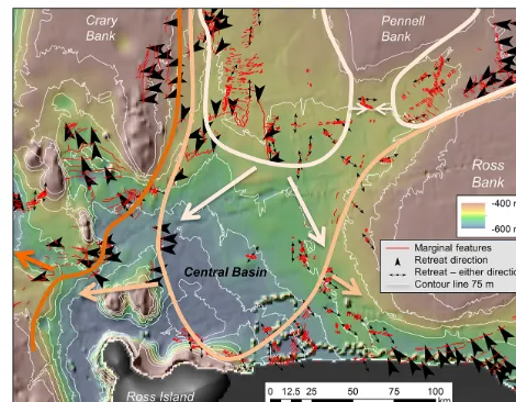
Ice in the deep Central Basin appears to have re-treated quickly, leaving only isolated clusters of recessional moraines. Based on the orientations of these moraines, we interpret a grounding-line embayment that opened over the Central Basin, followed by grounding-line retreat toward the east and west (Fig. 5). Fields of closely spaced, small-scale ice-marginal features in the Central Basin indicate that ice remained in frequent contact with the bed during deglacia-tion of this area. Because ice did not lift off from the deep sea floor first, we infer that retreat behaviour was controlled by a steep ice profile rather than physiography, as the ice did not decouple concentrically according to depth contours.
North of the Central Basin, extensive fields of small-scale GZWs and moraines record grounding-line retreat onto banks (Figs. 6a–b; 7), indicating that ice remained grounded on WRS banks during deglaciation. The presence of GZWs implies that ice was actively flowing across the banks and mobilising sediment in order to deposit these marginal fea-tures. Thus, WRS banks housed semi-independent ice rises during the late stages of ice sheet retreat from the WRS (Shipp et al., 1999; Anderson et al., 2014; Matsuoka et al., 2015). These findings are supported by modelling results that indicate the presence of independent, detached ice rises on WRS banks late in deglaciation (Golledge et al., 2014). Ad-ditionally, Yokoyama et al. (2016) argue that a grounded ice shelf remained pinned on WRS banks until the late Holocene.
5.3 Eastern Ross Sea deglaciation
Linear features on the ERS sea floor are overprinted only by large-scale GZWs (Fig. 3). These large-scale GZWs likely record periods of grounding-line stabilisation, punctuated by episodes of ice-sheet decoupling and grounding-line retreat that back-stepped tens to hundreds of kilometres in distance and preserved linear features.
We propose two alternative scenarios to explain the ob-served changes in flow orientation in the ERS. The first
Figure 5. Retreat direction in the western Ross Sea is inferred from GZWs (arrowheads) and symmetric marginal moraines (double-sided arrows). Reconstructed grounding lines (solid lines) are ac-companied by large arrows indicating regional retreat. Thin white lines are depth contours at 75 m increments. Deglaciation in the deep Central Basin did not follow depth contours, implying a steep deglacial EAIS ice profile in order for ice to remain grounded across a range of depths contemporaneously.
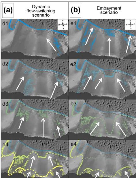
scenario (dynamic flow-switching model) is characterized by alternating regional flow direction throughout the LGM, followed by north–south recession of the grounding line (Fig. 8a). In the second scenario (embayment scenario), the ice stream occupying Whales Deep experienced extensive re-treat, forming a large grounding-line embayment in the ERS (Fig. 8b).
The dynamic flow-switching scenario requires significant flow reorganisation with westward ice flow out of Marie Byrd Land (d1, Fig. 8a) followed by eastward flow across the inter-ice-stream ridge between Whales Deep and Glo-mar Challenger Basin (d2, Fig. 8a). Trough-parallel flow was then established (d3, Fig. 8a) and ice then began to retreat landward from the continental shelf in all ERS basins, inter-rupted by phases of grounding-line stabilisation and forma-tion of the large GZWs in Whales Deep and Glomar Chal-lenger Basin (d4, Fig. 8a). Different generations of MGSLs are preserved as the grounding-line retreats, but we would not expect them to be preserved if a readvance or major new episode of streaming had occurred, remoulding the bedform field. Although there have been examples of preserved flow fabrics during events of flow-switching (Stokes et al., 2009; Winsborrow et al., 2012) or at localised patches of basal fric-tion (Stokes et al., 2007; Kleman and Glasser, 2007), the preservation of such extensive flow fabrics throughout three different ice flow configurations is unlikely.
neigh-Figure 6. (a–b) Grounding lines are observed to retreat up onto banks, as shown by back-stepping wedges and marginal moraines. Arrowheads denote retreat direction. (c) Back-stepping grounding lines in the south-western Glomar Challenger Basin imply that ice had decoupled there before retreating westward into the WRS. The colour scale is consistent between all panels.
bouring inter-ice-stream ridges into Whales Deep (flow sets g, k, Fig. 4). Trough-parallel flow likely occurred first (e1, Fig. 8b), as evidenced by the relatively undisturbed trough-parallel flow set in the outermost part of Whales Deep. Dur-ing trough-parallel flow, ice grounded on inter-ice-stream ridges was likely sluggish and strongly coupled to the bed (Klages et al., 2013). An embayment in the Whales Deep grounding line formed (e2, Fig. 8b), drawing flow from outer Glomar Challenger Basin across the inter-ice-stream ridge into Whales Deep and depositing a large-scale GZW on the mid-shelf (W2, Fig. 3). The grounding-line embayment then retreated further towards the Whales Deep inner shelf (e3, Fig. 8b), drawing ice from Glomar Challenger Basin and
Figure 7. Reconstructed grounding-line retreat across the Ross Sea based on geomorphic indicators of grounding lines (solid lines) and inferred grounding-line locations (dashed). Each line marks a rela-tive step in grounding-line retreat starting with step 1 at the LGM grounding line and ending with step 9 with ice pinned on banks.
Little America Basin, and prompting flow across the inter-ice-stream ridges into Whales Deep. The ice stream feeding Whales Deep at the LGM may have experienced stagnation or outrun its inner-shelf ice source, destabilising grounded ice on the outer shelf and causing an embayment to form. Modern Siple Coast ice streams have been observed to slow and stagnate (Anandakrishnan and Alley, 1997; Joughin and Tulaczyk, 2002), suggesting dynamic behaviour in the past.
Shipp et al. (1999) identify the inter-ice-stream ridges in the ERS as aggradational features, meaning that they were centres of focused sedimentation. Embayment ground-ing lines would have stabilised on the edges of the inter-ice-stream ridges on either side of Whales Deep, transport-ing sediment to these bathymetric features and aggradtransport-ing the inter-ice-stream ridges. A large embayment over the ERS is also compatible with the interpreted WRS deglaciation pat-tern, where a steep EAIS profile is inferred. The formation of an embayment in the ERS is consistent with grounding-line recession in the ERS prior to the WRS (Fig. 6c), followed by east-to-west deglaciation of the WRS.
em-Figure 8. Possible retreat scenarios for the eastern Ross Sea in-terpreted from flow sets. (a) The dynamic flow-switching scenario calls for alternating regional flow directions, followed by north– south recession of the grounding line. This model requires preserva-tion of at least three different flow fabrics as ice remains grounded on the outer continental shelf. (b) In the embayment scenario, a large grounding-line embayment in the eastern Ross Sea forms over Whales Deep. The embayment scenario is independently more consistent with inland palaeo-ice thickness reconstructions and sea floor seismic observations.
bayment scenario is favoured, due to the landform preserva-tion issues inherent to the dynamic flow-switching model.
The Ross Sea geomorphological record permits us to re-construct the pattern of ice flow and retreat independently of a radiocarbon chronology and the associated problems therein. Figure 7 presents reconstructed steps in grounding-line retreat that illustrate deglacial patterns across the Ross Sea. Observed grounding lines are linked together to form discrete episodes of deglaciation. These linkages are based on similar morphologies of observed GZWs, extension of grounding line orientations along bathymetric depth con-tours, and interpretation of local (albeit qualitative) retreat rates based on geomorphic features. The southern Dry-galski Trough was the last area in the WRS to experi-ence grounding-line retreat, as outlet glaciers (e.g. Mackay Glacier and David Glacier flowing into the Drygalski Ice Tongue) receded toward the west and north, leaving fields
of moraines and GZWs (Greenwood et al., 2012; Anderson et al., 2014, Fig. 7). Drainage from the EAIS flowed into the Ross Embayment until the last stage of deglaciation (Fig. 7, steps 7–8). We infer a steep EAIS ice profile over the WRS throughout deglaciation, based on the contribution of EAIS ice through the Transantarctic Mountains and grounding-line recession unaffected by topography in the central WRS (Fig. 5).
5.4 Comparison with existing deglacial models
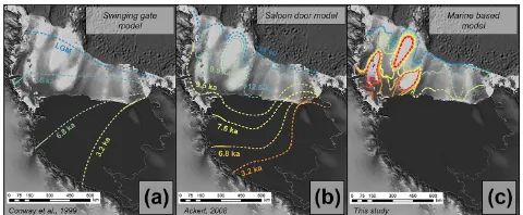
Currently, there are two very different published retreat sce-narios for the Ross Sea (Fig. 9). One of these models, the often cited “swinging gate” model (e.g. McKay et al., 2008; Hall et al., 2013), calls for a linear grounding line retreat across the Ross Sea, hinged just north of Roosevelt Island and extending to the Transantarctic Mountains (Conway et al., 1999). This model is constrained by the initiation of ice-divide flow over Roosevelt Island, and two locations along the Transantarctic Mountains with ages from ice-free coast-lines, and it indicates deglaciation of the WRS at a faster rate than the ERS. The swinging gate model implies that con-trols on ice-sheet dynamics were the same throughout the Ross Sea and that physiography had little influence on ice retreat. This model also implies that ice-sheet retreat from the Ross Sea was controlled mainly by changes in the WAIS catchment, suggesting very high rates of southward retreat along the coast of the Transantarctic Mountains (Conway et al., 1999; Hall et al., 2013, 2015). Alternatively, the “sa-loon door” model proposes early retreat in the ERS with a grounding-line embayment in the central Ross Sea (Ackert, 2008). The implied drainage pattern of the saloon door model requires significant inputs from both the EAIS and the WAIS. This model is supported by cosmogenic exposure ages in-dicating a thinner ice-sheet profile in the central Ross Sea than at the margins of the WAIS (Parizek and Alley, 2004; Waddington et al., 2005; Anderson et al., 2014).
Figure 9. Comparison of existing models of Ross Sea deglaciation. (a) The “swinging gate model” (Conway et al., 1999) assumes a lin-ear grounding line swinging across the Ross Sea, implying that con-trols on ice-sheet dynamics are the same throughout the Ross Sea and that physiography has little influence on ice retreat. This model indicates deglaciation of the WRS prior to the ERS, and implies that the Ross Sea was filled with WAIS ice during LGM and throughout deglaciation. (b) The “saloon door” model of deglaciation suggests early retreat in the ERS with a potential grounding-line embayment in the central Ross Sea (Ackert, 2008), requiring significant inputs from both the EAIS and the WAIS. (c) The marine-based recon-struction presented here uses glacial geomorphology to interpret palaeo-grounding-line retreat.
Neither the swinging gate nor the saloon door model in-corporate observations from the continental shelf, and, as we show here, are not able to fully capture the complex-ity of grounding-line retreat across the Ross Sea. Our new marine-based model (Fig. 7), reconstructed from comprehen-sive mapping of sea floor geomorphic features that directly record grounding-line retreat, can now be used to interpret more detailed Ross Sea palaeo-ice sheet behaviour and iden-tify regional differences in deglacial behaviour. Our glacial geomorphic reconstruction independently converges with re-cent numerical modelling. Model results demonstrate signif-icant EAIS and WAIS contributions to ice flow in the Ross Sea, and suggest that deglaciation was initiated in Ross Sea troughs and influenced by bedrock highs (Golledge et al., 2014; DeConto and Pollard, 2016; McKay et al., 2016). Ad-ditionally, DeConto and Pollard (2016) reproduce an early ERS grounding-line embayment confined to Whales Deep and a WRS Central Basin embayment receding to the east and west, while Golledge et al. (2014) simulate repeated oc-cupation of WRS banks by semi-independent ice rises. Re-gional reconstructions between models and geologic obser-vations are therefore becoming more and more consistent; however, smaller-scale patterns of grounding-line retreat are not yet reproduced at the resolution of modern numerical models. These localised retreat patterns are important for un-derstanding grounding-line dynamics and smaller-scale pro-cesses that drive regional ice behaviour. A key target for fur-ther refining such efforts must undoubtedly be a robust and reliable radiocarbon chronology.
5.5 Physiographic and geological controls on deglaciation
Many cycles of glacial erosion and deposition have led to Antarctic continental shelves characterised by a fore-deepened shelf profile with exposed bedrock on the inner shelf and thicker sediments on the outer shelf (Anderson, 1999). Runaway grounding-line retreat can occur as ice re-treats from the outer to inner shelf due to a lack of pin-ning points to stabilise the grounding line (e.g. Mercer, 1978; Jamieson et al., 2012). In the WRS, banks and volcanic seamounts provided stable pinning points during deglacia-tion (Anderson et al., 2014; Simkins et al., 2016), and bathy-metric highs continue to stabilise the modern Siple Coast ice sheet and ice shelf (Matsuoka et al., 2015). Ice-marginal fea-tures are observed to back-step up onto WRS banks (Fig. 6), demonstrating a strong physiographic control on grounding line behaviour. These banks served as pinning points for re-treating ice streams and likely evolved into semi-independent ice rises during deglaciation. WRS banks supported an ex-tensive ice shelf that buttressed WRS grounding lines and contributed to the long-lived presence of the EAIS in the WRS (Anderson et al., 2014; Yokoyama et al., 2016). While slight bottlenecking of ERS inter-ice-stream ridges may have played a role in determining positions of grounding-line sta-bility and the formation of large-scale GZWs (Mosola and Anderson, 2006), the ERS sea floor is much more topograph-ically subdued than in the WRS. A lack of high-relief banks and troughs permitted more variable flow in the ERS, but did not allow for pinning and stabilisation of ice streams as oc-curred in the WRS.
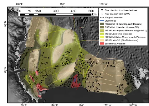
The compilation of geological data in Fig. 10 shows the strata beneath the most recent observable glacial erosional surface, representing the substrate that ice flowing across the continental shelf at the LGM would have encountered. The degree of consolidation of these strata is derived from infor-mation obtained from drill cores collected during Deep Sea Drilling Project Leg 28, extrapolated to high-resolution seis-mic stratigraphic correlations across the Ross Sea (Alonso et al., 1992; Anderson and Bartek, 1992; Anderson, 1999; Bart et al., 2000). The WRS is characterized by more variable ge-ology and by older substrate, while mostly unconsolidated Plio-Pleistocene sediments blanket the ERS shelf. Thick and extensive unconsolidated sediments likely contributed to a pervasive layer of deformation till in the ERS (Mosola and Anderson, 2006). This thick layer of deformation till facili-tated fast flowing ice and transported sediment to large-scale GZWs through a classic till conveyor-belt mechanism. Fast-flowing ice likely contributed to a low-profile ice sheet that episodically decoupled from the sea floor during retreat from the continental shelf (Mosola and Anderson, 2006). More consolidated strata outcropping in the WRS may have lim-ited such pervasive subglacial deformation, potentially caus-ing slower ice stream velocities in WRS troughs. This char-acteristic sea floor geology, coupled with numerous pinning points, was conducive to a higher profile ice sheet that re-mained in contact with the sea floor throughout much of its retreat from the continental shelf.
Grounded ice in Little America Basin flowed over its east-ern bank and converged with an outlet glacier draining Marie Byrd Land (flow set n, Fig. 4). This flow pattern implies that at one point, Little America Basin was not able to drain all of the ice flowing into it and therefore some of that ice was forced eastward out of the trough. During the LGM, Little America Basin ice streams flowed across late Oligocene and Miocene sedimentary rocks (Fig. 10). Thus, it was more re-sistant to ductile subglacial deformation than the substrates encountered by other ice streams flowing across the ERS. Resulting flow velocities were therefore not high enough to transport all of the ice entering Little America Basin outlet, some of which was captured and funnelled into the neigh-bouring outlet.
Physiography exerts a first-order control on regional ice stream flow and retreat dynamics, and sea floor geology plays an important subsidiary role in controlling ice behaviour. These controls influence regional retreat patterns; more lo-calised ice behaviour is still under investigation. Numerous other processes affect glacial dynamics, such as ice-shelf but-tressing, sediment shear strength, and ice-bed coupling, and subglacial meltwater (e.g. Boulton et al., 2001; Dupont and Alley, 2005; Stearns et al., 2008). External forcings such as tidal effects, circumpolar deep water incursion and under-melting of ice shelves, as well as atmospheric effects are also influential (e.g. Rignot, 1998; Zwally et al., 2002; Arneborg et al., 2012; Walker et al., 2013). Ross Sea retreat was asyn-chronous between troughs, suggesting differential responses
Figure 10. Control of sea floor geology on ice dynamics. Geologic boundaries were interpolated from legacy seismic lines (shown here) with pre-interpreted seismic units by Anderson and Bartek (1992) and Brancolini et al. (1995). The WRS is characterized by complex, older, and more consolidated strata, where ice streams have eroded down to Oligocene-age strata. Volcanic islands and seamounts outcrop in the southern portion of the WRS. The west-ern side of Glomar Challenger Basin, bordering Ross Bank, con-tains older and more variable geologic strata outcropping at the sea floor, including a patch of basement outcrop on the inner shelf. In general, thick unconsolidated Plio-Pleistocene strata fill most of the ERS and increase in thickness in an offshore direction (Alonso et al., 1992). Plio-Pleistocene sediments are thin in southern Whales Deep, overlying older Miocene strata. Eastern Little America Basin is characterized by lithified late Oligocene through Miocene de-posits. Arrows indicating flow direction are based on geomorphic features.
to these processes. Ongoing work on characterising Ross Sea glacial geomorphology highlights the effect of these forcings on local grounding-line stability.
6 Conclusions
During the LGM, grounded ice reached the continental shelf break in the ERS, but not in the WRS. The WRS sea floor is characterized by geomorphic features that indicate periods of rapid recession following the LGM, and record the persis-tent presence of a steep-profiled EAIS in the WRS through-out deglaciation. Retreat in the ERS was likely initiated by the formation of a large grounding-line embayment across Whales Deep. Based on the interpretation of glacial geomor-phic features, Glomar Challenger Basin in the ERS is be-lieved to have been completely deglaciated prior to retreat of grounded ice from the deep Central Basin in the WRS.
shelf, describing a mode of deglaciation that may have oc-curred in more than one sector as ice retreated into its compo-nent sub-catchments. Based on this study, we conclude that it is eminently clear that deglaciation across the Ross Sea shelf did not involve a linear grounding line across the multiple troughs and banks. Additional analyses of Ross Sea conti-nental shelf sedimentology and additional reliable radiocar-bon ages marking grounding-line retreat are necessary to test and refine the deglacial patterns proposed here. A radiocar-bon chronology will help integrate our grounding-line recon-struction with previous work done on Ross Sea deglacial his-tory.
Major differences between regional retreat characteris-tics are attributed to physiography. Ice was pinned on the high-relief banks in the WRS, whereas the lack of com-parable features in the ERS indicates that the WAIS was not stabilised by pinning points. Similar physiographic con-trols are likely buttressing the modern Siple Coast ground-ing line. Seafloor geology played a secondary role in influ-encing palaeodrainage patterns. Younger and relatively un-consolidated Plio-Pleistocene sediments in the ERS, with the exception of the Little America Trough, are associated with fast ice flow, whereas the older and more consolidated strata that characterized the WRS sea floor may have hin-dered pervasive till deformation and contributed to slower ice-stream velocities. These observations can be generalized to other locations with regional sea floor geologic variation, such as the Weddell Sea Embayment. The controls on flow behaviour and retreat patterns revealed in our new Ross Sea deglacial reconstruction can now be incorporated into fu-ture work on understanding marine ice-sheet behaviour at the modern grounding line and across the Antarctic continental shelf.
The Supplement related to this article is available online at doi:10.5194/tc-10-1003-2016-supplement.
Acknowledgements. This research was funded by the National
Science Foundation (NSF-PLR 1246353 to J.B.A) and the Swedish Research Council (D0567301 to S.L.G.). The authors thank the crew of the RV/IB Nathaniel B. Palmer and Antarctic Support Contract staff, as well as Phil Bart, chief scientist, for a successful cruise. We thank Kathleen Gavahan for providing assistance with multibeam data sets, students from Rice University, University of Houston and Louisiana State University for participating in data collection and processing, and Jean Aroom and the Fondren GIS Center, Rice University, for technical support.
Edited by: C. R. Stokes
References
Ackert, R.: Swinging gate or Saloon doors: Do we need a new model of Ross Sea deglaciation?, Fifteenth West Antarctic Ice Sheet Meeting, Sterling, Virginia, 8–11 October 2008.
Alley, R. B., Blankenship, D. D., Bentley, C. R., and Rooney, S. T.: Deformation of till beneath ice stream B, West Antarctica, Nature, 322, 57–59, doi:10.1038/322057a0, 1986.
Alley, R. B., Blankenship, D. D., Bentley, C. R., and Rooney, S. T.: Till beneath ice stream B, 4. Till deformation: ev-idence and implications, J. Geophys. Res., 92, 8921–8929, doi:10.1029/JB092iB09p08921, 1989.
Alley, R. B., Anandakrishnan, S., Dupont, T. K., Parizek, B. R., and Pollard, D.: Effect of sedimentation on ice-sheet grounding-line stability, Science, 315, 1838–1841, doi:10.1126/science.1138396, 2007.
Alonso, B., Anderson, J. B., Diaz, J. T., and Bartek, L. R.: Pliocene-Pleistocene seismic stratigraphy of the Ross Sea: evi-dence for multiple ice sheet grounding episodes, in: Contribu-tions to Antarctic Research III, Antarctic Research Series, vol. 57, edited by: Elliot, D. H., American Geophysical Union, Wash-ington D.C, 93–103, doi:10.1029/AR057p0093, 1992.
Anandakrishnan, S. and Alley, R. B.: Stagnation of ice stream C, West Antarctica by water piracy, Geophys. Res. Lett., 24, 265– 268, doi:10.1029/96GL04016, 1997.
Anandakrishnan, S., Catania, G. A., Alley, R. B., and Horgan, H. J.: Discovery of till deposition at the grounding line of Whillans Ice Stream, Science, 315, 1835–1838, doi:10.1126/science.1138393, 2007.
Anderson, J. B.: Antarctic Marine Geology, Cambridge University Press, New York, 1999.
Anderson, J. B. and Bartek, L. R.: Cenozoic glacial history of the Ross Sea revealed by intermediate resolution seismic reflection data combined with drill site information, in Antarctic Research Series, vol. 56, edited by: Kennett, J. P., American Geophysical Union, Washington D.C., 231–263, doi:10.1029/AR056p0231, 1992.
Anderson, J. B. and Fretwell, L. O.: Geomorphology of the on-set area of a paleo-ice stream, Marguerite Bay, Antarctic Penin-sula, Earth Surf. Proc. Land, 33, 503–512, doi:10.1002/esp.1662, 2008.
Anderson, J. B., Brake, C. F., and Myers, N. C.: Sedimentation on the Ross Sea continental shelf, Antarctica, Mar. Geol., 57, 295– 333, doi:10.1016/0025-3227(84)90203-2, 1984.
Anderson, J. B., Conway, H., Bart, P. J., Witus, A. E., Greenwood, S. L., McKay, R. M., Hall, B. L., Ackert, R. P., Licht, K., Jakobs-son, M., and Stone, J. O.: Ross Sea Paleo-Ice Sheet Drainage and Deglacial History During and Since the LGM, Quaternary Sci. Rev., 100, 31–54, doi:10.1016/j.quascirev.2013.08.020, 2014. Arneborg, L., Wåhlin, A. K., Björk, G., Liljebladh, B., and Orsi, A.
H.: Persistent inflow of warm water onto the central Amundsen shelf, Nat. Geosci., 5, 876–880, doi:10.1038/ngeo1644, 2012. Bart, P. J. and Cone, A. N.: Early stall of West Antarctic Ice Sheet
advance on the eastern Ross Sea middle shelf followed by retreat at 27,500 14C yr BP, Palaeogeogr. Palaeocl., 335–336, 52–60, doi:10.1016/j.palaeo.2011.08.007, 2012.
Bart, P. J., Anderson, J. B., Trincardi, F., and Shipp, S. S.: Seismic data from the Northern Basin, Ross Sea, record multiple expan-sions of the East Antarctic Ice Sheet during the late Neogene, Mar. Geol., 166, 31–50, doi:10.1016/S0025-3227(00)00006-2, 2000.
Batchelor, C. L. and Dowdeswell, J. A.: Ice-sheet grounding-zone wedges (GZWs) on high-latitude continental margins, Mar. Geol., 363, 65–92, doi:10.1016/j.margeo.2015.02.001, 2015. Benn, D. I. and Evans, D. J. A.: Glaciers and Glaciation, 2, Hodder
Education, London, UK, 2010.
Bentley, M. J., O’Cofaigh, C., Anderson, J. B., Conway, H., Davies, B., Graham, A. G. C., Hillenbrand, C. D., Hodgson, D. A., Jamieson, S. S. R., Larter, R. D., Mackintosh, A., Smith, J. A., Verleyen, E., Ackert, R. P., Bart, P. J., Berg, S., Brunstein, D., Canals, M., Colhoun, E. A., Crosta, X., Dickens, W. A., Do-mack, E., Dowdeswell, J. A., Dunbar, R., Ehrmann, W., Evans, J., Favier, V., Fink, D., Fogwill, C. J., Glasser, N. F., Gohl, K., Golledge, N. R., Goodwin, I., Gore, D. B., Greenwood, S. L., Hall, B. L., Hall, K., Hedding, D. W., Hein, A. S., Hocking, E. P., Jakobsson, M., Johnson, J. S., Jomelli, V., Jones, R. S., Klages, J. P., Kristoffersen, Y., Kuhn, G., Leventer, A., Licht, K., Lilly, K., Lindow, J., Livingstone, S.J., Massè, G., McGlone, M. S., McKay, R. M., Melles, M., Miura, H., Mulvaney, R., Nel, W., Nitsche, F. O., O’Brien, P. E., Post, A. L., Roberts, S. J., Saunders, K. M., Selkirk, P. M., Simms, A. R., Spiegel, C., Stolldorf, T. D., Sugden, D. E., van der Putten, N., van Ommen, T., Verfaillie, D., Vyverman, W., Wagner, B., White, D. A., Witus, A. E., and Zwartz, D.: A community-based geo-logical reconstruction of Antarctic Ice Sheet deglaciation since the Last Glacial Maximum, Quaternary Sci. Rev., 100, 1–9, doi:10.1016/j.quascirev.2014.06.025, 2014.
Bevis, M., Kendrick, E., Smalley, R., Dalziel, I., Caccamise, D., Sasgen, I., Helsen, M., Taylor, F. W., Zhou, H., Brown, A., Raleigh, D., Willis, M., Wilson, T., and Konfal, S.: Geodetic measurements of vertical crustal velocity in West Antarctica and the implications for ice mass balance, Geochem. Geophys. Geosyst., 10, Q10005, doi:10.1029/2009GC002642, 2009. Boulton, G. S., Dobbie, K. E., and Zatsepin, S.: Sediment
de-formation beneath glaciers and its coupling to the subglacial hydraulic system, Quatern. Int., 86, 3–28, doi:10.1016/S1040-6182(01)00048-9, 2001.
Brancolini, G.: ANDOSTRAT Project, in: Geology and Seismic Stratigraphy of the Antarctic Margin, Antarctic Research Series, edited by: Cooper, A. K., Barker, P. F., and Brancolini, G., vol. 68, American Geophysical Union, Washington D.C., 1995. Brunt, K. M., Fricker, H. A., Padman, L., Scambos, T. A., and
O’Neel, S.: Mapping the grounding zone of Ross Ice Shelf, Antarctica, using ICESat laser altimetry, Ann. Glaciol., 51, 71– 79, doi:10.3189/172756410791392790, 2010.
Clark, C. D.: Mega-scale glacial lineations and cross-cutting ice flow landforms, Earth Surf. Proc. Land., 18, 1–29, doi:10.1002/esp.3290180102, 1993.
Clark, C. D.: Glaciodynamic context of subglacial bedform generation and preservation, Ann. Glaciol., 28, 23–32, doi:10.3189/172756499781821832, 1999.
Conway, H., Hall, B. L., Denton, G. H., Gades, A. M., and Waddington, E. D.: Past and future grounding-line retreat of the West Antarctic Ice Sheet, Science, 286, 280–283, doi:10.1126/science.286.5438.280, 1999.
Cooper, A. K., Barrett, P. J., Hinz, K., Traube, V., Leitchenkov, G., and Stagg, H. M. J.: Cenozoic prograding sequences of the Antarctic continental margin – a record of glacioeustatic and tectonic events, Mar. Geol., 102, 175–213, doi:10.1016/0025-3227(91)90008-R, 1991.
Cunningham, W. L., Leventer, A., Andrews, J. T., Jennings, A. E., and Licht, K. J.: Late Pleistocene–Holocene marine conditions in the Ross Sea, Antarctica: evidence from the diatom record, The Holocene, 9, 129–139, doi:10.1191/095968399675624796, 1999.
DeConto, R. M. and Pollard, D.: Contribution of Antarctica to past and future sea-level rise, Nature, 531, 591–597, doi:10.1038/nature17145, 2016.
DeSantis, L., Anderson, J. B., Brancolini, G., and Zayatz, I.: Glaciomarine deposits on the continental shelf of Ross Sea, Antarctica, in: Glaciated Continental Margins: An Atlas of Acoustic Images, edited by: Davies, T. A., Bell, T., Cooper, A. K., Josenhans, H., Polyak, L., Solheim, A., Stoker, M. S., and Stravers, J. A., Chapman & Hall, London, UK, 110–113, 1997. Denton, G. H. and Marchant, D.: The geologic basis for a
recon-struction of a grounded ice sheet in McMurdo Sound, Antarc-tica, at the last glacial maximum, Geogr. Ann. A., 82, 167–212, doi:10.1111/j.0435-3676.2000.00121.x, 2000.
Dowdeswell, J. A. and Fugelli, E. M. G.: The seismic architecture and geometry of grounding-zone wedges formed at the marine margins of past ice sheets, Geol. Soc. Am. Bull., 124, 1750– 1761, doi:10.1130/B30628.1, 2012.
Dowdeswell, J. A., Ó Cofaigh, C., and Pudsey, C. J.: Thickness and extent of the subglacial till layer beneath an Antarctic paleo–ice stream, Geology, 32, 13–16, doi:10.1130/G19864.1, 2004. Dowdeswell, J. A., Ottesen, D., Evans, J., O’Cofaigh, C.
O., and Anderson, J. B.: Submarine glacial landforms and rates of ice-stream collapse, Geology, 36, 819–822, doi:10.1130/G24808A.1, 2008.
Dupont, T. K. and Alley, R. B.: Assessment of the importance of ice-shelf buttressing to ice-sheet flow, Geophys. Res. Lett., 32, L04503, doi:10.1029/2004GL022024, 2005.
Evans, J., Pudsey, C. J., Ó Cofaigh, C., Morris, P. W., and Domack, E. W.: Late Quaternary glacial history, dynam-ics and sedimentation of the eastern margin of the Antarc-tic Peninsula Ice Sheet, Quaternary Sci. Rev., 24, 741–774, doi:10.1016/j.quascirev.2004.10.007, 2005.
Farmer, G. L., Licht, K., Swope, R. J., and Andrews, J. T.: Iso-topic constraints on the provenance of fine-grained sediment in LGM tills from the Ross Embayment, Antarctica, Earth Planet. Sc. Lett., 249, 90–107, doi:10.1016/j.epsl.2006.06.044, 2006. Fowler, A. C.: The formation of subglacial streams and mega-scale
glacial lineations, P. Roy. Soc. A-Math. Phy., 466, 3181–3201, doi:10.1098/rspa.2010.0009, 2010.
Rivera, A., Roberts, J., Ross, N., Siegert, M. J., Smith, A. M., Steinhage, D., Studinger, M., Sun, B., Tinto, B. K., Welch, B. C., Wilson, D., Young, D. A., Xiangbin, C., and Zirizzotti, A.: Bedmap2: improved ice bed, surface and thickness datasets for Antarctica, The Cryosphere, 7, 375–393, doi:10.5194/tc-7-375-2013, 2013.
Fricker, H. A. and Padman L.: Ice shelf grounding zone structure from ICESat laser altimetry, Geophys. Res. Lett., 33, L15502, doi:10.1029/2006GL026907, 2006.
Gales, J. A., Larter, R. D., Mitchell, N. C., Hillenbrand, C.-D., Østerhus, S., and Shoosmith, D. R.: Southern Weddell Sea shelf edge geomorphology: implications for gully formation by the overflow of high-salinity water, J. Geophys. Res., 117, F0402, doi:10.1029/2012JF002357, 2012.
Golledge, N. R., Levy, R. H., McKay, R. M., Fogwill, C. J., White, D. A., Graham, A. G. C., Smith, J. A., Hillenbrand, C.-D., Licht, K. J., Denton, G. H., Ackert, R. P., Maas, S. M., and Hall, B. L.: Glaciology and geological signature of the Last Glacial Max-imum Antarctic ice sheet, Quaternary Sci. Rev., 78, 225–247, doi:10.1016/j.quascirev.2013.08.011, 2013.
Golledge, N. R., Menviel, L., Carter, L., Fogwill, C. J., England, M. H., Cortese, G., and Levy, R. H.: Antarctic contribution to meltwater pulse 1A from reduced Southern Ocean overturning, Nat. Commun., 5, 5107, doi:10.1038/ncomms6107, 2014. Graham, A. G. C., Later, R. D., Gohl, K., Hillenbrand, C.-D,
Smith, J. A., and Kuhn, G.: Bedform signature of a West Antarctic palaeo-ice stream reveals a multi-temporal record of flow and substrate control, Quaternary Sci. Rev., 28, 2774–279, doi:10.1016/j.quascirev.2009.07.003, 2009.
Graham, A. G. C., Dutrieuz, P., Vaughan, D. G., Nitsche, F. O., Gyllencreutz, R., Greenwood, S. L., Larter, R. D., and Jenkins, A.: Seabed corrugations beneath an Antarctic ice shelf revealed by autonomous underwater vehicle survey: Origin and implica-tions for the history of Pine Island Glacier, J. Geophys. Res., 118, 1356–1366, doi:10.1002/jgrf.20087, 2013.
Greenwood, S. L., Gyllencreutz, R., Jakobsson, M., and Anderson, J. B.: Ice-flow switching and East/West Antarctic Ice Sheet roles in glaciation of the western Ross Sea, Geol. Soc. Am. Bull., 124, 1736–1749, doi:10.1130/B30643.1, 2012.
Hall, B. L. and Denton, G. H.: Radiocarbon Chronology of Ross Sea Drift, Eastern Taylor Valley, Antarctica: Evidence for a Grounded Ice Sheet in the Ross Sea at the Last Glacial Maximum, Geogr. Ann. A., 82, 205–336, doi:10.1111/j.0435-3676.2000.00127.x, 2000.
Hall, B. L., Baroni, C., and Denton, G. H.: Holocene relative sea-level history of the Southern Victoria Land Coast, Antarctica, Global Planet. Change, 42, 241–263, doi:10.1016/j.gloplacha.2003.09.004, 2004.
Hall, B. L., Henderson, G. M., Baroni, C., and Kellogg, T. B.: Constant Holocene Southern-Ocean 14C reservoir ages and ice-shelf flow rates, Earth Planet. Sc. Lett., 296, 115–123, doi:10.1016/j.epsl.2010.04.054, 2010.
Hall, B. L., Denton, G. H., Stone, J. O., and Conway, H.: History of the grounded ice sheet in the Ross Sea sector of Antarctica during the Last Glacial Maximum and the last termination, Geol. Soc. Lond., 381, 167–181, doi:10.1144/SP381.5, 2013. Hall, B. L., Denton, G. H., Heath, S. L., Jackson, M. S., and
Koff-man, T. N.: Accumulation and marine forcing of ice dynamics in
the western Ross Sea during the last deglaciation, Nat. Geosci., 8, 625–628, doi:10.1038/ngeo2478, 2015.
Heroy, D. C. and Anderson, J. B.: Ice-sheet extent of the Antarctic Peninsula region during the Last Glacial Maximum (LGM) – in-sights from glacial geomorphology, Geol. Soc. Am. Bull., 117, 1497–1512, doi:10.1130/B25694.1, 2005.
Hoppe, G.: Glacial morphology and inland ice recession in northern Sweden, Geogr. Ann., 41, 193–212, 1959.
Howat, I. M. and Domack, E. W.: Reconstructions of western Ross Sea palaeo-ice-stream grounding zones from high-resolution acoustic stratigraphy, Boreas, 32, 56–75, doi:10.1111/j.1502-3885.2003.tb01431.x, 2003.
Jakobsson, M., Anderson, J. B., Nitsche, F. O., Dowdeswell, J. A., Gyllencreutz, R., Kirchner, N., Mohammad, R., O’Regan, M., Alley, R. B., Anandakrishnan, S., Eriksson, B., Kirshner, A., Fernandez, R., Stolldorf, T., Minzoni, R., and Majewski, W.: Geological record of ice shelf break-up and grounding line re-treat, Pine Island Bay, West Antarctica, Geology, 39, 691–694, doi:10.1130/G32153.1, 2011.
Jakobsson, M., Anderson, J. B., Nitsche, F. O., Gyllencreutz, R., Kirshner, A. E., Kirchner, N., O’Regan, M., Moham-mad, R., and Eriksson, B.: Ice sheet retreat dynamics in-ferred from glacial morphology of the central Pine Island Bay Trough, West Antarctica, Quaternary Sci. Rev., 38, 1–10, doi:10.1016/j.quascirev.2011.12.017, 2012.
Jamieson, S. S. R., Vieli, A., Livingstone, S. J., Ó. Cofaigh, C. , Stokes, C., Hillenbrand, C.-D., and Dowdeswell, J. A.: Ice-stream stability on a reverse bed slope, Nat. Geosci., 5, 799–802, doi:10.1038/ngeo1600, 2012.
Jones, R. S., Mackintosh, A. N., Norton, K. P., Golledge, N. R., Fogwill, C. J., Kubik, P. W., Christl, M., and Greenwood, S. L.: Rapid Holocene thinning of an East Antarctic outlet glacier driven by marine ice sheet instability, Nat. Commun., 6, 8910, doi:10.1038/ncomms9910, 2015.
Joughin, I. and Tulaczyk, S.: Positive mass balance of the Ross Ice Streams, West Antarctica, Science, 295, 476–480, doi:10.1126/science.1066875, 2002.
King, E. C., Hindmarsh, R. C., and Stokes, C. R.: Formation of mega-scale glacial lineations observed beneath a West Antarctic ice stream, Nat. Geosci., 2, 585–588, doi:10.1038/ngeo581, 2009 Klages, J. P., Kuhn, G., Hillenbrand, C.-D., Graham, A. G. C., Smith, J. A., Larter, R. D., and Gohl, K.: First geomorpholog-ical record and glacial history of an inter-ice stream ridge on the West Antarctic continental shelf, Quaternary Sci. Rev., 61, 47– 61, doi:10.1016/j.quascirev.2012.11.007, 2013.
Klages, J. P., Kuhn, G., Graham, A. G. C., Hillenbrand, C.-D., Smith, J. A., Nitsche, F. O., Larter, R. D., and Gohl, K.: Palaeo-ice stream pathways and retreat style in the easternmost Amund-sen Sea Embayment, West Antarctica, revealed by combined multibeam bathymetric and seismic data, Geomorphology, 245, 207–222, doi:10.1016/j.geomorph.2015.05.020, 2015.
Kleman, J. and Glasser, N. F.: The subglacial thermal organisa-tion (STO) of ice sheets, Quaternary Sci. Rev., 26, 585–597, doi:10.1016/j.quascirev.2006.12.010, 2007.