www.atmos-meas-tech.net/8/3419/2015/ doi:10.5194/amt-8-3419-2015
© Author(s) 2015. CC Attribution 3.0 License.
Exploiting the sensitivity of two satellite cloud height retrievals to
cloud vertical distribution
C. K. Carbajal Henken1, L. Doppler2, R. Lindstrot3, R. Preusker1, and J. Fischer1 1Institute for Space Sciences, Freie Universität Berlin (FUB), Berlin, Germany
2Deutscher Wetterdienst, Meteorologisches Observatorium Lindenberg, Richard Assmann
Observatorium (DWD, MOL-RAO), Lindenberg, Germany 3EUMETSAT, Eumetsat-Allee 1, Darmstadt, Germany
Correspondence to: C. K. Carbajal Henken (cintia.carbajal@wew.fu-berlin.de)
Received: 27 January 2015 – Published in Atmos. Meas. Tech. Discuss.: 12 March 2015 Revised: 16 July 2015 – Accepted: 4 August 2015 – Published: 24 August 2015
Abstract. This work presents a study on the sensitivity of two satellite cloud height retrievals to cloud vertical distri-bution. The difference in sensitivity is exploited by relating the difference in the retrieved cloud heights to cloud verti-cal extent. The two cloud height retrievals, performed within the Freie Universität Berlin AATSR MERIS Cloud (FAME-C) algorithm, are based on independent measurements and different retrieval techniques. First, cloud-top temperature (CTT) is retrieved from Advanced Along Track Scanning Radiometer (AATSR) measurements in the thermal infrared. Second, cloud-top pressure (CTP) is retrieved from Medium Resolution Imaging Spectrometer (MERIS) measurements in the oxygen-A absorption band and a nearby window channel. Both CTT and CTP are converted to cloud-top height (CTH) using atmospheric profiles from a numerical weather predic-tion model. First, a sensitivity study using radiative transfer simulations in the near-infrared and thermal infrared was per-formed to demonstrate, in a quantitative manner, the larger impact of the assumed cloud vertical extinction profile, de-scribed in terms of shape and vertical extent, on MERIS than on AATSR top-of-atmosphere measurements. Consequently, cloud vertical extinction profiles will have a larger influence on the MERIS than on the AATSR cloud height retrievals for most cloud types.
Second, the difference in retrieved CTH (1CTH) from AATSR and MERIS are related to cloud vertical extent (CVE), as observed by ground-based lidar and radar at three ARM sites. To increase the impact of the cloud vertical ex-tinction profile on the MERIS-CTP retrievals, single-layer and geometrically thin clouds are assumed in the forward
model. Similarly to previous findings, the MERIS-CTP re-trievals appear to be close to pressure levels in the middle of the cloud. Assuming a linear relationship, the1CTH multi-plied by 2.5 gives an estimate on the CVE for single-layer clouds. The relationship is stronger for single-layer clouds than for multi-layer clouds. Due to large variations of cloud vertical extinction profiles occurring in nature, a quantita-tive estimate of the cloud vertical extent is accompanied with large uncertainties.
Yet, estimates of the CVE provide an additional parame-ter, next to CTH, that can be obtained from passive imager measurements and can be used to further describe cloud ver-tical distribution, thus contributing to the characterization of a cloudy scene.
1 Introduction
The vertical distribution of clouds plays an important role in both meteorological and climatological applications. It can be an indicator of the meteorological conditions, (thermo-)dynamical and micro-physical processes, in which a cloud forms (e.g., Yin et al., 2013; Yuan et al., 2011; Luo et al., 2009). Further, the cloud vertical distribution affects radia-tive and latent heating fluxes, which in turn, affect the large-scale atmospheric circulation and precipitation processes (e.g., Wang and Rossow, 1998; Li et al., 2014).
Cloud vertical distribution can be described by a set of cloud parameters, such as top height (CTH) and cloud-base height, and subsequently cloud geometrical thickness (CGT), and the number of distinct cloud layers in an air col-umn. These cloud parameters can be observed by a set of remote-sensing techniques using observations from ground-based or space-born instruments.
From ground-based observations information on cloud vertical distribution can be derived from, e.g., human ob-servers, lidars, and radars. The first two only observe the cloud-base height, while radar can observe the cloud verti-cal profile. However, the spatial coverage of these ground-based observations are mainly limited to land areas in the Northern Hemisphere. Global and accurate observations of cloud vertical distribution are necessary for an improved understanding of cloud processes, and subsequently im-proved representations of these processes in climate mod-els. Satellite observations can provide this global cover-age. In 2005, the active instruments CPR (Cloud Profil-ing Radar) and CALIOP (Cloud-Aerosol Lidar with Or-thogonal Polarization), on polar-orbiting satellites CloudSat (Stephens et al., 2002) and CALIPSO (Cloud-Aerosol Lidar and Infrared Pathfinder Satellite Observations) (Winker et al., 2003), respectively, as part of the A-train constellation, were launched. They provide first radar and lidar measurements on cloud and aerosol vertical profiles on a global scale. Since then both instruments have given the atmospheric research community many new insights on clouds and aerosols (e.g., Mace et al., 2007; Sassen et al., 2008) and their observa-tions were extensively used in many evaluation studies (e.g., Naud et al., 2010; Weisz et al., 2007). However, they have a poor spatial coverage due to the nadir-only measurements and, especially for weather related applications, would ben-efit from supplement observations on cloud vertical distri-butions. Moreover, in contrast to various space-born passive imagers, no long-term measurement data sets exist, which are relevant for many climate studies.
Satellite observations from passive instruments have a larger spatial coverage. However, here the cloud properties are retrieved from information coming mainly from upper cloud layers, such as cloud-top temperature, or they represent an integrated property, such as cloud water path. A number of satellite remote sensing techniques exist that retrieve cloud-top heights (CTHs) from measurements of passive imagers.
Cloud-top height retrievals from thermal infrared (TIR) mea-surements have been performed using the CO2slicing tech-nique (e.g., Menzel et al., 2008) or with brightness tempera-ture (BT) measurements in window channels (e.g., Hamann et al., 2014; Korpela et al., 2001). Further, CTHs can be ob-tained from stereo, which is based on the parallax effect oc-curring between clouds observed from different viewing an-gles (e.g., Moroney et al., 2002). In Wu et al. (2009), verti-cal and latitudinal distributions of cloud height observations from various passive and active satellite instruments are com-pared. Here, also a discussion on the strengths and weak-nesses of various passive CTH retrieval techniques, which depend on cloud conditions, is given. Also in Naud et al. (2005) intercomparisons were performed for several passive and active cloud-top height retrievals.
In 1961, Yamamoto and Wark (1961) proposed to retrieve cloud-top altitude from space by measuring the absorption of reflected solar radiation in the oxygen-A absorption band located at around 760 nm. In the method the strength of the absorption of radiation in the oxygen-A absorption band is related to the cloud-top pressure (CTP), via the mean pho-ton path length. Later in the 1960s, first satellite retrievals using the oxygA absorption band showed that the en-hancement of photon path length due to multiple scatter-ing inside the cloud, which in turn depends on cloud thick-ness and type, needs to be taken into account for accurate CTP retrievals (Saiedy et al., 1965, 1967). The impact of the cloud vertical inhomogeneity on the accuracy of the CTP re-trievals has been recognized in a number of theoretical stud-ies (Fischer and Grassl, 1991; Rozanov and Kokhanovsky, 2004; Preusker and Lindstrot, 2009). Various cloud height re-trievals based on measurements in the oxygen-A absorption band are described in, e.g., Wang et al. (2008); Rozanov and Kokhanovsky (2004); Koelemeijer et al. (2002); Vanbauce et al. (1998). In most of these cloud height retrievals, multi-ple scattering inside the cloud layer is neglected or homoge-neous cloud vertical profiles are assumed. This leads to the retrieval of a so called apparent cloud height which corre-sponds to a pressure level somewhere in the middle of the cloud rather than to the cloud top.
differ-ence between retrievals of cloud-top pressure and cloud mid-dle pressure, which was found to be close to one-half of the CVE.
In this study, the combination of two independent cloud-top height retrievals of the Freie Universität Berlin AATSR MERIS Cloud (FAME-C) algorithm is used to infer addi-tional information on cloud vertical distribution in the form of CVE, besides CTP. Here, CVE is defined as the differ-ence between the top height of the most upper cloud layer and the base height of the lowest cloud layer. This is done, in a similar way as listed above, by making use of the sen-sitivity of the oxygen-A absorption band-based cloud pres-sure retrieval to in-cloud photon penetration depth and thus cloud vertical extinction profiles. The FAME-C algorithm re-trieves CTPs from radiance measurements of the Medium Resolution Imaging Spectrometer (MERIS) in the oxygen-A absorption band as well as cloud-top temperatures (CTTs) from BT measurements in two TIR channels of the Ad-vanced Along Track Scanning Radiometer (AATSR). Both instruments are mounted on the polar-orbiting Environmen-tal satellite (Envisat). FAME-C is developed within the frame of the ESA (European Space Agency) Climate Change Ini-tiative (Hollmann et al., 2013). Within FAME-C, mean cloud vertical extinction profiles derived from 1 year of data from CPR on board CloudSat combined with MODIS data were used in order to account for a more realistic description of the multiple scattering inside the cloud. The extinction profiles were derived for nine cloud types taken from the ISCCP (In-ternational Satellite Cloud Climatology Project) cloud clas-sification (Rossow and Schiffer, 1999), which is based on total cloud optical thickness (COT) and cloud-top pressure. For two case studies with vertically extended clouds it was shown that the choice of the cloud vertical extinction profile can have a large impact on the retrieved MERIS cloud-top pressure. Comparisons to CPR cloud heights showed that on average the bias was reduced by a large amount when using the mean CPR-profiles instead of vertically homogeneous profiles (HOM) (Henken et al., 2013). This can be mainly attributed to lower extinction values in the upper cloud lay-ers for the CPR-profiles than for the HOM profiles, which appears to be closer to reality for these vertically extended clouds. However, for individual cloud scenes, the CTP re-trieval can still have a large error if the profile assumption is wrong. The TIR cloud height retrievals are less affected by the profile assumption.
Based on sensitivity studies that show the difference in sensitivity of the oxygen-A absorption band-based and TIR based cloud height retrievals to cloud vertical extinction pro-files, described by their shape and vertical extent, we aim to make use of the difference between the two independent cloud height retrievals, since it obviously carries informa-tion on the cloud vertical distribuinforma-tion. The method of com-bining a cloud height retrieval from measurements in the oxygen-A absorption band with an independent cloud height retrieval to retrieve information on the cloud vertical
distri-bution was suggested by others before (e.g., Vanbauce et al., 2003; Kokhanovsky and Rozanov, 2005; Lindstrot et al., 2010b). In order to maximize the impact of the desired pa-rameter (the CVE) on the signal, which is here the difference between the cloud height retrievals, we limit the correction for in-cloud scattering in the MERIS-CTP retrieval. For this purpose, the MERIS forward model in the FAME-C algo-rithm was adjusted to retrieve the cloud height assuming a single-layer cloud with a geometrical thickness of 20 hPa, which can be considered to be close to a solid reflector for optically thick clouds. Ground-based observations from li-dar and rali-dar at three Atmospheric Radiation Measurement (ARM) program sites are used to relate the retrieved cloud height differences to observed CVE.
The structure of this paper is as follows. First, a sensitivity study is presented for which radiative transfer simulations in the near-infrared and thermal infrared part of the spectrum for clouds with different cloud vertical extinction profiles are performed and compared in a quantitative way. Second, the ground-based and satellite observations are presented. Next, the method for the comparison of the ground-based data and satellite data is described. Then, the results are presented and discussed. In addition, the application of the method is shown in a case study. Last, conclusions are given.
2 Sensitivity Study
For cloud particles, the single scattering albedo is close to one in the visible (VIS) and near-infrared (NIR) part of the spectrum and therefore little absorption of photons by cloud particles takes place. In the thermal infrared (TIR) the single scattering albedo has values clearly less than one, so most photons will be absorbed by cloud particles after just a few scattering events. Thus in the satellite-based TIR CTH re-trievals the signal mostly stems from the upper part of the clouds, while the VIS/NIR CTH retrievals are affected by a larger part of the cloudy atmosphere. Therefore, the assumed cloud vertical distribution in the retrievals are expected to have a larger impact on the VIS/NIR CTH retrieval than on the TIR CTH retrievals.
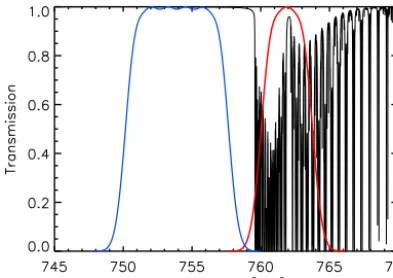
Figure 1. Spectral response functions for MERIS window channel 10 (blue) and MERIS channel 11 in the oxygen-A absorption band (red). Black lines: oxygen absorption lines.
at 753 nm and the oxygen-A absorption channel 11 centered at 761 nm, were used to simulate the ratio of the absorption channel over the window channel, shown in Fig. 1.
Radiative transfer simulations in a cloudy atmosphere are performed assuming a plane-parallel atmosphere with a ver-tical resolution of 20 hPa in the troposphere. The US Stan-dard Atmosphere model was assumed in the simulations (McClatchey et al., 1972). Furthermore, the surface is mod-eled as a Lambertian reflector with a surface albedo of 0.02 at visible wavelengths, a surface emissivity of 0.98 at thermal infrared wavelengths, and a surface pressure of 1013 hPa. A Rayleigh optical thickness of 0.026 is taken. To com-pute the absorption coefficients of the atmospheric gases, the k-distribution method is used (Bennartz and Fischer, 2000; Doppler et al., 2014b), in which the information on the posi-tion and width of absorpposi-tion lines is taken from the HITRAN database (Rothman et al., 2009).
In this sensitivity study, the cloud vertical distribution is described in the form of cloud vertical extinction profiles, since the entire shape of the cloud vertical profile, not only the vertical extent, can determine the mean in-cloud photon penetration depth. Note, for single-layer clouds, the CVE is equal to the CGT. Two types of cloud vertical extinction pro-files are assumed in the simulations. For the first type, 1 year of data from the combined CPR and MODIS product (2B-TAU, Polonsky et al., 2008) was analyzed. The clouds ob-served by CPR and MODIS were sorted with respect to their CTP and COT, resulting in nine different cloud types, us-ing the ISCCP cloud type classification (Rossow and Schif-fer, 1999). For each cloud type, the average vertical pro-file of extinction and the average vertical extent were de-termined. Since the vertical extent is fixed, no further as-sumption on the CGT in the forward model are needed for these profiles. More details on the resulting profiles and their incorporation into the FAME-C algorithm can be found in Henken et al. (2013) and Carbajal Henken et al. (2014). The derived normalized extinction profiles (from here on called
CPR-profiles/clouds) were then used in the MOMO radia-tive transfer simulations to generate look-up tables (LUTs) for each of the nine cloud types. The LUTs serve as for-ward models in the cloud height retrievals. For the second type, vertically homogeneous extinction profiles are assumed (from here on called HOM profiles/clouds). As an additional LUT dimension for the HOM clouds, each cloud is modeled with varying vertical extents, starting with a CGT of 20 hPa and ending at the maximum possible geometrical thickness.
For cloud layers below 440 hPa water droplets are as-sumed with a fixed effective radius of 10 µm. The single-scattering properties were computed using a Mie code (Wis-combe, 1980). For cloud layers above 440 hPa, ice crystals are assumed with a fixed effective radius of 40 µm, assuming single-scattering properties described in Baum et al. (2005).
For a number of CTP, CGT and COT combinations, the simulated results (MERIS radiance ratio and AATSR BT) at the top of the atmosphere (TOA) using CPR-profiles were compared to the simulated results using HOM profiles. A so-called equivalent HOM CTP is found by minimizing the difference between the TOA signal of the CPR-cloud with a specified CTP and the TOA signal of the HOM cloud for varying CTPs. The same total COT is used for both clouds. Figure 2 shows for both AATSR and MERIS the equiva-lent HOM CTPs for varying CGT and COT for the case of a CPR-cloud with CTP of 600 hPa. In general, the dif-ference between the equivalent HOM CTP and CPR CTP is smaller for AATSR than MERIS, especially for optically thick clouds. The largest difference between the equivalent HOM CTP and the CPR CTP is found for geometrically thin clouds with CGT=20 hPa and COT=10 for MERIS, while for AATSR the largest difference is found for optically thin clouds. The higher CTPs of the HOM clouds can be ex-plained by the fact that for clouds with the CPR-profiles, the extinction of the upper cloud layers is lower than the extinc-tion of the upper cloud layers for clouds with a HOM pro-file. In order to get the same TOA signal as the CPR-cloud, the HOM cloud needs to be placed at a lower altitude. Al-ternatively, the CGT of the HOM cloud can be increased. For both MERIS and AATSR, the HOM CTP approaches the CPR CTP for increasing CGT, and even underestimates the CTP for clouds extending down to the surface. Note that for the very optically thick clouds (COT=100), the HOM CTP does not reach the CPR CTP, even for vertically extended clouds. Missing points relate to CPR simulations results that did not fall within the range of HOM CTP results for the as-sumed CGT. For optically thick clouds, the dependence of the HOM CTP on the CGT is much weaker for AATSR than for MERIS, due to the fact that in the TIR the contribution from lower cloud layers to the TOA signal is weaker, and thus the shape of the entire cloud vertical extinction profile plays a less important role in the TIR than in the NIR.
vari-Figure 2. The equivalent HOM CTP for varying CGT and COT, assuming a CPR-cloud with CTP=600 hPa. Settings in the radiative transfer simulations: satellite viewing angle=0◦, solar viewing angle=35◦, relative azimuth angle=0◦, surface albedo=0.02 and MERIS central wavelength=762 nm.
Figure 3. The sensitivity of the equivalent MERIS and AATSR HOM CTP to an increase of CGT by 50 hPa. Cloud-top pressure of low cloud=800 hPa, middle cloud=600 hPa, and high cloud=300 hPa.
ous CTP and COT combinations. The sensitivity, which is the slope of each line in Fig. 2, was computed by simply applying a linear fit to each line that corresponds to a fixed COT and varying CGT. This was done for a low (800 hPa), mid-level (600 hPa), and high (300 hPa) cloud and a range of COTs. For MERIS, the sensitivity is largest for clouds with COT=10. This can be explained as follows. For optically thin clouds, a large part of the radiation arriving at TOA has traversed the cloud without interaction with cloud particles, thus not affected by the vertical extinction profile of the cloud at all. For optically very thick clouds, the contribution from upper cloud layers will dominate the TOA signal even for geometrically thicker clouds; thus the influence of the entire vertical extinction profile is smaller. For optically moderate thick clouds, the full vertical extinction profile has an impact on the TOA signal, while the contribution of the earth surface and the lower atmosphere is suppressed. For AATSR, the sensitivity decreases for increasing COT, indicating that the assumed shape of the extinction profile is of less importance for optically thick clouds due to contributions to the TOA signal arising mainly from upper cloud layers. In summary, the MERIS sensitivity is always higher than the AATSR sen-sitivity for COT > 5.
Figure 4 shows the AATSR sensitivity of the equivalent HOM CTP to the CGT for which the physical CTPs are
Figure 4. The sensitivity of the equivalent AATSR HOM CTP to an increase of CGT by 50 hPa. The pressure at 1 COT into the cloud is taken as corrected CTP. Cloud-top pressure of low cloud=800 hPa, middle cloud=600 hPa, and high cloud=300 hPa.
3 Data
3.1 AATSR and MERIS
Within FAME-C two independent cloud-top height products are retrieved on a pixel-basis: AATSR cloud-top temperature and MERIS cloud-top pressure. AATSR and MERIS are two passive imagers mounted on the polar-orbiting satellite En-visat, launched in March 2002 and operational until April 2012. Envisat flies in a sun-synchronous orbit with an equa-tor crossing time of 10:00 LT, descending node.
In the MERIS-CTP retrieval the transmission within the oxygen-A absorption band is estimated from the ratio of channel 11 and window channel 10. In the AATSR cloud-top temperature retrieval, brightness temperature measurements at 10.8 and 12 µm are used to retrieve cloud-top temperature. The forward model consists of three parts contributing to the TOA radiation: atmosphere, clouds and surface. The fast ra-diative transfer model RTTOV version 9.3 is used (Saunders et al., 2010; METOffice) to simulate clear-sky transmissions for the AATSR channels. Contributions from cloud layers and the surface to the TOA signal take into account the cloud and surface emissivities, respectively. Atmospheric profiles from a numerical weather model (NWP) reanalysis are used to convert cloud-top temperature and cloud-top pressure to cloud-top height. The cloud-top temperature is compared to the temperature profile and the minimum height at which the cloud-top temperature equals the atmospheric tempera-ture is assumed to be the cloud-top height. For optically thick clouds, CTT will be similar to the measured 10.8 µm bright-ness temperature, corrected for the atmosphere. For optically thin clouds, the cloud emissivity is taken into account, which will result in a CTT that is lower than the measured 10.8 µm brightness temperature. More information on the two inde-pendent cloud-top height retrievals can be found in Carba-jal Henken et al. (2014).
For this study, the FAME-C algorithm was extended to also provide retrieved cloud-top temperature from AATSR, top pressure from MERIS, and accompanying cloud-top heights, assuming a single-layer and vertically homoge-neous cloud with a geometrical thickness of 20 hPa. For op-tically thick clouds, this comes close to a solid reflector. Fur-ther adjustments in the FAME-C algorithm include the use of a new cloud masking method (Hollstein et al., 2015), which is in first order aimed to reproduce the former cloud mask-ing method but with higher computational efficiency. Before applying the cloud mask, the AATSR and MERIS measure-ments are collocated using the BEAM toolbox (Fomferra and Brockmann, 2005; ESA). In addition, the 3rd reprocessing for AATSR data were used and an empirical nonlinear cor-rection was applied to the 12 µm channel (Smith, 2014). Fur-ther, a stray light correction was performed for the MERIS measurements (Lindstrot et al., 2010a). Last, a pixel-based multi-layer cloud detection, i.e., thin cirrus over low-level water clouds, based on Pavolonis and Heidinger (2004) is im-plemented. Note, no distinct retrievals for multi-layer cloud cases are performed, the pixels are simply flagged as multi-layer cloud or not.
3.2 ARM millimeter cloud radar and micropulse lidar The active remote sensing of clouds (ARSCL) product from ground-based observations performed at the Atmospheric Radiation Measurement (ARM) program’s Southern Great Plains (SGP) site. In addition, three sites in the tropical west-ern Pacific (TWP) and one site in the North Slope borough of Alaska (NSA) are used, which cover different climatic regimes, surface conditions and allow varying sun-satellite viewing geometries. It provides cloud boundary heights, i.e., cloud-base height and cloud-top height, for up to 10 cloud layers (Clothiaux et al., 2000). The cloud boundary heights are determined from a combination of measurements from the Micropulse Lidar (MPL) and Millimeter Cloud Radar (MMCR) and are provided at a vertical resolution of 45 m and a temporal resolution of 10 s.
4 Method
To study the relationship between the difference in the two FAME-C cloud height retrievals and the cloud vertical extent as observed by ground-based lidar and radar instruments, the satellite and ground-based observations of clouds need to be matched accordingly.
For each ARM site the satellite orbit segments of all En-visat overpasses with available FAME-C level-2 cloud prop-erties for the years 2003–2011 are collected. The ground-based observations and satellite observations occur on dif-ferent spatial scales; thus temporal averaging for the AR-SCL products and spatial averaging for the FAME-C prod-ucts is performed. From the ARSCL data, the height of the top height of the highest cloud layer and the base height of the lowest cloud layer are collected for a 5-minute time pe-riod centered at the time of overflight of Envisat. The CVE is derived from the difference between the two extreme cloud boundaries. In addition, also the number of cloud layers and the distance between the cloud layers is extracted from the ARSCL data. From the FAME-C data, a 9×9 pixel box cen-tered at the center pixel was taken to compute mean vertical cloud-top heights. The pixel with the minimum distance to the location of the radar was selected as the center pixel. Us-ing the ARSCL cloud-top height and the satellite instrument viewing geometry, parallax correction is applied to adjust the center pixel. This was performed separately for AATSR CTT and MERIS CTP. The choice of the size of the pixel box for the FAME-C data and the time period of the ARSCL data is the result of pursuing a balance between the number of ob-servations available for appropriate statistics and the mean cloud properties being representative for the center obser-vation, taking into account that cloud properties can vary strongly in space and time.
In the evaluation, only cases with enough successfully re-trieved cloud height products within the satellite pixel box (> 80 %) and within the 5-minute time period (> 80 %) are selected. Successfully retrieved cloud height products are de-fined as the cloud-top heights of those satellite pixels for which the FAME-C cloud-top height retrieval converged suc-cessfully during the minimization of a retrieval cost function
J, which in turn is defined asJ< 20 within a maximum al-lowed number of iterations. For further information on tech-nical details of the FAME-C retrieval setup it is referred to Carbajal Henken et al. (2014). For the ARSCL products, at least 80 % of the time steps need to have a cloud-base height determined by the lidar and a cloud-top height either deter-mined by radar or lidar. In addition, the temporal and spatial variability should not be too large, i.e., the standard devia-tion of the selected cloud-top heights should be < 1 km. The selection criteria were chosen in such a way that the study is directed towards mainly overcast cloudy scenes with spa-tially and temporally uniform cloud-top heights, but still a large enough number of cases remain available. It results in a total of 153 selected cases, which is less than 6 % of all
En-visat overflights for which the AATSR swath passes over one of the ARM sites within the years 2003–2011. Note, both the ARSCL products, depending on the ARM site, and FAME-C products do not cover the full time period of the years 2003– 2011. There were 82, 24 and 47 valid cases found for the SGP, TWP and NSA ARM sites, respectively.
5 Results and Discussion
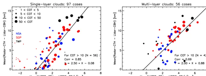
Figure 5 shows the results presented separately for single-layer and multi-single-layer clouds. Single-single-layer cloud cases are de-fined as cases where at least 80 % of the pixels in the satel-lite pixel box have not been identified as multi-layer clouds according to the multi-layer test implemented in FAME-C. Multi-layer cloud cases are defined as cases where at least 80 % of the pixels in the pixel box have been identified as multi-layer clouds.
One can immediately see that on average the difference in AATSR and MERIS CTHs (1CTH) increases with increas-ing CVE as observed by the radar and lidar. This is true for both single-layer and multi-layer clouds, though the corre-lation is higher for single-layer clouds. Most obvious out-liers mainly represent cases where the mean COT < 10. As one would expect from the climatic regimes, the most verti-cally extended clouds are found at the TWP sites, followed by the SGP site. The dependence of the1CTH on the CVE is strongest for the SGP site for optically thick clouds. There are several cases with optically thin clouds for which the MERIS CTH is higher than the AATSR CTH. One of the possible reasons for this is that the AATSR CTT might be incorrect due to incorrect assumptions in the forward model, which are related to estimates of the cloud emissivity and ig-noring multiple scattering. For single-layer low-level clouds, the derivation of the AATSR CTH might be ambiguous or missed if the temperature profile does not represent a tem-perature inversion accurately enough. This leads to a positive
Figure 5. Results of the comparison of mean cloud vertical extent derived from radar and lidar observations to the difference in mean cloud-top height retrieved with AATSR and MERIS.
which can be partly explained by considering that for these cloud cases, also a large part of the vertical column consists of cloud-free atmosphere. Here, the mean photon path length in the NIR is not increased due to in-cloud scattering. Thus, the effect of the cloud vertical distribution is suppressed rel-ative to vertically extended single-layer clouds. In the case of an optically thin, upper cloud layer, the AATSR CTH can fall towards the middle of the upper and lower cloud lay-ers, which possibly further weakens the relationship between
1CTH and CVE.
To demonstrate the difference in retrieved cloud-top height products assuming CPR cloud vertical profiles and HOM cloud vertical profiles, they were also individually compared to the radar-based CTHs. The results are listed in Table 1. AATSR CTH shows a negative bias. As expected, the dif-ference in biases between CPR and HOM, and also between single-layer and multi-layer clouds are small, since AATSR tends to see the upper cloud layers and therefore is less de-pendent on the cloud vertical extinction profile and vertical extent. For MERIS CTH, the difference in biases between CPR and HOM is large, with a small negative bias for CPR and a large negative bias for HOM. When only including cases where the mean COT > 5, the absolute biases decreases slightly for all except MERIS-CTH HOM. For AATSR CTH, the root mean square deviation (RMSD) of HOM and CPR show similar values and are smallest for single-layer clouds with COT > 5. The RMSD of MERIS-CTH HOM is larger than for MERIS-CTH CPR, and overall largest for multi-layer clouds.
6 Case study
The estimate of CVE from the relationship found in the for-mer section has been applied to Envisat observations of Hur-ricane Dean, which moved across the Caribbean Sea in Au-gust 2007. Hurricanes are dynamical cloud systems which consist of parts with dense and vertically extended clouds in the main part of the system, multi-layer clouds, optically
Table 1. Resulting biases and root mean square deviation (RMSD) from the comparison between the FAME-C cloud-top heights and radar/lidar derived cloud-top heights. Presented separately for single-layer clouds (Single) and multi-layer clouds (Multi) as well as for FAME-C cloud-top heights retrieved using 1 homogeneous cloud layer (HOM) and the CPR vertical cloud profiles (CPRs). Re-sults are also shown for clouds with a mean cloud optical thickness larger than 5.
Bias [km] RMSD [km] Single Multi Single Multi
AATSR CTH CPR −0.88 −1.58 2.38 2.89
HOM −1.20 −1.58 2.63 2.89
MERIS CTH CPR −0.27 −1.76 2.51 4.03
HOM −2.44 −4.50 3.57 5.44 AATSR CTH, COT > 5 CPR −0.56 −1.55 1.99 2.86 HOM −0.62 −1.56 1.98 2.83 MERIS CTH, COT > 5 CPR −0.22 −1.71 2.57 3.99 HOM −2.71 −4.42 3.81 5.38
thick and thin cirrus clouds, and single-layer low-level clouds at the outer regions of the system.
Figure 6. View on hurricane Dean on 17 August 2007. Top left: color composite from MERIS bands 2, 3, and 4. Top right: FAME-C multi-layer cloud flag. Bottom left: retrieved AATSR cloud-top height. Bottom right: estimated cloud vertical extent. The solid black line and the dotted red line show the AATSR-MERIS and CloudSat cross section, respectively, as presented in Fig. 7. Note, the CloudSat overpass occurred about 3 hours later than the AATSR-MERIS observations presented here.
Figure 7. Cross section of hurricane Dean (17 August 2007). Top: estimated cloud vertical extent from FAME-C cloud heights. Bot-tom: radar reflectivity from CPR on CloudSat. The blue dots show the height of the most upper layer identified as cloud by the CPR cloud mask (> 30). Note, cross sections from the Envisat and Cloud-Sat overpasses did not collocate in space and time.
The vertical extent is estimated to be up to 15 km for the main part of the hurricane, which agrees well with the max-imum height as observed by CPR. The maxmax-imum estimated
esti-mated CVE is well below the distance between the two cloud layers.
7 Conclusions
This study presents the evaluation of differences between two cloud height retrievals that are based on independent tech-niques, and relating the differences to cloud vertical extent (CVE) as observed by ground-based active instruments. The CVE is an additional parameter to the cloud-top height, both parameters describing the cloud vertical distribution. Mea-surements from the passive imagers AATSR and MERIS on board the polar-orbiting satellite Envisat were used in the FAME-C algorithm. Cloud-top temperature is retrieved us-ing brightness temperature measurements from two AATSR thermal infrared (TIR) channels, while cloud-top pressure (CTP) is retrieved with the use of the ratio of the MERIS channel in the oxygen-A absorption band and a nearby win-dow channel.
Due to larger mean in-cloud photon penetration depths for shortwave radiation than for longwave radiation, the sensi-tivity of the latter retrieval (in the near-infrared) to the cloud vertical extinction profile is larger than for the former re-trieval (in the TIR). This was shown in a sensitivity study in which simulation results from the radiative transfer model MOMO for homogeneous and inhomogeneous cloud verti-cal extinction profiles are compared for both simulations, us-ing MERIS and AATSR spectral response functions. The in-homogeneous profiles are derived from combined CloudSat-CPR and MODIS data. The equivalent CTP of the homoge-neous (HOM) clouds with specified cloud geometrical thick-ness (CGT) was obtained by comparing and minimizing the simulated top-of-atmosphere signals of the “more realistic” CPR-clouds with the ones from the HOM clouds. The results confirm that in general, the MERIS equivalent HOM CTP is more sensitive to a change in the CGT than AATSR. For both AATSR and MERIS simulations, this sensitivity decreases for increasing cloud optical thickness (COT).
The differences between the MERIS CTP and AATSR CTT, both converted to CTH using atmospheric profiles from a numerical weather prediction model, 1CTH, were com-pared to the CVE. In the MERIS-CTP retrieval a single-layer, vertically homogeneous and geometrically thin cloud was as-sumed to suppress the correction for multi-scattering in the cloud. This was done to increase the impact of the CVE on
1CTH. The extent is defined as the distance between the top height of the highest cloud layer and the base height of the lowest cloud layer. These cloud boundaries are extracted from the ARSCL cloud product based on ground-based radar and lidar observations. It was shown that 1CTH increases with increasing CVE for both single-layer and multi-layer clouds, though the relation appears stronger for single-layer clouds. Applying a linear fit to the results with COT > 10 in-dicates that a rough estimate of the CVE can be obtained
by multiplying1CTH by a factor of 2.5. If we assume that AATSR CTH is close to but a bit lower than the physical cloud top, this was indicated by a small negative bias com-pared to radar CTH, than the MERIS CTH is close to the geometrical center of the cloud. Similar findings were found in other studies related to oxygen-A absorption band-based cloud pressure retrievals. The uncertainty in the CTH re-trievals, the large variability in cloud vertical extinction pro-files occurring in nature and the use of only one measurement in the oxygen-A absorption band limits the accuracy of CVE estimates. However, by using a simple linear relationship a rough estimate of the CVE can be made allowing for at least a qualitative interpretation of a cloudy scene. An estimate of CVE is automatically an estimate of the cloud-base height of the lower cloud layer. As a further demonstration of the plau-sibility of the approach, estimates of the CVE for a cloudy scene were performed within a case study.
In the comparison of the FAME-C1CTH to observations of CVE from ground-based instruments, a limited number of cases was exploited mainly due to filtering out observations of inhomogeneous cloud fields in space and time. Compar-isons to observations of CVE from CPR on CloudSat and CALIOP on CALIPSO can be performed next. However, matching overpasses of Envisat and A-train only occurred at high latitudes for which CTH retrievals are complicated due to snow/ice surfaces and large solar zenith angles. Moreover, the different satellite viewing geometries in the presence of inhomogeneous cloud fields complicate the matching of En-visat and A-train observations.
The impact of future improvements/updates in the FAME-C algorithm on the cloud height retrievals will be investi-gated. Such changes will include an updated version of RT-TOV (and coefficient files) and HITRAN database as well as an improved cloud phase detection and a new cloud masking method.
Acknowledgements. The authors would like to thank ESA for providing the funding for this study within the frame of the ESA CCI Cloud project as well as the Bundesministerium für Bildung und Forschung for providing funding in the framework of the HD(CP)2project. Also, the authors would like to thank the ARM Program Climate Research Facility for providing the ARSCL data.
Edited by: A. Kokhanovsky
References
Baum, B. A., Yang, P., Heymsfield, A. J., Platnick, S., King, M. D., Hu, Y., and Bedka, S. T.: Bulk scattering properties for the re-mote sensing of ice clouds. Part II: Narrowband models, J. Appl. Meteorol., 44, 1896–1911, 2005.
Bennartz, R. and Fischer, J.: A modifiedk-distribution approach ap-plied to narrow band water vapour and oxygen absorption esti-mates in the near infrared, J. Quant. Spectrosc. Ra., 66, 539–553, 2000.
Carbajal Henken, C. K., Lindstrot, R., Preusker, R., and Fischer, J.: FAME-C: cloud property retrieval using synergistic AATSR and MERIS observations, Atmos. Meas. Tech., 7, 3873–3890, doi:10.5194/amt-7-3873-2014, 2014.
Clothiaux, E. E., Ackerman, T. P., Mace, G. G., Moran, K. P., Marc-hand, R. T., Miller, M. A., and Martner, B. E.: Objective deter-mination of cloud heights and radar reflectivities using a combi-nation of active remote sensors at the ARM CART sites, J. Appl. Meteorol., 39, 645–665, 2000.
Desmons, M., Ferlay, N., Parol, F., Mcharek, L., and Vanbauce, C.: Improved information about the vertical location and extent of monolayer clouds from POLDER3 measurements in the oxygen A-band, Atmos. Meas. Tech., 6, 2221–2238, doi:10.5194/amt-6-2221-2013, 2013.
Doppler, L., Carbajal-Henken, C., Pelon, J., Ravetta, F., and Fischer, J.: Extension of radiative transfer code MOMO, matrix-operator model to the thermal infrared–Clear air validation by comparison to RTTOV and application to CALIPSO-IIR, J. Quant. Spectrosc. Ra., 144, 49–67, 2014a.
Doppler, L., Preusker, R., Bennartz, R., and Fischer, J.: bin and k-IR: k-distribution methods without correlation approximation for non-fixed instrument response function and extension to the ther-mal infrared Applications to satellite remote sensing, J. Quant. Spectrosc. Ra., 133, 382–395, 2014b.
ESA: BEAM Earth Observation Toolbox and Development Plat-form, available at: http://www.brockmann-consult.de/cms/web/ beam, last access: May 2014.
Fell, F. and Fischer, J.: Numerical simulation of the light field in the atmosphere–ocean system using the matrix-operator method, J. Quant. Spectrosc. Ra., 69, 351–388, 2001.
Ferlay, N., Thieuleux, F., Cornet, C., Davis, A. B., Dubuisson, P., Ducos, F., Parol, F., Riédi, J., and Vanbauce, C.: Toward new inferences about cloud structures from multidirectional measure-ments in the oxygen A band: Middle-of-cloud pressure and cloud geometrical thickness from POLDER-3/PARASOL, J. Appl. Meteorol. Clim., 49, 2492–2507, 2010.
Fischer, J. and Grassl, H.: Detection of cloud-top height from backscattered radiances within the oxygen A band. Part 1: Theo-retical study, J. Appl. Meteorol., 30, 1245–1259, 1991.
Fomferra, N. and Brockmann, C.: Beam-the ENVISAT MERIS and AATSR toolbox, in: MERIS (A) ATSR Workshop 2005, vol. 597, p. 13, 2005.
Hamann, U., Walther, A., Baum, B., Bennartz, R., Bugliaro, L., Derrien, M., Francis, P. N., Heidinger, A., Joro, S., Kniffka, A., Le Gléau, H., Lockhoff, M., Lutz, H.-J., Meirink, J. F., Minnis, P., Palikonda, R., Roebeling, R., Thoss, A., Platnick, S., Watts, P., and Wind, G.: Remote sensing of cloud top pressure/height from SEVIRI: analysis of ten current retrieval algorithms, At-mos. Meas. Tech., 7, 2839–2867, doi:10.5194/amt-7-2839-2014, 2014.
Henken, C. C., Lindstrot, R., Filipitsch, F., Walther, A., Preusker, R., and Fischer, J.: FAME-C: Retrieval of cloud top pressure with vertically inhomogeneous cloud profiles, in: AIP Confer-ence Proceedings, vol. 1531, p. 412, 2013.
Hollstein, A. and Fischer, J.: Radiative transfer solutions for cou-pled atmosphere ocean systems using the matrix operator tech-nique, J. Quant. Spectrosc. Ra., 113, 536–548, 2012.
Hollstein, A., Fischer, J., Carbajal Henken, C., and Preusker, R.: Bayesian cloud detection for MERIS, AATSR, and their combi-nation, Atmos. Meas. Tech., 8, 1757–1771, doi:10.5194/amt-8-1757-2015, 2015.
Hollmann, R., Merchant, C., Saunders, R., Downy, C., Buchwitz, M., Cazenave, A., Chuvieco, E., Defourny, P., De Leeuw, G., Forsberg, R., Holzer-Popp, T., Paul, F., Sandven, S., Sathyen-dranath, S., van Roozendael, M., and Wagner, W.: The ESA cli-mate change initiative: Satellite data records for essential clicli-mate variables, B. Am. Meteorol. Soc., 94, 1541–1552, 2013. Koelemeijer, R., Stammes, P., Hovenier, J., and De Haan, J.: Global
distributions of effective cloud fraction and cloud top pressure derived from oxygen A band spectra measured by the Global Ozone Monitoring Experiment: comparison to ISCCP data, J. Geophys. Res.-Atmos., 107, AAC 5-1–AAC 5-9, 2002. Kokhanovsky, A. A. and Rozanov, V. V.: Cloud bottom altitude
de-termination from a satellite, IEEE Geosci. Remote S., 2, 280, 2005.
Korpela, A., Dybbroe, A., and Thoss, A.: Retrieving Cloud Top Temperature and Height in Semi-transparent and fractional cloudiness using AVHRR, Reports Meteorologi 100, SMHI, Nor-rköping, Sweden. NWCSAF Visiting Scientist Report, 35 pp., 2001.
Li, Y., Thompson, D. W., Stephens, G. L., and Bony, S.: A global survey of the instantaneous linkages between cloud vertical structure and large-scale climate, J. Geophys. Res.-Atmos., 119, 3770–3792, 2014.
Lindstrot, R., Preusker, R., and Fischer, J.: Empirical Correction of Stray Light within the MERIS Oxygen A-Band Channel, J. Atmos. Ocean. Tech., 27, 1185–1194, 2010a.
Lindstrot, R., Preusker, R., and Fischer, J.: Remote Sensing of Mul-tilayer Cloud-Top Pressure Using Combined Measurements of MERIS and AATSR on board Envisat, J. Appl. Meteorol. Clim., 49, 1191–1204, 2010b.
Luo, Y., Zhang, R., and Wang, H.: Comparing occurrences and ver-tical structures of hydrometeors between eastern China and the Indian monsoon region using CloudSat/CALIPSO data, J. Cli-mate, 22, 1052–1064, 2009.
obser-vations from summer 2006, Geophys. Res. Lett., 34, L09808, doi:10.1029/2006GL029017, 2007.
McClatchey, R. A., Fenn, R., Selby, J. A., Volz, F., and Garing, J.: Optical properties of the atmosphere, Rep. AFCRL-72-0497, Air Force Cambridge Research Lab., Bedford, Mass., 85 pp., 1972. Menzel, W. P., Frey, R. A., Zhang, H., Wylie, D. P., Moeller, C. C.,
Holz, R. E., Maddux, B., Baum, B. A., Strabala, K. I., and Gum-ley, L. E.: MODIS global cloud-top pressure and amount estima-tion: Algorithm description and results, J. Appl. Meteorol. Clim., 47, 1175–1198, 2008.
METOffice: RTTOV v9, available at: http://research.metoffice. gov.uk/research/interproj/nwpsaf/rtm/rtm_rttov9.html, last ac-cess: May 2014.
Moroney, C., Davies, R., and Muller, J.-P.: Operational retrieval of cloud-top heights using MISR data, IEEE T. Geosci. Remote, 40, 1532–1540, 2002.
Naud, C. M., Muller, J.-P., Clothiaux, E. E., Baum, B. A., and Menzel, W. P.: Intercomparison of multiple years of MODIS, MISR and radar cloud-top heights, Ann. Geophys., 23, 2415– 2424, doi:10.5194/angeo-23-2415-2005, 2005.
Naud, C. M., Del Genio, A. D., Bauer, M., and Kovari, W.: Cloud vertical distribution across warm and cold fronts in CloudSat-CALIPSO data and a general circulation model, J. Climate, 23, 3397–3415, 2010.
Pavolonis, M. J. and Heidinger, A. K.: Daytime cloud overlap detec-tion from AVHRR and VIIRS, J. Appl. Meteorol., 43, 762–778, 2004.
Polonsky, I., Labonnote, L., and Cooper, S.: Level 2 cloud opti-cal depth product process description and interface control docu-ment, CloudSat Project, NASA Earth System Science Pathfinder Mission, Institute for Research in the Atmosphere, Colorado State University 21 pp., 2008.
Preusker, R. and Lindstrot, R.: Remote Sensing of Cloud-Top Pres-sure Using Moderately Resolved MeaPres-surements within the Oxy-gen A Band-A Sensitivity Study, J. Appl. Meteorol. Clim., 48, 1562–1574, 2009.
Rossow, W. B. and Schiffer, R. A.: Advances in understanding clouds from ISCCP, B. Am. Meteorol. Soc., 80, 2261–2287, 1999.
Rothman, L. S., Gordon, I. E., Barbe, A., Benner, D. C., Bernath, P. F., Birk, M., Boudon, V., Brown, L. R., Campargue, A., Cham-pion, J.-P., Chance, K., Coudert, L. H., Dana, V., Devi, V. M., Fally, S., Flaud, J.-M., Gamache, R. R., Goldman, A., Jacque-mart, D., Kleiner, I., Lacome, N., Lafferty, W. J., Mandin, J.-Y., Massie, S. T., Mikhailenko, S. N., Miller, C. E., Moazzen-Ahmadi, N., Naumenko, O. V., Nikitin, A. V., Orphal, J., Perevalov, V. I., Perrin, A., Predoi-Cross, A., Rinsland, C. P., Rot-ger, M.,Šimeˇcková, M., Smith, M. A. H., Sung, K., Tashkun, S. A., Tennyson, J., Toth, R. A., Vandaele, A. C., and Vander Auw-era, J.: The HITRAN 2008 molecular spectroscopic database, J. Quant. Spectrosc. Ra., 110, 533–572, 2009.
Rozanov, V. V. and Kokhanovsky, A. A.: Semianalytical cloud re-trieval algorithm as applied to the cloud top altitude and the cloud geometrical thickness determination from top-of-atmosphere re-flectance measurements in the oxygen A band, J. Geophys. Res.-Atmos., 109, D05202, doi:10.1029/2003JD004104, 2004. Saiedy, F., Hilleary, D., and Morgan, W.: Cloud-top altitude
mea-surements from satellites, Appl. Optics, 4, 495–500, 1965.
Saiedy, F., Jacobowitz, H., and Wark, D.: On cloud-top determina-tion from Gemini-5, J. Atmos. Sci., 24, 63–69, 1967.
Sassen, K., Wang, Z., and Liu, D.: Global distribution of cirrus clouds from CloudSat/Cloud-Aerosol lidar and infrared pathfinder satellite observations (CALIPSO) measurements, J. Geophys. Res.-Atmos., 113, D00A12, doi:10.1029/2008JD009972, 2008.
Saunders, R., Matricardi, M., and Geer, A.: RTTOV-9 Users Guide, NWP SAF Rep. NWPSAF-MO-UD-016, User guide, Met Of-fice, 2010.
Sherwood, S. C., Chae, J.-H., Minnis, P., and McGill, M.: Under-estimation of deep convective cloud tops by thermal imagery, Geophys. Res. Lett., 31, L11102, doi:10.1029/2004GL019699, 2004.
Smith, D.: Empirical Nonlinearity Correction for 12um Channel, Tech. rep., RAL Space AATSR Technical note, Doc No: PO-TN-RAL-AT-0562, Issue: 1.1, 2014.
Stephens, G. L., Vane, D. G., Boain, R. J., Mace, G. G., Sassen, K., Wang, Z., Illingworth, A. J., O’Connor, E. J., Rossow, W. B., Durden, S. L., Miller, S. D., Austin, R. T., Benedetti, A., Mitrescu, C., and the CloudSat Science Team: The Cloud-Sat mission and the A-Train: A new dimension of space-based observations of clouds and precipitation, B. Am. Meteorol. Soc., 83, 1771–1790, 2002.
Vanbauce, C., Buriez, J.-C., Parol, F., Bonnel, B., Seze, G., and Couvert, P.: Apparent pressure derived from ADEOS-POLDER observations in the oxygen A-band over ocean, Geophys. Res. Lett., 25, 3159–3162, 1998.
Vanbauce, C., Cadet, B., and Marchand, R. T.: Compari-son of POLDER apparent and corrected oxygen pressure to ARM/MMCR cloud boundary pressures, Geophys. Res. Lett., 30, 1212, , doi:10.1029/2002GL016449, 2003.
Wang, J. and Rossow, W. B.: Effects of cloud vertical structure on atmospheric circulation in the GISS GCM, J. Climate, 11, 3010– 3029, 1998.
Wang, P., Stammes, P., van der A, R., Pinardi, G., and van Roozen-dael, M.: FRESCO+: an improved O2A-band cloud retrieval algorithm for tropospheric trace gas retrievals, Atmos. Chem. Phys., 8, 6565–6576, doi:10.5194/acp-8-6565-2008, 2008. Weisz, E., Li, J., Menzel, W. P., Heidinger, A. K., Kahn, B. H.,
and Liu, C.-Y.: Comparison of AIRS, MODIS, CloudSat and CALIPSO cloud top height retrievals, Geophys. Res. Lett., 34, L17811, doi:10.1029/2007GL030676, 2007.
Winker, D. M., Pelon, J. R., and McCormick, M. P.: The CALIPSO mission: Spaceborne lidar for observation of aerosols and clouds, in: Third International Asia-Pacific Environmental Remote Sens-ing Remote SensSens-ing of the Atmosphere, Ocean, Environment, and Space, 1–11, International Society for Optics and Photonics, 2003.
Wiscombe, W. J.: Improved Mie scattering algorithms, Appl. Op-tics, 19, 1505–1509, 1980.
Yamamoto, G. and Wark, D.: Discussion of the letter by RA Hanel,“Determination of cloud altitude from a satellite”, J. Geo-phys. Res., 66, 3596–3596, 1961.
Yin, J., Wang, D., Zhai, G., and Wang, Z.: Observational charac-teristics of cloud vertical profiles over the continent of East Asia from the CloudSat data, Acta Meteorol. Sin., 27, 26–39, 2013.