http://www.sciencepublishinggroup.com/j/ijec doi: 10.11648/j.ijec.20190301.14
ISSN: 2640-1452 (Print); ISSN: 2640-1460 (Online)
Gold Mining Activities on Surrounding Soils of Kombo
Laka in Adamaoua Region-Cameroon
Nchare Mominou
1, *, Hamadou Dio
1, Kah Elvis
2, Badohok Sarki
11
Department of Mining Engineering, School of Geology & Mining Engineering, University of Ngaoundere, Ngaoundéré, Cameroon
2Department of Geomatic and Cartography, School of Geology & Mining Engineering, University of Ngaoundere, Ngaoundéré, Cameroon
Email address:
*
Corresponding author
To cite this article:
Nchare Mominou, Hamadou Dio, Kah Elvis, Badohok Sarki. Gold Mining Activities on Surrounding Soils of Kombo Laka in Adamaoua Region-Cameroon. International Journal of Environmental Chemistry. Vol. 3, No. 1, 2019, pp. 24-29. doi: 10.11648/j.ijec.20190301.14
Received: March 7, 2019; Accepted: April 15, 2019; Published: May 20, 2019
Abstract:
Heavy metal pollution is one of the most important problems in mining industry, causing serious effects to humans and animals. The present study evaluates the spatial distribution of heavy metals in Kombo Laka mine area in Mbere subdivision, and evaluates the characteristics of the pollution generated by mining activities in this locality. A total of 24 soil samples were collected from Adamsi, Benou, Abattoir and Wantia mining sites along with two control soil samples. Parameters such as pH, electrical conductivity and carbonate content were measured according to standard methods, while heavy metals concentration in different samples was determined fluorescence x(XRF). Coarse sand (2.0-1.0 mm) and fine sand (0.250-0.125 mm) were the dominant fractions of all soils samples, ranging from 28.3 to 24.2 and 25.4 to 23.2% in Abatoir and Adamsi soils respectively. At the same time, silty clay (<0.031 mm) was the dominant fraction ranging from 20.3 to 24.9%. The pollution load index (PLI) was calculated to evaluate the degree of contamination. The results of PLI for the selected elements confirm anthropogenic action in the area since all values are > 1. Contamination factors (CF) and pollution index (IP) were calculated for Arsenic (As), Copper (Cu), Lead (Pb) and Zinc (Zn), in order to estimate the anthropogenic contribution of these elements in the pollution of this locality. The results show that the area is polluted and measures need to be taken for remediation.Keywords: Heavy Metals, Contamination, Pollution Index, Kombolaka, Cameroon
1. Introduction
Metallic trace elements (MTE) are natural elements characterized by high density, greater than 5g/cm3. Currently in nature, 41 metals and 5 metalloids are identified [1]. Heavy metals are elements with atomic weights between 63.5 and 200.6 and a density greater than 5.0g/cm3 [2]. Unlike most organic contaminants, heavy metals are naturally occurring constituents in rocks and mineral deposits. These elements are normally present at low levels (trace levels, less than 0.1%) in soils, sediments, surface waters and living organisms. Heavy metals are released into the environment, either by natural processes (weathering), or anthropogenic processes (mining). There are certain characteristics common to all heavy metals which make them dangerous for living systems [3]; they are toxic within tolerance limits. Today mining is a vital part of the Global economy; the extraction
Soil is a complex and dynamic system, constituted by several layers that differ in relation to the physical, chemical, mineralogical and biological nature. Soil plays an important role in protecting the groundwater acting as a collector filter of organic and inorganic residues, helping in sequestering possible toxic compounds [8]. Excess heavy metal accumulation in soils and water is toxic to humans and other animals. Artisanal and small scale mining are more common activities today in Cameroon, impacting negatively the environment. In our previous study [9], we reported the physicochemical characterization of soils at the gold exploitation sites of Bétaré-Oya District in Cameroon and pollution evaluation. Analysis of Bétaré-Oya gold mining sites revealed a contamination by heavy metals at all primary gold mining sites, presenting a risk of release and migration of heavy metals if there is any slight change in environmental
conditions.
This Issue aims to study heavy metal accumulation in soil and pollution evaluation of the gold exploitation site of Kombo Laka, Adamaoua Region in Cameroon.
2. Materials and Methods
2.1. Site Description
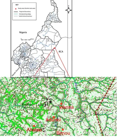
The gold district of Kombo-Laka is located about 130km on the axis Meiganga-Batoua-Godolé. This district covers an area of approximately 90km2. Kombo-Laka is a site of artisanal and semi-mechanized gold exploitation known under the name of "Chantier Fel". The studied area is shown in figure 1.
2.2. Geological Context [10]
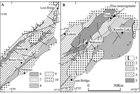
The series has a monoclinal structure, rich in shale and sandstone with intercalations of quartzitic lenses having a conglomeratic level at the base. The geological map of the study area is presented in figure 2.
Figure 2. Geological map of the Lower and Upper Lom series.
(1) hornfels, (2) pan-African granites, (3) micro conglomerate chloritoschists, (4) schistsfelsicvolcaniclastic, (5) quartz micaschists, (6) graphiticschists, (7) quartzites, (8) staurolite mica schists, (9) biotite gneiss, (10) S-type foliated granite.
2.2. Materials
Global Positioning System (GPS) was used to locate the sampling point. Fluorescence X (XRF) was used to conduct chemical analysis by mean of Genius 7000 XRF; a column of Sieves for granulometric analysis.
2.3. Sampling Method
Stratified random sampling was used in this study [11], it is a strategy based not only on a statistical approach [12], but where, in addition, the studied area is divided into homogeneous entities, called strata 4 sites were sampled namely: Abattoir (artisanal mining site), Adamsi (semi-mechanized exploitation site), Benou(abandoned mining site and Wantia (artisanal and semi-mechanized exploitation site).
2.4. Samples Analysis
Soil samples were dried and passed through a 2-mm sieve. The concentrations of As, Cu, Pb and Zn were determined by means of XRF. Soil pH was measured in soil-H2O suspension
(1:2.5, w/w) and organic matter content was determined by the Walkley and Black procedure [13]. Soil samples were dried at 60°C for 72h; then each sample was crushed, sieved
(< 325µm), homogenized, and weighed. Soil particle size distribution was measured using the hydrometer method [14].
2.5. Assessment of Potential Environmental Risk
In order to evaluate the quality of soils, a significant number of indicators were used [15-17]. In this study the assessment of soils contamination level was performed by the quantification of the contamination factor (CF) and the pollution load index (PLI).
For each soil sample and each heavy metal the CF has been calculated as the ratio between the metal concentrations with its background values as expressed by (1).
CF = Cheav metal/ C background (1)
CF < 1 indicates low contamination; 1 < CF < 3 is moderate contamination; 3 < CF < 6 is considerable contamination and CF > 6 is very high contamination [13].
For the entire sampling site, PLI has been determined as the nth root of the product of the n CF as indicate in relation (2):
3. Results and Discussion
3.1. Mean Values (%) of the Grain Size Distribution of Different Soils from Kombo Laka Area
Textural characteristics of the studied soils are shown in Table 1 according to the classification of Shepard and Moore [18].
Table 1. Mean values (%) of the grain size distribution of different soils from kombo laka area.
Soil Abatoir Adamsi Benou Wantia Control Soil
Clay 20.3 ± 2.2 24.9± 3.0 24.2± 1.3 25.2±2.1 26.4±2.5
Fine silt 17.1±1.8 16.4±2.6 25.9±2.2 25.7±1.4 30.5±3.7
Coarse silt 9.1±1.3 8.6±1.4 25.5±1.3 24.3±1.5 19.8±1.2
Fine sand 25.4±2.8 23.2±3.2 14.7±4.3 15.6±2.7 6.2±0.7
Coarse sand 28.3±2.3 24.2±2.1 8.2±2.1 15.4±1.7 6.1±0.4
From the table we can see that coarse sand (2.0-1.0 mm) and fine sand (0.250-0.125 mm) were the dominant fractions of all soils samples, ranging from 28.3 to 24.2 and 25.4 to 23.2% in Abatoir and Adamsi soils respectively. At the same time, silty clay (<0.031 mm) was the dominant fraction ranging from 20.3 to 24.9%.
3.2. Geochemical Characteristics of Different Soils Samples
Carbonate content, organic carbon content (OCC), pH, and organic matter (Table 2) are geochemical soil characteristics able to provide sufficient information to understand the soils capacity to retain heavy metal pollutants [19].
Table 2. Geochemical characteristics of different soils samples.
Parameter Abatoir Adamsi Benou Wantia Control Soil
PH 7.02 6.13 5.6 7.9 7.8±0.2
OM (%) 4.7 ±1.0 6.1±0.5 7.1±0.7 5.3±1.2 4.2±0.2
OCC (%) 2.2±0.3 4.1±0.2 3.8±0.9 3.3±0.3 2.5±0.5
Results from table 2, revealed that, in general, samples from Abatoir and Wantia showed a neutral to alkaline pH ranging from 7.02 to 7.9 similar to control samples. Low pH values in Adamsi and Benou samples were related with heterogeneous sulphidic residues deposits, which cause a decrease of the pH by sulphide oxidation and of sulfuric acid formation. Among the factors influencing the accumulation of nutrients, particle size played a significant role. Fine grained soils often show higher concentrations of nutrients due to their greater surface-to-volume ratio and enrichment of organic matter (OM) [20]. Mean OM contents in studied soils were in the range of 4.7% to 5.3% dry weight in Abatoir and Wantia; 6.1% and 7.1% dry weight in Adamsi and Benou soil samples. These results show that anthropogenic contribution from domestic sewage
discharge at Kombo Laka region was an important source of OM to this mining area. High values of OM content were due to agricultural activities around the area. The organic carbon content (OCC) ranged from 2.2% to 3.8% in Abatoir, Benou and Wantia samples. It reached 4.1% in Adamsi samples, reflecting a corresponding decrease of the soil grain size. The highest organic carbon contents occurred at the soils that had the lowest sand contents and the highest silt and clay contents.
3.3. Mean Concentrations of Heavy Metals in Different Soil Samples from Kombo Laka
Table 3 shows the mean concentration of As, Cu, Pb and Zn in soils of Kombo Laka.
Table 3. Mean concentrations of heavy metals in different soil samples from Kombo Laka.
Metal (mg/Kg) Abatoir Adamsi Benou Wantia Control Soil
As 56.4±12.3 76.4±12.2 48.6±4/3 53.4±2.1 17.3±4.3
Cu 24.4±4.3 20.3±8.8 38.9±2.3 28.8±4.5 21.3±6.4
Pb 120.5±11.2 198.7±18.7 145.7±3/2 138.7±6.9 11.3±1.4
Zn 203.4±9.3 212.3±10.7 191.2±3.2 201.3±3.5 32.9±2.0
The concentrations of heavy metals were higher in Adamsi soil. Heavy metal concentrations in these soils are strongly determined by local geology or anthropogenic influences. The weathering of minerals is one of the major natural sources, while anthropogenic sources are related to the use of fertilizers, irrigation and industrial effluent from mining activities [21]. In this area, mining extract activities are likely to be the major contamination sources. Total As showed higher concentrations in Adamsi with 76.5 ± 12.2 mg/Kg. Total Zn also showed similar trends with highest level at the
same soils with 212.3 ± 10.1 mg/kg. Compared to the control soil (CS), the contents of other metallic elements show a significant increase.
3.4. Contamination Factors (CF) and Pollution Load Index of Different Soils in Kombo Laka Region
The contamination factors (CF) calculated as indicated in the experimental section is found in table 4, and show the extent of contamination processes in each location.
CF of analyzed metals [22, 23], and it allows an assessment of the degree of polymetallic pollution of analyzed soil samples. Value greater than 1, indicates that the analyzed sample had a metallic contamination caused by human
activities. The pollution load index (Table 4) shows that all soil samples are highly contaminated with metals since PLI values are above the legal pollution load index that is equal to 1, with values ranging from 3.8 and 8.6.
Table 4. Contamination factors (CF) and pollution load index(PLI) of different soils.
Samples CF PLI
As Cu Pb Zn
Abatoir 0.75 0.35 6.12 0.26 1.0
Adamsi 0.82 0.12 4.81 0.08 1.9
Benou 0.92 0.25 3.15 0.15 4.6
Wantia 1.20 0.18 4.7 0.22 1.1
Upper Continental Crust 3.25 2 18 0.20
The pollution load index (PLI) was calculated to evaluate the degree of contamination. The results of PLI for the selected elements confirm anthropogenic action in the area since all values are > 1.
4. Conclusion
After this study, it should be noted that coarse sand (2.0-1.0 mm) and fine sand (0.250-0.125 mm) were the dominant fractions of all soils samples, ranging from 28.3 to 24.2 and 25.4 to 23.2% in Abatoir and Adamsi soils respectively. At the same time, silty clay (<0.031 mm) was the dominant fraction ranging from 20.3 to 24.9%. Samples from Abatoir and Wantia showed a neutral to alkaline pH ranging from 7.02 to 7.9 similar to control samples. Mean organic mattercontents in studied soils were in the range of 4.7% to 5.3% dry weight in Abatoir and Wantia; 6.1% and 7.1% dry weight in Adamsi and Benou soil samples; showing that anthropogenic contribution from domestic sewage discharge at Kombo Laka region was an important source of organic matter to this mining area. High values of organic matter content were due to agricultural activities around the area. Mining activities are likely to be the major contamination sources. Total As showed higher concentrations in Adamsi with 76.5 ± 12.2 mg/Kg. Total Zn also showed similar trends with highest level at the same soils with 212.3 ± 10.1 mg/kg. The pollution index shows that all soil samples are highly contaminated with metals since PI values are above the legal pollution load index that is equal to 1, with values ranging from 3.8 and 8.6. This contamination is expressed by high contamination factor and PLI values. These results reflect an enrichment of elements of anthropic origin in comparison with average levels in the Upper Continental Crust. Lead(Pb) enrichment would be linked to mining activity whereas Arsenic(As) would be derived from other human activities. Understanding the degree, scale, and sources of heavy metal contamination is essential for environmental management. It is also important in reducing risks to human health, ensuring food safety, and managing contaminated soil.
References
[1] Olivier A. «Chimie et pollution des eaux souterraines», Tec et DocLavoisierEdition. 2005.
[2] Srivastava N. K., Majumder C. B. Novel biofiltration methods for the treatment of heavy metals from industrial wastewater, J. Hazard. Mater. 2008, 151, 1-8
[3] Dinetto, M. Dossier SAM –«les métaux lourds» Ecole Nationale Supérieure des Mines de Saint Etienne. 1997, p 201. [4] Song Y, Ji J, Mao C, Yang Z, Yuan X, Ayoko GA, Fros RL. Heavy metal contamination in suspended soils of Changjiang River – environmental implications. Geoderma. 2010, 159, 286-295.
[5] Figueroa F, Castro-Larragoitia J, Aragón A, Garcia-Meza J. Grass cover density and metal speciation in profiles of a tailings-pile from mining zones in Zacatecas, North-Central Mexico. Environ. Earth Sci. 2010, 60, 395-407.
[6] Muhammad S, Tahir Shah M, Khan S. Heavy metal concentrations in soil and wild plants growing around Pb-Zn sulfide terrain in the Kohistan region, northern Pakistan. Microchem. J. 2011, 99, 67-75.
[7] Sharma RK, Agrawal M, Marshall F. Heavy metal contamination of soil and vegetables in suburban areas of Varanasi, India. Ecotoxico. Environ. Safety. 2007, 66, 258-266.
[8] Sousa A, Pereira R, Antunes SC, Cachada A, Pereira E, Duarte AC, Gonçalves F. Validation of avoidance assays for the screening assessment of soils under different anthropogenic disturbances. Ecotoxico. Environ. Safety. 2008, 71, 661-670.
[9] Nchare Mominou, Yaya Al Issah, Bahodock Sarki, Elvis Kah. Physicochemical Characterisation of Soils at the Gold Exploitation Sites of Bétaré-Oya District in Cameroon and Pollution Evaluation. Open Journal of Inorganic Chemistry, 2018, 8, 81-90.
[10] Toteu, S. F., YongueFouateu, R., Penaye, J., Tchakounte, J., Seme Mouangue, A. C., Van Schmus, W. R., Deloule, E., Stendhal, H. U–Pb dating of plutonic rocks involved in the nappe tectonic in southern Cameroon: consequence for the Pan-African orogenic evolution of the Central African fold belt. Journal African Earth Sciences. 2006, 44, 479–493. [11] UNEP/IAEA, “Determination of total lead in marine
sediments by flameless atomicabsorption spectrophotometry,” Reference Methods for Marine Pollution Studies. 1985, 34, 1-9.
[13] Hakånson, L. Ecological risk index for aquatic pollution control, a sedimentological approach, Water Res. 1980, 14, 975–1001.
[14] Nelson DW, Sommers LE Total carbon, organic carbon and organic matter. In Page, L. Methods of Soil Analysis. Part 2. Agronomy 9. American Society of Agronomy. Ed. Madison. 1982, pp. 279-539.
[15] Allen SE, Grimshaw HM, Parkinson HM, Quarmby JA. Chemical Analysis of Ecological Materials. Blackwell Scientific publications, Oxford. 1974.
[16] Hakånson, L “Ecological risk index for aquatic pollution control, a sedimentological approach,” Water Res. 1980, 14, 975–1001.
[17] Guillén M. T. et al., “Heavy metals fractionation and multivariate statistical techniques to evaluate the environmental risk in soils of Huelva Township (SW Iberian Peninsula),” J. Geochem. Explor. 2012, 120, 32- 43.
[18] García-Lorenzo. M. L., C. Pérez-Sirvent, J. Molina-Ruiz, and M. J. Martinez Sanchez, “Mobility indices for the assessment of metal contamination in soils affected by old mining
activities. Journal of Geochemical Exploration. 2014, 147, pp. 117-129.
[19] Shepard, F. P. Nomenclature based on sand–silt–clay ratios. Journal of Sedimentary Petrology. 1954, 24, 151–158. [20] De Matos AT, Fontes MPF, Da Costa LM, Martínez MA.
Mobility of heavy metals as related to soil chemical and mineralogical characteristics of Brazilian soils. Environ. Pollut. 2001, 111, 429-35.
[21] Wang GP, Liu JS, Tang J. The long-term nutrient accumulation with respect to anthropogenic impacts in the sediments from two freshwater marshes (Xianghai Wetlands, Northeast China). Water Res. 2004, 38, 4462-4474.
[22] Gonçalves EPR, Boaventura RAR, Mouvet C. Sediments and aquatic mosses as pollution indicators for heavy metals in the Ave River Basin (Portugal). Sci. Total Environ. 1992, 114, 7-24.