doi:10.5194/nhess-12-1799-2012
© Author(s) 2012. CC Attribution 3.0 License.
and Earth
System Sciences
Flood hazards and masonry constructions: a probabilistic
framework for damage, risk and resilience at urban scale
A. Mebarki1, N. Valencia1, J. L. Salagnac2, and B. Barroca3
1Universit´e Paris-Est, Laboratoire Mod´elisation et Simulation Multi Echelle, MSME, CNRS, UMR8208, 5 Bd Descartes, 77454 Marne-La-Vall´ee, France
2Universit´e Paris-Est, Centre Scientifique et Technique du Bˆatiment, 94300 Vincennes, France
3Universit´e Paris-Est, LEESU urban engineering team, 5 Bd Descartes, 77454 Marne-La-Vall´ee, France
Correspondence to: A. Mebarki ([email protected])
Received: 27 November 2011 – Revised: 28 February 2012 – Accepted: 5 March 2012 – Published: 29 May 2012
Abstract. This paper deals with the failure risk of ma-sonry constructions under the effect of floods. It is devel-oped within a probabilistic framework, with loads and resis-tances considered as random variables. Two complementary approaches have been investigated for this purpose:
– a global approach based on combined effects of several governing parameters with individual weighted contri-bution (material quality and geometry, presence and dis-tance between columns, beams, openings, resisdis-tance of the soil and its slope. . . ),
– and a reliability method using the failure mechanism of masonry walls standing out-plane pressure.
The evolution of the probability of failure of masonry con-structions according to the flood water level is analysed.
The analysis of different failure probability scenarios for masonry walls is conducted to calibrate the influence of each “vulnerability governing parameter” in the global approach that is widely used in risk assessment at the urban or regional scale.
The global methodology is implemented in a GIS that provides the spatial distribution of damage risk for different flood scenarios. A real case is considered for the simulations, i.e. Cheffes sur Sarthe (France), for which the observed river discharge, the hydraulic load according to the Digital Terrain Model, and the structural resistance are considered as ran-dom variables. The damage probability values provided by both approaches are compared. Discussions are also devel-oped about reduction and mitigation of the flood disaster at various scales (set of structures, city, region) as well as re-silience.
1 Introduction
In a great number of cities around the world, popular con-structions are masonry. In developing countries, they are very often erected without any respect to modern building regulations and suffer, in consequence, great vulnerability to any hazard. In the case of occurrence of a strong event (strong rainfalls, earthquakes, hurricanes, tsunamis, mud and debris flows, etc), the expected human and socio-economic losses can be very important (Bimal Kanti Paul, 1997; Borga et al., 2011; Fedeski and Gwillian, 2007; Linnekamp et al., 2011; Marchi et al., 2011; Qi and Altinakar, 2011; Ruin et al., 2008; Treby et al., 2006; Versini, 2012; Vinet, 2008).
In fact, structural as well as non-structural responses are needed for integrated approaches devoted to risk assessment and management. Sometimes, the non-structural losses can be exaggeratedly important. Therefore, the hazard prone areas and dwellings require special studies and decisions, preparatory or remedial, since high risk requires high at-tention, accurate assessment and special protective measures (Barriers such as embankments, dikes, gabion walls, flood-walls, dispersions, delay action dams, bypass structures, and channelization of floodwaters, etc).
In the case of flood hazards and risks, for instance, de-pending on the kind of floods (fluvial flooding, river flood-ing, flash floods, torrential rains and storms, etc), appropri-ate hydraulic, mechanical, probabilistic and numeric models should be developed in order to provide accurate estimates of the expected values for structural as well as non-structural losses.
Therefore, it is of great importance to develop robust methodologies and calibrate operational frameworks able to: – predict, by the use of operational methods at large scales (city, region, country, etc), the expected structural dam-age level that might be caused if a potential event (nat-ural or industrial hazard) occurs in order to reduce and mitigate the potential disaster by taking adequate pre-ventive measures.
– evaluate, at large scale also, the structural damage level and the residual bearing capacity in order to evacuate, demolish or strengthen the damaged structures. – assess, by sophisticated methods, the theoretical risk of
failure for a given structure or typology under a natu-ral event in order to obtain “exact” probability of failure and calibrate operational framework for quick evalua-tion to be used at the large scale.
This paper develops an integrated probabilistic framework that aims to assess the failure risk for masonry structures un-der flood hazard. This natural hazard, as well as the structural vulnerability or damage, are considered as random variables involved in the reliability analysis to be performed.
Two different complementary approaches are investigated to assess the risk of failure:
– a global and operational approach that derives this risk on the basis of a selected set of individual parameters (indicators of damage) that govern the capacity of a building such as the quality of materials, number of storeys, geometric regularity, etc;
– and a reliability analysis based on the structural failure modes under the hydrodynamic effect of the flow flood pressure. The present study is restricted to the case of masonry walls standing out-plane pressure caused by a flood. The resistance to in-plane load is supposed more important than an out-plane case.
The risk of failure or the damage probability is expressed in quantitative terms ranging from 0 (no damage) up to 1 (collapse).
For both approaches, a relationship between damage level and flow depth and velocity (i.e. hydraulic pressure) is de-veloped. The damage probability values provided by these two approaches are compared. Obviously, technical and sci-entific knowledge are required in order to fill the evaluation
sheet and derive the risk of the existing structures: the tech-nical offices, in addition to the local or municipal authorities, are able to use the methodology and map the risk that might be helpful and objective for the decision making. The same procedure remains also valid for other kinds of hazards: tech-nological or natural such as earthquakes, for instance.
These calculations may contribute to human lives and ma-terial saving and protection. Furthermore, objective and op-timal decision making relies on adequate use of hazard and risk mapping by adequate urban planning or protective mea-sures of existing urban or rural sets. Actually, environmental changes and threats are to be adequately managed by autho-rized institutions (municipal and local authorities, govern-mental agencies, etc) in order to achieve public safety and prepare mitigative measures.
This methodology is afterwards applied in the case of a real city, Cheffes sur Sarthe (France). The probabilistic dis-tribution of the river discharge is based on collected in situ measures. The Digital Terrain Model of the city is used in order to run hydraulic numerical simulations and obtain the probabilistic distribution of the hydraulic load on each exist-ing structure. The historic flood event that occurred in 1995 is used in order to validate the simplified hydraulic model. A mechanical model is developed to evaluate the probabilis-tic distribution of the masonry walls resistance to out-plane flood pressure. In the present case, the flow results from river flooding. Differential inside and outside pressures of the building are therefore considered. However, debris, rocks, mudflows, for instance, are not considered in the present hy-draulic and mechanical models. Improvements will be re-quired to deal with the general case of debris, impacts, vehi-cles transported by the stream.
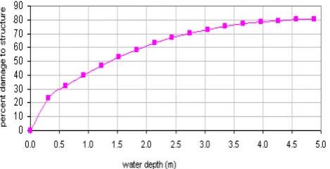
24 Fig. 1. Example of damage curve as function of the flow depth (U.S. Army Corps of
Engineers, 2000)
Fig. 1. Example of damage curves as function of the flow depth (US
Army Corps of Engineers, 2000).
2 Global and operational approach: vulnerability assessment
2.1 General purpose
An evaluation of the structural vulnerability to flood effect might be requested by the decision makers and stakeholders in order to predict, at a large scale (urban zone, city, region, etc), the socio-economic losses that may be caused by a pos-sible flood event.
This so-called building vulnerability regarding floods is usually measured by damage functions, where damage is re-lated to the water depth (flood level)(see example of this kind of curve found in Penning-Rowsell and Chatterton (1977); US Army Corps of Engineers (1997, 2000); Kelman (2002)). These functions are usually established from observations or modelling based on post-flood surveys. Figure 1 presents an example of water depth-damage function.
In fact, the damage level is very often related to the eco-nomic impact rather than to the bearing capacity of build-ing structure under the water loadbuild-ing. As the damage level should be related to the mechanical effect of the flood, we propose a new methodology that might be useful for quick evaluation at a large scale for masonry constructions. Obvi-ously, this global approach has to be calibrated on the basis of either structural damage database collected during post-flood disaster event or mechanical simulation. For this purpose, we present hereafter:
– a global and operational method that assesses the struc-tural damage as a combination of damage due to indi-vidual governing structural parameters;
– a simplified mechanical model that is considered for numeric simulations in order to calibrate this global method according to the theoretical (“effective” rather than supposed), structural failure risk, as detailed in Va-lencia et al. (2011).
Table 1. Parameters and their relative weight in Benedetti-Petrini’s
method.
Ki
ωi
Parameter D C B A
State of conservation 45 25 5 0 1.0
Soil slope and foundations 45 25 5 0 0.75
Conventional resistance 45 25 5 0 1.5
Horizontal diaphragm 45 15 5 0 1.0
Roof type 45 25 15 0 1.0
Horizontal regularity 45 25 5 0 0.5
Vertical regularity 45 25 5 0 1.0
No structural elements 45 25 0 0 0.25
Respect to the seismic norm 45 20 5 0 1.0
Quality of materials 45 25 5 0 0.25
Max. distance between walls 45 25 5 0 0.25
2.2 Existing global method for seismic vulnerability: Benedetti-Petrini Method
The empirical method developed in the 80s by Benedetti and Petrini (1984) is often used to evaluate the seismic vulnera-bility of buildings at a large scale. This method considers a set of structural parameters governing the seismic resistance: mechanical parameters, material quality, geometry, presence and distance between columns, beams, openings (windows and doors), resistance of the soil and its slope, state of con-servation and execution quality.
Each parameter is considered as ranging within four classes (A,B,C,D):A=very safe,B=safe,C=dangerous andD=very dangerous. To each parameter is allocated a relative weightωi and to each class(Aup toD) corresponds
a weightki(see Table 1). The vulnerability indexIvmay then be defined as:
Iv=
N
X
i=1
ki×ωi (1)
where:ki=influence of parameteriamong categoriesA,B, C orD;ωi=relative weight to each parameter among the
total numberN of parameters that govern the resistance or vulnerability of the considered structure.
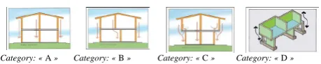
25 Category: « A » Category: « B » Category: « C » Category: « D »
Fig. 2. Effect of the vertical regularity of the masonry construction: « A = Very safe », « B = Safe », « C = Dangerous » and « D = Very dangerous »
Fig. 2. Effect of the vertical regularity of the masonry construction:
A=very safe,B=safe,C=dangerous andD=very dangerous.
2.3 New global method: probabilistic development and proposal
Derived from this traditional Benedetti method, a new method has been already developed within a probabilistic framework in the case of seismic vulnerability by Mebarki and Valencia (2003, 2004). In the present paper, it is ade-quately transformed and adapted to the case of flood by Va-lencia (2006). For this purpose, the vulnerability is expressed as a structural damage probability denoted Pf. Damage func-tions are expressed as funcfunc-tions of the flood water levelH.
Of course, the calibration of the governing parameters also influences the damage probability Pffunctions, used for this global approach, should be performed by developing and running a complete reliability analysis: probabilistic descrip-tion of the hazard, probabilistic descripdescrip-tion of the condidescrip-tional vulnerability and convolution integral providing the risk of failure (Aronica et al., 2011; Schumann et al., 2007). 2.3.1 Governing parameters and vulnerability identity
matrix Iv
In a first step, the structural vulnerability against flood is supposed to rely on the combined effect of the set of N
governing parameters. Actually, from post-flood damage re-ports (US Army Corps of Engineers, 1995; NFPC 1998), we adopt a set ofN=14 structural parameters that govern the structural capacity of a masonry building under the effect of hydro-dynamic pressure, as shown in Table 2.
The effect of each parameteriamong theNselected is so that the structure is classified into one of the adopted category of sensitivity to damage:A,B,CorD, as indicated in Fig. 2 for the “vertical regularity” parameter effect, for instance.
It is therefore required to establish the structure identity, i.e. vulnerability identity matrix Iv:
Iv=
Iv(1,1) ... ... Iv(1,M)
... ... ... ...
... ... ... ...
... Iv(i,j ) ... ...
... ... ... ...
... ... ... ...
Iv(N,1) ... ... Iv(N,M) (2)
where (see Table 2 as example):
– Iv(i,j )=1 if the parameteri,i from 1 up toN, is so that the structure has to be classified into the category
j,j from 1 up toM(M=4: categoriesA,B,CandD) – Iv(i,k)=0 fork6=j withk∈ {1..M}, i.e. for the 3 other
categories.
2.3.2 Vulnerability value matrix Pv
Furthermore, the individual contributions of the parameters are assumed to represent individual failure probability, called Pv, instead of using the parameter weighting adopted for Beneditti’s method
Pv=
Pv(1,1) ... ... Pv(1,M)
... ... ... ...
... ... ... ...
... Pv(i,j ) ... ...
... ... ... ...
... ... ... ...
Pv(N,1) ... ... Pv(N,M)
(3)
wherePv(i,j )=structural failure due to the parameteri(i= 1 up toN) when the structure is classified into the category
j (j=1 up toM).
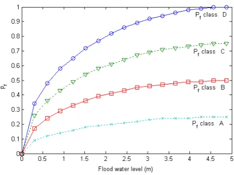
By analogy with the seismic vulnerability methodology proposed by Mebarki and Valencia (2004) and Mebarki et al. (2008) and based on damage curves collected from lit-erature (Penning-Rowsell and Chatterton, 1977; US Army Corps of Engineers, 1997, 2000), we assume, in the present study, that the relationship between the single contribution of each governing parameter and the water levelH follows an elliptic relationship (see Fig. 3)
Pvi(h)−Pvi(h0)
Pvi(hmax)−Pvi(h0) 2
+
hmax−h
hmax−h0 2
=1 (4)
where: h=is the corresponding value for water level H; wherehmaxis the maximal value ofH (upper bound of the validity domain) and h0 is a reference value; Pvi(h) is the
corresponding value of the probability Pv(i,j ) that repre-sents the single damage contribution of the governing pa-rameteri, in the structural category j, for the water depth
h. Figure 3 shows the evolution of damage risk according to flood level (hydraulic load) and according to each category (A,B,C,D). The accuracy and validity of this methodology can be analysed and calibrated on the basis of a complete reliability analysis (Valencia et al., 2011).
Table 2. Identity matrix for a given masonry construction considered as example.
Classes(j=1 up toM)
Parameter (i=1 up toN) D B C A
1 Number of storeys Iv(1,D)=1 0 0 0
2 Quality of materials 3 Wall geometry 4 Wall thickness
5 State of conservation 0 Iv(5,B)=1 0 0
6 Type of soil and foundations
7 Structural system: columns and beams 0 0 Iv(7,C)=1 0
8 Openings (doors and windows) 9 Horizontal and vertical regularity 10 Wall orientation with respect to the flow 11 Type of slab and roof
12 Location, environment 13 Potential debris
14 Basement and type of flooring
the flow velocity and hydraulic pressure), the probabilistic vulnerability (distribution of the bearing capacity) and the convolution product that provides the risk of failure. The methodology presented herein considers explicitly the evolu-tion of the condievolu-tional vulnerability according to the hazard level. It is then easy to derive the risk of failure as shown hereafter.
2.3.3 Governing parameter contribution to structural damage and vulnerability,Pf
Let us denote the global structural failure as a probabilistic combination of the individual failure due to each of the gov-erning parameters:
E=
N
[
i=1
Ei (5)
where E =“global failure” event of the structure;
Ei =failure event caused by the governing parameter i,i=1 up toN.
The corresponding damage probability or probability of global structural failure is derived from the elementary con-tributionEi due to each governing parameteri(Mebarki and
Valencia, 2003, 2004). Obviously, many of these individual contributions can be physically and statistically dependent. To take into account the existing dependency between indi-vidual events, one might consider either the covariance ma-trix or the conditional probabilities of occurrence between events. For instance, eigenvalues and eigenvectors of the correlation matrix could provide adequate governing com-bination of dependent individual events. Furthermore, nu-meric simulations can be run in order to analyse the risk sen-sitivity to each or sets among the whole governing param-eters and find the most influent for which special attention
26 Fig. 3. Evolution of damage risk Pf according to the flood water level
Fig. 3. Evolution of damage riskPfaccording to the flood level. needs to be devoted. The correlation and dependency be-tween events can be established according to experimental data and feedback or pure theoretical assumptions and devel-opments. In the present study, such experimental data are not available; it is not easy therefore to consider objective depen-dency. Therefore, the hypothesis of independency appears as a convenient hypothesis and simplifies the theoretical devel-opments. However, the proposed framework remains valid, as it can easily integrate the correlation matrix and condi-tional probabilities if available.
Hence, the present methodology assumes that the global vulnerability depends on the combined influence of individ-ual and independent governing parameters. It is therefore restricted to the case of acceptable hypothesis of indepen-dence. Actually, as a first approach, the individual eventsEi
Es=
N
\
i=1
Esi ⇒ Pf=1−
N
Y
i=1
(1−Pvi)=1−Pv:Iv (6)
as general term
¯
Pv(i,j )=1−Pv(i,j ) (7)
whereEs=structural capacity event of the structure as being the complementary event to the failureE; Esi =structural
capacity event due to parameteri,ifrom 1 toN;Iv=identity matrix of the structure;Pvi=Pv(i,j )=single damage con-tribution of parameter i for category j(j =1 up to M);
Pv=damage probability as a cumulative effect of all gov-erning parameters.
It is necessary to define the single contribution of each governing parameter,Pviwithi=1 `aN, regarding structural
damage probability,Pf.
2.3.4 Operational value of the failure probability,Pf
Various steps are required in order to evaluate the vulnera-bility and risk of failure for a given masonry construction:
– Step 1: vulnerability identity matrix Iv
the infield inspection (mainly visual) of a masonry construc-tion allows establishing its vulnerability identity matrix Iv. An evaluation sheet is developed: for each existing masonry structure, the inspector fills the evaluation form and estab-lishes the vulnerability identity matrix Iv;
– Step 2: flood level hazard parameter in order to estimate the structural damage and vulnerability Pf
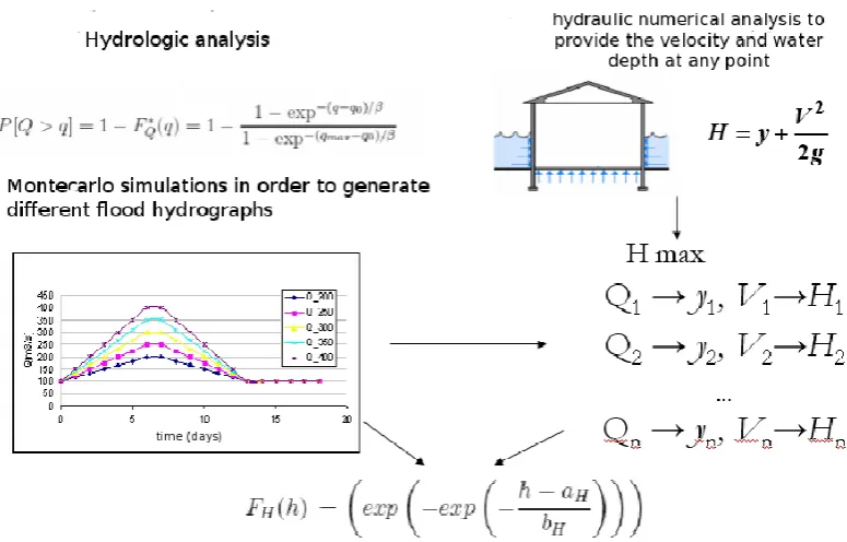
for each value of the flood water levelH, the exceedance probability is established by a Monte Carlo simulation (river discharge at the entrance of the channel, described as random variable, is coupled with a hydraulic numerical model in or-der to provide the velocity and water depth at any point of the considered zone for the whole constructions under study);
– Step 3: vulnerability value matrix Pvin order to esti-mate the structural damage and vulnerability Pf the individual contribution of the parameters allows estimat-ing the structural damage usestimat-ing Eq. (6);
– Step 4: GIS map of failure risk and structural damage due to flood effect
the structural risk of failure as well as the socio-economic expected losses can therefore be adequately summarised in GIS maps. These synthetic maps are useful and objective for decision making and resilience analysis of the zone or the set under study.
3 Application to a real case: Cheffes sur Sarthe (France) and comparison to Sarthe river flood in 1995
For illustration purposes, the village of Cheffes sur Sarthe in France has been selected as an experimental zone for this flood hazard analysis. Actually, the village has suffered many floods; for instance, in 1995, Sarthe river flooded 90 % of the residences and caused serious non-structural as well as structural damages.
Water depths and velocities in the floodplain are computed using HEC-RAS software developed by the US Army Corps of Engineers. This tool allows performing one-dimensional steady flow and unsteady flow based on the solution of con-tinuity and momentum equations for open channels. The data required for the river modelling are the discharge hy-drograph upstream, the Digital Terrain Model describing the floodplain and the geometry of the channel, as well as the hy-draulic properties of the river channel such as slope, shape, roughness, etc.
The flood hazard parameter is characterised in a proba-bilistic framework as the exceedance probability of a critical water levelH. The water levelH can be obtained through an hydrological model and hydraulic numerical study com-bined with Monte Carlo simulation from the dischargeQ, at the entrance of the channel, up to the flow depthyand veloc-ityV arising downstream in the floodplain. This procedure is shown in Fig. 4.
From these two last parameters, the flood water level is derived as:
H=y + V
2
2g (8)
where y=flow depth, V =velocity, and g=acceleration due to gravity.
Hydrodynamic pressure generated by the flood velocity depends on multiple factors and local conditions that are dif-ficult to evaluate. Actually, scouring, erosion and flood accel-eration, for instance, are not taken into account in this study. Flood frequency and exceedance probability of a critical dischargeQare calculated from a hydrological analysis. Wa-ter level frequency and exceedance probability, for a criti-cal water levelH, are calculated from a hydraulic numerical model combined with a Monte Carlo simulation, with a pro-cedure developed for this purpose, as shown in Fig. 4.
27
Fig. 4.
Flowchart of the procedure for the distribution of the critical water elevation HFig. 4. Example of data required for river modelling.
accurately predicted, the evolution of the conditional vulner-ability according to the hazard intensity (hydrodynamic lat-eral pressures), one may assume that the present methodol-ogy will provide correct risk values in absence of particular events, i.e. mudflows, debris and impacts, etc (Valencia et al., 2011). However, the present methodology can be signif-icantly improved by considering additional aspects such as debris flows (debris brought by streams, etc) and impacts as well as mud flows, as they are influent causes of structural damages; i.e. rocks, trees and vehicles for instance.
4 Flood risk and risk maps
The Geographic Information System (GIS) tools are ade-quate to represent risk at the regional or local scale. These tools allow storing data related to the individual information and the geometry for each building (governing parameters and class fromAup toD). Once the damage curve and the flood hazard are determined, the damage probability of each building can be easily computed and a risk map can be gen-erated in order to help decision-making.
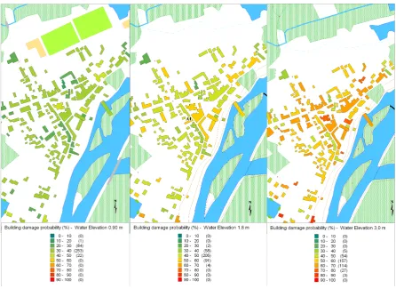
As an example, convivial interfaces have been developed under MapInfo in order to assess the risk at a regional scale. Cheffes sur Sarthe village was chosen as an experimental zone. Figure 5 shows the evolution of damage probability for three different levels of flood hazard (flow water elevation).
Thus, different scenarios can be studied in order to pre-dict the consequences of a flood. The implementation of the methodology within a GIS may produce useful information for decision-making processes.
This paper is, in fact, the first part of a complete study devoted to masonry structures vulnerability regarding natu-ral hazards (Valencia et al., 2011). Actually, the theoretical calibration of the global methodology detailed herein relies on a sophisticated and more detailed approach, i.e. proba-bilistic description of the hazard (river discharge, stream ve-locity and flow height), probabilistic description of the ma-sonry wall resistance to out-plane hydrodynamic pressure, numeric simulations and level-2 method in order to calcu-late the failure risk. Sensitivity analyses were required in order to compare the assumed evolution (adopted in the first part: elliptic evolution of the conditional vulnerability) to the numeric values. The individual influences as well as the re-lationships adopted for the evolution of the conditional vul-nerability (for each governing parameter), according to the hazard level, have been investigated in the case of masonry walls under out-of-plane loads. The results reported in the paper seem to be in good accordance with the evolution that has been adopted (Valencia et al., 2011).
5 Urban resilience under flood hazard
5.1 Aspects related to urban resilience
Fig. 5. Risk maps: evolution of damage failure of building for three different levels of flood
hazard (hydraulic load level).
Fig. 5. Risk maps: evolution of damage failure for building at three different levels of flood hazard (hydraulic load level).
mechanical barriers collapse under the natural event, they might generate other kinds of risks and lead to a disastrous situation. For instance, the domino effect may take place and give rise to catastrophic situation. Similar situations and successive sequences of failure happened during the recent tsunami in Japan during the Tohuku quake in March 2011.
However, vulnerability assessment of the existing con-structions is helpful in disaster reduction and mitigation since potential options might be prospected and adopted in order to strengthen the weak elements and reduce their vulnerabil-ity. Actually, the assessment of masonry vulnerability and damage prediction is a crucial step in order to elaborate ad-equate strengthening and protection. As these constructions are constitutive components of a wide territory, taking care of these components strengthens partly the territory and makes it more resilient. According to Folke (2011), “Resilience is the long-term capacity of a system to deal with change and continue to develop”. Urban areas are complex and dy-namic systems that are exposed to various hazards. Beyond the damages that might be suffered due to its vulnerability, a resilient territory needs adequate and efficient organization. Errors and disturbances generated during past catastrophic events should be detailed and analysed in order to stimu-late its memory and build its knowledge database (scientific,
economic, social, management, psychological and human behaviour, etc) and to be able to stand any similar event that might occur during its lifetime. Therefore, new/original or existing strategies can be developed or adopted for the reduction of constructions and territory vulnerability. GIS maps and socio-economic models are helpful in balancing the residual risk and the socio-economical aspects (Bimal Kanti Paul, 1997 ; Fedeski and Gwillian, 2007; Kazmierczak and Cavan, 2011; Linnekamp et al., 2011; Mens et al., 2011; Qi and Altinakar, 2011 ; Schelfaut et al., 2011; Treby et al., 2006; van Herk et al., 2011; van Ree et al., 2011).
An urban territory contains a large set of constructions, facilities, lifelines and human beings. Therefore, it is consid-ered as a complex system whose ability to remain in adequate service depends intimately on each constitutive element vul-nerability. Interactions and dependency between them have great influence on the system vulnerability and residual risk regarding a natural hazard such as floods, for instance. Ac-tually, the resilience of the territory depends intimately on the residual capacity, survival and recovery functions of the components and their resulting interactions, after an occur-rence of a disastrous event. The resilience improvement for a territory (neighbourhood, city, etc) requires also improve-ment of the structural bearing capacity of its constitutive
constructions. Furthermore, based on matrix values describ-ing the builddescrib-ings fragility and their socio-economic impor-tance, the Flood Vulnerability Assessment tool may be help-ful in ranking the buildings and organizing into hierarchy their priority of strengthen (Barroca et al., 2006).
5.2 Theoretical approach and socio-economic aspects for risk reduction at urban scale
The GIS maps of the flood hazard and the resulting struc-tural failure risk are therefore helpful for disaster mitigation and reduction. The natural disasters have, in general, several consequences of great importance.
Actually, optimization of the required expenses in order to reduce the expected risk, for the structural aspects, can be done theoretically by Mebarki et al. (2008):
Cg∗=minCg (9)
Cg= Ns X
k=1
(C0(k)+1C (k)+(Pf(k)+1Pf(k))×Cf(k)) (10) where: Cg=generalised cost over the whole set of Ns structures under study; Pf(k)=failure probability of the
k-th structure; Cf(k)=socio-economic consequences of k -th structure failure; 1Cf(k)=additional expenses due to strengthening or repair of thek-th structure in order to re-duce the failure risk by the order1Pf(k);k=1 up toNs.
In fact, this optimal global cost seems easy to be theoreti-cally calculated. However, several aspects such as respect of human life, pollutions and aggressive products release, losses of jobs, transportation breakdown, reactions of public opin-ion and political decisopin-ions make this optimizatopin-ion not so easy to be reached in practice. However, this theoretical formula-tion may also be helpful in prospecting objective investments and accompanying measures (survey and early warning sys-tems, automatic control and shutdowns, protective barriers, vicinity planning and organization) that result in risk reduc-tion, disaster mitigareduc-tion, and satisfy resilience and quick re-covery requirements.
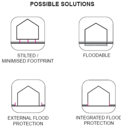
In practice, various solutions might be considered in order to protect the structure or reduce its vulnerability. For illus-trative purposes, at the individual building scale, one may consider various strategies for strengthening and reducing damage risk, as shown in Fig. 6:
– The building partly rests on stilts. Required retention capacity has to be performed within the building plot, while providing access in case of a flood.
– Part of the retention capacity is located within the building perimeters, as the ground floor is temporar-ily flooded. This requires both temporary installations, which can be disassembled in case of a flood and a cor-responding choice of materials. Staircases and other structural elements not to be flooded need to be built to be water-proof.
29
Fig. 6. Various solutions for structural resilience against flood hazard (Redeker, 2010).
Fig. 6. Various solutions for structural resilience against flood
haz-ard (Redeker, 2010).
– Retention capacity is located outside of the flood de-fense, creating flood-secure open space. The reduction of the retention area implies a deeper excavation which in turn requires a solution regarding the water return af-ter the flood event.
– Floodable areas directly adjoin the building.
6 Conclusions
This paper contributes to the development of a new integrated probabilistic methodology in order to assess failure risk of masonry constructions against flood hazard at the large scale. This methodology is based on the hypothesis that the global structural damage results from the contribution of several pa-rameters describing the structural capacity.
The approach requires to study and model flood hazard. The distribution of the discharge is derived from the maxi-mum discharge records and different flood scenarios are built from different flood hydrographs. The peak of these hydro-graphs is generated from a Monte Carlo simulation of the discharge, whereas the adopted shape of the hydrograph is derived from the reference discharge that corresponds to a historic flood. Hydraulic simulations are performed in order to estimate water level for a chosen floodplain cross section. Monte Carlo simulation is used in order to establish the dis-tribution of the critical water level in each location in the floodplain.
Actually, according to each parameter describing the struc-tural capacity, several classes can be considered. For each class, a conditional probability of failure risk is associated. Once the evolution of the failure risk according to flood level (hydraulic load) is adopted, the failure risk for a masonry construction can be assessed within a probabilistic frame-work: values 0 (no damage) up to 1 (collapse).
For illustration purposes, convivial interfaces are devel-oped under MapInfo in order to map the risk at the regional scale. This global approach appears greatly appropriate to evaluate the evolution of failure risk for masonry construc-tions under flood hazard. GIS maps of this risk are helpful for cost optimisation in order to reduce or mitigate the flood disaster at various scales: set of structures, city, region or even country.
Acknowledgements. This research study has been partly supported
by R´egion Ile de France, the CSTB (Centre Scientifique et Technique du Bˆatiment) and Universit´e Paris-Est Marne-la-Vall´ee (France).
Edited by: D. Serre
Reviewed by: three anonymous referees
References
Aronica, G. T., Candela, A., Fabio, P., and Santoro, M.: Estima-tion of flood inundaEstima-tion probabilities using global hazard indexes based on hydrodynamic variables, Phys. Chem. Earth, in press, doi:10.1016/j.pce.2011.04.001, 2011.
Barroca, B., Bernardara, P., Mouchel, J. M., and Hubert, G.: In-dicators for identification of urban flooding vulnerability, Nat. Hazards Earth Syst. Sci., 6, 553–561, doi:10.5194/nhess-6-553-2006, 2006.
Benedetti, D. and Petrini, V.: Sulla vulnerabilita sismica degli edifici in muratura: proposta di un metodo di valutazione, L’industria della costruzioni, 18, 66–74, 1984.
Borga, M., Anagnostou, E. N., Bl¨oschl, G., and Creutin, J. D.: Flash flood forecasting, warning and risk management: the HYDRATE project, Environ. Sci. Policy, 14, 834–844, 2011.
de Vries, D. H.: Temporal vulnerability in hazardscapes: Flood memory-netwroks and referentiallity along the North Carolina Neuse River (USA), Glob. Environ. Change, 21, 154–164, 2011. Fedeski, M. and Gwillian, J.: Urban sustainability in the presence of flood and geological hazards: The development of a GIS-based vulnerability and risk assessment methodology, Landscape Ur-ban Plan., 83, 50–61, 2007.
Fernandez D. S. and Lutz, M. A.: Urban flood hazard zoning in Tu-cuman Province, Argentina, using GIS and multicriteria decision analysis, Eng. Geol., 111, 90–98, 2010.
Folke, C.: Website of Stockholm Resilience Centre, available at: http://www.stockholmresilience.org/, last access: November 2011.
HEC: Hec-ras 3.1, hydrologic engineering center – river anal-ysis system, available at: http://www.hec.usace.army.mil/ publications/pubdownload.html (last access: March 2012), 2012.
Jonkman, S. N., Bockarjova, M., Kok, M., and Bernardini, P.: In-tegrated hydrodynamic and economic modeling of flood damage in the Netherlands, Ecol. Econom., 66, 77–90, 2008.
Kazmierczak, A. and Cavan, G.: Surface water flooding risk to ur-ban communities: analysis of vulnerability, hazard and exposure, Landscape Urban Plan., 103, 185–197, 2011.
Kelman, I.: Physical flood vulnerability of residential properties in coastal Eastern England, PhD thesis, University of Cambridge, UK, 2002.
Kelman, I. and Spence, R.: An overview of flood actions on build-ings, Eng. Geol., 73, 297–309, 2004.
Linnekamp, F., Koedam, A., and Baud, I. S. A.: Household vulner-ability to climate change: Examining perceptions of households of flood risks in Georgetown and Paramaribo, Habitat Int., Else-vier, 35, 447–456, 2011.
Marchi, L., Borga, M., Preciso, E., and Gaume, E.: Characterisation of selected extreme flash floods in Europe and implications for flood risk management, J. Hydrol., 394, 118–133, 2011. Mebarki, A. and Valencia, N.: Vuln´erabilit´e sismique des ouvrages
en mac¸onnerie, Revue Franc¸aise de G´enie Civil, Ed. Herm`es, 7, 471–498, 2003.
Mebarki, A. and Valencia, N.: Informal masonry structures: Seis-mic vulnerability and GIS maps, Masonry Int., British Masonry Society, 17, 18–25, 2004.
Mebarki, A., Genatios, C., and Lafuente, M.: Risques Naturels et Technologiques: Al´eas, Vuln´erabilit´e et Fiabilit´e des Construc-tions – vers une formulation probabiliste int´egr´ee, Presses Ponts et Chauss´ees, ISBN 978-2-85978-436-2, Paris, 2008.
Mens, M. J. P., Klijn, F., de Bruijn, K. M., and van Beek, E.: The meaning of system robustness for flood risk management, Envi-ron. Sci. Policy, 14, 1121–1131, 2011.
NFPC: Flood proofing performance, Tech. Rep., National Flood proofing committee, 1998.
Pappenberger, F., Beven, K., Frodsham, K., Romanowicz, R., and Matgen, P.: Grasping the unavoidable subjectivity in calibration of flood inundation models: A vulnerability weighted approach, J. Hydrol., 333, 275–287, 2007.
Paul, B. K.: Flood research in Bangladesh in retrospect and prospect: a review, Geoforum, 28, 121–131, 1997.
Penning-Rowsell, E. and Chatterton, J.: The Benefits of flood Alle-viation: A manual of assessment techniques, Saxon House, Farn-borough, 1977.
Qi, H. and Altinakar, M. S.: A GIS-based decision support sys-tem for integrated flood management under uncertainty with two dimensional numerical simulations, Environ. Model. Softw., 26, 817–821, 2011.
Redeker, C.: Zollhafen, Mainz project developer’s guide model project for flood adapted building, workshop report, 72 pp., 2010. Ruin, I., Creutin, J. D., Anquetin, S., and Lutoff, C.: Human ex-posure to flash floods – relation between flood parameters and human vulnerability during a storm of September 2002 in South-ern France, J. Hydrol., 361, 199–213, 2008.
Schelfaut, K., Pannemans, B., van der Craats, I., Krywkow, J., Mysiak, J., and Cools, J.: Bringing flood resilience into prac-tice: the FREEMAN project, Environ. Sci. Policy, 14, 825–833, 2011.
Hy-drol., 344, 96–111, 2007.
Treby, E. J., Clark, M. J., and Priest, S. J.: Integrated hydrodynamic and economic modeling of flood damage in the Netherlands, J. Environ. Manage. , 81, 351–359, 2006.
USACE: Flood proofing regulations, Tech. Rep., United States Army Corps of Engineers, 1995.
USACE: Yuba county damage survey following 1997 floods, post-flood assessment, Tech. Rep., United States Army Corps of En-gineers, 1997.
USACE: Economic guidance memorandum (egm) 01-03, generic depth-damage relationships. Tech. Rep., United States Army Corps of Engineers, 2000.
Valencia, N.: Risques naturels, al´ea, vuln´erabilit´e m´ecanique: cas de constructions en mac¸onnerie vis-`a-vis des s´eismes et inon-dations, Ph.D. thesis Universit´e Paris Marne-la-Vall´ee, 184 pp., France.
Valencia, N., Mebarki, A., and Salagnac, J. L.: Reliability and vul-nerability of masonry constructions: case of flood hazards, Nat. Hazards Earth Syst. Sci., submitted, 2011.
van Herk, S., Zevenbergen, C., Ashley, R., and Rijke, J.: Learning and Action Alliances for the integration of flood risk manage-ment into urban planning: a new framework from empirical evi-dence from The Netherlands, Environ. Sci. Policy, 14, 543–554, 2011.
van Ree, C. C. D. F., Van, M. A., Heilemann, K., Morris, M. W., Royet, P., and Zevenbergen, C.: FloodProBE: technologies for improved safety of the built environment in relation to flood events, Environ. Sci. Policy, 14, 874–883, 2011.
Versini, P. A.: Use of radar rainfall estimates and forecasts to pre-vent flash flood in real time by using a road inundation warning system, J. Hydrol., 416–417, 157–170, 2012.