Proc. IAHS, 374, 85–91, 2016 proc-iahs.net/374/85/2016/ doi:10.5194/piahs-374-85-2016
© Author(s) 2016. CC Attribution 3.0 License.
Open Access
ater
Resources
Assessment
and
Seasonal
Prediction
A tentative discussion on the monitoring of water
resources in China
Yang Jianqing, Dai Ning, Wu Mengying, and Wang Guangsheng
Bureau of Hydrology of Ministry of Water Resources, Baiguang Road, Beijing, 100053, China
Correspondence to:Yang Jianqing (jianqing.yang@mwr.gov.cn)
Published: 17 October 2016
Abstract. With the rapid economy development and social civilization progress, the Chinese Government also is improving ecological environmental conditions. More efforts have been made to solve water problems through the implementation of stringent water resources management, as a key government policy on water. Thus, mon-itoring of water resources has been strengthened, being a main component of the hydrological work in recent years. Compared with routine hydrological monitoring, water resources monitoring pays more attention to the quantity and quality variations of regional waters, to reflect the status of water in river basins and administrative regions. In this paper, the overall layout of the hydrometric network in China is presented, monitoring efforts of the natural water cycle and water consumptions are analyzed, methodologies of water resources monitor-ing, which are commonly applied in the country, are summed up. Taking the hydrometric network planning on interprovincial boundary waterbodies as example, a summary of the planning at interprovincial boundary river sections is presented. The planning can meet the need of water resources management of administrative divisions. It can also improve the overall water resources monitoring for the country.
1 Introduction
Water is not only an irreplaceable natural resource, but also an important ecological and environmental element. Accord-ing to the second National Water Resources Assessment in China, the total amount of water resources of the country was about 2841 billon m3in early 21st Century, which ranks the 6th place in the world. However, the amount of available wa-ters in China per capita is about 2200 m3, only 28 % of the world average, and the volume of water per unit land area is 83 % of the world average. Moreover, China’s water re-sources are spatially unevenly distributed. Where in southern region, land area accounts for 36 % of the country, population accounts for 40 %, and the Gross Domestic Product (GDP) is about 56 %, with 81 % of total water resources. While in northern region, the land area is about 64 %, population is about 46 %, and GDP accounts for 44 %, but the total water resources is only 19 % of the country. The regional distribu-tion of water resources in the country according to the China Water Resources Bulletin is shown in Fig. 1.
With the impact of climate change and human activities such as urbanization in the country, water scarcity due to
changes of surface conditions in the north and water pollu-tion in the south have not been effectively curbed. Contradic-tion between water supply and water demand is yet outstand-ing, and water utilization efficiency is still poor in compari-son with those in developed countries.
comprehen-Figure 1.Distribution of water resources in China.
sive situation of water resources monitoring in China, taking the hydrometric network planning for interprovincial bound-ary rivers as an example. The distribution of monitoring sta-tions at interprovincial boundary river secsta-tions is proposed to meet the needs of water resources management for provincial administrative divisions. The planning provides constructive guidance to the development of water resource monitoring of China.
2 Hydrometric network development
Water resource monitoring involves, for example, analyzing the water quantity, water quality, distribution of water status, and water exploitation, water utilization and conservation of water resources (Yao et al., 2013; Zhang et al., 2015). A hy-drometric network is the basis for water resources monitor-ing, investigation, analysis and evaluation (Maidment, 1993; WMO Secretariat, 1988).
At present, water resources monitoring in China can be generally distinguished into two forms: dynamic monitoring for the natural water cycle and monitoring for water utiliza-tion. Where, dynamic monitoring for natural water cycle fo-cuses on the monitoring of hydrological features of water bodies, including rivers, lakes, water channels, as well as re-gional groundwater. Monitoring for water utilization focuses on the monitoring of water supply, water use and water con-sumption processes through human activities, including wa-ter supply sources, wawa-ter pipelines, sewage outlets and so on. For a long time, the dynamic monitoring of natural water cy-cle was given priority in the work of the hydrologic sector, while measurement of the water utilization status remains to be further improved. Following the implementation of strin-gent water management in recent years, monitoring for inter-administrative boundary water sections become a new task to meet the needs of water resources management for adminis-trative divisions. In addition, for those areas and water bodies without hydrological stations, water survey is usually carried out at a regular base, including both regional water quantity and water quality investigations.
Figure 2.Structure of hydrological stations in China.
2.1 Dynamic water resources monitoring
After decades of development, China has established a com-prehensive hydrological monitoring network all over the country, and accumulated a large amount of hydrological data, which provides a strong basis for the management of water resources. The hydrometric network has been long set up according to the needs of flood defence, drought relief and disaster reduction in river basins. Currently, there are in to-tal 93 617 different kinds of hydrological monitoring stations (Deng, 2015). The structure of the country’s hydrological sta-tions is shown in Fig. 2.
The dynamic monitoring of water resources based on ex-isting hydrological stations is carried out, as follows.
i. Monitoring of surface water flow. Traditional hydrolog-ical monitoring stations are long deployed in line with the distribution of watersheds. The average density of national hydrological stations is 1966 km2site−1, where 3172 stations are the basic monitoring stations of main river control sections, 1710 hydrological stations are for intermediate and small rivers. Moreover, there are 46 980 precipitation monitoring stations, 21 evaporation monitoring stations, and 1927 soil moisture monitoring stations. These provide a full coverage of major river basins all over the country. With the data collected, anal-ysis of hydrological regime of rivers and calculation of runoff changes in basins can thus be made. Hydrological characteristics and water resources conditions of river basins can be evaluated to manage river flow and water storages, which provide a solid foundation for evalua-tion of regional water resources.
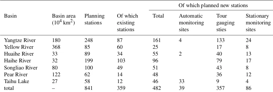
exist-Table 1.Summary of the planned monitoring stations distributed by main river basins.
Of which planned new stations
Basin Basin area
(104km2)
Planning stations
Of which existing stations
Total Automatic
monitoring sites
Tour gauging sties
Stationary monitoring sites
Yangtze River 180 248 87 161 4 133 24
Yellow River 368 85 60 25 17 8
Huaihe River 33 89 34 55 2 40 13
Haihe River 32 199 103 96 79 17
Songliao River 80 100 49 51 43 8
Pear River 122 62 14 48 36 12
Taihu Lake 27 58 12 46 33 9 4
total – 841 359 482 39 357 86
ing groundwater monitoring stations are distributed in northern China, and many are water extraction wells and irrigation wells, which are manually monitored. The present network density and regional layout cannot meet the increasing demand for information on water resources management. To strengthen and improve groundwater monitoring, the Ministry of Water Re-sources and the Ministry of Land ReRe-sources jointly proposed a project to measure the groundwater state through automatic monitoring systems (Qiao, 2009; Yang and Zhang, 2008). The project plans to construct a total number of 20 401 automatic groundwater mon-itoring stations. Monmon-itoring for groundwater overdraft areas and different groundwater sources are particularly strengthened. Effective monitoring will be achieved for most of the country’s plains, which cover an area of 3.5 million km2.
iii. Monitoring of water quality elements. There are more than 12 000 surface water quality monitoring sections, where, 596 sections focus on the monitoring of inter-provincial boundary waters (buffer zones), 1507 sites are monitoring water supply sources, and 5064 sec-tions are for the 4493 state-administrated water func-tional zones (areas defined according to the natural wa-ter conditions and regional development targets) across the country. In addition, water quality monitoring is car-ried out at both 4640 waste water outlets to rivers and 4115 representative groundwater monitoring wells.
To strengthen and promote the work of water quality mon-itoring, the Ministry of Water Resources completed the na-tional water resources conservation monitoring planning in 2013. A total number of 16 392 surface water quality moni-toring sections are planned, providing a full coverage of the country’s major water bodies. It can provide a strong support to the country’s water conservation and protection goals by 2020.
2.2 Monitoring for administrative regions
Following the step-wise implementation of a stringent wa-ter resources management, “three red lines” were formulated, i.e. a controlling index of the total amount of water exploited, efficiency of water use, and water pollutions for each admin-istrative region. Among them, the controlling index of total exploited water for the country is 670 billion m3by 2020, and 700 billion m3by 2030. Thus, monitoring of water resources for trans-administrative boundary water bodies appeared to become essential for the implementation of stringent water resources management.
To examine and evaluate the government performance on rational water consumption and effective water conser-vation in the administrative regions, the Ministry of Wa-ter Resources has put forward the intensive monitoring for the trans-administrative boundary water bodies based on the monitoring network planning (Zhang et al., 2012). The plan-ning focuses at the provincial administrative sections or at interprovincial boundary rivers. New hydrological stations were further deployed in comply with the existing hydrolog-ical monitoring network. Summaries of the planning are as follows, as an example.
i. Principle of the planning. Monitoring stations at provin-cial administrative sections of interprovinprovin-cial boundary rivers are deployed to comply with following principles: (a) major river stems and their first-order tributaries, (b) rivers whose catchment area greater than 1000 km2, (c) key interprovincial water transfer project or inter-basin water diversion project channels, (d) water vulner-able areas or seriously polluted areas of the interprovin-cial boundary water bodies.
are existing monitoring stations, accounting for 43 % of the total number, while 482 sites are new stations, ac-counted for 57 % of the planning. To promote the au-tomatic monitoring capacity, 82 % of the new sites are either tour gauging or automatic monitoring stations. To meet the requirement of monitoring regulations of wa-ter resources, monitoring of wawa-ter quality will be syn-chronized with monitoring of water flow for all the 841 sites. Sketch map of the planned hydrological monitor-ing stations for interprovincial boundary rivers is shown in Fig. 3.
In the planning, there are 367 interprovincial boundary rivers, whose drainage areas are above 1000 km2. Monitoring sta-tions for 333 interprovincial boundary rivers at their provin-cial administrative sections are implemented, which account for 91 % of the total number of 367 rivers. Among which, 213 rivers are deployed with existing monitoring stations, accounting for 58 % of the total number of interprovincial boundary rivers. Analysis is further made by the method of area-runoff depth correlation algorithm. It shows that, with the planned monitoring capacity, an average 86 % of total inflow and 88 % of total outflow for provincial administra-tive regions can be effecadministra-tively examined. Remaining rivers without planned stations are mostly located in mountainous areas, which are deserted areas with little water management demands. Taking into account the work done for ungauged areas, the planning can meet the increasing needs of regional water management for provincial administrative divisions.
2.3 Monitoring for water use
Monitoring for water use is usually carried out in real-time through monitoring stations. However, for those areas with-out monitoring stations, it can also be made through water investigation.
i. Monitoring for water consumptions. In comparison with the dynamic monitoring of the natural water cycle, mon-itoring for water consumptions is relatively weak in China. The monitoring ability is poor when compared with those developed countries (Martin, 2008; Office of the Auditor General of Canada, 2010; Wang et al., 2014). At present, a statistic method, such as water con-sumption quotas, is widely used for the measurement of water consumption in China. Nearly 30 % of indus-trial and 70 % of agricultural water use have not yet been directly metered. Based on the current monitoring situation, following principles are set up to strengthen the real-time monitoring of water consumptions by fo-cusing on those important users: (a) centralized public and industrial users with annual surface water consump-tions above 300 million m3, (b) licensed public and in-dustrial users with annual groundwater consumptions above 50 million m3, and (c) users taken water from vulnerable and sensitive water-bodies for specific
pur-pose. Based on the principle above, a pilot project on comprehensive water resources monitoring and man-agement for 38 cities in 22 provinces has been estab-lished by the Ministry of Water Resources. The project provides online monitoring for 2891 drinking water sources, large water users, groundwater overdraft areas and water functional zones since 2006. Starting from 2012, a state project on water resources monitoring ca-pacity building has been put forward. Online monitor-ing of 8558 key water users at national level, includ-ing 5576 surface water users, 2886 groundwater water users, and 96 locations with conjunctive use of surface and groundwater have been further put into practice. In combination with the monitoring carried by local coun-ties, around 80 % of the total licensed water thus can be effectively monitored.
ii. Water investigation. Water investigation is carried out at regular basis for those areas without monitoring sta-tions. Investigation for water flow is conducted once a year in general, and investigation for waste water into rivers and lakes is generally conducted every 1 to 3 years. These investigations are carried out in accordance with the Technical Guideline for Water Resources Mon-itoring. The main technical work is as follows: (a) inves-tigation of natural water quantity, including river chan-nel flow, inflow and outflow of interprovincial boundary rivers, water storage and groundwater, (b) investigation of water exploitation and utilization, including surface water consumptions, groundwater exploitation, ground-water recharge, mining drainage survey, and (c) spe-cific investigations, including industrial and domestic wastewater into rivers and lakes, irrigation return flow. Analysis shows that, a comprehensive hydrometric network has been developed in China. The spatial distribution of hy-drological stations is by far rational and practical. The net-work distribution and monitoring elements are basically con-sistent with regional economic and social development pat-terns. However, due to the spatially and temporally unbal-anced economic development of the country, the hydrologi-cal monitoring network has also been unevenly distributed. It is clear that, the monitoring network for water utilization is still insufficient. Particularly, those monitoring stations for inter-administrative boundary rivers are inadequate and mon-itoring for water exploitation and consumption are poor. De-mands for timely and fully understanding of the regional wa-ter situation cannot be satisfied. There is an urgent need to ac-celerate the implementation of the designed monitoring net-work.
3 Application of monitoring technology
Figure 3.Sketch map of the planned hydrological monitoring stations for interprovincial boundary rivers.
With the rapid development of modern science and technol-ogy, automatic monitoring technology has also been widely introduced in water resource monitoring (Yao et al., 2013; Zhang et al., 2003). Some examples of technology of main hydrologic elements monitored are as follows:
i. Monitoring of water levels. Currently, automatic moni-toring of water levels is extensively applied in the coun-try. According to statistics, more than 90 % of the sur-face water levels in the country are automatically moni-tored. However, about 90 % of groundwater monitoring is still manually done. The capacity of automatic moni-toring of groundwater will be significantly improved af-ter the implementation of the state automatic groundwa-ter monitoring system. For automatic wagroundwa-ter level moni-toring, the float type, pressure type and bubble type wa-ter level mewa-ters are the main instruments applied for both surface water and groundwater. According to the technical regulations on water level monitoring, some manual checks of the water level is still necessary for the automatic monitoring sites. It is mainly used to cross
check the automatic measurement instruments by man-ual readings.
correlation can be established, then people are encour-aged to make use of the rating-curve instead of the direct flow measurement.
iii. Monitoring of pipe flow. Monitoring for pipe flow can also be distinguished as velocity-area method and vol-umetric method in principle. For the monitoring of in-dustrial and domestic pipe flow, both methods are ex-tensively used. Types of popular instruments include the electromagnetic flow meter, acoustic flow meter, water meter and others. For the monitoring of irrigation water, above monitoring technology can generally be applied. While for the measurement of groundwater exploita-tions, indirect measurement such as electricity use, ir-rigation water meter and water consumption quotas are the typical methods utilized.
iv. Monitoring of water quality. Water quality monitoring can generally be divided into two kinds, one is the man-ual monitoring, and the other is automatic measurement (Chen et al., 2014). At present, no matter if it is surface water, groundwater, a natural water body or an artificial pipeline, manual sampling in combination with labora-tory analysis is still the main method for water quality monitoring. Limited parameters are monitored through automatic measurement of the electrode method and on-line analysis technology.
v. Monitoring of precipitation, evaporation and water stor-age. For the monitoring of water storage, water levels are automatically monitored, and the storage capacity of reservoirs and other water bodies are usually obtained through the water level-volumetric correlations. For the monitoring of precipitation, automatic monitoring has been realized for all stations; while pan evaporation will remain to be manually monitored in general.
4 Discussions and suggestions
Water resource monitoring is important for better under-standing of regional water conditions and for evaluation of water resources. In this paper, the overall hydrometric net-work in China is introduced, and the classification of the monitoring network and monitoring technology commonly applied in the country are presented. As an example, the monitoring network planning for interprovincial boundary rivers is demonstrated to meet the increasing demand of wa-ter management. It can be seen that in recent years, much attention has been paid to the monitoring of water resources in China. The water resources monitoring provides a reliable scientific basis for water exploitation, utilization, configura-tion, protection and conservation. Strengthening the monitor-ing of water resources is not only the requirement of imple-menting stringent water resources management, but it also is an important part of the development of hydrological work.
In recent years, China has been facing serious water prob-lems, including water shortage, water pollution, and ineffi-cient water use, while water resource monitoring still was fundamentally weak. Current monitoring cannot meet the ac-tual needs of water management yet. In view of the outstand-ing problems in current water resources monitoroutstand-ing, the fol-lowing suggestions are made on the establishment of a sys-tematic monitoring network:
i. Traditional hydrological monitoring mainly focused on the monitoring of hydrological elements of the natu-ral water cycle, including its spatial and temponatu-ral dis-tributions, to better understand regional water quantity and quality conditions. Future monitoring of water re-sources should be put forward to comply better with the regional water status. Synchronized water quantity and water quality monitoring, regional water balance assess-ment in combination with measureassess-ments and investiga-tions, should be implemented in water resource moni-toring.
ii. Considering the relatively weak water resources moni-toring, especially the monitoring of water exploitation and consumption in the country, there is an urgent need to accelerate the implementation of monitoring plan-ning of the interprovincial boundary river sections, as well as the planning of the water resources monitoring capacity-building and automatic groundwater monitor-ing. Thus, the monitoring network can be optimized, network density can be improved, and water resources monitoring can be strengthened.
iii. Taking into account the cost of human resources for stationary monitoring stations, it is required to actively promote automatic monitoring to increase the water re-sources monitoring. Monitoring frequency and accuracy could also been improved, to satisfy the growing de-mand for water resources management.
5 Data availability
The “Directory of rivers to be carried out for water alloca-tion (monitoring and assessment) during the period of 2013– 2015”, which is the basic data for the work of hydromet-ric monitoring planning on inter-provincial boundary river sections is avaible in the Supplement. Access to the hydro-metric network data in part1 of the manuscript is available on the government web (http://www.mwr.gov.cn/zwzc/hygb/ swqknb/, Bureau of Hydrology of Ministry of Water Re-sources, 2015).
Acknowledgements. The work is supported by Zhang ShuAn from the Bureau of Hydrology of the Ministry of Water Resources. Special thanks to Henny A. J. van Lanen from the Wageningen Uni-versity for his comments and revision to improve the paper.
References
Bureau of Hydrology of Ministry of Water Resources: 2014 Annual Report of National Hydrological Statistics, Shangdong Hydro-logical Press, Shangdong, China, http://www.mwr.gov.cn/zwzc/ hygb/swqknb/, 2015.
Chen, Z. Z, Yin, J., and Liang, S. S: Outlook for automatic water quality monitoring applied in Yangtze Estuary, Water Purifica-tion Technology, 33, 81–83, 95, 2014.
Deng, J.: 2014 Annual Report of Hydrological Development, Shan-dong Hydrological Publishing House, ShangShan-dong, China, 37–40, 2015.
Lin, Z. D., Liu, H. S., Jiang, Y. X., Cheng, Y. L., and Zhang, H.: Technical standard for groundwater monitoring, Chin Wa-terpower Press, Beijing, China, 2005.
Liu, D. S., Jin, X. P., Zhu, X. Y., Zhou, F. Z., and Wei, J. C.: Code for discharge measurement of acoustic Doppler current, China Waterpower Press, Beijing, China, 2006.
Maidment, D. R.: Handbook of Hydrology, McGraw-Hill, 1993. Martin, G. (Ed.): Water Framework Directive, translated by:
In-ternational Economic and Technical Cooperation Center of the Ministry of Water Resources, China Waterpower Press, Beijing, China, 2008.
Office of the Auditor General of Canada: Network design for water quality monitoring of surface freshwaters: a review, 2010 Fall Report of the Commissioner of the Environment and Sustainable Development, 1–17, 2010.
Qiao, G. J.: Study on the functional area of groundwater in China, China Hydrology, 29, 90–93, 2009.
Wang, R.: Real time monitoring and analysis of shallow freshwater resources, Resources and Environment, 18, 115–116, 2014. Wang, X. K., Qu, Y., Zhi, Y., and Ren, Y. F.: The monitoring
sys-tem for long-term urban ecosyssys-tem study in USA and China, Ad-vances in Earth Science, 29, 617–623, 2014.
Wang, X. J., Zhang, J. Y., Shamsuddin, S., He, R. M., Xia, X. H., and Mou, X. L.: Potential impact of climate change on future wa-ter demand in Yulin city northwest China, Mitigation and Adap-tation Strategies for Global Change, 20, 1–19, 2015.
WMO Secretariat: Water resources assessment activities: handbook for national evaluation, UNESCO Paris, World Meteorological Organization, Geneva, 1988.
Yang, Y. C., Chen, H. F., Wang, B. C., Zhu, X. Y., and Wang, Y. C.: Code for liquid flow measurement in open channels. China Waterpower Press, Beijing, China, 1993.
Yang, J. Q. and Zhang, S. A.: General discussion on groundwater monitoring and prediction studies in China, in: Proceedings of the Symposium on Water Ecological Monitoring and Analysis, Shandong Atlas Publishing House, Shandong, China, 207–211, 2008.
Yao, Y. X., Zhang, S. A., Yang, J. Q., Fang, R., and Yang, G. L. (Eds.): Water resource information monitoring and transmission technology, Hohai University Press, Nanjing, China, 2013. Zhang, J. Y., Zhu, C. N., Cui, J. J., Tang, Z. S., and Xu, Z. C.:
Technical specification for hydrologic data acquisition system, China Waterpower Press, Beijing, China, 2003.
Zhang, S. A., Yang, J. Q., Lin, Z. D., Fang, R., Yang, G. L., Wei, Y. H., and Li, S. B.: Discussion on the outline of water re-sources monitoring network planning in China, in: Proceedings of the Conference on Academic Hydrology 2012, Hohai Univer-sity Press, Nanjing, China, 337–343, 2012.