Earth Planets Space,59, 375–380, 2007
Crustal structure of the southwestern margin of the Kuril arc sited in the
eastern part of Hokkaido, Japan, inferred from seismic
refraction/reflection experiments
Eiji Kurashimo1, Takaya Iwasaki1, Naoshi Hirata1, Tanio Ito2, and Yoshiyuki Kaneda3
1Earthquake Research Institute, the University of Tokyo, 1-1-1 Yayoi, Bunkyo-ku, Tokyo 113-0032, Japan 2Department of Earth Sciences, Faculty of Science, Chiba University, 1-33 Yayoi-cho, Inage-ku, Chiba 263-8522, Japan
3Japan Agency for Marine-Earth Science and Technology, 2-15 Natsuhima-cho, Yokosuka 237-0061, Japan
(Received April 12, 2006; Revised December 28, 2006; Accepted February 13, 2007; Online published June 8, 2007)
Hokkaido Island in northern Japan is located at the intersection of the Kuril and Northeast Japan arcs. Eastern Hokkaido represents the southwestern margin of the Kuril arc that evolved as an oceanic island arc, but its crustal structure has remained unclarified. In the summer of 2000, a highly dense onshore-offshore integrated seismic experiment was conducted in order to reveal the entire crustal section covering from the Kuril Trench to the back-arc basin of the Okhotsk Sea crossing eastern Hokkaido. High-quality refraction/wide-angle reflection data collected for the onshore survey line delineated a detailed crustal structure of easternmost part of Hokkaido Island. Our seismic velocity model shows a good correlation with the surface geology along the profile. The notable feature of the velocity model is the existence of a 6.0-km/s layer beneath the onshore survey line. A reflective middle to lower crust is also found beneath eastern Hokkaido. These results indicate that the southwestern margin of the Kuril arc is in a matured state of oceanic island-arc crust.
Key words: Crustal structure, southwestern margin of the Kuril arc, seismic refraction and reflection experi-ments, mature oceanic island-arc crust.
1.
Introduction
Hokkaido Island in northern Japan is located at the inter-section of two active island arc-trench systems: the North-east Japan arc-Japan Trench and the Kuril arc-Kuril Trench systems (Fig. 1). Hokkaido is divided into three major provinces with regard to its pre-Neogene geology whose general trend is oblique to these arc-trench systems: West-ern, Central, and Eastern Hokkaido (e.g. Aritaet al., 1998). Western Hokkaido is the northern extension of the North-east Japan arc, which consists of a late Jurassic accre-tionary complex with Cretaceous granitic intrusion (e.g. Kawamuraet al., 1986; Kimura, 1994). Central Hokkaido is composed of Cretaceous to early Paleogene accretionary complexes often covered by forearc basin sediments (e.g. Kimura, 1994). Eastern Hokkaido represents the south-western margin of the Kuril arc, whose oldest rocks are the latest Cretaceous andesitic volcanic and sedimentary rocks, which probably form the ancient Kuril arc (Kimura and Tamaki, 1985; Kimura, 1994). The crustal evolution of Hokkaido Island has been dominated by a series of accre-tion and collision processes occurring from the late Jurassic to the present. Several tectonic models for Hokkaido have been proposed. Kimura (1994, 1996) suggested that the an-cient Kuril arc situated along the southern margin of the Okhotsk Plate collided with the Asian continental margin in the late Eocene. After this collision, the northern part
Copyright cThe Society of Geomagnetism and Earth, Planetary and Space Sci-ences (SGEPSS); The Seismological Society of Japan; The Volcanological Society of Japan; The Geodetic Society of Japan; The Japanese Society for Planetary Sci-ences; TERRAPUB.
of the Okhotsk Sea was trapped, which caused the cessa-tion of subduccessa-tion along Hokkaido, Sakhalin, and the south-ern margin of Siberia, with only the Kuril trench surviving. Since the late Miocene, the Kuril forearc sliver has been migrating southwestward and colliding with the Northeast Japan arc (e.g. Kimura, 1986) due to the oblique subduction of the Pacific Plate along the Kuril trench. In order to in-vestigate the structural variations and deformations associ-ated with the accretion and collision tectonics in Hokkaido, several controlled-source seismic experiments including re-fraction and reflection profiling were conducted (e.g. Arita et al., 1998; Iwasaki et al., 1998; Tsumura et al., 1999; Iwasakiet al., 2004).
The easternmost part of Hokkaido is geologically con-sidered to be the southern margin of the Kuril arc. Al-though the Japan National Oil Corporation (JNOC) con-ducted several seismic reflection experiments (JNOC, 1984, 1985, 1990, 2002) in this region, these studies shed light only upon a shallow crustal structure, and little is known about the entire crustal structure. In the summer of 2000, a highly dense onshore–offshore integrated seismic exper-iment was conducted in order to reveal the crustal section from the Kuril Trench to the back-arc basin of the Okhotsk Sea crossing eastern Hokkaido, which corresponds to the southwestern margin of the Kuril arc. Nakanishi et al. (2004) showed the detailed crustal and uppermost mantle structural model across the seismogenic zone of the south-ern Kuril Trench from off-shore data. In this paper we present the crustal structure beneath eastern Hokkaido ob-tained from on-shore data and discuss the maturity level of
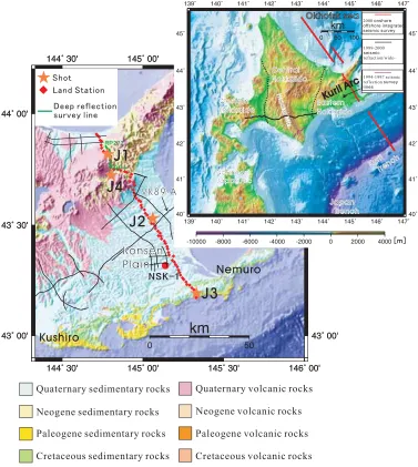
Fig. 1. Location map of the 2000 onshore–offshore integrated seismic experiment across eastern Hokkaido, Japan. The survey lines are shown in red. The re ection lines carried out from 1994 to 1997 (Tsumuraet al., 1999) and refraction/wide-angle re ection lines carried out in 1999–2000 (Iwasakiet al., 2004) are also shown. The explosive shots (star symbols) and the land seismic stations (diamond symbols) are shown with a simpli ed geological map (Geological Survey of Japan, 1992). The green line denotes the deep seismic re ection survey line using a digital telemetry recording system. The red circle symbol labeled ‘NSK-1’ denotes the drilling site (JNOC, 2002). The black lines denote previous seismic re ection survey lines conducted by the Japan National Oil Corporation (JNOC, 1984, 1985, 1990, 2002). The seismic re ection pro le along the VK89-A was reported by JNOC (1985).
the southwestern margin of the Kuril arc crust. According to Kimura (1996), the Kuril arc is an oceanic island arc. However, previous wide-angle seismic investigations in the eastern half of the Hokkaido Island provide no positive evi-dence of an oceanic island arc. The easternmost part of the Hokkaido has been less affected by the collision than previ-ous survey areas, therefore, its crustal structure is expected to contain some information on the crustal evolution on the southwestern margin of the Kuril arc.
2.
Experiments and Data
In the summer of 2000, a highly dense onshore–offshore integrated seismic experiment was conducted in order to re-veal the crustal section from the Kuril Trench to the back-arc basin of the Okhotsk Sea crossing eastern Hokkaido (Fig. 1). Seventy-four portable seismographs were
E. KURASHIMOet al.: CRUSTAL STRUCTURE OF THE SOUTHWESTERN MARGIN OF THE KURIL ARC 377
Fig. 2. Observed seismograms, calculated travel times, synthetic seismograms, and ray diagrams for shots J1 (left) and J3 (right). The horizontal axis represents the source-receiver offset. (a) Observed seismograms. Band-pass lter (1–25 Hz) is applied. Each trace is normalized by its maximum amplitude. The reduction velocity is 6 km/s. We obtained high signal-to-noise ratio data along the entire length of the onshore survey line. The calculated travel times for the nal crustal model (Fig. 3) are superimposed on the observed seismograms. (b) Ray theoretical synthetic seismograms. (c) Ray diagram. The ray paths and calculated travel times correspond in color.
sampling rate of 250 Hz. A 50-m group interval of 10-Hz geophones was used. We obtained high signal-to-noise ra-tio data along the entire length of the onshore survey line (Fig. 2).
3.
Analysis and Results
3.1 Two-dimensional velocity structure
The two-dimensional (2-D) velocity structure beneath eastern Hokkaido was derived by a 2-D ray-tracing method using the rst arrivals and later phases observed on the survey line so as to determine the velocities and the ge-ometry of the velocity interface. In order to construct an initial model of the ray-tracing analysis, the rst arrivals from J1-J4 were inverted by using an extended time-term method (Iwasaki, 2002) so as to obtain the rough geome-try of the surface layer and the basement velocity. Subse-quently, the ray-tracing method was employed to calculate the wave eld in the 2-D varying velocity model (Cerven´y and Psenc´k, 1983). We obtained a model that could pro-vide a reasonable explanation for both of the observed travel times within a 0.1-s error and the gross features of the am-plitudes (Figs. 2 and 3). Our model indicates a lateral
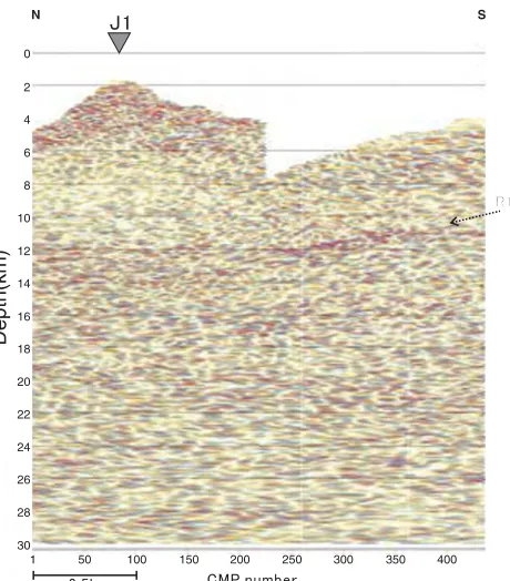
varia-tion of the surface layer. Although its velocities range from 1.7 to 4.3 km/s, signi cant velocity changes are found at distances of 30 and 70–80 km (Fig. 3). The thickness of the surface layer is 0.2–3 km in the northern part of the pro le, while it is nearly 4–5 km in the southern part. The velocity of the top of the uppermost crystalline crust is 6.0 km/s, and this 6.0-km/s layer exists beneath the entire onshore survey line. In Fig. 2, the later phase, L1, is a re ector from an interface located at a depth of 9 km beneath the central part of survey line, whose strong amplitudes required a veloc-ity jump of 0.3 km/s at the corresponding interface (Fig. 3). The resultant velocity below the interface is 6.4 km/s. As described in Section 3.2, the data from the digital telemetry seismic recording system strongly indicate mid-crustal re-ectors below a depth of 10–12 km in the northern part of the pro le.
3.2 Re ection image
Fig. 3. P-wave velocity structure derived by a 2-D ray-tracing method. The horizontal axis represents the distance from the north end of the onshore survey line. The shot positions are denoted by solid triangles at the top of gure. TheP-wave velocities are shown using a color scale. The numerals indicate the P-wave velocities in km/s. The solid counter lines denote theP-wave velocity in km/s. The counter interval is 0.4 km/s. The areas with no ray coverage are represented as blanks. The red line denotes the mid-crustal re ector (R1) obtained from the seismic re ection image (Fig. 5).
Fig. 4. Unmigrated stacked time section of the deep re ection survey using a digital telemetry recording system. See text for detailed expla-nation.
(CMP) processing steps, including post-stack migration and depth conversion. A static correction for the shallow low-velocity layer was applied based on the refraction analysis by using the extended time-term method (Iwasaki, 2002). The length of the automatic gain control operator is 4 s. The normal moveout and depth conversion velocities were based on the 2-D velocity structure (Fig. 3). In Figs. 4 and 5,
Fig. 5. Post-stack migrated depth section of the deep re ection survey using a digital telemetry recording system. See text for detailed expla-nation.
E. KURASHIMOet al.: CRUSTAL STRUCTURE OF THE SOUTHWESTERN MARGIN OF THE KURIL ARC 379
4.
Discussion and Conclusions
TheP-wave velocity structure beneath eastern Hokkaido (Fig. 3) correlates well with the surface geology (GSJ, 1992, see Fig. 1). Namely, a surface layer with a velocity of 2.9–4.0 km/s in the northern part of our model represents Miocene to Quaternary volcanic rocks. The Nemuro group, which is mainly composed of upper Cretaceous to Pale-ocene sediments in the southern part of our pro le, has a ve-locity of 4.3 km/s. The 1.7-km/s layer beneath the Konsen Plain corresponds to a Neogene and Quaternary sedimen-tary layer. The analysis of drill cores at Nishibetsu (NSK1 in Fig. 1) indicates that the boundary between the upper Eocene and Cretaceous units is located at a depth of 900 m (JNOC, 2002), which is almost consistent with our results. A density model constructed from the Bouguer anomaly data beneath eastern Hokkaido (Morijiri et al., 2000) in-dicates that the maximum thickness of the Cenozoic de-posits is approximately 1.7 km in the Konsen Plain, show-ing good correspondence to our P-wave velocity model. In the Konsen Plain, several seismic re ection experiments were conducted (JNOC, 1985, 1990, 2002). The VK89-A line crosses our survey line (Fig. 1). On this pro le, clear re ectors are recognized at a depth of 4–5 km beneath the point of intersection with our survey line. The top of the 6.0-km/s layer in our model is almost consistent with that of the re ector. The lower side of the re ector that corre-sponds to the 6-km/s layer is interpreted as the Cretaceous Nemuro group (JNOC, 1990).
The deeper structure beneath our pro le is characterized by a 6.4 km/s layer in its southern part and mid-crustal re ective zone in its northern part. From our seismic data, however, it is not clari ed that the top of the 6.4 km/s layer in the southern part of the pro le corresponds to the re ector R1 in the northern part of the pro le. It also remains unclear that the 6.4 km/s layer contains a re ective zone as found in the northern part of the pro le.
A magneto-telluric (MT) survey conducted across east-ern Hokkaido revealed a highly resistive zone at a depth of 10–20 km below the forearc side (Satohet al., 2001). The depth of the top of the highly resistive zone is almost consis-tent with that of the mid-crustal interface beneath the central part of our survey line. It is also noted that this highly resis-tive zone does not extend to the northern part of the line. A highly positive gravity anomaly is observed in and around the Nemuro Peninsula (Morijiriet al., 2000). These data suggest the existence of structural differences between the northern and southern parts of easternmost Hokkaido. Gra-nodiorite formed by Cretaceous–earliest Paleogene island– arc magmatism (54–79 Ma) was found in the southern part of eastern Hokkaido in the Kushiro-Nemuro area (Oga-sawara et al., 1997). Based on studies of K-Ar age data, volcanic stratigraphy, and physical volcanology, Hirose and Nakagawa (1999) concluded that subduction-related island-arc volcanism occurred at least up to 9 Ma in the northern part of eastern Hokkaido. These results suggest that the ma-terials forming the northern part of the southwestern Kuril arc are younger than those of the southern part.
Finally, we compare our results with those from other island arcs. As stated above, the southwestern margin of the Kuril arc has a 6.0-km/s layer. This characteristic is similar
to the case of the Izu-Bonin arc, which also evolved as an oceanic island arc. According to a wide-angle re ection survey (Suyehiroet al., 1996; Tahahashiet al., 1998), the Izu-Bonin arc has a mid-crustal layer with a velocity of 6.0–6.3 km/s. Two major volcanic episodes occurred in this arc before and after the back-arc spreading (Karig and Moore, 1975). Takahashiet al.(1998) indicate that the mid-crustal layer of the Izu-Bonin arc is probably a granitic layer formed in more than two volcanic episodes. On the other hand, the central Aleutian arc, which is an oceanic island arc built on old oceanic crust, has no mid-crustal layer with a velocity of 6.0 km/s (Holbrooket al., 1999). According to Schollet al.(1987), the arc magmatism in the Aleutians probably started in the early to middle Eocene (55–50 Ma). The Aleutian Islands are volcanically active, just like the Kuril Islands, and the Tertiary-Quaternary volcanic rocks are exposed (e.g. Beikman, 1980). However, a back-arc spreading zone has never developed in the Aleutians, which distinguishes it from the Izu-Bonin and southwestern Kuril arcs. In the central Aleutian, the re ective lower crust, which is often seen in continental crusts, is not recognized (Holbrooket al., 1999). From these observations, Holbrook
et al. (1999) proposed that the mid-crustal layer with a velocity of 6.0 km/s and seismic re ectivity are not native to oceanic island arcs and therefore additional processes are required. Namely, intra-crustal melting for forming a mid-crustal layer with a velocity of 6.0 km/s and delamination of a ma c lower crust must occur to become “continental” in character. These comparisons indicate that the southern margin of the Kuril arc is in a matured state of the oceanic island arc.
Acknowledgments. We are very grateful to the reviewers for their useful comments regarding our manuscript. This experiment was supported by a grant from the Japan Agency for Marine-Earth Science and Technology (JAMSTEC). We are grateful to Y. Ichi-nose, Y. Inoue, M. Kobayashi, M. Saka, K. Sakai, T. Tagami, Y. Hirata, R. Miura, and M. Onishi for the data acquisition. We grate-fully acknowledge K. Ogasawara and S. Omori for their efforts in the data acquisition and processing. We also acknowledge the pro-ductive discussions conducted with A. Nakanishi.
References
Arita, K., T. Ikawa, T. Ito, A. Yamamoto, M. Saito, Y. Nishida, H. Satoh, G. Kimura, T. Watanabe, T. Ikawa, and T. Kutoda, Crustal structure and tectonics of the Hidaka collision zone, Hokkaido (Japan), revealed by vibroseis seismic re ection and gravity surveys,Tectonophysics,290, 197–210, 1998.
Beikman, H. M., Geological map of Alaska: U.S. Geological Survey Spe-cial Map 1:250,000 scale, 1980.
Cerven´y and Psenc´k, Program package SEIS83, Charles University, Prague, 1983.
Geological Survey of Japan, 1:1,000,000 Geological map of Japan, Third edition, 1992.
Hirose, W. and M. Nakagawa, Neogene volcanism in Central-Eastern Hokkaido: Beginning and evolution of arc volcanism inferred from vol-canological parameters and geochemistry,J. Geol Soc. Jpn.,105, 247– 265, 1999.
Holbrook, W., D. Lizarralde, S. McGeary, N. Bangs, and J. Deibold, Struc-ture and composition of the Aleutian island arc and implications for continental crustal growth,Geology,27, 31–34, 1999.
Japan National Oil Corporation, Report on basic geophysical exploration in onshore Konsen area, 22 pp., JNOC, Tokyo, 1990 (in Japanese). Japan National Oil Corporation, Report on basic geophysical exploration
in Konsen area, 39 pp., JNOC, Tokyo, 1985 (in Japanese).
Japan National Oil Corporation, Report on basic geophysical exploration in Abasiri area, 15 pp., JNOC, Tokyo, 1984 (in Japanese).
Karig, D. E. and G. F. Moore, Tectonic complexities in the Bonin arc trench,Tectonophysics,27, 97–118, 1975.
Kawamura, N., J. Tajika, T. Kawamura, and Y. Kato, Constitution and oc-currences of the Paleozoic and Mesozoic formations in SW Hokkaido, northern Japan,Monogr. Assoc. Geol. Collab. Jpn.,31, 17–32, 1986 (in Japanese with English abstract).
Kimura, G., Collision orogeny at arc-arc junctions in the Japanese Island, The Island Arc,5, 262–275, 1996.
Kimura, G., The latest Cretaceous–early Paleogene rapid growth of ac-cretionary complex and exhumation of high pressure series metamor-phic rocks in northwestern Pacific margin,J. Geophys. Res.,99, 22147– 22164, 1994.
Kimura, G., Oblique subduction and collision: forearc tectonics of the Kuril arc,Geology,14, 404–407, 1986.
Kimura, G. and K. Tamakai, Tectonic framework of the Kuril arc since its initiation, inFormation of Active Ocean Margins, edited by N. Nasuet al., 641–676 pp., Terrapub, Tokyo, 1985.
Morijiri, R., T. Hiroshima, Y. Murata, M. Makino, and M. Komazawa, Bouguer gravity anomalies in the eastern part of Hokkaido, Japan,Bull. Geol. Surv. Japan,51, 537–558, 2000 (in Japanese with English ab-stract).
Nakanishi, A., A. Smith, S. Miura, T. Tsuru, S. Kodaira, and Koichiro
arc as revealed by the joint analysis of conventional MT and network MT data,Earth Planets Space,53, 829–842, 2001.
Scholl, D. W., T. L. Vallier, and A. J. Stevenson, Geologic evolution and petroleum geology of the Aleutian Ridge, inGeology and Resource Po-tential of the Continental Margin of Western North America and Adja-cent Ocean Basins—Beaufort Sea to Baja California, Earth Science Se-ries, vol. 6, edited by D. W. Scholl, A. Grantz, and J. G. Vedder, 123–155 pp., Circum-Pacific Council for Energy and Mineral Resources, Hous-ton, TX, 1987.
Shinohara, M., N. Hirata, and S. Matsuda, Long-term low-power DAT seismic digital data recorder with GPS clock,Zisin,50, 119–124, 1997 (in Japanese with English abstract).
Suyehiro, K., N. Takahashi, Y. Ariie, Y. Yokoi, R. Hino, M. Shinohara, T. Kanazawa, N. Hirata, H. Tokuyama, and A. Taira, Continental crust, crustal underplating, and low-Q upper mantle beneath an oceanic island arc,Science,272, 390–392, 1996.
Takahashi, N., K. Suyehiro, and M. Shinohara, Implications from the seis-mic crustal structure of the northern Izu-bonin arc,The Island Arc,7, 383–394, 1998.
Tsumura, N., H. Ikawa, T. Ikawa, M. Shinohara, T. Ito, K. Arita, T. Moriya, G. Kimura, and T. Ikawa, Delamination-wedge structure beneath the Hidaka Collision Zone, Central Hokkaido, Japan, inferred from seismic reflection profiling,Geophys. Res. Lett.,26, 1057–1060, 1999.