IOP Conf. Series: Earth and Environmental Science 18 (2014) 012032 doi:10.1088/1755-1315/18/1/012032
Development of Rapid & Low Cost Archaeological
Site Mapping Using Photogrammetric Technique
N A Mohd Azhar1 and Anuar Ahmad
Department of Geoinformation, Faculty of Geoinformation & Real Estate, Universiti Teknologi Malaysia, 81310 Johor Bahru, Johor, Malaysia
Email: [email protected]. my,
Abstract. In digital photogrammetry, unmanned aerial vehicle (UAV) platform is a new technology that can be used to capture digital images for large scale mapping with accuracy down to centimeter level from various waypoints for archaeological site documentation. UAV is one o f the great alternatives to replace piloted aircraft and with combination o f non -metric camera, thus it can be applied for small area such as cultural heritage building/ archeological site area. With the recent technology o f non-metric cameras, this camera is capable o f producing high resolution digital images. This study investigates the application o f U A V images for documentation and mapping o f a simulated archaeological sites. An archaeological site simulation modelwith dimension o f 2.4m x 3.5m is used in this study. The accuracy for mapping the archeological sites based on the U A V system is evaluated and analyzed by performing the Root Mean Square Error (RMSE) derived from the differences o f coordinates between reference value and the coordinates observed from photogrammetric output such as digital terrain model and orthophoto. In this application, a simulation model was used to simulate the archaeological site excavation. The results clearly demonstrate the potential and the capability o f UAV and non-metric camera in providing the accuracy o f centimetre level for this application. From this study, it can be concluded that the U A V and the photogrammetric technique procedure satisfied the needs o f archaeological sites survey and documentation.
1. Introduction
Recently, the civilian application of unmanned aerial vehicle (UAV) has been increasingly used for mapping purposes. UAV have several advantages over satellites and piloted or manned aircraft which can capture aerial images from certain flying height and the flying height depends on the size and shape of the UAV. The UAV technologies have become popular among digital photogrammetry users as they are flexible in terms of flying mission and timing. The UAV is capable of flying at low altitude together with small format digital camera and it is suitable for small areas. The advantages o f developing the technology of UAV for low altitude photogrammetric mapping are to perform aerial photograph at cloudy days, to get full image of objects from the top, and to supply a cheap and easy system for high frequency needs of aerial photogrammetric survey [1]. As well as their employment and development are cheaper than traditional platforms since the mini-UAV have a low weight (less than 5kg) and small dimensions. Therefore, the object that cannot be displayed clearly by piloted aircraft and satellites images can be obtained in detailed at sub-meter resolution.
Archaeological findings are instructive in explaining the socio-cultural aspects, as well as the placement of the pattern of life and social system of ancient societies [2,3,4]. In archaeological, documentation is one of the important sources for researchers to help then carry out research on
an archaeological site. An archaeological site data should be collected quickly so as not to destroy the site or the original site conditions during the process o f collecting data in the field. Therefore, a rapid method should be identified to facilitate this process because the excavation site may be exposed to hazards and debris due to soil conditions that might not be stable. Various methods are used for recording archaeological site such as ancient settlements, among them is through the use of GIS and spatial analysis [3]. Among the spatial technology information are remote sensing, Global Positioning System, aerial photo and GIS. These technologies have changed the discipline o f geography by giving it the ability to analyze the whole information either quantitatively or qualitatively. Moreover most of the data are converted to numerical format due to the machine being used has a limited memory and limited analytical software [5]. In archaeology, the UAV system has been used to produce DSMs (digital surface model) of the settlement of Pinchango Alto in Peru which was the first archaeological site to be documented photogrammetrically using UAV [6]. Views of archaeological sites from the sky are always breathtaking [7]. Information technology has helped archaeologists in decision making. The overall field of the application of information technology to cultural heritage is rapidly developing. Hence archaeology has embraced virtual technology and known as virtual archaeology [8].
2. Preliminary Study
A preliminary experiment has been conducted in order to evaluate the capability of the UAV attached with digital camera for the purpose of mapping archaeological site. The dimension of the archaeological site simulation model is 2.4m x 3.5m. It consists of sand, some broken porcelains, and some artificial bones. The purpose of this study is to assess the digital camera for mapping archaeological site as well as to evaluate the accuracy that could be achieved by using close range photogrammetry technique.
2.1. Camera Calibration
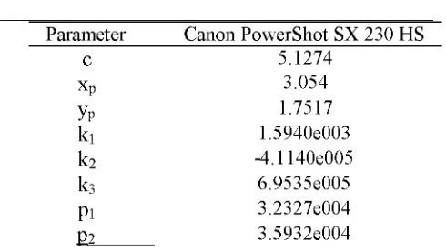
Before a digital camera is used in photogrammetry, it must be calibrated to ensure that the internal geometry of the camera is known. The method of camera calibration used is self calibration bundle adjustment. A camera calibration software was used to calibrate the digital camera. The results of the camera calibration are shown in Table 1. There are 8 parameters in camera calibration, which include focal length, principal point offset, radial, tangential and lens distortion.
Table 1. Result of camera calibration
Parameter Canon PowerShot SX 230 HS
c 5.1274
xp 3.054
yp 1.7517
k1 1.5940e003
k2 -4.1140e005
k3 6.9535e005
pt 3.2327e004
22 3.5932e004
2.2. Equipment
IOP Conf. Series: Earth and Environmental Science 18 (2014) 012032 doi:10.1088/1755-1315/18/1/012032
Figure 1. Hexacopter equipped with Canon PowerShot SX 230 HS.
3. UAV System/Methodology
The Hexacopter uses the autonomous flight control system and controlled by two operators where one act as pilot on ground and the other in charge of monitoring flight mission at ground station. In this experiment, the Hexacopter was equipped with a Canon PowerShot SX 230 HS digital camera in acquiring the simulation model images. The specifications of the Hexacopter UAV are shown in Table 2.
Table 2. Hexacopter UAV Specification
Weight Rotor Endurance Payload GPS on board Special function Stabilizer Capture data Flight control Camera stand
1.2kg 6 rotor
Up to 36 minutes 1kg
Yes
Automatically return to home location (1st point) Inbuilt stabilizer to deal with wind correction Using software to reached waypoints
Manual and autonomous Flexible camera holder
3.1. Fieldwork
The establishment of ground control point (GCP) and check point (CP) was performed after the acquisition of aerial image. The GCP and CP comprise of black and white target points placed throughout the simulation model in order to achieve the maximum effects of relating the measurements derived from the image with the 3D coordinate system. There are 35 GCPs and 6 CPs were established and were located in the simulation model. The 3D coordinates of these GCPs and CPs were determined using total station.
After the camera calibration and the establishment of GCPs and CPs completed, then the aerial images acquisition is carried out using the Hexacopter. For flight planning, the images must be acquired with the specifications coverage of 60% forward lap and 30% sidelap. The digital camera was used to acquire photographs of the simulation model at a constant distance of 3 meter from the model.
3.2 Image Processing
Where;
n = number of checkpoints
X i = True value
X o = Observed value
4. Result and Analysis
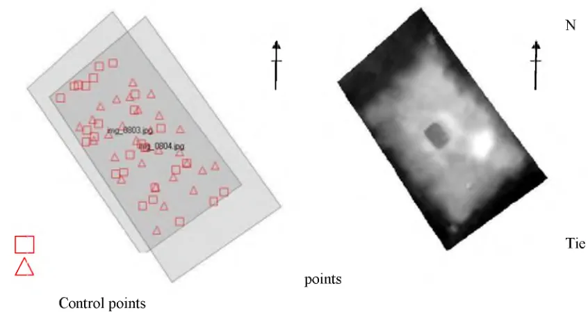
After the process of bundle adjustment or aerial triangulation ad the RMSE value is less than 1.0,the 3D stereo model has successfully been formed. Based on this 3D stereomodel, DTM and orthophoto are produced. The digital photogrammetric software allows user to display footprint of the processed aerial photograph. The footprint consist of two (2) overlapping photograph based on the most efficient and reliable means of providing stereoscopic coverage as shown in Figure 2. The aerial triangulation results shows that the result o f the Canon PowerShot SX 230 HS digital camera is RMSE ± 0.0337. In this preliminary study, two main results were produced i.e DTM as shown in Figure 3 and orthophoto in Figure 3 respectively.
o
(1)
n—1
c
z
pointsN
Tie
Control points
IOP Conf. Series: Earth and Environmental Science 18 (2014) 012032 doi:10.1088/1755-1315/18/1/012032
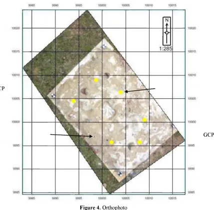
The DTM was produced after aerial triangulation using GCP and later tie points were generated automatically. Then the individual orthophoto for each image was generated from the DTM as shown in Figure 4. Orthophoto product is free from any distortion and demonstrates the whole simulation model.
CP
GCP
Figure 4. Orthophoto
______________________________ Table 3. Comparison of coordinates_________________________
Check Points
~C01 C02 C03 C04 C05 C06
Erdas Imagine Total station Diff. in Coordinates
X(m) Y(m) Z(m) X(m) Y(m) Z(m) AX(m) AY(m) AZ(m)
10010.687 9998.507 20.275 10010.783 9998.575 20.332 -0.096 -0.068 -0.057 10009.475 9999.649 20.190 10009.559 9999.707 20.278 -0.084 -0.058 -0.088 10009.719 9997.949 20.197 10009.782 9997.970 20.262 -0.063 -0.021 -0.065 10010.130 9998.232 20.246 10010.188 9998.319 20.319 -0.058 -0.087 -0.073 10008.896 9999.169 20.154 10008.953 9999.266 20.213 -0.057 -0.097 -0.059 10009.937 9999.477 20.199 10009.962 9999.533 20.314 -0.025 -0.056 -0.115 RMSE 0.171 0.173 0.204
Average 0.183
5. Conclusion
For future work real archaeological site will be determined and the aerial image will be captured using fixed wing UAV. Then the digital images will be processed using similar procedure where the GCPs, CPs and camera calibration parameters will be used for digital processing to produce the photogrammetric product. Then the results from these two platforms will be compared for archaeological site. In this preliminary results show that there is no doubt that good result could be produced from the UAV system using photogrammetric technique.
References
[1] Lin Zong Jian 2008 UAV fo r Mapping-Low Altitude Photogrammetric Survey The International Archives o f the Photogrammetry Remote Sensing and Spatial Information Sciences, Part B1 XXXVII 1183-1186
[2] Witschey W R, and Brown C T 2000 Building a GIS System o f Ancient Lowland Maya Settlement. Society for American Archaeology Annual Meeting
[3] Van Der Leeuw S E 2004 Why Model? Cybernetics and Systems: An International Journal, 35(2-3) pp 117-128
[4] Okabe A 2006 1- Introduction. In A. Okabe, GIS-Based Studies in the Humanities and Social Science (Boca Raton: CRC Press, Taylor & Francis Group) pp 1-18
[5] McPheerron S P, and Dibble H L 2002 Using Computers in Archaeology: Practical Guide (USA: McGraw-Hill Companies)
[6] Lambers K, Eisenbess H, Saurbier M, Kupferschmidt D, Gaisecker T, Sotoodeh S, and Hanusch T 2007 Combining photogrammetry and laser scanning fo r the recording and modeling o f the Late Intermediate Period site o f Pinchango Alto, Palpa, Peru. Journal of Archaeological Science, 34(10): pp 1702-1712
[7] Gerster G, and Trumpler C 2005 The past from above: Aerial photographs o f archaeological sites J. Paul Getty Museum Series (Getty Trust Publications, Los Angeles) [8] J A, Forte M, and Sanders D H 2000 Virtual Reality in Archaeology (ArcheoPress
Oxford) British Archaeological Reports International Series pp 843
Acknowledgements