6
I
January 2018
Transit Oriented Development and Environmental
Impact of Nagpur Metro Rail Project: A Case
Study of Nagpur Metro Alignment-2
Rajesh Bhagat1, Nehal Belwale2, Saurabh Kale3, Vikash Agrawal4, Prashant Dhorabe5, Mangesh Bhorkar6, Yogesh Chintanwar7, Sagar Dhengare8
1, 2, 3, 8 Civil Engineering Department, Yeshwantrao Chavan College of Engg. Nagpur, R.T.M.N.U., Nagpur, India.
4Civil Engineering Department, Priyadarshini College of Engg., Nagpur, R.T.M.N.U., Nagpur, India.
5Civil Engineering Department, Shri Ramdeobaba College of Engg. and Management, Nagpur, R.T.M.N.U., Nagpur, India. 6Civil Engineering Department, G. H. Raisoni College of Engg. Nagpur, R.T.M.N.U., Nagpur, India.
7Civil Engineering Department, Priyadarshini J. L. College of Engg. Nagpur, R.T.M.N.U., Nagpur, India.
Abstract: The growing demand for public transport in cities has serious effects on urban ecosystems, especially due to the increased atmospheric pollution and changes in land use patterns. An appropriate mix of alternative modes of transport is introduced resulting in environmental positive and negative impacts on civilians and land use patterns can be obtained by an ecologically sustainable urban transport system. It is a process of identification, prediction, evaluation, and mitigation of biophysical, social and other relevant effects of developmental activity on environment prior to make commitment. The design standards for universal access to Public Transport Infrastructure including related facilities and services, information, etc. would benefit people using public transport. The study regarding such modern transport system of Metro Rail facility to NAGPUR city is the ultimate aim of this project.
Keywords: Transit Oriented Development, Transit Influence Area, Impact Analysis
I. INTRODUCTION
Nagpur is the third largest city of Maharashtra (India) and also the winter capital of the state, with a population of approximately 25 lakhs. Nagpur Metropolitan Area is the 13th largest urban conglomeration in India. It has also recently been ranked as the cleanest city and the second greenest city of India. In addition to being the seat of annual winter session of Maharashtra state assembly "Vidhan-Sabha", Nagpur is also a major commercial and political center of the Vidarbha region, It is also known as "Orange City" for being a major trade center of oranges that are cultivated in the region.
A. Study Area
In early 2012 Nagpur Improvement Trust (NIT) requested DMRC to provide Consultancy services for preparation of a Detailed Project Report for Metro Rail System in Nagpur, Maharashtra initially for 30 Km which was revised to 42 Km in July 2012. Thereafter, DMRC conducted Traffic Surveys, Topographical Surveys, Geotechnical Investigations and Environment Impact Assessment Survey. The study area consisted of Nagpur Municipal Corporation Area. The study area totaled to approximately 217 sq km. Based on the different types of surveys done by DMRC, metro alignments were finalized after repeated inspection of the road network, intersections, passenger traffic flow, traffic congestion, connectivity to important land uses. Alignments of routes proposed by DMRC were as follow:
TABLE I
ALIGNMENTS PROPOSED BY DMRC(IN JULY 2013)
Alignment-2 East – West Corridor (18.266 Km, 19 stations)
From Prajapati Nagar, along Central Avenue Road, Railway Feeder Road, Munje Chowk, Jhansi Ranee Chowk, North Ambajhari Road, Hingna Road, Lokmanya
Nagar.
Corridor-2: East-West Corridor (Lokmanya Nagar To Prajapati Nagar) The overall capital cost for Corridor-2: at June 2012 price level, works out to Rs. 2984Crore excluding taxes and duties, but including general charges & design charges @ 5% on all items except land and 3% contingencies on all items. Estimated total taxes & duties are Rs. 443Crore.
C. Geographical Conditions
Nagpur lies on the Deccan plateau of the Indian Peninsula and has a mean altitude of 310.5 meters above sea level. The underlying rock strata are covered with alluvial deposits resulting from the flood plain of the Kanhan River. In some places these give rise to granular sandy soil. In low lying areas which are poorly drained, the soil is alluvial clay with poor permeability characteristics. In the eastern part of city crystalline metamorphic rocks such as gneiss, schist and granites are found, while in the northern part yellowish sand stones and clays of the lower Gondwana formations are found.
D. Physiography
Nagpur is situated at 21° 09' N latitude and 79° 09' E longitude and a mean altitude of 310 meters above sea level. Being located far away from any major water body at the centre of the Indian peninsula, the Nagpur's climate is dry or mildly humid for most of the year except for the rainy season. The highest ever recorded temperature in the city was 49 °C, while the lowest was 3°C. The geology of the Nagpur region is famous for the metamorphic rocks, which occur in all the districts in the Nagpur region except Wardha and some part of Nagpur district. The other geological formation Deccan Traps occur in the Wardha and North and North-West part of Nagpur District. It receives an annual rainfall of 1,205 mm (47.44 in) from monsoon rains during June to September. The highest recorded rainfall was 304 mm on 14 July 1994. Summers are extremely hot lasting from March to June, with maximum temperatures occurring in May.
E. Demographics
As per provisional reports of Census India, population of Nagpur in 2011 is 2,405,421; of which male and female are 1,226,610 and 1,178,811 respectively. Although Nagpur city has population of 2,405,421; its urban UA / metropolitan population is 2,497,777 of which 1,275,750 are males and 1,222,027 are females.
TABLE II
CENSUSINDIA,POPULATIONOFNAGPURMETROPOLITANIN2011
Nagpur Metropolitan Total Male Female
Population 2,497,777 1,275,750 1,275,750
Literates 2,095,419 1,102,638 992,781
Children (0-6) 248,678 1,102,638 992,781
Average Literacy (%) 93.17 129,522 119,156
Sex ratio 958 96.20 90.02
Child Sex ratio 920
II. LITERATURE REVIEW
The literature review on Public Transportation system with particular emphasis on planning procedure. Today the cities are residence to half of the world’s population, and in 2030, 60% of the population will live in a city. The urban areas have an increasing importance in our society as they are continually growing, along with all the issues related to theme. Many metro Politian cities in India are facing problem as the ones related to urban transportation, and their interrelated impacts on the environment, economical and society’s are always getting bigger as the cities are growing in their size and populations. Roads and rails respective are first and second largest land consumers and cause several negative consequences such as pollution, subsequent health-related problems, traffic congestion or accidents. Implementing more sustainable transportation systems within human settlements is principal fundamental in order to limit those issues related to transportation. A review on Environmental Impact Assessment of
Construction Projects by Vivek Kumar Tiwari, Anjali Verma, Akash Kumar and Manjul Gupta. Environmental Impact Assessment
words, EIA is an administrative process that identifies the potential environmental effects of any proposal along with its advantages and disadvantages on environment. Positive effects are maximized whereas; adverse effects are minimized to greatest possible extent. “Impact of New Public Transportation System in Nagpur City: A Review” by Narendra M. Hatwar, Prof .V. K. Gajghate. The city will increase their role in the future due to the growth of their dweller, side by side with the increase of their urban issues. Many problems today have their foundation or its bigger share in the cities, thus the cities must be seen as the solutions to these problems. The estimate travel time, Speed before and after introducing public transport in size city through simulation and IRC standards [2]. This Dissertation has investigated a new PT introduction in cities which may lead to sustainable transport and reduce congestion problems in future. “Development of in-vehicle noise prediction models for Mumbai Metropolitan Region, India” by Vishal Konbattulwar, Nagendra R. Velaga, SauravJain,R. B. Sharmila. Road transportation is one of the major sources of noise pollution in urban area. From this study, it was observed that in-vehicle noise pollution was more than 70 dB for 50% of a person's commute. Even when the vehicle is not moving, a person will be exposed to average noise level of more than 67 dB because of vehicle horns, vehicle engine noise, noise due to adjacent vehicles, etc. Intersection area is prone to noise levels above 72 dB in most of the peak hour traffic situations because of heavy traffic and noise due to vehicle horns [3]. “Analysis of Traffic Congestion in Nagpur City” by Shradhesh R. Marve, Mangesh P. Bhorkar. Traffic congestion is a global as well as local problem. All over the world, the major cause of traffic congestion is on street parking of the buses or any other vehicles. By providing the bus bay at an intersection the congestion may be reduced Traffic congestion limitations can be upgraded by implementing various strategies such as road widening, improved road infrastructures, restricting routes for Rickshaw and hawkers, and application of Fly over, in future metro.
III. OBJECTIVES
The primary objective of the study is to evaluate the impact of Nagpur Metro on the current Transit Orientation and on the Environmental factors. The environmental factors are both Positive and Negative. Considering case study of Nagpur Metro Alignment-II, the objectives for the present research are formulated as given below.
A. To study the current road user characteristics for the Transit Influence Area (TIA) along alignment-II of Nagpur Metro. B. To suggest the changes in road use and its policies to increase the density within TIA.
C. To study the Positive and Negative impacts for both Construction and Working phase of Nagpur Metro.
D. To suggest improvement for reducing the Negative impacts of Nagpur Metro for Construction and Working phase.
E. To suggest improvement for enhancing the Positive impacts of Nagpur Metro.
F. To carry out financial feasibility analysis for traffic change for traffic and environment impacts.
IV. DATA COLLECTION
A. Traffic count
Traffic volume studies are conducted to determine the number, movement, and classification of roadway vehicle at a given locations. These are data can help identifies critical flows time period, determine the influence of large vehicle or pedestrian on vehicular traffic flows or document of traffic volume trends. The length of the sampling period depends on the type of count being taken and the intended use of the data recorded.
TABLE III
MOTOR VEHICLES POPULATION IN NAGPUR CITY
Sr. No. Category 31st March, 2011 31st March,2012 31st,March, 2017
1 Motor Cycles 390102 429837 506651
2 Scooters 293926 318999 285412
3 Mopeds 283810 283771 283744
Total No. of Two Wheelers 967838 1032607 1075807
4 Motor Cars 89479 99233 109181
6 Station Wagons 842 842 842
7(A) Taxi meter fitted 0 0 0
7(B) Taxi Tourist Cabs 2661 2907 2891
8 Auto-rickshaws 16417 17149 4805
9 Stage Carriages 1741 1741 1764
10 Contract Carriages 735 899 842
11 School Buses 575 615 752
12 Private service vehicles 1307 1314 1317
13 Ambulances 525 567 639
14 Arti. &Multi.Veh. 896 925 933
15 Trucks & Lorries 12658 13024 15486
16 Tankers 2275 2532 2631
17 Delivery Van (4 Wheelers) 12879 14183 12086
18 Delivery Van (3 wheelers) 6161 6844 4805
19 Tractors 5385 5402 5486
20 Trailers 5263 5348 4076
21 Others 1153 1240 1184
TOTAL 1157034 1237099 1277011
B. Traffic Demand Forecast
To understand traffic characteristics in terms of vehicular, passenger and PCU, 40 traffic count stations were identified, some of which are mid block sections, some locations were fixed as screen line points and some were as outer cordon points.
TABLE IV
DIRECTION WISE PCUTRAFFIC DETAILS AT-NAGPUR ALIGNMENT 2
Loc. No. Loc. Name Direction Traffic PCU Peak PCU Peak Hour
1 Wireless Land Hingna Road E-W Nagpur To Hingna 9,480 685 8.95%
1 Wireless Land Hingna Road W-E Hingna To Nagpur 9,233 638 8.63%
2 Ambazari Tank North E-W Nagpur To Hingna 8,866 717 9.36%
2 Ambazari i Tank North W-E Hingna To Nagpur 8,294 740 10.66%
3 CA Road Near Railway Station E-W Bhandara To Nagpur 14,440 1,074 8.10%
3 CA Road Near Railway Station W-E Nagpur To Bhandara 13,889 1,052 8.12%
4 Rajabaxa Road Central Jail E-W Ajni To Wardha 13,496 1,161 10.01%
4 Rajabaxa Road Central Jail W-E Wardha To Ajni 14,560 1,342 11.22%
5 Wireless – Amravati Road E-W Nagpur To Amravati 12,424 1,356 12.77%
6 Ansari Road – Near Sitabuldi E-W Ganeshpeth To Zero Mile
13,566 1,384 12.60%
6 Ansari Road – Near Sitabuldi W-E Zero Mile to
Ganeshpeth
15,533 1,289 10.20%
7 Old Secretariat – Palm Road E-W Nagpur To Amravati 890 9,614 12.39%
7 Old Secretariat – Palm Road W-E Amravati To Nagpur 6,977 570 9.83%
8 Raisoni College-Hingna Road E-W Nagpur To Hingna 10,347 676 8.40%
8 Raisoni College-Hingna Road W-E Hingna To Nagpur 9,535 719 9.87%
9 Untkhana- Nag Road E-W Ajni To Bhandara 9,953 1,203 10.75%
[image:6.612.33.580.74.602.2]9 Untkhana- Nag Road W-E Bhandara To Ajni 8,773 698 8.59%
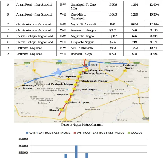
Figure 1: Nagpur Metro Alignment
C. Land Use
The land use/land cover pattern of a region is an outcome of natural and socio –economic factors and their utilization by man in time and space. Hence, information on land use / land cover is essential for the selection, planning and implementation of land use which can be further used to meet the increasing demands for basic human needs and welfare. The different categories of land use of the study region are given in the Table V:
TABLE V
LAND USE CATEGORIES
Sr. No. Land Use Category Area (sq.km) Area Percentage (%)
1 Agricultural Land 11.34 14.52
2 Built-up Area 38.85 49.75
3 Open Area 7.31 9.36
4 Plantation 8.25 10.56
5 Institute 0.51 0.65
6 Industry 6.79 8.70
7 Lake 1.57 2.01
8 Water body 0.42 0.54
9 Canal 0.23 0.29
10 Ground 0.19 0.24
11 Wasteland 2.63 3.37
Total 78.09 100.00
V. IMPACT ANALYSIS
A. Positive Environmental Impacts
1) Employment Opportunities: Manpower will be needed in various activities during construction. In operation, about 45 persons per kilo meter length of the corridor, ie (approx. 1,700 persons) will be employed for operation and maintenance of the proposed system. Thus the project would provide substantial direct employment; besides, more people would be indirectly employed in allied activities and trades.
2) Enhancement of Economy: The construction of Nagpur Metro will facilitate the population to move from one end of the city to another. The proposed transport facility will facilitate rural population to move quickly towards urban centre and return there from. With the development of Nagpur Metro, it is likely that more people will be involved in trade, commerce and allied services
3) Mobility: Metro lines will facilitate people to move quickly towards urban centre and return from there. Any reduction in number of private vehicles will results in reduction of accidents which will involve savings from damage to vehicles and savings towards medical and insurance expenses to persons involved in accidents.
4) Less Fuel Consumption: On implementation of the project both petrol and diesel consumption will get reduced due to shift of passengers from road to rail and also due to decongestion on road.
5) Less Air Pollution: With the construction of metro, there will be less vehicular traffic by road, and consequently less air pollution, and hence the air quality will improve.
6) Reduction in Traffic Congestion: Metro will reduce the congestion and journey time on roads because of diversion of some traffic to Metro. Reduction in traffic congestion will save the necessary capital investment and vehicle operating cost as well as increase in time saving per vehicle.
carrying capacity. The management plan aims at maintaining the environmental quality of project area minimal in pre-project stage. Environmental management strategy/plans were developed to mitigate the adverse impacts.
B. Negative Environmental Impacts
1) Project Affected People (PAPs): The proposed Ahmadabad metro rail project shall cause involuntary displacement of people along the alignment, which shall include both title holder and non-titled holder land owners. The issue of Rehabilitation and Resettlement (R&R) is addressed in a separate SIA report.
2) Change of Land Use: Acquisition of the private land may cause social disruption and economic loss for the project affected families/people. While implementing the project, there is a need to take into account these disturbances and losses due to the project, their impact on socio-economic condition of the people and plan for their mitigation measures to minimize any negative impacts.
TABLE VI
SUMMARY OF PERMANENT LAND REQUIREMENTS
Land Details
East-West Corridor Prajapati Nagar To Lokmanya Nagar North-South Corridor Automotive Square To Khapri Depot
Govt. Land (SqM) Pvt. Land (SqM) Govt. Land (SqM) Pvt. Land (SqM)
Station Exit/Entry 3644.80 7769.40 7525.30 13812.50
Running Section 3255.33 5680.80 101882.00 19025.90
Depot Area 258973.00 339000.00
Traffic Integration/Parking 8779.10 1465.70 53759.80 5179.60
Total 274652.20 14915.90 502167.10 38017.60
Total Govt. Land 776819.30 Say 77.68 Hectares
Total Pvt. Land 52933.50 Say 5.3 Hectares
From the data it could be concluded that out of total permanent land requirement about 94 % land to be acquired is from Government and 6 % from private sector for both corridors. The compensation for land is included in Social Impact Assessment Study Report.
3) Loss of Trees/Forests: The proposed alignment of metro rail is in urban/ city area and not passing through any forest. Hence no loss of forest is anticipated. The trees are getting affected along alignment, stations and at depots location. There are 279 trees observed along the East West alignment and 222 trees are at depot. Hence the total number of trees observed on East-West corridor is 501. These trees which are having girth below 1 meter will be trans-planted and remaining trees from both corridors (i.e 521) of the trees needs to be cut. With removal of these trees the process of CO2 absorption and O2 production will get affected and the losses are reported as follow:
TABLE VII
OXYGEN DEFICIT DUE TO TREE LOSS
Sr. No. Description Quantity
1. Total no. of Trees to be cut 521
2. Increase in CO2 @ 21.8 Kg/year/ tree 11538 kg
3. Decrease in Oxygen production @ 49 Kg/year/ tree 25529 kg
5) Impact on Historical and Cultural Monuments: The proposed metro rail project will affect residential and commercial structures at some of the portion of alignment and metro stations where construction be made by cut and cover method. No Archeological Monuments are directly affected. Utmost care needs be taken so that no significant impact is anticipated on the historical structures due to project activities during construction and operation.
6) Noise Pollution: The cumulative noise on the elevated route alignment will be more than the Noise Standards for Commercial area (National Ambient Noise Standards) of 65db (A) due to the traffic and noise levels from the metro operations.
7) Vibration Impact due to train: The vibration level due to train operation will be in the range 0.062 to 1.0 mm/s. There would be no vibration impact on any structures due to train operation.
C. Impacts Due To Project Design:
1) Platforms Inlets and Outlets: The platform level has adequate assembly space for passengers for both normal operating conditions and a recognized abnormal scenario. The platform level at elevated stations is determined by a critical clearance of 5.50 m under the concourse and above the road intersection. The platforms in an elevated situation at least 12.9m above road level. Tunnel Ventilation fans and ASS in underground stations are provided at platform level/ concourse level depending on availability of land for locating vent shafts.
2) Ventilation and Lighting: The underground stations are built in a confined space. A large number of passengers occupy concourse halls and the platforms, especially at the peak hours. The platform and concourse areas have a limited access from outside and do not have natural ventilation. It is therefore, essential to provide forced ventilation in the stations and inside the tunnel for the purpose of:
a) Supplying fresh air for the physiological needs of passengers and the staff;
b) Removing body heat, obnoxious odours and harmful gases like carbon dioxide exhaled during breathing;
c) Preventing concentration of moisture generated by body sweat and seepage of water in the sub-way;
d) Removing large quantity of heat dissipated by the train equipment like traction motors, braking units, compressors mounted below the under-frame, lights and fans inside the coaches, A/c units etc.;
e) Removing vapour and fumes from the battery
3) Metro Station Refuse: The collection and removal of refuse from railway stations in a sanitary manner is of great importance for effective vector control, nuisance abatement, aesthetic improvement and fire protection. The refuse from railway station includes; Garbage, Rubbish, and Floor Sweepings.
4) Risk Due to Earthquake: The project area lies in Zone III of Bureau of Indian Standards (BIS) Seismic Zoning Map. Seismic factor proposed by India Meteorological Department (IMD) for the purpose of design of Civil Engineering structures shall be incorporated suitably while designing the structures.
D. Impact Due To Project Construction:
1) Soil Erosion: Though the project may not have significant impact on soil erosion, however, minor impact on soil erosion due to runoff from unprotected excavated areas may result in soil erosion, especially when erodibility of soil is high. Problems could arise from dumping of construction soils (concrete, bricks), waste materials (from contractor’ scamp) etc. causing surface and ground water pollution. Mitigation measures include careful planning, timing of cut-and-fill operations and re-vegetation. It is also proposed to have Ready Mix Concrete (RMC) directly from batching plant for use at site. The construction material such as steel, bricks, etc. will be housed in a fenced stored yard. The balance material from store yards will be removed for use/disposal at the end of work.
2) Traffic Diversions: During piling and open foundation work, a width of about 9 m will be required for construction and the same will be barricaded. It is proposed that two lanes are provided for traffic on either side during construction by widening of roads, if necessary. In certain cases, one way traffic may be resorted.
3) Muck Disposal: The proposed metro route is underground for 6.335 km including 4 stations. The construction activity involves tunneling, cut and cover, foundation, fill and embankment. All these activities will generate about 16,03,000 m3 of muck. On land disposal, 40 Ha of area will be required taking an average depth of filling as 4 meter.
TABLE VIIIWATERREQUIREMENTDURINGCONSTRUCTION
Sr. No. Water Requirement Quantity
1 At Labor Camps 63 KLD
2 At Construction site for drinking 20.5 KLD
3 Construction activities 244 KLD
Total 327.50 KLD
5) Loss of Historical and Cultural Monuments: No historical/cultural monuments will be affected/ damaged as a result of the proposed development.
F. Impact Due To Supply of Construction Material
Metro construction is a material intensive activity. Quarry operations are independently regulated activities and outside the purview of the project proponent. It is nonetheless, appropriate to give consideration to the environmental implications in selection of quarry sources since poorly run operations create dust problems, contribute noise pollution, ignore safety of their employees, or cause the loss of natural resources. About 10-15% of the construction material such as waste material from contractor camps is left behind by the contractor as construction waste/spoils. Dumping of construction waste/spoil in haphazard manner may cause surface and ground water pollution near the construction sites.
VI. CONCLUSION
The methods and data used for environmental assessment are insufficient to meet the objectives of rapid assessment, and there are no national standards for data collection. However, tools for in-situ monitoring, remotely sensed monitoring, data compilation, analysis and modeling are continually being improved, and because advances in computer technology practitioners have quick access to tools. The new and improved tools now allow for substantial improvements in environmental assessments.
The proposed Metro line is proved to have significant positive effects to the development of Nagpur City. Benefits to the economy, traffic congestion reduction, quick and safe transport, employment opportunities, fuel consumption reduction, and air quality improvement are the obvious positive effects from this Metro Rail. Appropriate mitigation measures have been developed for potential adverse environmental impacts. With the implementation of the EMP and the environmental monitoring plan, the project is not expected to have significant residual environmental impacts. The city will increase their role in the future due to the growth of their dweller, side by side with the increase of their urban issue. Many problems today have their foundation or its bigger share in the cities, thus the cities must be seen as the solutions to these problems. The estimate travel time, Speed before and after introducing public transport in size city through simulation and IRC standards. This Dissertation has investigated a new PT introduction in cities which may lead to sustainable transport and reduce congestion problems in future.
REFERENCES
[1] “A review on Environmental Impact Assessment of Construction Projects” by Vivek Kumar Tiwari, Anjali Verma, Akash Kumar and Manjul Gupta.
Department of Environment Science, Babashaheb Bhimrao Ambedkar (A Central) University, Lucknow, 226025 Paramarsh Consultancy Service for Environment, Viram Khand 4 H. NO 97 Gomti Nagar, Lucknow.
[2] “Impact of New Public Transportation System in Nagpur City: A Review,” by Narendra M. Hatwar, Prof .V. K. Gajghate. Civil Engineering Department,
M-Tech Transportation G. H. Raisoni College of Engineering Nagpur Maharashtra, India Assistant professor Civil Engineering Department G. H. Raisoni College of Engineering Nagpur Maharashtra, India.
[3] “Development of in-vehicle noise prediction models for Mumbai Metropolitan Region, India,” Vishal Konbattulwar, Nagendra R. Velaga , Saurav Jain , R. B.
Sharmila. Transportation Systems Engineering, Civil Engineering Department, Indian Institute of Technology Bombay, Mumbai 400076, India Civil Engineering Department, Indian Institute of Technology Bombay, Mumbai 400076, India
[4] Sustainable Transportation Systems Linkage between Environmental Issues, Public Transportation, Non-Motorized Transportation and Safety, Economic and
Political Weekly, 1999. Gee tam Tiara.
[5] F. Vanclay, and D. A. Bronstein, Environmental and social impact assessment, New York: Wiley, (1995).
[6] B.A Dutta, and Sengupta, Environmental Impact Assessment (EIA) and Construction, International Research Journal of Environment Science, (2014).
[7] Arrington, G., Cervero, R., 2008, Effects of TOD on Housing, Parking, and Travel. Transit Cooperative Research Program (Report 128)
[8] Cervero, R., 2006, “Public Transport and Sustainable Urbanism: Global lessons” Science Council of Japan, 2006.
[9] City of Ottawa Planning, Transit and the Environment Department, Transit Oriented Guidelines for OTTAWA. Ottawa, 2007.
[10] Clower, T., Ruggiere, P., Bomba, M., Arndt, J., Li, J., Edrington, S., et al., 2011. Evaluating Impact of Transit Oriented Developmet.
[11] A Report on Delhi Metro Rail Corporation, Transit Oriented Development (TOD): Study for Existing Metro Corridor between Chattarpur and Arjangarh of