BIROn - Birkbeck Institutional Research Online
Howard, A.J. and Knight, D. and Coulthard, T. and Hudson-Edwards,
Karen A. and Kossoff, David (2016) Assessing riverine threats to heritage
assets posed by future climate change: a methodological approach based
on understanding geomorphological inheritance and predictive modelling,
tested within the Derwent Valley Mills WHS, UK. Journal of Cultural Heritage
19 , pp. 387-394. ISSN 1296-2074.
Downloaded from:
Usage Guidelines:
Please refer to usage guidelines at or alternatively
Assessing riverine threats to heritage assets posed by future climate change: a
methodological approach based on understanding geomorphological inheritance
and predictive modelling, tested within the Derwent Valley Mills WHS, UK
!
Andy Howard1,2, David Knight3, Tom Coulthard4, Karen Hudson-Edwards5 and David Kossoff5
!
1 Landscape Research Management, Bridgnorth, Shorpshire, UK 2 Department of Archaeology, University of Durham, DE1 3LE, UK 3 York Archaeological Trust, 47 Aldward, York YO1 7BX, UK
4 Department of Geography, Environment and Earth Sciences, University of Hull, Cottingham Road, Hull HU6 7RX, UK
5 Department of Earth and Planetary Sciences, Birkbeck, University of London, Malet St., London WC1E 7HX, UK
!!
1 2 3 4 5 6 7 8 9 10 11 12 13 14 15 16 17 18 19 20 21 22 23 24 25 26 27 28 29 30 31 32 33 34 35 36 37 38 39 40 41 42 43 44 45 46 47 48 49 50 51 52 53 54 55 56 57 58 59 60
Assessing riverine threats to heritage assets posed by future climate change: a
methodological approach based on understanding geomorphological inheritance and predictive modelling, tested within the Derwent Valley Mills World Heritage Site, UK
Key Words: Climate Change; Heritage Management; Environmental Modelling; Derwent Valley Mills
ABSTRACT: Future climate change is likely to pose significant challenges for heritage management, especially in landscape settings such as river valleys as the magnitude,
intensity and nature of geomorphological processes alter in response to changing threshold conditions. Industrial landscapes afford particular challenges for the heritage community, not only because the location of these historic remains is often intimately linked to the physical environment, but also because these landscapes can be heavily polluted by former (industrial) processes and, if released, the legacy of contaminants trapped in floodplain soils and sediments can exacerbate erosion and denudation. Responding to these challenges requires the development of methodologies that consider landscape change beyond individual sites and monuments and this paper reports the development of such an approach based on investigation of the Derwent Valley Mills World Heritage Site,
Derbyshire, UK. Information on geomorphological evolution of the Derwent Valley over the last 1000 years, a time period encompassing the last two periods of major climatic
deterioration, the Medieval Warm Period and Little Ice Age, has been dovetailed with archaeological and geochemical records to assess how the landscape has evolved to past landscape change. However, in addition to assessing past evolution, this methodology uses national climate change scenarios to predict future river change using the CAESAR-Lisflood model. Comparison of the results of this model to the spatial distribution of World Heritage Site assets highlights zones on the valley floor where pro-active mitigation might be
required. The geomorphological and environmental science communities have long used predictive computer modelling to help understand and manage landscapes and this paper highlights an approach and area of research cross-over that would be beneficial for future heritage management.
1 2 3 4 5 6 7 8 9 10 11 12 13 14 15 16 17 18 19 20 21 22 23 24 25 26 27 28 29 30 31 32 33 34 35 36 37 38 39 40 41 42 43 44 45 46 47 48 49 50 51 52 53 54 55 56 57 58 59 1. Introduction
It is now widely acknowledged by the global scientific community that greenhouse gas emissions are causing irrevocable changes to our climate system. Whilst the precise impact of these emissions upon climate remains uncertain, it seems likely that both the frequency and intensity of severe weather events will increase, with extremes of both temperature and rainfall commonplace. These predictions of the nature of change, based upon a combination of empirical data analysis and computer simulation, appear to be confirmed by major news reports from around the globe.
In the UK, the focus of this paper, climate change scenarios [1] provide an insightful backdrop to the major river flood events recorded at Boscastle (Devon) in summer 2004 [2], nationwide in summer 2007 [3], at Cockermouth (Cumbria) in autumn of 2009 [4] and nationwide in the autumn and winter of 2013-2014 [5-8]. Of course, weather conditions alone cannot be held responsible for the severity of these events, with physiography, antecedent conditions, landscape and current flood mitigation measures, all affecting response to individual storms. These exacerbating factors have been termed ‘risk multipliers’ [9].
Economically, the cost of floods in the UK is substantial; for example, the summer floods of 2007 resulted in a bill of around £3 billion (http://www.floodfreehomes.org.uk). However, the social, environmental and political impact of flooding is equally as significant [10]. Within our communities, the Historic Environment plays a unique role in economic generation (e.g. sustainable tourism), social/cultural cohesion and well-being, and over the last decade there has been a growing awareness of the potential impact of climate change upon these assets, both in the UK [11-17] and globally [18-23].
Within the Northern and Western parts of the UK, some of the landscapes and heritage assets most vulnerable to climate change are those associated with the ‘Industrial Revolution’ (considered for the purposes of this paper, the 18th and 19th centuries). During this period of rapid industrial and economic growth, industry exploited natural resources, including coal, limestone and metal ores and used water for power; however, paradoxically, many of these advantageous physiographic and geological characteristics essential to industrial development are also environments where geomorphological processes are most sensitive to climatic change. Furthermore, many of these regions, particularly those specifically associated with historic metal mining, have a legacy of pollution now trapped in floodplain soils and sediments [24-27]. Empirical evidence has shown that the release of large volumes of fine-grained sediment and toxic contaminants during periods of increased flood frequency and magnitude caused a significant number of rivers in the Northern Pennines (North Yorkshire, County Durham and Northumberland) to transform from single to multi-channelled braided systems during the Little Ice Age [28], the last period of major climatic deterioration.
1 2 3 4 5 6 7 8 9 10 11 12 13 14 15 16 17 18 19 20 21 22 23 24 25 26 27 28 29 30 31 32 33 34 35 36 37 38 39 40 41 42 43 44 45 46 47 48 49 50 51 52 53 54 55 56 57 58 59 60
This paper focuses on the development of such a methodology evaluated within the Derwent Valley Mills World Heritage Site (hereafter, DVMWHS), situated along a 24km stretch of the River Derwent, Derbyshire, UK. This novel, interdisciplinary approach utilises information on past landscape history reconstructed using a variety of archaeological, geochemical and geomorphological records, coupled with computer modelling of future river development. These results are compared against the spatial distribution of assets of the World Heritage Site and used to flag key factors of concern for heritage and environmental managers.
2. The Character of the Derwent Valley Mills World Heritage Site
The River Derwent has a catchment area of around 1200km2. It originates some 9km east of Glossop at an elevation of 590m OD on the high moorland of the Peak District National Park and flows south, encountering the northern boundary of the DVMHWS at the downstream limit of the dramatic incised gorge at Matlock Bath (Fig. 1). The DVMWHS was inscribed in 2001 and encompasses a series of 18th and 19th century cotton mills recording the birth of the modern factory system, together with its associated infrastructure including workers housing, schools, churches and model farms [29].
For most of the length of the World Heritage Site, the River Derwent cuts through complexly folded and faulted mudstones, shales, siltstones and sandstones of Carboniferous age, although at its southern end, it cuts through mudstones, siltstones and sandstones of Permo-Triassic age. Despite being a sizeable river, it is constrained within a relatively narrow valley floor (maximum width of 500m), which has prevented the preservation of laterally extensive river terraces along its valley sides; instead, fragmentary remnants have been preserved.
The mills themselves required water for power and are therefore situated on the contemporary floodplain, immediately adjacent to the channel and associated with elaborate systems of weirs and sluices, which maintained a head of water (Fig. 2). In contrast, the infrastructure associated with milling (e.g. housing, schools) were situated on the higher terrace fragments, enlarging hamlets and villages to create small towns such as Belper. As well as activity directly associated with milling, much of the surrounding landscape was owned by the industrialists and became the focus of agricultural innovation, particularly through the development of ‘Model Farms’ [30-31], creating an even richer supplementary legacy of post-medieval archaeological remains.
1 2 3 4 5 6 7 8 9 10 11 12 13 14 15 16 17 18 19 20 21 22 23 24 25 26 27 28 29 30 31 32 33 34 35 36 37 38 39 40 41 42 43 44 45 46 47 48 49 50 51 52 53 54 55 56 57 58 59 3. Methodology
To provide a tight research focus, the project area was restricted to the established boundaries of the DVMWHS core zone (1,229 hectares) and buffer zone (4363 hectares), as defined in the site designation and inscription (http://whc.unesco.org/en/list/1030) (see Fig. 1). Inclusion of the buffer zone was deemed crucial to methodological development since much of this area includes abandoned mine workings and areas of slope instability, which may be influential in supplying contaminated sediments to the valley floor.
Geoarchaeological evolution of the valley floor over the last 1000 years was selected as the timescale of study, since this period includes the major climatic anomalies of the Medieval Warm Period and Little Ice Age. To elucidate geomorphological development of the valley floor, landform assemblages (river terraces, palaeochannels, ridge and swale topography) were identified and mapped from aerial photographs and lidar with additional information provided by historic maps and published literature. Information on the geochemical and contamination history of the region was collated from mine records, published literature, unpublished doctoral theses and the holdings of the British Geological Survey. Historic Environment Records (HER) for the medieval, post-medieval and modern periods provided information on the location and interpretation of heritage assets, although the analysis of lidar mapping identified a number of additional archaeological features unrecorded by the HER. Further information on each data source is provided in Table 1 as well as in the full project report [34]. The capture of all of these data within the project GIS (QGIS version 2.6 Brighton) allowed landscape evolution to be compared with the location of heritage assets to assess the hazards posed to these remains based on historic natural processes.
1 2 3 4 5 6 7 8 9 10 11 12 13 14 15 16 17 18 19 20 21 22 23 24 25 26 27 28 29 30 31 32 33 34 35 36 37 38 39 40 41 42 43 44 45 46 47 48 49 50 51 52 53 54 55 56 57 58 59 60 4. Results
4.1. Landscape evolution during the last millennium and the archaeological record
Table 2 provides a summary of the geological characteristics of the DVMWHS and an assessment, based on empirical evidence, of how the landscape has evolved over the last millennium and the potential implications for its heritage assets. It is clear that upstream of Milford, channel mobility has been limited, but downstream of this point, palaeochannels with dimensions akin to the contemporary channel indicate that the river has moved across its floodplain, though Ordnance Survey historic mapping suggests that this was before AD 1820-1830. Ridge and Swale topography suggests that at least some of this movement was through lateral migration. Whilst flooding has been historically important, particularly during the climatic deterioration of the Little Ice Age, the regulation of the Derwent, which was completed by 1943, has lessened the impact of such high magnitude events on the contemporary catchment. Notably, there are a series of reservoirs constructed in the main headwater tributaries for water supply that also reduce peak flows. However, the increasing intensity of storms under scenarios of climate change may require the controlled release of more water from reservoirs during such events, while not resulting in catastrophic floods, may well lead to some erosion of the floodplain. A review of the geochemical data has demonstrated that the floodplain alluvium is heavily contaminated with metals reworked from mine sites and any disturbance of these sediments may result in complex change of the floodplain, depending on the character of contaminant redistribution [45] as well as mobilising material which may impact on the fabric of built assets [46]. Furthermore, the blanket peats in the upland headwaters of the catchment contain a significant legacy of metal pollutants deposited historically through atmospheric fallout from industrial sources in the surrounding conurbations [47]; again, these have the potential to be remobilised through the riparian system, augmenting the supply of contaminants already in the fluvial system.
1 2 3 4 5 6 7 8 9 10 11 12 13 14 15 16 17 18 19 20 21 22 23 24 25 26 27 28 29 30 31 32 33 34 35 36 37 38 39 40 41 42 43 44 45 46 47 48 49 50 51 52 53 54 55 56 57 58 59
interpret the climatic downturn of the Little Ice Age as a driver for enhanced fluvial activity and the truncation of blocks of floodplain ridge and furrow.
4.2. Modelling future landscape change and its impact on historic assets
Evidence from landform assemblages demonstrates that the River Derwent has been mobile within the valley floor during the last millennium, though this mobility precedes the earliest Ordnance Survey maps of 1820-1830, which demonstrate that the channel has been stable for around 180 years. Furthermore, computer simulations of contemporary hydrological conditions suggest that the flow regime poses little threat to the historic remains of the DVMWHS, and it seems likely that surface water flooding poses a more immediate risk.
However, a key part of the developed methodology was to use the CAESAR-Lisflood model to predict future channel change and flood events under predicted rainfall patterns under climate change scenarios. Future rainfall was simulated using the UKCP09 Weather Generator, with the high emissions scenario for the time period 2020-2049. The weather generator produced 100, 30-year hourly rainfall simulations for the catchment above the DVMWHSB reach. From these 100 simulations, 20 were randomly selected and used to generate 30-year periods of flows to drive future erosion and deposition patterns within the DVMWHS reach itself. The results of this modelling suggest that there should be minimal problems with sedimentation or erosion in response to changing flood patterns up to 2050, assuming that current valley floor and channel characteristics are not altered significantly, for example, by the implementation of new flood protection measures and associated engineering. In general, the results of the future climate change scenarios suggest that the present channel pattern will remain relatively stable, with generally low levels of lateral erosion, and that metal contaminants bound within the alluvium of the wider floodplain will not be remobilised significantly. Given that there is little likelihood of significant changes in the overall channel shape of the channel or shifts in its position, there will be little change in the areas affected by flood events of the same size as are recorded today, but the larger flood events that may be suggested on the basis of current climate change models may well inundate areas that are at present rarely if at all flooded.
1 2 3 4 5 6 7 8 9 10 11 12 13 14 15 16 17 18 19 20 21 22 23 24 25 26 27 28 29 30 31 32 33 34 35 36 37 38 39 40 41 42 43 44 45 46 47 48 49 50 51 52 53 54 55 56 57 58 59 60
used to inform future management practices with the DWHWHS or in other areas where applied.
5. Conclusions
Recent papers have highlighted the challenges faced by heritage assets in the light of future climate change and the need for site managers and historic environment custodians to have access to robust datasets and specialist information to guide decision making and the implementation of adaptation strategies [49-50]. Within the discreet context of World Heritage Sites, UNESCO now requires all individual designations to prepare and implement assessment plans for climate change. However, preparation of such strategies and informed decision making requires a baseline assessment and understanding of the threats to the resource, and one which looks beyond the immediate historic asset and considers it within a wider landscape context. This paper provides a methodological template for investigating past natural landscape development using a variety of geomorphological, palaeoenvironmental, geochemical and cultural archaeological datasets in order to provide a contextual framework for mitigating the impacts of future climate change. However, the methodology goes further by exploring future landscape development, in this example within a river valley floor, by using computer modelling to simulate channel change and demonstrates the application of an approach, yet to be used widely within the field of heritage management, despite being regularly used by fluvial geomorphologists and river engineers for over two decade.
It is envisaged that the approach outlined in this paper, dovetailing empirical and modelled data, could be applied to other river valleys in a variety of climatic settings beyond the temperate zone, providing that proxy environmental records and landform assemblages are preserved, which will allow reconstruction and assessment of landscape evolution. Furthermore, if past geomorphological processes can be identified, information gleaned from these sources allows for the modelling of future conditions and calibration of results. Whilst this example has been focused on historic assets assigned World Heritage status, the approach could be applied across the stratum of heritage remains.
Acknowledgements
1 2 3 4 5 6 7 8 9 10 11 12 13 14 15 16 17 18 19 20 21 22 23 24 25 26 27 28 29 30 31 32 33 34 35 36 37 38 39 40 41 42 43 44 45 46 47 48 49 50 51 52 53 54 55 56 57 58 59
1 2 3 4 5 6 7 8 9 10 11 12 13 14 15 16 17 18 19 20 21 22 23 24 25 26 27 28 29 30 31 32 33 34 35 36 37 38 39 40 41 42 43 44 45 46 47 48 49 50 51 52 53 54 55 56 57 58 59 60 References
[1] G. Jenkins, J. Murphy, D. Sexton, J. Lowe, P. Jones, C. Kilsby. UK Climate Projections: Briefing report. Version 2 (2010). http://ukclimateprojections.defra.gov.uk
[2] S. Burt, Cloudburst upon Hendraburnick Down: The Boscastle Storm of 16 August 2004, Weather 60 (2005) 219-227.
[3] M. Pitt, Learning lessons from the 2007 floods. An independent review by Sir Michael Pitt. The Pitt Review, Cabinet Office, London, 2008.
[4] S. Sibley, Analysis of extreme rainfall and flooding in Cumbria 18–20 November 2009, Weather 65 (2010) 287-292.
[5] K. Dodds, Après le deluge: the UK winter storms of 2013-14, The Geographical Journal 180 (2014) 294–296.
[6] C. Huntingford, T. Marsh, A.A. Scaife, E.J. Kendon,, J. Hannaford, A.L. Kay, M. Lockwood, C. Prudhomme, N.S. Reynard, S. Parry, J.A. Lowe, J.A. Screen, H.C. Ward, M. Roberts, P.A. Stott, V.A. Bell, M. Bailey, A. Jenkins, T. Legg, F.E.L. Otto, N. Massey, N. Schaller, J. Slingo, M.R. Allen, Potential influences on the United Kingdom’s floods of winter 2013/14, Nature Climate Change 4 (2014) 769–777.
[7] E. Stephens E, H. Cloke, Improving flood forecasts for better flood preparedness in the UK (and beyond), The Geographical Journal 180 (2014) 310-316.
[8] C. Thorne, Geographies of UK flooding in 2013/4, The Geographical Journal 180 (2014) 297–309.
[9] A. Croft, Assessment of Heritage at Risk from Environmental Threat. Key Messages Report for English Heritage. Atkins Heritage, Birmingham, 2013.
[10] M. Pitt, Learning lessons from the 2007 floods. An independent review by Sir Michael Pitt. The Pitt Review, Cabinet Office, London, 2008.
[11] M. Cassar, Climate Change and the Historic Environment, Centre for Sustainable Heritage, University College London, 2005.
[12] English Heritage, Climate Change and the Historic Environment, English Heritage, Swindon, 2006.
[13] A.J. Howard, K. Challis, J. Holden, M. Kincey, D.G. Passmore, The impact of climate change on archaeological resources in Britain: a catchment scale assessment, Climatic Change 91 (2008), 405-422.
1 2 3 4 5 6 7 8 9 10 11 12 13 14 15 16 17 18 19 20 21 22 23 24 25 26 27 28 29 30 31 32 33 34 35 36 37 38 39 40 41 42 43 44 45 46 47 48 49 50 51 52 53 54 55 56 57 58 59
[15] P. Murphy, D. Thackray, E. Wilson, Coastal heritage and climate change in England. Assessing threats and priorities, Conservation & Management of Archaeological Sites 11 (2009) 97-115.
[16] English Heritage, Flooding and Historic Buildings, 2nd Edition, English Heritage, Swindon, 2010.
[17] A. Croft, Assessment of Heritage at Risk from Environmental Threat. Key Messages Report for English Heritage. Atkins Heritage, Birmingham, 2013.
[18] S.G. Lanza, Flood hazard threat on cultural heritage in the town of Genoa (Italy), Journal of Cultural Heritage 4 (2003) 159-167.
[19] A. Colette, Case Studies on Climate Change and World Heritage, UNESCO, Paris, 2007.
[20] UNESCO, Policy document on the Impacts of Climate Change on World Heritage Properties, UNESCO, Paris, 2008.
[21] K. Daly, Climate change and the conservation of archaeological sites: a review of impacts theory, Conservation and Management of Archaeological Sites 13 (2011) 293-310.
[22] B. Marzeion, A. Levermann, Loss of cultural world heritage and currently inhabited places to sea-level rise. Environmental Research Letters 9 (2014) 1-7.
[23] J-J Wang, Flood risk maps to cultural heritage: measures and processes, Journal of Cultural Heritage 16 (2014) 210-220.
[24] B.E. Davies, J. Lewin, Chronosequences in alluvial soils with special reference to historical pollution in Cardiganshire, Wales, Environmental Pollution 6 (1974), 49–57.
[25] J. Lewin, M.G. Macklin, Metal mining and floodplain sedimentation in Britain, In: V. Gardiner (Ed.), International Geomorphology 1986 Part 1. Wiley, Chichester, 1987, pp. 1009–1027.
[26] K.A. Hudson-Edwards, M.G. Macklin, M.P. Taylor, 2000 years of sediment borne heavy metal storage in the Yorkshire Ouse basin, NE England, UK, Hydrological Processes 13 (1999) 1087-1102.
[27] S.A. Foulds, P.A. Brewer, M.G. Macklin, W. Haresign, R.E. Betson, S,M.E Rassner, Flood related contamination in catchments affected by historical metal mining: an emerging hazard of climate change, Science of the Total Environment 476-477 (2014) 165-180.
[28] M.G. Macklin, B.T. Rumsby, M.D., Historical floods and vertical accretion of fine-grained alluvium in the lower Tyne valley, northeast England, in: P. Billi, R.D. Hey, C.R. Thorne, P. Tacconi (Eds.), Dynamics of Gravel-Bed Rivers, Wiley, New York (1992), pp. 573-589.
1 2 3 4 5 6 7 8 9 10 11 12 13 14 15 16 17 18 19 20 21 22 23 24 25 26 27 28 29 30 31 32 33 34 35 36 37 38 39 40 41 42 43 44 45 46 47 48 49 50 51 52 53 54 55 56 57 58 59 60
[30] W.S. Wade, The English Model Farm: Building the Agricultural Ideal, 1700-1914, Windgather Press, Macclesfield, 2002.
[31] W.S. Wade, A. Menuge, A. Storer, The Strutt farms of the Derwent Valley, Derbyshire, Journal of the Historic Farm Buildings Group 17 (2003) 11-35.
[32] S.P. Bradley, J.J. Cox, The significance of the floodplain to the cycling of metals in the River Derwent catchment, UK, The Science of the Total Environment 97/98 (1990) 441-454.
[33] S.A. Foulds, M.G. Macklin, P.A. Brewer, Agro-industrial alluvium in the Swale catchment, northern England, as an event marker for the Anthropocene, The Holocene 23 (2013) 587-602.
[34] A.J. Howard, D. Knight, Future Climate and Environmental Change within the Derwent Valley Mills World Heritage Site, Unpublished report for English Heritage, Landscape Research & Management and York Archaeological Trust, 2015.
[35] T.J. Coulthard, M.J. Van De Wiel, Numerical Modeling in Fluvial Geomorphology, in Treatise on Geomorphology 9.34 (2013) 694–710.
[36] G.E. Tucker, G.R. Hancock, Modelling landscape evolution, Earth Surface Processes and Landforms 35 (2010) 28–50.
[37] M.J. Van De Wiel, T.J. Coulthard, M.G. Macklin, J. Lewin, Modelling the response of river systems to environmental change: Progress, problems and prospects for palaeo-environmental reconstructions, Earth-Science Reviews 104 (2011) 167–185.
[38] Q. Clevis, G.E. Tucker, G. Lock, S.T. Lancaster, N. Gasparini, A. Desitter, R.L. Brass, Geoarchaeological simulation of meandering river deposits and settlement distributions: A three-dimensional approach, Geoarchaeology 21 (2006) 843-874.
[39] T.J. Coulthard, J.C. Neal, P.D. Bates, J. Ramirez, G.A.M. de Almeida, G.R. Hancock, Integrating the LISFLOOD-FP 2D hydrodynamic model with the CAESAR model: Implications for modelling landscape evolution, Earth Surface Processes and Landforms 38 (2013) 1897-1906.
[40] T.J. Coulthard, M.J. Kirkby, M.G. Macklin, Modelling geomorphic response to environmental change in an upland catchment, Hydrological processes 14 (2000) 2031-2045.
[41] T.J. Coulthard, M.J. Van De Wiel, Modelling river history and evolution, Philosophical Transactions of the Royal Society A: Mathematical, Physical and Engineering Sciences 370 (2012) 2123-2142.
1 2 3 4 5 6 7 8 9 10 11 12 13 14 15 16 17 18 19 20 21 22 23 24 25 26 27 28 29 30 31 32 33 34 35 36 37 38 39 40 41 42 43 44 45 46 47 48 49 50 51 52 53 54 55 56 57 58 59
[43] G.R. Hancock, T.J. Coulthard, C. Martinez, J.D. Kalma, An evaluation of landscape evolution models to simulate decadal and centennial scale soil erosion in grassland catchments, Journal of Hydrology 308 (2011) 171-183.
[44] K.E. Welsh, J.A. Dearing, R.C. Chiverrell, T.J. Coulthard, Testing a cellular modelling approach to simulating late-Holocene sediment and water transfer from catchment to lake in the French Alps since 1826, The Holocene 19 (2009) 785–798.
[45] J. Lewin, M.G. Macklin, Metal mining and floodplain sedimentation in Britain, In: V. Gardiner (Ed.), International Geomorphology 1986 Part 1. Wiley, Chichester, 1987, pp. 1009–1027.
[46] I.A. Dennis, M.G. Macklin, T.J. Coulthard, P.A. Brewer, The impact of the October– November 2000 floods on contaminant metal dispersal in the River Swale catchment, North Yorkshire, UK, Hydrological Processes 17(2003) 1641-1657.
[47] J.J. Rothwell, S.G. Robinson, M.G. Evans, J. Yang, T.E.H Allott, Heavy metal release by peat erosion in the Peak District, southern Pennines, UK, Hydrological Processes 19 (2005) 2973-2989.
[48] L. Elliott, H. Jones, A.J. Howard, The medieval landscape, in: D. Knight and A.J. Howard (Eds) Trent Valley Landscapes, Heritage Marketing and Publications Ltd, Kings Lynn (2004), pp 153-191.
[49] H. Phillips, Adaptation to climate change at UK World Heritage Sites: progress and challenges, The Historic Environment 5 (2014) 288-299.
1 2 3 4 5 6 7 8 9 10 11 12 13 14 15 16 17 18 19 20 21 22 23 24 25 26 27 28 29 30 31 32 33 34 35 36 37 38 39 40 41 42 43 44 45 46 47 48 49 50 51 52 53 54 55 56 57 58 59 60
List Figures
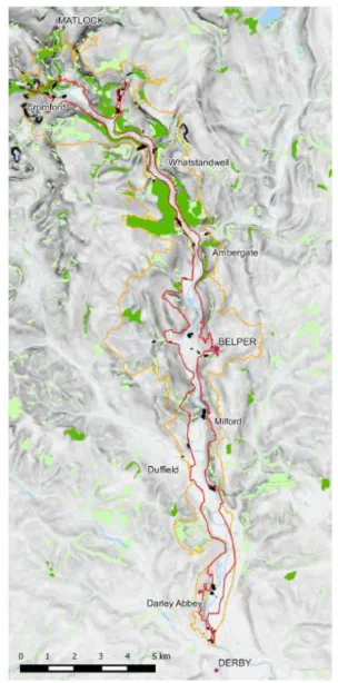
Fig 1. The Derwent Valley Mills World Heritage Site. The core site is shown in red, whilst the extent of the buffer zone is denoted by the brown line
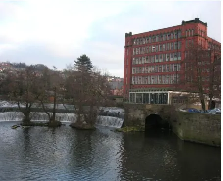
Fig 2. East Mill, Belper and its associated horse shaped weir. An example of the historic assets of the World Heritage Site.
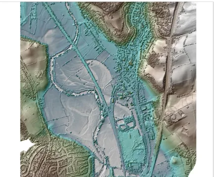
Fig. 3. Lidar derived image showing part of the Derwent valley floor below Milford illustrating the dynamic nature of past river activity and its impact on earthwork remains (ridge and furrow). Source data © Environment Agency.
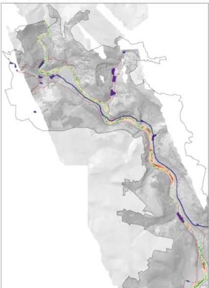
Fig 4A. Modelling of sediment erosion (red) and deposition (green) in relation to HER assets (blue) in the upper part of the study area (source data © Environment Agency).
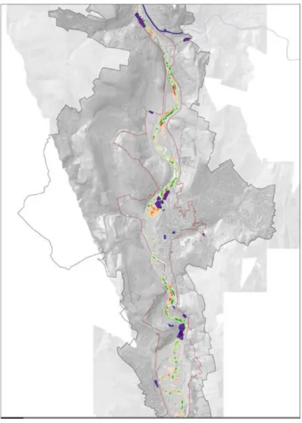
Fig 4B. Modelling of sediment erosion (red) and deposition (green) in relation to HER assets (blue) in the middle part of the study area (source data © Environment Agency)
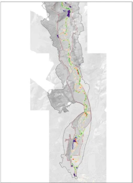
Fig 4C. Modelling of sediment erosion (red) and deposition (green) in relation to HER assets (blue) in the lower part of the study area (source data © Environment Agency).
1 2 3 4 5 6 7 8 9 10 11 12 13 14 15 16 17 18 19 20 21 22 23 24 25 26 27 28 29 30 31 32 33 34 35 36 37 38 39 40 41 42 43 44 45 46 47 48 49 50 51 52 53 54 55 56 57 58 59
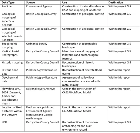
Table 1. Data collected by the project
Data Type Source Use Destination
2m lidar Environment Agency Construction of natural landscape DSM and mapping of landforms
Within project GIS
Geological mapping of superficial deposits
British Geological Survey Construction of geological context Within project GIS
Geological mapping of selected hazards (landslips)
British Geological Survey Construction of geological context Within project GIS
Topographic mapping
Ordnance Survey Construction of topographic landscape
Within project GIS
Vertical Aerial Photographs
Derbyshire County Council Identification and mapping of landforms and archaeological features
Within project GIS
Historic mapping Derbyshire County Council Reconstruction of historic landscapes
Within project GIS
Historic flood data
Published/grey literature Reconstruction of discrete flood events
Within this report
Geochemical data
Published/grey literature Assessment of valley floor contamination associated with metal mining
Within this report
Flow data 1971-2004 (Derwent, Amber and Ecclesbourne rivers)
National Rivers Archive Used in the construction of CAESAR-Lisflood Model
Within this report
Location of fixed obstacles within the Derwent
Field survey, published Environment Agency literature and Google earth images
Used in the construction of CAESAR-Lisflood Model
Within this report
HER Derbyshire County Council Reconstruction of the known archaeological and built environment record
1 2 3 4 5 6 7 8 9 10 11 12 13 14 15 16 17 18 19 20 21 22 23 24 25 26 27 28 29 30 31 32 33 34 35 36 37 38 39 40 41 42 43 44
Table 2. Natural landscape characteristics of the DVMWHS and implications for heritage assets
Empirical Evidence Summary of Evidence in WHS Implications for WHS Heritage Assets
Bedrock geology mapping. Carboniferous mudstones, siltstones and sandstones that crop out over the majority of the area are complexly folded and faulted and form alternating beds that are prone to slope failure.
Carboniferous limestones that crop out in the north of the area are host rock metalliferous ores that have been extensively mined.
Permo-Triassic mudstones and siltstones crop out in the southern part of the study area.
Slope failure of Carboniferous mudstones, siltstones and sandstones may introduce significant quantities of superficial sediments into the valley floor, some of which may be contaminated by heavy metals if close to mine sites.
Subsidence associated with mass movement may impact on the stability of buildings.
Mines shafts, adits and spoil heaps within the limestone area may include unconsolidated ore remnants and polluted waste materials capable of remobilisation
Quaternary geology mapping and landform assemblages
Narrow valley floor has prevented extensive river terrace development and where preserved, terraces are fragmentary.
Periglacial slope deposits forms apron of sediment along the valley sides and are often closely associated with river terrace remnants.
Some of the periglacial material may reflect post-glacial colluvial processes.
Alluvium covers the contemporary floodplain.
Upstream of Milford, palaeochannels are poorly developed in valley floor (<100m wide) and where preserved, they form simple, linear features close to the modern channel. South of Milford, the valley floor is wider (around 500m) and palaeochannels are well developed and divisible into two types: (1) major sinuous channels with wavelength amplitudes and dimensions similar to the modern channel; (2) minor distributaries irregularly scattered across the floodplain surface.
Minor, curved features in parallel groups are indicative of ridge and swale topography.
Wider infrastructure associated with the mills concentrated on terrace features.
Colluvium may have reworked archaeological material from the surrounding valley slopes and redeposited material on the floodplain or mask remains at the floodplain edge.
Alluviation may burial archaeological remains on the floodplain.
Palaeochannels upstream of Milford suggest limited past mobility of the river within the valley floor and where change has occurred it has been close to the contemporary channel. Downstream of Milford, the floodplain is wider and has allowed greater channel mobility demonstrating the ability of the river to migrate in this region.
1 2 3 4 5 6 7 8 9 10 11 12 13 14 15 16 17 18 19 20 21 22 23 24 25 26 27 28 29 30 31 32 33 34 35 36 37 38 39 40 41 42 43
Historic mapping. Early Ordnance Survey mapping (c. AD 1850) mapping suggests little
variation in river pattern or channel position over the last c.150 years. Mapping suggests the limited river movement during the last c. 150 years. This suggests that palaeochannels observed south of Milford predate c. AD 1850.
Documented floods. AD 1066-1539 - 10 major floods recorded
AD 1540-1900 – 31 major floods recorded
AD 1901-1940 – 5 major floods recorded*
* This final period is problematic since reservoirs were constructed and completed in the upper Derwent Valley in 1912 (Howden) and 1914 (Derwent), although it was not until the completion of Lady Bower Reservoir in 1943 that total flood regulation of the catchment was achieved
Documentary evidence suggests that severe floods have affected the Derwent valley during the last millennium, a finding that agrees with other national records (Macklin et al., 2005; 2010; 2012), but that regulation of the river through reservoir construction in the past century has reduced their severity. However, changing weather patterns may impact on regulation practices (e.g. more release of water from the reservoirs), which may not result in high magnitude flood events but may change the hydrological response through time.
Geochemical history. Floodplain alluvium and soils are heavily contaminated by metal-pollutants reworked directly from mine tailings and processing areas on the valley sides and contain levels well above national guideline for contaminated land (Table 3).
Contaminants may be particularly concentrated where sediment thicknesses are enhanced within the system, for example, immediately upstream of weir systems.
Upland areas of blanket peat moorland contain high levels of metal pollutants deposited through (historic) atmospheric fallout from (historic) industrial sources.
Potential for remobilisation of contaminants within the valley floor resulting in degradation of the riparian environment (e.g. devegetation and increased channel bank erosion) and increased human exposure both directly and via the food chain.
Fig 1. The Derwent Valley Mills World Heritage Site. The core site is shown in red, whilst the extent of the buffer zone is denoted by the brown line.
Fig. 2. East Mill, Belper and its associated horse shaped weir. An example of the historic assets of the WHS.
Fig. 3. Lidar derived image showing part of the Derwent valley floor below Milford illustrating the dynamic nature of past river activity and its impact on earthwork remains (ridge and furrow). Source data © Environment Agency.
Fig 4A. Modelling of sediment erosion (red) and deposition (green) in relation to HER assets (blue) in the upper part of the study area (source data © Environment Agency)
Fig 4b. Modelling of sediment erosion (red) and deposition (green) in relation to HER assets (blue) in the middle part of the study area (source data © Environment Agency)
Fig 4c. Modelling of sediment erosion (red) and deposition (green) in relation to HER assets (blue) in the lower part of the study area (source data © Environment Agency)
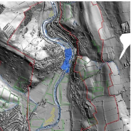
Fig. 5. Processed lidar image showing palaeochannels, ridge and furrow and other earthworks on the valley floor where it widens immediately downstream of Milford. The historic assets of the Milford mill complex are shaded blue, palaeochannels are outlined in yellow and HER polygons are outlined in green. Source data © Environment Agency.