2019 International Conference on Information Technology, Electrical and Electronic Engineering (ITEEE 2019) ISBN: 978-1-60595-606-0
3D Rapid Modeling and Key Technology Analysis of Mountain Tunnel
Qiang SHI
*, Xu LIU, Qiang LIU and
Hong-hao WAN
North-West Institute of Nuclear Technology, Xi’an, 710024, Shaanxi, China*Corresponding author
Keywords: Tunnel, Modelling, 3DMAX, Construction.
Abstract. With the progress and development of science and technology, two-dimensional information display mode cannot meet the needs of information acquisition, three-dimensional information display mode has become the mainstream development direction of information display. Rock mass tunnel is a kind of structure body that crosses the obstacle of mountain body. Because its construction environment is in mountain body, it is not convenient for design and construction personnel to observe the construction situation and the development of tunnel at any time. Therefore, 3D MAX modeling for dynamic demonstration of tunnel space can better guide the design and construction, feedback the information from the site to the staff in time, and achieve the purpose of information design and construction. The paper comprehensively expounds the technical process of 3D modeling of tunnel structures based on 3D MAX modeling software, and deeply discusses the key technical problems. The 3D MAX based rock mass tunnel modeling is dissected through actual cases.
Introduction
3D MAX is a 3D software of Autodesk Company. In 3D modeling, 3D MAX has a cross-era significance. It has a very powerful modeling, material, lighting, rendering system, can easily create a variety of models and animation, and relatively simple operation, widely used in advertising, film and television, industrial design, architectural design, auxiliary teaching and engineering visualization and other fields [1]. Three-dimensional modeling technology has been developed in China for more than 30 years, especially in the past few years, such as panoramic map, virtual reality, Internet of things and other high-tech applications in the field of architecture, but also for the application of three-dimensional modeling technology opened up another world. Because of the powerful modeling function of 3D MAX software, its application in engineering field is more and more extensive.
With the rapid development of transportation industry in China in recent years, tunnel excavation is becoming more and more common. Because the tunnel will be faced with various problems in the excavation process, at the same time, the country pays more and more attention to the safety of tunnel excavation, traditional static pictures, CAD design drawings, documents and other forms exist: poor visual effect, poor interaction and other shortcomings, has not been able to meet the growing size and complexity of tunnel projects [2]. With the popularization and application of 3D modeling technology in engineering field, 3D virtual modeling technology can provide a good solution to the above problems. In this paper, 3D MAX is applied to the tunnel modeling structure to give full play to the advantages of 3D MAX modeling. The 3D MAX modeling technology is used to describe in details the workflow of tunnel modeling, and the key technologies are discussed to provide help for the smooth construction of the tunnel.
Basic Theory and Technology
3D Structural Modeling and Representation
equipment to optimize and organize to generate realistic three-dimensional scene. The display effect of this method is not related to the complexity of 3D scene, but only to the captured images. However, there are some problems in image display technology, such as insufficient interactivity and so on. Therefore, we use geometric based display technology to build 3D model of tunnel [3].
The model requires that the tunnel engineering features can be previewed in the computer, showing the overall and partial characteristics of the tunnel. Due to the complex structure of the tunnel model, it can be composed of simple geometry, which can be displayed by translation, rotation, scaling and other commands to form a complex or irregular model. The realization process mainly includes three dimensional space transformation, blanking treatment, light treatment, texture mapping and so on.
Three-dimensional Space Transformation. Make 3D model of tunnel. There are many ways of modeling, compound objects modeling is a common method. Such as the use of 3D MAX "built-in geometry" to create a cube, sphere and other common geometry, and by modifying the editor to create a model; spline modeling is a method of converting two-dimensional graphics into three-dimensional models. In this method, 2D spline lines are first drawn, then spline lines are processed, turning, extruding, chamfering and other modifiers are added to complete the creation of some linear objects and 3D models.
Blanking Treatment. The 3D geometry to be displayed is usually made up of multiple patches. Because the 3D geometry itself is constructed and observed in different ways (that is, projection), the visibility of the objects that can be observed at the same time are often different. The purpose of blanking treatment is to eliminate the hidden surface of objects. It reflects how objects block each other and enhances the depth and hierarchy of graphics. Its most obvious advantage is to eliminate the ambiguity of vision.
Light Treatment. After blanking treatment, we can get close to real object graphics, but its reality is not enough. Light treatment is one of the important steps to generate realistic graphics. The elements of generating realistic graphics include: the geometric appearance of the object itself, the characteristics of the surface of the object (including the roughness of the material, the sensitivity, the color and texture of the surface, etc.), the light source of the object and its relative position with the object.
Texture Mapping. Texture mapping is to map the texture pattern to the surface of the object model to represent the appearance of the object as truthfully as possible, which plays a very important role in the 3D graphics programming.
Characteristics of Rock Mass Tunnel Modeling
The regional geological structure of rock mass tunnel modeling area is complex and the tunnel location relationship is changeable. According to the functional characteristics, the model should not only have a good visualization effect, but also be easy to express tunnel feature information. Specifically speaking, the model should have the following characteristics:
Contains basic information. That is, the 3D model should reflect the geometric information of the tunnel engineering object and reflect the spatial attribute of the project. The construction of complete engineering arrangement in the computer can be observed from a variety of perspectives and paths, which can not only see the whole view of the tunnel project in the distance, but also understand the detailed structure in the vicinity. It includes: internal structure information of tunnel, topographic information of tunnel engineering area, stratum geological information of inner region and surrounding rock, information of construction machinery and equipment, etc.
The model needs to have good expansibility. When modeling, be careful to use uniform unit sizes to avoid the trouble of merging scenarios. It is easy to manage and develop the following interactive mode and realize the 3D scene display function of tunnel.
Establishment of Visualization Model for Rock Mass Tunnel
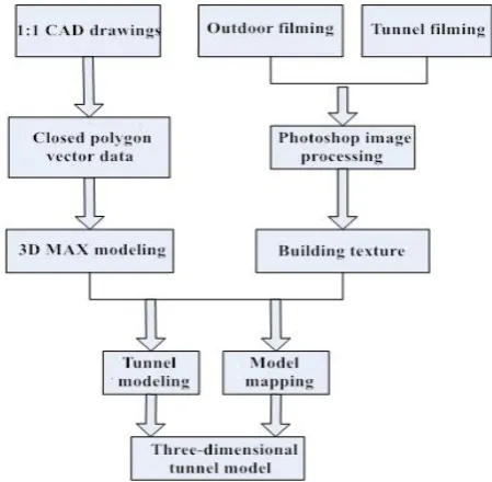
[image:3.595.184.409.213.433.2]The essence of establishing three dimensional model of rock mass tunnel, it is the visualization expression of the information of the original geological data of the region in which the tunnel is located, the geological structure of the stratum and the information of the space position and structure size of the relevant tunnel in the computer. According to the characteristics of tunnel modeling, 3D terrain, typical geological structure, tunnel internal structure modeling and related equipment modeling are considered in modeling.
Figure 1. Tunnel modeling process.
Modeling Data Acquisition
Data acquisition is the foundation of tunnel modeling. The accuracy of data directly determines the level of the degree of simulation. Good data acquisition can lay a solid foundation for accurate modeling. The data collection content is as follows:
Three Dimensional Spatial Data Acquisition. The key point coordinates of modeling object in space can accurately locate the position of each object. The key data of the tunnel, such as tunnel section, length and direction, can basically determine the 3D spatial information of the tunnel. The establishment of 3D tunnel model is mainly based on the existing tunnel planning data as the main source of spatial data, including roadway section diagrams, excavation engineering plans and other CAD drawings, as shown in Fig.2.
Figure 2. Tunnel section CAD diagram.
[image:3.595.175.421.622.745.2]Data Acquisition Method of Ground Surface and Stratum. The ground surface data includes the area where the tunnel is located, 1:10000 terrain, satellite image of meter resolution, ground surface construction, road and other data. Stratum data includes relevant geological lithology, important faults and other data. The above data can be collected through surveying and mapping achievements and field collection.
Tunnel Scene Terrain Modeling
By adding the real terrain condition and environment into the tunnel modeling, the environmental structure of the rock mass tunnel can be clearly demonstrated, which can realize the combination of the environmental display and the construction information of the three-dimensional mountain tunnel, which is helpful for people to understand. More information will be provided for construction management and decision-making. Therefore, topographic and geological modeling of rock mass tunnel is an important aspect.
[image:4.595.185.414.415.585.2]The data sources of 3D ground surface model are different according to the actual situation of engineering, but the most important data come from the contour map of Auto CAD. In general engineering, in the design stage, the basic measurement data are provided. These data include contour maps, through which ground surface models can be generated [5]. The contour information is read from the DXF file and dispersed into a series of irregular point sets. For the irregular distribution of elevation points, it can be formally described as an unordered point set P in the plane, and each point in the point set corresponds to their elevation points. When the elevation points are densely distributed, spatial interpolation can be directly converted to a TIN grid without spatial interpolation. Texture mapping can be realized by reading ground surface image data. The texture coordinates of ground surface nodes are usually determined by the UVW mapping function of 3D MAX [6]. An example of a 3D ground surface model based on elevation information is shown in Fig. 3:
Figure 3. Tunnel 3D ground surface model.
In 3D MAX, stratum layers and boundary faces are added to form three-dimensional entities. In fact, a Boolean clipping operation is performed on the already established regional terrain contour body and the upper and lower interfaces of the stratum, so that the stratum solid model reflecting the tunnel area can be more conveniently obtained.
Tunnel Model Modeling Method
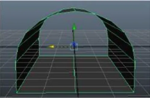
Tunnel section is an important parameter in geometric modeling, which mainly includes arch, circle, rectangle, trapezoid and etc. Taking the arched section as an example, to simulate the tunnel section, it is necessary to obtain the geometric control points of the section from the design data. The lateral wall of the tunnel is determined by the upper and lower endpoints of the side wall, and the height of the tunnel is obtained by the control point of the top arch. When the cross-section data of the tunnel are obtained, the control points of the first and the tail tunnel sections can be obtained according to the data of the starting node and the terminal node respectively. In the process of obtaining control points mentioned above, in order to be convenient for calculation, local coordinate system is usually set in 3D MAX, so it is necessary to transform all control points' coordinates into coordinates in the same coordinate system. After obtaining the coordinates, the section of the tunnel can be constructed, the center line is the axis of the bottom plate of the tunnel, and the three-dimensional model of the tunnel body can be established by using the lofting along the axis. Finally, the tunnel is operated by entity set, the redundant curve or curved surface is eliminated, and the repeated parts are combined to obtain the complete 3D geometric model of rock mass tunnel.
Figure 4. Linear tunnel modeling.
Figure 5. Tunnel connection modeling.
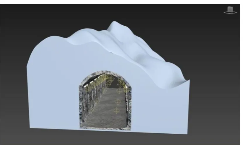
The Tunnel Intersects the Mountain. The intersection of tunnel and mountain is to unify the tunnel model with the three-dimensional terrain model and to provide the terrain information and geological analysis which are closely related to the project in order to truly serve the construction of the project.
Taking the 3D terrain model as the object, the tunnel model is used to perform a series of Boolean difference operations between the body and the body, and thus the rock mass tunnel model is obtained. The model can reflect both terrain information and the construction of tunnel buildings under corresponding conditions simultaneously [7]. The specific steps are as follows: according to the design parameters of the tunnel, the three-dimensional solid shape of the tunnel is generated; the generated tunnel and the stratum are subtracted, and the stratum part is partially layered, and the tunnel and stratum information are intersected to make the tunnel reflect the stratum information.
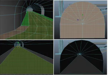
[image:6.595.92.510.466.715.2]Tunnel Modeling Post-optimization
The sense of reality of the 3D model depends largely on visual perception. In order to make the model more realistic, vivid and true, according to the characteristics of the project, it is necessary to use some methods and techniques to improve the visual effect.
The Arrangement of Scene Tone
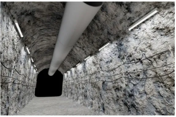
Tunnel scene is huge, need to have a higher grasp of the overall tone and atmosphere of the tunnel. In order to maintain a consistent bright tone, the color of the model, lighting effects and so on must be coordinated, as much as possible collection, collation of possible use of various materials, including construction pictures, actual photos, videos, models, texture mappings and so on. The atmosphere of the scene should coincide with the construction environment, and all kinds of construction scenes need to be reconstructed in the computer according to the real environment.
[image:7.595.155.442.333.524.2]The background of tunnel construction will directly affect the visual effect of the whole scene. The performance of the tunnel scene requires the selection of appropriate lighting, and the color, intensity, shadow, and illumination distance of the lighting are reasonably set to simulate the color and atmosphere of the construction scene, such as the dim light in the tunnel and the smoke and dust effect in the tunneling. It can be created by using the "Particles Illusion" plug-in, which creates real smoke, dust and other scenes. The final result is shown in Fig. 7:
Figure 7. Tunnel Model built by 3D MAX.
Mapping and Surface Number Processing
Figure 8. Tunnel model surface number optimization.
Summary
3D MAX provides powerful modeling tools such as standard basic body, extended basic body, composite object, basic geometric figure, editable spline line, editable polygon, facet modeling, editable mesh, NURBS modeling, polygonal based modeling tools and dynamic modeling, etc., through the comprehensive use of these modeling tools and with many modified tools of 3D MAX, we can make most of the models in the construction process. This paper builds a tunnel model based on 3D MAX. It introduces in detail the preparation work of model construction, how to build the model and post-processing work. The same steps can be applied to other modeling work on 3D MAX, such as campus modeling, indoor modeling, community modeling, etc., achieve the modeling of various other buildings.
References
[1]Lou Q. Y, Cheng X. J. Building Three-dimensional Modeling Based on AutoCAD and 3DMax. Journal of Engineering Investigation, 01(2013).
[2]Song H. W, Sinking and driving engineering, Coal Industry Publishing House, Beijing, 2006.
[3]Zhao X.W, Jin F.X. Urban 3D Modeling Method and Application Research, Journal of Geomatics, Wuhan, 34(4):11-12(2009).
[4]Shi Y. T, Chen X. J, Zhang H. F. Modeling Accuracy of Terrestrial Three-Dimensional Laser Scanning, Henan Sciences, Zhengzhou, 2(28):182-186(2010).
[5]Zhang H. F, Chen X. J, Wang F. Application of Laser Scanning Technology in Building Digitization, Geospatial Information, Wuhan, 9(3):86-89(2011).
[6]Zhou Y, Li H, Wang T. F. Opencast mine close range image beam method of 3D modeling and dynamic monitoring system, Engineering of Surveying and Mapping, Harbin, 25(2):61-65(2016).
[7]Liu X. Y, Lin H, Zhang H. The Principle and Method of Virtual City Construction, Science Press, Beijing, 2003.