The role of privately owned sports related
green spaces in urban ecological
frameworks
James, P and Gardner, E
Title
The role of privately owned sports related green spaces in urban ecological
frameworks
Authors
James, P and Gardner, E
Type
Book Section
URL
This version is available at: http://usir.salford.ac.uk/9544/
Published Date
2009
USIR is a digital collection of the research output of the University of Salford. Where copyright
permits, full text material held in the repository is made freely available online and can be read,
downloaded and copied for noncommercial private study or research purposes. Please check the
manuscript for any further copyright restrictions.
A
n ecological framework seeks to maintain ecological processes in the wider landscape and to conserve ecosystems, habitats, species, genetic diversity, and landscapes of importance. As greater attention is paid to ecological frameworks and in particular to such frameworks within an urban setting, then an understanding of the landscape ecology of sports related open spaces and their position within the wider ecological setting of a city requires attention. In this chapter we focus on golf courses and in particular address questions relating to their historic development and their con-temporary role in urban ecosystems. The exploration of these issues will be based on a case study centred on a new golf course development constructed in the 1990s at the Marriott Worsley Park, Salford UK. In this case study the historic development of Salford is outlined and the development of the Marriott Worsley Park is discussed in detail. Contemporary land use data are presented in order to understand the spatial importance of sports and open space within the city. This analysis leads to suggestions for the inclusion of sports space, and in particular golf courses within urban ecological frameworks.Land use changes in Salford
Salford is a historic settlement, noted in the Anglo-Saxon Chronicle and the Doomsday Book.1 The name Salford originates from sal, the Latin Salix
meaning sallow or willow, and ‘ford’, the only place to cross the River Irwell for many miles in either direction. It was the willow tree-lined banks of the Irwell that separated Salford from the, now better known, city of Manchester. Salford developed in the later eighteenth and nineteenth centuries from a village on the banks of the Irwell, to become an industrial city. Its industry was based on cloth, silk weaving, dyeing and bleaching.2
The proximity of the Manchester Ship Canal, and Salford’s own docks,
PHILIP JAMES AND EMMA L. GARDNER
10 The Role of Privately Owned Sports
Related Green Spaces in Urban
Ecological Frameworks
1 P. Teague, The Salford Eye – A Background, Salford Eye. 2000 Available internet: http:// www.geocities.com/Paulontheair/salf3.html. Accessed on: 19 March 2002.
meant that the city was at the hub of the transport infrastructure, procuring raw materials and distributing manufactured goods from the Northwest.
Poverty and industrial squalor were dominant features of life in the Victorian city. Houses built for the growing population of industrial and manufacturing workers were of a poor standard; these cramped houses, as many as 200 per hectare, with poor sanitation, were crowded into ‘slums’. During the late 1950s the slums were destroyed. People were moved to new housing estates, built throughout suburban and rural Salford. For example, it was at this time that the village of Little Hulton, ‘Little Hill Town’, was transformed from an idyllic village into a mosaic of council housing estates. Four large house-building phases occurred throughout the 1950s and 1960s, converting agricultural land into houses, shops, schools and roads. The area’s natural environment and community characteristics were lost to over-development, social decay and degradation. In this way the scars from Salford’s industrial past were extended both in time and space.
At the start of the twenty-first century Salford is a dynamic city, which has undergone radical transformations since becoming one of the world’s first industrial cities.3Through extensive development and regeneration the
city has been transformed from industrial decline and obscurity into a cultural and modern city. For example, Salford docks closed in the 1970s and the surrounding area spiralled into disuse and neglect accompanied by associated economic and social issues. During 1987, the Trafford Development Corporation was set up to encourage and attract new businesses into the region. This led to the transformation of Salford docks into Salford Quays, a hub of service industries, luxury water-front homes, and cultural and entertainment facilities.
Since the late 1980s the city has been constantly renewing itself and tackling the social, economic and physical implications of industrial decline.4
The city of Salford has set out to reverse decay and degradation through a range of initiatives establishing itself with an international reputation for successful regeneration.5 Today, largely as a result of regeneration activities,
Salford is a city of contrasts: thriving business districts of Central Salford and Salford Quays, extensive inner city areas of Ordsall, Weaste, Eccles, Pendleton, Broughton and Blackfriars, and the picturesque village of Worsley. These built environments give way to large tracts of open countryside, much of which is prime agricultural land created from the former peat rich areas (known locally as mosslands) of Chat Moss, Linnyshaw Moss and Clifton Moss. Much of this agricultural land (approximately one third of the total area of Salford) is designated as Green Belt. The fundamental aim of Green Belt policy is to prevent urban sprawl by keeping land permanently open.6
3 City of Salford, Salford Partnership. 1998. Building Sustainable Communities. A Re-generation Strategy for Salford, Salford: City of Salford 1998.
4 City of Salford, Milestones: The Story of Salford Quays, Salford: Salford City Council 2005.
The Role of Privately Owned Sports Related Green Spaces
Land use data compiled by the UK Government show that 55.7 per cent of the land in Salford is classified as green space. A very wide range of land uses are included in ‘green space’, including all agricultural land uses and all types of open space. Domestic gardens comprise a further 14.6 per cent of the land area of the city giving a total of 70.3 per cent of open space within the city (Table 10.1).7
Table 10.1 Land use in Salford
Land Use Categories, Area for each category Percentage
simplified in 2005 (ha)
Domestic Buildings 524 5.4
Gardens 1421 14.6
Non-Domestic Buildings 360 3.7
Road 1007 10.4
Rail 68 0.7
Path 74 0.8
Green space 5400 55.7
Water 177 1.8
Other 669 6.9
Not classified 0 0.0
TOTAL 9700 100.0
Source:Communities and Local Government Land Use Statistics for Salford January 2005, updated 27th Jamuary 2007
At a more detailed level, data from the city of Salford provides an audit of green space at both a city and community committee area.8 Importantly,
within the context of this paper, golf courses comprise 8.0 per cent and sports pitches a further 8.1 per cent of the open space of the whole city. Overall, about 64 per cent of the city can be considered as urban. Sports fields and golf courses comprise 22 per cent of the open space, space which could make a vital contribution to protecting and enhancing biodiversity within the city.
Broadening the discussion to the wider region around Salford – Greater Manchester – we see similar problems, opportunities and challenges. As in Salford, there has been a major decline in manufacturing industry, which has led to the development of service industries. These service industries are often located outside urban centres, in suburban locations. Changing economic activity from the declining manufacturing industries and the expanding service sector, has decentralised employment and population,
7 Communities and Local Government, Land Use Statistics for Salford January 2005.
Available internet: http://www.neighbourhood.statistics.gov.uk/dissemination/ LeadTableView.do?a=3&b=276781&c=salford&d=13&e=8&g=354179&i=1001x1003x 1004&m= 0&r=1&s=1254210295367&enc=1&dsFamilyId=1201 Accessed 28th September 2009.
which have brought housing, transport and development problems. The
Association of Greater Manchester Authorities, a body which represents the ten Greater Manchester city and metropolitan councils, highlights the promotion of development and regeneration throughout Greater Manchester as a main priority for the region, with the aim to strengthen economies and improve physical and social infrastructure. The major economic growth and developments have been in suburban and periurban areas ‘…where open land has been easier, cheaper and more attractive to develop.’9 Greater
Manchester’s countryside, habitats, wildlife, green space and brown-field sites are at risk from encroachment by industry, housing and business park developments and landfill sites. Woodland planting schemes and recreational usage also threaten Greater Manchester’s habitats and wildlife.10 Here, as in
Salford, the growth of golf courses in recent years raises questions over the impacts of open space used for sporting activities within the context of the landscape ecology of the urban area and more widely within the context of the sustainability of an area.
The growth of the golf industry
The number of golf course developments has dramatically increased since the mid 1980s (Figure 10.1).11 As the number of golf course developments
increase and, as more people turn to golf in their leisure time, the environment, economy and community role that golf courses play becomes significant. A report by the Golf Research Group based on a telephone survey of every golf course in the UK declared that there were 2,407 golf courses in the UK; 890 of these were classed as exclusive.12
The data in Figure 10.1. illustrates the number of courses, which have been built on greenfield sites. This number peaked in 1993. Since then, the number of new developments has declined. The average course had 529 members totalling approximately 1.17 million golf members in the United Kingdom in 2001, with a further 7.5 million people who really want to play golf. Although more people are interested in playing golf, unfortunately, many people in the UK are put off by the perception that golf is expensive (equipment and lessons), difficult to learn, takes too long to play, and is socially exclusive.13
To encourage more people to play golf throughout the UK, golf, following the United States model, is becoming relatively less expensive and more
9 AGMA, Association of Greater Manchester Authorities, Review of Greater Manchester Strategic Planning Framework 1999. Available internet: www.stockport.gov.uk/council/ eed/planning/gmspf.pdf. Accessed on 14 September 2002.
10Countryside Agency Manchester Conurbation. Available internet: http://www.countryside. gov.uk/LivingLandscapes/countryside_character/north_west/manchester_conurbation.asp. Accessed on 22 November, 2003.
11 D. Gilleece, Growth Continues to Carry On, 1998. Available internet: www.golf-research.com/irishpress.htm. Accessed on 7 August 2002.
12 Golf Research Group. Financial Performance of UK Golf Courses, Golf Research. 2001.
The Role of Privately Owned Sports Related Green Spaces
Figure 10.1 Number of new UK golf course developments built in 1985–1998 Source: Golf Research Group
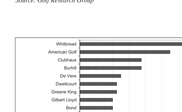
Figure 10.2 Percentage of new golf course developments, by multinational organisations, in the UK during the 1990s
Source: Golf Research Group. Financial Performance of UK Golf Courses, 2001.
0 2 4 6 8 10 12 14 16 18
CCA Asia CCA America Vivian Saunders Sunley Group PGA European Tour Courses Bond Gilbert Lloyd Greene King Dwellcourt De Vere Burhill Clubhaus American Golf Whitbread
% new golf courses development in the UK 0
10 20 30 40 50 60 70 80 90 100
85 86 87 88 89 90 91 92 93 94 95 96 97 98
Year
Number
Including expansions
[image:6.595.133.451.324.521.2]egalitarian. In the 1990s there was an emergence of golf chains (see Figure 10.2). Golf companies owning multiple courses in the UK include Whitbread, American Golf Corp and Clubhaus. Golf course chains can offer a more affordable, accessible way into the game because of their deep pockets and economies of scale. It appears that commercial rather than social interests have driven these developments. Many of these courses, by incorporating health and fitness club facilities alongside the golf courses, are built to attract whole families, rather than just men. This style of development, which provides extra facilities for families, appears to be working. At the same time, the golf industry is subject to fluctuation in numbers and, hence, economic performance. There has been a strong increase in the number of developments since 1985 and, during the 1990s, a large proportion of these were completed by multinational organisations.
As golf courses occupy a significant area of cities they have the potential to be the lungs of urban, periurban, suburban living. If this is so, an increase in the number of golf courses would be beneficial to both the natural environment and the local community. To ensure environmental and community benefits, an environmental management programme for the golf course should be a priority. However, if the golf industry, like the tourism industry, is susceptible to economic fluctuations, during economic downturns the amount of money spent playing golf would be affected. This has implications for environmental management and environmental management plans, both of which involve money and a great deal of time, and under difficult circumstances implementation may discontinue. In other words, if golf courses are the lungs of urban living and their economic viability declines, then golf courses could experience the same fate as agricultural lands. At this point it may be useful to look at the development of one particular gold course, the Marriot Worsely Park, and examine the landscape ecology implications of its development.
Case-study: The Marriott Worsley Park
The Marriott Worsley Park (MWP) is a classic case of the reallocation of periurban agricultural land from agriculture to sport and recreational use. Worsley is recognised as one of the cradles of the Industrial Revolution. The presence of coal was recorded as early as the 1300s.14 In 1759 an
application was made to Parliament to construct a canal from Worsley to Manchester in order to transport cheap coal to the evolving powerhouse of Manchester.15 This canal, the Bridgewater, became the first large-scale
commercially viable canal in Britain. Coal mining ceased in 1887.16
14 N. Redman, An Illustrated History of Worsley and the Marriott Manchester Hotel and Country Club, Whitbread PLC 1998.
15 H. Wickham, Worsley in the 18th century. A Study of a Lancashire Landscape, Neil Richardson 1984.
The Role of Privately Owned Sports Related Green Spaces
During the 1960s farmland around Worsely was turned into housing developments. Peel Holdings plc, who purchased Bridgewater Estates in 1984,initiated further housing programmes on farmland surrounding the village during the 1980s and 1990s. In 1987 Peel Holdings plc commissioned L&R Leisure Consultants to report on existing facilities in the area and to identify the most viable option for future development. Their final report proposed a hotel and leisure complex. This encouraged Peel Holdings plc to apply for planning permission. Plans were presented which incorporated the extant Worsley Old Hall, redevelopment of Old Hall Farm, and the construction of a golf course. In April 1990 the new plans were passed by Salford City Council.17 The proposed regeneration of Worsley Old Hall and
Old Hall Farm, which had been neglected since the tenants left in 1988 and had fallen into disrepair, encouraged residents to back Peel Holdings’ plans. Finally, in 1995 Whitbread plc took over the site announcing a £15 million development and used their own landscape and architecture consultants to develop the site plans. Work began on the site in 1997; the hotel opened in 1998 and the golf course opened in spring 1999.
The MWP site can be conveniently separated into hotel and leisure centre buildings, the grounds surrounding the hotel and leisure centre, and the golf course. The grounds surrounding the hotel and leisure centre are largely manicured, ornamental landscaped gardens designed to minimise the impact of the hotel buildings and car parks on the landscape, and offer ornamental and seasonal interest.18 The golf course and surrounding grounds are less
ornamental, designed to provide a challenge and aesthetic interest for the golfers.
Initial development of the golf course involved heavy construction and intense land movement. Topsoil was removed (a condition of the planning application was that no soil was allowed to leave the site), sub-soil was shaped and the topsoil replaced to a depth of approximately 100–150mm to create an undulating landscape which is evident today. An irrigation system was designed to collect rainwater which would be stored in a reservoir for use in the summer months. Soil dug out to create the lakes and reservoir was also used to create the undulating features of the golf course. In addition to the soil dug out on site, materials were brought from outside the MWP site to aid golf course design and create the current golf conditions. These materials were sand, gravel, root zone (a combination of sand and peat) and pre-germinated seeds (mixed with water and paper). Such materials affect plant growth by facilitating good turf growth and increasing the kind of turf condition which golfers aspire to play on.
Plantations were incorporated into the golf course design to integrate the course with the existing woodland, compensate for any loss of hedgerow and woodland, delineate fairways and provide a challenging golf course. Approximately 46,000 whips of mixed species were planted. Since planting, the plantations have been thinned as appropriate.
17 P. Nears, Personal communication, Strategic Planning Officer, Peel Holdongs plc, Peel Dome, The Trafford Centre, 23 October, 2002.
In addition to scattered mature Beech (Fagus sylvatica), Sycamore (Acer pseudoplatanus), Common Lime (Tilia x europaea), Oak (Quercus robur) and Holly (Ilex aquifolium) which were found across the golf course, the MWP site contained six blocks of woodland. The oldest woodland, Rands Clough, appears on a map dated 1764. Rhododendron (Rhododendron ponticum) was spread throughout the majority of the golf course and was found in all but two of the woods. During the construction of MWP areas of woodland were destroyed, but fifteen additional plantations (of approximately 30 whips and trees) were planted to compensate for any loss.
Hedgerows, an important wildlife habitat, were found across the site. Prior to construction, hedgerows had not been managed since the last farming tenants left in 1988 and all were overgrown, with poor ground flora, and gaps throughout. Extant hedgerows were dominated by Hawthorn (Crataegus monogyna). There was no evidence of ancient hedgerows at the MWP site.19
During golf course construction, one hedgerow was completely removed and five hedgerows were fragmented by footpaths, golf buggy paths and fairways.
To the south of the golf course a stream was constructed to increase the challenge of the golf course and for aesthetic purposes. Three remnant ponds were incorporated into the course design. These appeared eutrophic and overgrown with Greater Reedmace (Typha latifolia). During the growing season of 2001 a 10-meter buffer zone was established around the ponds to prevent further nutrient enrichment. Ponds are regionally important habitats.20
All three ponds were reported to contain fish, Common Frog (Rana temporaria) and Common Toad (Bufo bufo). Smooth Newt (Lissotriton vulgaris) and Palmate Newt (L.helveticus) have been sighted on the golf course. In addition, there are four wetlands, three permanent and one seasonal, on the MWP site. Common species in these wet areas include Greater Reedmace (Typha latifolia), Yellow Flag Iris (Iris pseudocorus), Common Duckweed (Lemna minor) and Water Thyme (Elodea sp.).
Since construction, and subsequent play and management, the MWP greenkeepers have incorporated an environmental management regime which encourages sward growth and reduces chemical applications throughout areas of rough, limits the amount of alien species such as Rhododendron (Rhododendron ponticum), encourages buffer zones around waterbodies and supports natural regeneration within woodland and the woodland edge.
The MWP is bordered by residential housing to the east, south and west, and a transport corridor to the north. Walkden Road, to the east, is pre-dominantly detached housing with large gardens and large mature trees; additionally there are a number of terraced and semi-detached houses with smaller mature gardens. To the south, Leigh Road, has a mixture of larger and smaller detached properties all with mature gardens. Similarly to the west Randsclough and Stechworth Streets contain semi-detached housing
19 P. Tattersfield, Worsley Park: An Appraisal of its Nature Conservation Value and Implications for Development, Manchester: Penny Anderson Associates 1990.
The Role of Privately Owned Sports Related Green Spaces
with mature gardens. The importance of urban gardens has been long recognised. However, due to access difficulties they remained an understudied aspect of our natural heritage. A project lead by the University of Sheffield – Biodiversity in Urban Gardens – has gone a long way to address this issue. An important finding from that project is that domestic gardens can form extensive, inter-connected tracts of green space. Therefore, as for other categories of urban green space, the benefits of individual gardens probably arise from their role as isolated patches, as components of a landscape that includes other vegetation or as corridors through the urban matrix. The most important factor determining the biodiversity value of a garden is the structure of the vegetation.21 Hence as many of the gardens surrounding the MWP
are described as mature (with the majority classed as medium-large gardens) it could be assumed that these gardens may be biodiversity rich and/or offer value as corridors and feeding grounds to species or habitats associated with the MWP and with the wider Salford community area as a whole.
Findings from the case-study
The analysis of land use within the city of Salford presented in this chapter clearly illustrates the importance of sports pitches and golf course in terms of the area of the city devoted to these uses. Open space strategies for the city demonstrate that they concentrate on the public open space and seem to overlook the large areas which are in private ownership. This is an important omission because whilst planners are not able to dictate practices in existing developments they are able to make recommendations in the context of new developments which could significantly affect the resultant structure and functionality of a development.
Analysis of the habitats created and the species of plants incorporated into the design of MWP indicates that many of the features of the wider landscape are incorporated into the golf course. It is important to recognise that within a golf course much of the area is not used for golf: as little as 10 per cent of the area needs to be intensively managed leaving 90 per cent available as wildlife habitat.22 Hence, although difficult to quantify precisely,
it is clear that the nature resource of a city is much larger than those publicly owned sites which are addressed in green space strategies and extends into land in private ownership of which gardens and golf courses are important components.
This leads to a new model for the creation of urban ecological frameworks. The model emphasises that nature conservation gains are achieved by recommending general measures (using the most up-to-date studies of best practice available) that can be used to enhance biodiversity wherever and whenever possible. Species populations will benefit from this approach but
21 R.M. Smith, K.J. Gaston, P.H. Warren and K. Thompson, ‘Urban Domestic Gardens (V): Relationships Between Landcover Composition, Housing and Landscape’, Landscape Ecology 20 (2005), 235–253.
in a much less structured and guided way than by formally designating or creating a framework comprising core areas, nature restoration zones, buffer zones and corridors. By adopting the policy proposed here, recognising a great diversity of public and private green spaces, a sustainable framework emerges from the ‘ground up’ rather than from the ‘top down’.
One outcome of this model is a ‘toolkit’ recommending the best ways of improving urban areas for biodiversity in general terms, together with some spatial information about where the tools in the kit should be put to best use. In a sense this framework model also seeks to establish an informed ‘frame of mind’, encouraging measures to be taken to enhance biodiversity wherever possible.