North Carolina Geospatial Data Archiving Project
Frequency of Geospatial Data Capture
Survey conducted by
NC Center for Geographic Information & Analysis
Under a Partnership with
The Library of Congress
National Digital Information Infrastructure and Preservation Program (NDIIPP)
and
North Carolina State University Libraries
November 15, 2006
North Carolina Geospatial Data Archiving Project
Frequency of Geospatial Data Capture
Survey of Local Government GIS Contacts
Project Introduction
As described on www.digitalpreservation.gov: The joint project of the North Carolina State
University Libraries and the North Carolina Center for Geographic Information and Analysis in
partnership with The Library of Congress, National Digital Information Infrastructure and
Preservation Program will focus on collection and preservation of digital geospatial data
resources from state and local government agencies in North Carolina.
The objectives of the project include:
•
Identification of available resources through the NC OneMap data inventory
•
Acquisition of at risk geospatial data, including static data such as digital orthophotos as
well time series data such as local land records and assessment data
•
Development of a digital repository architecture for geospatial data, using open source
software tools such as DSpace
•
Enhancement of existing geospatial metadata with additional preservation metadata,
using Metadata Encoding and Transmission Standard (METS) records as wrappers
•
Investigation of automated identification and capture of data resources using emerging
OpenGeospatial Consortium specifications for client interaction with data on remote
servers
•
Development of a model for data archiving and time series development
Survey Overview
The North Carolina Geospatial Data Archiving Project (NCGDAP) is in the process of obtaining
archival snapshots of county and city geospatial vector data layers and is seeking guidance
about frequency of capture. At the same time, there is interest in defining a set of best practices
with regard to maintenance of data archives at the local agency level, including periodic capture
of vector data and associated attributes. In addition, State Archives has expressed preliminary
interest in establishing a connection between records retention scheduling processes and any
elaborated best practices for data archiving. NCSU, CGIA, and State Archives collaborated to
develop a survey instrument to assess current data archiving practice at the county and
municipal level. The survey was administered between September 13 and September 28, 2006
using the SurveyMonkey.com web service.
Survey Objective
The objective of the survey was to document current practices among county and municipal GIS
practitioners relating to the frequency of capture of geospatial data for purposes of long-term
retention. The survey distinguished between regular data back-up for disaster recovery
purposes and retention of geospatial records for archiving purposes.
Response Status
The survey was sent to a list of local government GIS contacts covering all 100 counties and 25
of the largest municipalities. In North Carolina, local geospatial framework datasets are
produced and managed by counties for the most part. Land records (cadastral data) are
managed by counties as well as street centerlines and orthophotos. Municipalities typically
have a role in managing geospatial representations of jurisdictional boundaries as well as
planning and permit-related datasets.
A total of 72 respondents represented 61 of 100 counties and 11 municipalities. This was a
strong response to an online survey. The county respondents included a range of sizes
(population) and GIS capabilities. The counties that responded had somewhat larger resident
populations than the counties that did not respond as shown in Table 1.
Table 1: Population of Jurisdiction by Response Status
Status of County Population mean median Responded (N = 61) 5,669,527 92,943 48,498 No response (N = 39) 2,379,786 61,020 36,348
Results
Two-thirds of the respondents indicated that they create and retain periodic snapshots of any
vector datasets for long-term retention and archiving. The responding counties that do not
capture any vector data for long-term retention tend to be smaller in terms of population as
shown in Table 2. Lists of jurisdictions that capture and do not capture data are shown in
Tables 3 and 4.
Table 2: Population of Jurisdiction by Status of Data Capture Practices
Status of County Population mean median Capture data (N = 43) 4,810,592 111,874 59,648 Do not capture data (N = 18) 858,935 47,719 29,967
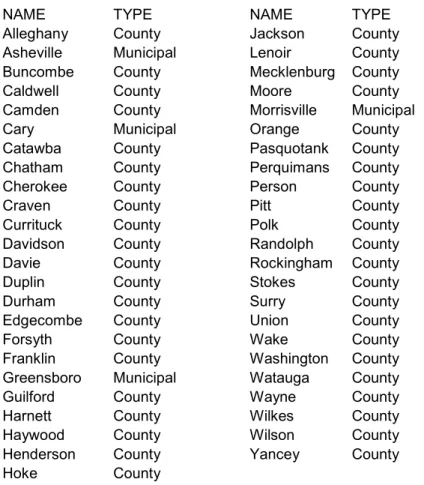
Table 3: Jurisdictions That Capture Vector Data for Long-Term Retention
NAME TYPE NAME TYPE
Alleghany County Jackson County Asheville Municipal Lenoir County Buncombe County Mecklenburg County Caldwell County Moore County Camden County Morrisville Municipal Cary Municipal Orange County Catawba County Pasquotank County Chatham County Perquimans County Cherokee County Person County
Craven County Pitt County
Currituck County Polk County Davidson County Randolph County Davie County Rockingham County
Duplin County Stokes County
Durham County Surry County
Edgecombe County Union County
Forsyth County Wake County
Franklin County Washington County Greensboro Municipal Watauga County Guilford County Wayne County Harnett County Wilkes County Haywood County Wilson County Henderson County Yancey County Hoke County
Table 4: Jurisdictions That Do Not Capture Vector Data for Retention
NAME TYPE NAME TYPE
Alexander County Laurinburg Municipal
Ashe County Macon County
Beaufort County Martin County Boone Municipal Mitchell County
Burke County Nash County
Burlington Municipal New Bern Municipal Carrboro Municipal Onslow County Caswell County Richmond County Charlotte Municipal Robeson County Dare County Salisbury Municipal Graham County Transylvania County Granville County Vance County Hyde County
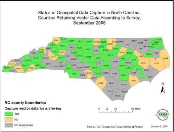
A map of the status of data capture by county is shown in Figure 1. The patterns of archiving
and survey participation are a bit different than the current participation (data serving) in the NC
OneMap map viewer (Figure 2).
Figure 1: Data Capture Status by County
In brief, about two-thirds of local government GIS coordinators are taking time to capture
geospatial datasets, at least on an annual basis. For those who capture data more often than
annually, the frequency varies from weekly to semi-annually. Cadastral data are most
commonly archived among the respondents (41 of the 47 who retain geospatial data). Archiving
occurs to a somewhat lesser extent for street centerlines (28 of the respondents), jurisdictional
boundaries (28), and zoning (26). As a share of all survey respondents, geospatial records are
archived for cadastral (57 percent), street centerlines (39 percent), jurisdictional boundaries (39
percent), and zoning (36 percent).
There are several business rules and needs that drive retention, including historic mapping, tax
administration rules, information technology policies, records for resolution of legal issues,
records retention policies, and land use change analysis.
Storage formats tend to be consistent with the dominant GIS vendor among local governments
(ESRI). Storage environments vary, with servers and CDs the most common. Offsite storage
(or both onsite and offsite) is used by nearly half of the respondents.
In addition to vector data, 65 of the 72 respondents store digital orthophotos. The popularity of
historic images has resulted in scanning and geo-referencing of hardcopy aerial photos among
about one-third of the respondents.
Table 5. Summary of Survey Results
1 Do you create and retain periodic snapshots of any vector datasets for long-term retention and archiving?
Response Total Percent of Respondents Percent of Survey Takers Yes 47 65.3% 65.3% No 25 34.7% 34.7% Total Respondents 72 100.0% 100.0%
(skipped this question) 0 0.0% 0.0%
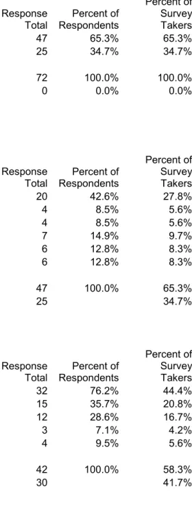
2 How often are snapshots of PARCEL geometry made for long-term retention? (choose frequency closest to your practice) Response Total Percent of Respondents Percent of Survey Takers Annually 20 42.6% 27.8% Every 6 Months 4 8.5% 5.6% Quarterly 4 8.5% 5.6% Monthly 7 14.9% 9.7% Weekly or Daily 6 12.8% 8.3% Not Saved 6 12.8% 8.3% Total Respondents 47 100.0% 65.3%
(skipped this question) 25 34.7%
3 In what formats are PARCEL geometry snapshots saved? (check all that apply)
Response Total Percent of Respondents Percent of Survey Takers Shapefile 32 76.2% 44.4% Geodatabase 15 35.7% 20.8% Arc Coverage 12 28.6% 16.7%
Arc Interchange (e00) 3 7.1% 4.2%
Other 4 9.5% 5.6%
Total Respondents 42 100.0% 58.3%
4 Does this involve a data conversion from the native format? (e.g. Geodatabase feature class export to shapefile) Response Total Percent of Respondents Percent of Survey Takers Yes 23 52.3% 31.9% No 21 47.7% 29.2% Total Respondents 44 100.0% 61.1%
(skipped this question) 28 38.9%
5 Are PARCEL attributes (such as tax record
information) saved with the PARCEL geometry data?
Response Total Percent of Respondents Percent of Survey Takers
Yes as attached attributes 27 61.4% 37.5%
Yes in a separate table 10 22.7% 13.9%
No 7 15.9% 9.7%
Total Respondents 44 100.0% 61.1%
(skipped this question) 28 38.9%
6 How often are snapshots of STREET CENTERLINE geometry made for long-term retention? (choose frequency that is closest to your practice)
Response Total Percent of Respondents Percent of Survey Takers Annually 13 28.3% 18.1% Every 6 Months 3 6.5% 4.2% Quarterly 4 8.7% 5.6% Monthly 5 10.9% 6.9% Weekly or Daily 3 6.5% 4.2% Not Saved 18 39.1% 25.0% Total Respondents 46 100.0% 63.9%
7 In what formats are STREET CENTERLINE geometry snapshots saved? (check all that apply)
Response Total Percent of Respondents Percent of Survey Takers Shapefile 24 77.4% 33.3% Geodatabase 8 25.8% 11.1% Arc Coverage 8 25.8% 11.1%
Arc Interchange (e00) 3 9.7% 4.2%
Other 3 9.7% 4.2%
Total Respondents 31 100.0% 43.1%
(skipped this question) 41 56.9%
8 Does this involve a data conversion from the native format? (e.g. MapInfo format to Shapefile)
Response Total Percent of Respondents Percent of Survey Takers Yes 12 34.3% 16.7% No 23 65.7% 31.9% Total Respondents 35 100.0% 48.6%
(skipped this question) 37 51.4%
9 Are STREET attributes saved with the STREET CENTERLINE geometry? Response Total Percent of Respondents Percent of Survey Takers
Yes as attached attributes 29 82.9% 40.3%
Yes in a separate table 2 5.7% 2.8%
No 4 11.4% 5.6%
Total Respondents 35 100.0% 48.6%
10 For which of the following JURISDICTIONAL BOUNDARY datasets do you create snapshots? (check all that apply)
Response Total Percent of Respondents Percent of Survey Takers County Boundaries 19 40.4% 26.4% Municipal Boundaries 25 53.2% 34.7% Extraterritorial Jurisdictions 16 34.0% 22.2% None 19 40.4% 26.4% Total Respondents 47 100.0% 65.3%
(skipped this question) 25 34.7%
11 How often are snapshots of JURISDICTIONAL BOUNDARY data made for long-term retention? (choose frequency closest to your practice)
Response Total Percent of Respondents Percent of Survey Takers Any time an official boundary change occurs 13 39.4% 18.1%
Annually 10 30.3% 13.9% Every 6 Months 3 9.1% 4.2% Quarterly 1 3.0% 1.4% Monthly 5 15.2% 6.9% Weekly or Daily 1 3.0% 1.4% Total Respondents 33 100.0% 45.8%
(skipped this question) 39 54.2%
12 In what formats are JURISDICTIONAL BOUNDARY data snapshots saved?
Response Total Percent of Respondents Percent of Survey Takers Shapefile 24 72.7% 33.3% Geodatabase 10 30.3% 13.9% Arc Coverage 7 21.2% 9.7%
Arc Interchange (e00) 2 6.1% 2.8%
Other 5 15.2% 6.9%
Total Respondents 33 100.0% 45.8%
13 Does this involve a data conversion from the native format? (e.g. Geodatabase feature class to shapefile)
Response Total Percent of Respondents Percent of Survey Takers Yes 11 34.4% 15.3% No 21 65.6% 29.2% Total Respondents 32 100.0% 44.4%
(skipped this question) 40 55.6%
14 How often are snapshots of ZONING geometry made for long-term retention? (choose frequency closest to your practice) Response Total Percent of Respondents Percent of Survey Takers Annually 16 34.8% 22.2% Every 6 Months 3 6.5% 4.2% Quarterly 2 4.3% 2.8% Monthly 4 8.7% 5.6% Weekly or Daily 1 2.2% 1.4% Not Saved 20 43.5% 27.8% Total Respondents 46 100.0% 63.9%
(skipped this question) 26 36.1%
15 In what formats are ZONING geometry snapshots saved? (check all that apply)
Response Total Percent of Respondents Percent of Survey Takers Shapefile 20 66.7% 27.8% Geodatabase 8 26.7% 11.1% Arc Coverage 6 20.0% 8.3%
Arc Interchange (e00) 2 6.7% 2.8%
Other 5 16.7% 6.9%
Total Respondents 30 100.0% 41.7%
16 Does this involve a conversion from the native format? (e.g. MapInfo to Shapefile)
Response Total Percent of Respondents Percent of Survey Takers Yes 11 35.5% 15.3% No 20 64.5% 27.8% Total Respondents 31 100.0% 43.1%
(skipped this question) 41 56.9%
17 Are ZONING attributes saved with ZONING geometry?
Response Total Percent of Respondents Percent of Survey Takers
Yes as attached attributes 25 78.1% 34.7%
Yes in a separate table 2 6.3% 2.8%
No 5 15.6% 6.9%
Total Respondents 32 100.0% 44.4%
(skipped this question) 40 55.6%
18 Please list or summarize any OTHER DATA layers you are archiving for long-term retention if any.
Total Respondents 24 100.0% 33.3%
(skipped this question) 48 66.7%
19 How far back does your archive of vector data snapshots go?
Total Respondents 39 100.0% 54.2%
(skipped this question) 33 45.8%
20 What METADATA types are saved with the snapshot data? Response Total Percent of Respondents Percent of Survey Takers FGDC format 12 25.5% 16.7%
Locally defined metadata 4 8.5% 5.6%
NC OneMap metadata starter block 3 6.4% 4.2%
None 28 59.6% 38.9%
Total Respondents 47 100.0% 65.3%
21 In what STORAGE environment are the snapshot data saved? Response Total Percent of Respondents Percent of Survey Takers Tape 10 21.3% 13.9% CD 20 42.6% 27.8% DVD 8 17.0% 11.1%
External Hard Drive 4 8.5% 5.6%
Server or Online Storage 27 57.4% 37.5%
Other 0 0.0% 0.0%
Total Respondents 47 100.0% 65.3%
(skipped this question) 25 34.7%
22 Where are the snapshot data stored?
Response Total Percent of Respondents Percent of Survey Takers Onsite 26 55.3% 36.1% Offsite 3 6.4% 4.2%
Both Onsite and Offsite 18 38.3% 25.0%
Total Respondents 47 100.0% 65.3%
(skipped this question) 25 34.7%
23 What local business RULES and/or USES drive the long-term retention of vector data in your
jurisdiction? (check all that apply)
Response Total Percent of Respondents Percent of Survey Takers
Information technology policy 9 19.6% 12.5%
Records retention policy 8 17.4% 11.1%
Tax administration rules 11 23.9% 15.3%
Land use change analysis 5 10.9% 6.9%
Resolution of legal issues 9 19.6% 12.5%
Historic mapping 26 56.5% 36.1%
Other 13 28.3% 18.1%
Total Respondents 46 100.0% 63.9%
24 Do you provide PUBLIC ACCESS to snapshots of vector data? Response Total Percent of Respondents Percent of Survey Takers
Yes all of the files 14 30.4% 19.4%
Yes some of the files 6 13.0% 8.3%
None 26 56.5% 36.1%
Total Respondents 46 100.0% 63.9%
(skipped this question) 26 36.1%
25 How are historic (superseded) digital ORTHOPHOTOS being stored? (check all that apply)
Response Total Percent of Respondents Percent of Survey Takers Tape 4 5.7% 5.6% CD 30 42.9% 41.7% DVD 23 32.9% 31.9%
External Hard Drive 13 18.6% 18.1%
Server or Online Storage 46 65.7% 63.9%
Other 10 14.3% 13.9%
Not Stored 5 7.1% 6.9%
Total Respondents 70 100.0% 97.2%
(skipped this question) 2 2.8%
26 Have you created digital versions of any of the following: Response Total Percent of Respondents Percent of Survey Takers
Historic hardcopy maps scanned only 11 15.5% 15.3%
Historic hardcopy maps scanned and geo-referenced 7 9.9% 9.7%
Aerial photos scanned only 6 8.5% 8.3%
Aerial photos scanned and geo-referenced 19 26.8% 26.4%
None 39 54.9%
Total Respondents 71 100.0% 98.6%
(skipped this question) 1 1.4%
27 Please add any additional comments clarifications or questions:
Total Respondents 15 100.0% 20.8%
28 Would you like to participate in FORUMS concerning preservation of local geospatial data?
Response Total Percent of Respondents Percent of Survey Takers Yes 26 38.2% 36.1% Not sure 26 38.2% 36.1% No 16 23.5% 22.2% Total Respondents 68 100.0% 94.4%
(skipped this question) 4 5.6%
Other data that are captured for long-term retention were described in responses to question 18.
18. Please list or summarize any OTHER DATA layers you are archiving for long-term retention, if any.
Comment:
Address points, driveway line segments, emergency service boundaries, school districts, contour line data, census boundaries, historic districts, railroad
centerline, township boundaries, subdivision boundaries, voting precincts, watershed overlay districts
I made an archive of my data when we converted from coverages to geodatabase. That is typically the only time I do an archived backup. I do a weekly backup of existing data but it is overwriting the previously saved data Fire districts, Fire stations, Building footprints, Boundary, CPL Areas, Easements, Lot lines, Utility easements, Child care, FEMA & regular flood, Government services, Pump stations, Schools, Senior citizen areas, Zoning, Airport boundary, County Offices, Tax Parcels, Roads
We had been periodically archiving impervious surface data for 'history' during the development process. At this time (now that the stormwater bills have gone out) we plan to track reductions/additions through HTE software and through our Appeals database (.mdb). For most other enterprise data we're relying upon ITS recovery mechanisms. I have also archived project/analysis level data using our CD Index.
Annexations, Zip codes, Pavement Management, Land use Fire Tax Districts
Land Use
All of our data is archived daily, then weekly, then monthly, and yearly. Flood Plain shapefiles ETJ shapefiles
Airport, bridges, churches, city limits, creeks, structures (houses), landmarks, land use, railway, soils, tar river, utility service areas, and cross road information.
Ortho Photos, Topographic maps, Planimetrics
All layers included on our Public Access CD (produced every 6 months). We keep one of each issue as an historic archive.
Ortho Photography, topographic maps, planimetrics, building footprints
Fire Districts Sanitary Districts Watersheds Federal Lands Land Cover Soils Topography Water lines Sewer lines Survey Monuments Voting Districts Flood Census
Imagery
Critical watershed areas Address points
We Archive All Property Ownership Records Along With Chain Of Title. We Have Scanned All 1993 Photo, 1974 Photo. We Also Have Scanned All
Recorded Survey Plats. All Sheriff, EMS, Fire, Zip, Township, Phone Messages, Zoning
Subdivisions Electoral Districts - precincts, congressional districts, NC House districts, Judicial districts, polling places
Address points Address points
Those not currently being archived are not yet in existence. We are only an emerging GIS. But it is my intention that ALL data will be archived.
Respondents were asked for comments about archiving in question 27.
27. Please add any additional comments, clarifications or questions: Response
1985 - blue hardcopy maps scanned and geo-referenced 1999 - Digital B&W saved on DVD and online 2002 - Digital color saved on DVD and online 2006 - new acquisition this year; The soil and water group here locally has some aerial imagery (B&W) hardcopy going back to the 1950s. I would like to have that scanned and
geo-referenced. Are there any funds (cost share) that would help with that effort? We'd like to be able to put them online for our users to view. Thanks!
We are looking into having old orthophotos scanned and geo-referenced. Getting ready to implement this type of archiving of data.
I have not done this, but it does seem like a good idea!
All of our data is kept monthly for 1 year; i.e., September 2006 tape will be overwritten September 2007.
Have old B/W photos (1990) that have been scanned to disk and original's are stored in Master File cabinet. Also new photo's stored on DVD.
We have taken our original 1990 aerial photography, scanned and geo-referenced the images. We will be adding other archive aerial imagery as available from NRCS. I do not see why this can not be incorporated with disaster recovery. Don't you think you would foster greater support?
We have sold CD copies of our annual data to the public for that current year, from 99 to the present.
We do not have any historic DIGITAL orthophotos. Our historic records are just hardcopy. The digital orthophotos that we are using are our only ones we have. We have hard copies of a historic Aerial Photo but no resources to scan
No emphasis on historical data here. We just try to keep from losing data completely. Very minimal hardware to work with and no money.
Our current digital orthophotography (flown spring of 2004) has not been superseded...yet.
Have not yet begun scanning old Aerials but intend to do so soon.
The survey questions are attached as Appendix A.
Conclusion
The survey results are encouraging for the NC Geospatial Data Archiving Project and provide
insights into frequency of capture and current practices. In addition, the survey brought
attention to the archiving issue for those GIS coordinators who are not capturing geospatial data
for long-term retention. This presents an opportunity for NCGDAP to influence the breadth and
quality of archived geospatial information in North Carolina.