Z
O
N
I
N
R E G U L A T I O N S
T
OwN
Of
H
AmdEN
, CT
T3.5This page intentionally
left blank
HAmdEN CONNECTICUT TOwN STAff:
mAyOR SCOTT JACkSON
fORmER mAyOR CRAIG HENRICI
LESLIE CREANE, AICP TOwN PLANNER
dAN kOPS, ASSISTANT TOwN PLANNER
STACy SHELLARd, AdmINISTRATIvE ASSISTANTTO BOARdS & COmmISSIONS
JOSEPH mCdONAGH, PLANNING & ZONING CHAIRPERSON
ANN ALTmAN, PLANNING SECTION CHAIRPERSON
Ed GRANT, ZONING SECTION CHAIRPERSON
LESLEy ANN dENARdIS, COmmISSIONER
GERALd dImENSTEIN, COmmISSIONER
dONALd mOSES, COmmISSIONER
PETER REyNOLdS, COmmISSIONER
RALPH RICCIO, COmmISSIONER
ROBERT ROSCOw, COmmISSIONER
LEONARd GRABOwSkI, ALTERNATE
RALPH mAROTTOLI, ALTERNATE
GREGORy TIGNOR, ALTERNATE
HAmdEN CONNECTICUT CUSTOmIZATION TEAm:
ROBERT ORR & ASSOCIATES
PLANImETRICS
RICHARd CHELmAN
fISHER TOwN dESIGN, INC.
ASSPECIALTHANkSTOTHECIvICANdNEIGHBORHOOdASSOCIATIOINSOf HAmdENANd THEHUNdRESOfINdIvIdUALSTHATPARTICIPATEdINTHEdEvELOPmENTOfTHISdOCUmENT.
NOTE: THEImAGESANddIAGRAmSAPPEARINGIN SmARTCOdE vERSION 9.0 ARETHEPROPERTyOf dUANy PLATER-Zy -BERk & COmPANy (dPZ). THEIRREPROdUCTIONANdUSEISfREELyPERmITTEdwITH “CREdIT: dUANy PLATER-ZyBERk
A
mENdmENTSTOTHEZ
ONINGR
EGULATIONST
OwNOfH
AmdEN, CT
(HAmdENfIRSTAdOPTEdZONINGREGULATIONSON dECEmBER 24, 1930)
AdOPTEd: dECEmBER 7, 2009 EffECTIvE: JANUARy 1, 2010 AmENdEd: mARCH 9, 2010 EffECTIvE: APRIL 15, 2010 AmENdEd: JULy 27, 2010 EffECTIvE: AUGUST 15, 2010
T
ABLE OfC
ONTENTSArticle i introduction
Section 100 Authority Section 110 Jurisdiction Section 120 Purpose
Section 130 Application of Regulations Section 140 Zoning Map and Districts
Section 150 Interpretation of Zoning Boundaries Section 160 Interpretation of Regulations
Section 170 Validity Section 180 Repealer Section 190 Effective Date
Article ii residentiAl Zones r1-r5
Section 200 Purpose
Section 210 Permitted Uses
Section 220 Area, Density and Dimensional Requirements
Article iii trAnsect Zones t1-t5 And speciAl districts
Section 300 Purpose
Section 310 Building Location Section 320 Building Massing Section 330 Special Requirements Section 340 Building Use
Section 350 Density and Parking Calculations
Section 360 Parking Location and Private Roadway Standards Section 370 Landscape Standards
Diagram
Building Location Private Frontages Civic Spaces
Form-Based Code Graphics T3 and T3.5
` Form-Based Code Graphics T4
Form-Based Code Graphics T5 Section 380 Special Districts
Manufacturing Newhall Center Town Green District
Article iV oVerlAy Zones
Section 400 Purpose
Section 410 Aquifer Protection Area (APA)
Section 420 Coastal Area Management Zone (CAM) Section 421 Purpose
6
Section 422 Location Section 423 Permitted Uses Section 424 Authority Section 425 Exceptions Section 426 Application Section 427 Impact Analysis Section 428 Public Hearing
Section 429 Commission Action and Referral
Section 430 Flood Plain Zones and Special Flood Hazard Areas Section 440 Open Space Development
Section 450 Village District Overlay Zones
Article V BAsic stAndArds
Section 500 Purpose
Section 510 General Requirements Section 520 Environmental Conditions
Section 530 Lot, Block and Building Configuration Section 540 Site Amenities
Section 550 Sign Regulations Section 560 Sidewalk Standards Section 570 Fences and Walls Section 580 Outdoor Lighting Section 590 Infrastructure
Section 591 Traffic, Parking and Loading Requirements
Article Vi speciAl proVisions
Section 600 Purpose
Section 610 Site Plan and Special Permit Uses
Section 620 Accessory Dwelling Units in Single-Family Homes Section 622 Adult Oriented Establishments
Section 624 Agriculture Section 626 Animals Section 628 Cemeteries
Section 630 Civic Clubs, Lodges or Associations (Non-Profit) Section 632 Community Residences
Section 634 Conferenced Center Development Section 636 Day Care
Section 638 Food Service
Section 640 Health Care Facilities Section 642 Heliports
Section 644 Home Occupation Section 646 Lodging
Section 648 Manufacturing Section 650 Motor Vehicles
Section 652 Multi-Family Dwellings
Section 654 Outdoor Storage in Non-Residential Zones Section 656 Parking Garages and Big Box Retail Section 658 Places of Worship
7 Section 660 Preservation of Historic Structures
Section 662 Public Uses and Public Utilities
Section 664 Resource Recovery, Volume Reduction and/or Transfer Station Section 666 Retail
Section 668 Schools
Section 670 Student Housing
Section 672 Telecommunications Facility Section 674 Transfer Station
Section 676 Wind Energy Conservation Systems
Article Vii ApplicAtion stAndArdsAnd procedures
Section 700 General Application Standards and Procedures Section 702 Zoning Amendments and Standards
Section 704 Purpose
Section 706 Zoning Map Amendments Section 708 Amendments to Regulations Section 710 Referrals
Section 712 Public Hearing and Notice Section 714 Adoption of Amendment Section 716 Effective Date of Amendments
Section 718 Special Permit Standards and Procedures Section 720 Site Plan Standards and Procedures
Section 722 Applications for Approval of Location of Use and Limitted Repairer’s License Car Sales Section 724 Temporary Permits
Section 726 Zoning Board of Appeals Section 728 Staff Procedures
Section 730 Administrative Permits Section 732 Digital Format Material
Article Viii definitionsAnd ABreViAtions
Section 800 Use of Terms Section 810 Specific Terms Section 820 Undefined Terms Section 830 Defined Terms
Section 840 Zoning Regulations Abreviations
Article iX AppendiX
8
T
HISPAGE INTENTIONALLy LEfTBLANkARTICLE I INTRODUCTION Section 100 Authority
In accordance with the provisions of Chapter 124 of the General Statutes of the State of Connecticut, as amended, Chapter 151 of the Town of Hamden Ordinances and the Town of Hamden Subdivision Regula-tions, as amended, the Planning and Zoning Commission of the Town of Hamden hereby adopts the follow-ing Zonfollow-ing Regulations for the Town of Hamden, Connecticut.
The existing State of Connecticut enabling legislation, Chapter 151 of the Town of Hamden Ordinances and the Town of Hamden Subdivision Regulations (Existing Local Codes), shall continue to be applicable to issues not covered by these Regulations except where these Existing Local Codes are in conflict with this Section.
Section 110 Jurisdiction
These Regulations apply to all areas within the Town of Hamden and to the use and form to which any area and any and all buildings and structures may be devoted.
Section 120 Purpose
The intent of these Zoning Regulations is to protect and enhance the health, safety and welfare of Hamden’s population, environment, infrastructure and economic viability by enabling, encouraging and qualifying the implementation of the following policies:
120.1 Health, Safety and Welfare
a. Promote the health, safety and general welfare of the community with regard to living and working conditions;
b. Design streets and buildings to reinforce safe environments, but not at the expense of accessibility; c. Minimize public and private losses due to flood conditions;
d. Secure safety from fire, panic and other dangers; e. Provide adequate light, air and privacy.
120.2 Environment & Natural Resources
a. Facilitate adequate provisions for water, sewage, schools, parks and other public requirements; b. Protect existing and potential public surface, groundwater and drinking water supplies in recognition
of their importance to the health, safety and general welfare of the Town and its larger environs; c. Conserve and protect the natural resources of the Town, the value of land and buildings and encourage
the most appropriate use of land throughout the town;
d. Distribute open space including parks, squares and playgrounds within neighborhoods and urban centers;
e. Use green corridors to define and connect the urbanized areas;
f. Regulate development such that it is consistent with soil types, terrain and infrastructure and insure that proper provisions are made for soil erosion and sediment control for any project for which a permit is required or sought from the Town;
g. Encourage the use of solar and other renewable forms of energy and energy conservation and encourage the development of housing opportunities for all citizens of the municipality.
a. Guide the future growth and development of the Town in accordance with the Plan of Conservation and Development;
b. Provide a guide for public policy and action for the efficient provision of public facilities;
c. Serve private enterprise in building development, investment and other economic activity relating to uses of land and buildings throughout the Town;
d. Retain the natural infrastructure and visual character of the Town derived from topography, woodlands, farmlands, and riparian corridors;
e. Develop architecture and landscape from local climate, topography, history and building practice; f. Balance pedestrian with vehicular scales of development;
g. Use growth strategies that encourage infill and redevelopment to a greater extent than new community construction;
h. Protect the character and the historic, social and economic stability of the Town and ensure that develop-ment is orderly and beneficial; preserve and renew historic buildings to facilitate and affirm the continuity and evolution of the Town;
i. Create, enhance and maintain compact, pedestrian-oriented and mixed-use neighborhoods;
j. Use a pattern for new development and infill development that is compatible with existing adjacent neigh -borhoods; zones specializing in single-use should be the exception;
k. Prevent the overcrowding of land and avoid undue concentration of population;
l. Control development in residential areas to an amount commensurate with the capacity of the land and the availability of public facilities;
m. Embed civic, institutional, commercial activity and public gathering places in downtown cores so as to rein-force community identity. These uses should not be isolated in remote single-use complexes;
n. Situate civic buildings so they are distinctive and appropriate to a role more important than those of the other buildings that constitute the fabric of the Town;
o. Develop in accordance with the POCD Conceptual Plans;
p. Organize development non-contiguous to urban areas in the pattern of clusters, traditional neighborhoods or villages and regional centers;
q. Distribute affordable housing options through out the Town to match job opportunities and avoid concentra-tions of poverty;
r. Provide a range of housing types and price levels within neighborhoods to accommodate diverse ages and incomes;
s. Regulate and restrict the location of trades and industries and the location of buildings designed for speci-fied uses; consider the compatibility of adjacent uses;
t. Bring about the gradual conformity of the uses of land and buildings to the Neighborhood Plans set forth in the Plan of Conservation and Development and minimize conflicts between the uses of the land and build -ings.
120.4 Circulation
a. Promote the most beneficial relationship between the form of buildings, the public realm, the uses of land and circulation throughout the Town;
b. Use buildings and landscaping to contribute to the physical definition of thoroughfares as civic places; c. Include a framework for the Town for transit, pedestrian and bicycle systems that provide alternatives to the
automobile;
d. Facilitate adequate provisions for the convenience of pedestrian, vehicular and bicycle circulation to avoid undue congestion in the streets;
e. Accommodate automobiles while respecting the pedestrian and the spacial form of public areas; f. Plan and reserve transportation corridors in coordination with land use;
g. Allow independence to those who do not drive by locating ordinary activities of daily living within walking distance of most dwellings;
i. Provide appropriate building densities and land uses within walking distance of transit stops; j. Size and locate schools to enable children to walk or bicycle to them.
Section 130 Application of Regulations 130.1 Conformity Required
No land, building, structure or part thereof shall be constructed, reconstructed, extended, enlarged, moved, ar-ranged, designed, intended to be used or altered except in conformity with these regulations. No lot shall be less in area, width, required yards, nor shall any building or buildings or part thereof occupy in the aggregate a greater percentage of the lot than as required by these Regulations. No building shall be greater in height than as prescribed in the applicable section of these Regulations. Exceptions shall only be as specifically provided herein. No lot shall be diminished in area nor shall any yard or other open space be reduced except in confor-mity with these Regulations.
130.2 Consistency with Subdivision Regulations
The existing Subdivision Regulations shall continue to be applicable to issues not covered by these Regulations Where the existing Subdivision Regulations are in conflict with these Regulations the conflict shall be resolved in favor of these Zoning Regulations.
Section 140 Zoning Map and Districts (See Zoning Map)
Section 150 Interpretation of Zoning Boundaries a. Zoning Boundaries
The boundaries of these Zones are hereby established, as shown on a map entitled, "Zoning District Map, Town of Hamden, CT," as amended, which, with all explanatory matter thereon, including the referenced sectional maps, is hereby adopted and made a part of these Regulations. A copy of this map, henceforth known and referred to as “the zoning map” indicating the latest amendments, shall be kept up to date in the Planning and Zoning Office for the use and benefit of the public.
Where uncertainty exists with respect to the boundaries of any of the zones shown on the aforesaid map, the following rules shall apply:
i. Unless otherwise indicated on the zoning map, the zone boundary lines are the property lines, centerlines of streets, the middle of the channel of waterways, the centerline of main tracks of railroad lines, or the centerlines of utility rights-of-way.
ii. Where zone boundaries are shown graphically following property lines indicated on the zoning map, such boundaries shall be the property lines as described by a duly recorded deed on file with the Town Clerk of the Town of Hamden at the time of passage of these Regulations or any amendment thereto changing the zone boundary affecting such property.
b. Split Zone Lots
Lots that contain two zones shall be zoned such that the first 100’-0” or the first 1/3 of the property depth, whichever is greater, shall be the same as the zone on the opposite side of the street.
Section 160 Interpretation of Regulations
a. Any principal use of land, buildings or structures not expressly permitted by these Regulations in the vari-ous zones is prohibited.
b. Any activity not expressly permitted in the Regulations is prohibited.
actually subordinate thereto are permitted.
d. No accessory use shall be established on a property until a principal use has first been established.
e. Where any conflict arises between the provisions of these Regulations and any other law, ordinance, regula -tion or permit, the provision that imposes the highest standard or establishes the greatest restric-tion upon the use of the land, buildings, structures or site shall control.
Section 170 Validity
If any portion of these regulations is judged to be invalid, such adjudication shall apply only to said portion and the remainder of these regulations shall be deemed valid and effective.
Section 180 Repealer
The provisions of the Zoning Regulations of the Town of Hamden as adopted January 3, 1967 and subsequently amended are hereby repealed as of the effective date of these Zoning Regulations, except that all terms and con-ditions attached to Special Permits, Site Plans, Planned Unit Developments, and Variances granted under prior regulations shall remain in effect. No new Planned Unit Developments shall be approved. In the case of Planned Unit Developments previously approved, that are still in the process of development; said governing regulations are included herein as an Appendix for reference.
Section 190 Effective Date
ARTICLE II RESIDENTIAL ZONES R1 – R5 Section 200 Purpose
Residential R-l Zone - The purpose of this zone is to encourage development of lowest-density residential uses generally in areas with difficult topographic or soil conditions and without public water and sewer facilities. Its development should be in a manner that will preserve the rural open space character as well as the physical and environmental amenities of these areas. A limited number of other uses are permitted provided special conditions are met.
Residential R-2 Zone – The purpose of this zone is to encourage development of low-density residential uses generally in areas without public water and sewer facilities. Its development should be in a manner that will preserve the open space character as well as the physical and environmental amenities of these areas. A limited number of other uses are permitted, provided special conditions are met.
Residential R-3 Zone – The purpose of this zone is to provide for one-family dwellings on individual lots where public water supply and public sewage disposal facilities are generally present. A limited number of other uses are permitted provided special conditions are met. Residential R-4 Zone - The purpose of this zone is to provide for moderate-density one-family dwellings on individual lots where public water supply and public sewage disposal facilities are generally present. A limited number of other uses are permitted provided spe-cial conditions are met.
Residential R-5 Zone - The purpose of this zone is to provide for higher density residential development on lots where public water supply and public sewage disposal facilities are generally present. A limited number of other uses are permitted provided special conditions are met.
Section 210 Permitted Uses
Permitted uses in Residential Zones are listed in the Table 6.1. All other uses are prohibited. Special Permit uses are also subject to Site Plan approval. Specific uses may be subject to the Basic Standards in Article V and Special Provisions in Article VI.
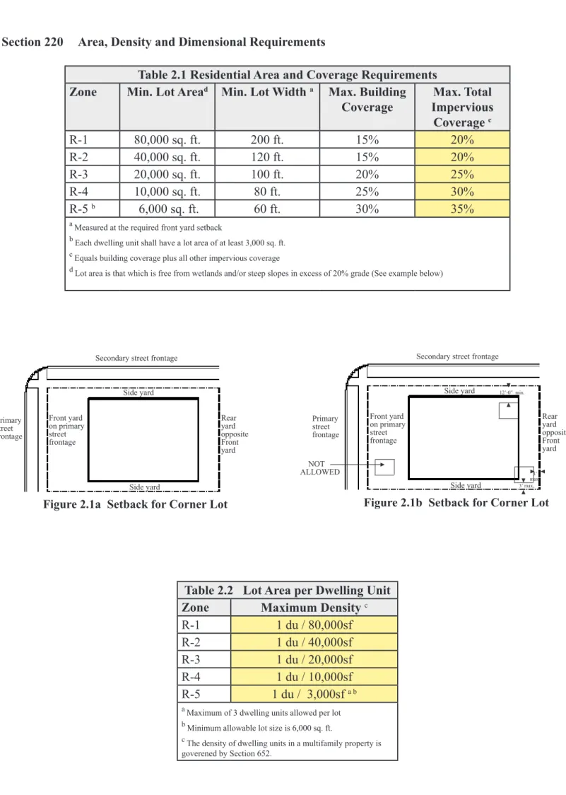
Section 220 Area, Density and Dimensional Requirements
Table 2.1 Residential Area and Coverage Requirements
Zone Min. Lot Aread Min. Lot Width a Max. Building
Coverage Impervious Max. Total Coverage c R-1 80,000 sq. ft. 200 ft. 15% 20% R-2 40,000 sq. ft. 120 ft. 15% 20% R-3 20,000 sq. ft. 100 ft. 20% 25% R-4 10,000 sq. ft. 80 ft. 25% 30% R-5 b 6,000 sq. ft. 60 ft. 30% 35%
a Measured at the required front yard setback
b Each dwelling unit shall have a lot area of at least 3,000 sq. ft. c Equals building coverage plus all other impervious coverage
d Lot area is that which is free from wetlands and/or steep slopes in excess of 20% grade (See example below)
Table 2.2 Lot Area per Dwelling Unit
Zone Maximum Density c
R-1 1 du / 80,000sf
R-2 1 du / 40,000sf
R-3 1 du / 20,000sf
R-4 1 du / 10,000sf
R-5 1 du / 3,000sf a b
a Maximum of 3 dwelling units allowed per lot b Minimum allowable lot size is 6,000 sq. ft.
c The density of dwelling units in a multifamily property is
goverened by Section 652. Front yard on primary street frontage Side yard Rear yard opposite Front yard Side yard
Figure 2.1a Setback for Corner Lot
Primary street frontage
Secondary street frontage
Front yard on primary street frontage Side yard Rear yard opposite Front yard Side yard
Figure 2.1b Setback for Corner Lot
Primary street frontage
Secondary street frontage
NOT ALLOWED 12’-0” min. 3’ max, 3’ max.
EXAMPLE: Lot Area Calculation Total Land Area
minus Wetlands
minus Slopes Exceeding 20% grade Lot Area
80,000 sf -10,000 sf -10,000 sf 60,000 sf This lot would be a legal and conforming lot in an R-2 zone, but not an R-1.
Table 2.3 Residential Yard and Height Requirements for PRIMARY STRUCTURES
Zone from Street LineMin. Front Yard a b from Centerline Min. Front Yard a c Min. Side Yard Min. Rear Yard Max. Height
R-1 50 ft.ab 75 ft. ac 30 ft. 50 ft. 35 ft.
R-2 40 ft. ab 65 ft. ac 20 ft. 40 ft. 35 ft.
R-3 40 ft. ab 65 ft. ac 15 ft. 40 ft. 35 ft.
R-4 25 ft. ab 50 ft. ac 12 ft. 25 ft. 35 ft.
R-5 20 ft. ab 45 ft. ac 10 ft. 25 ft. 35 ft.
a On a corner lot, one front yard is required on the primary street frontage, and one side yard is required on the other yard adjacent to the secondary street. The yard
opposite the designated front yard shall be the rear yard and the remaining yard a side yard. The front yard shall be as required by the applicable zone.
b Where street lines have been established.
c From center line of the right-of-way where street lines have not been established.
Table 2.4 Residential Yard and Height Requirements for ACCESSORY STRUCTURES located within a rear yard setback a
Zone Min. Side Yard a Min. Rear Yard Max. Height R-Zones 3 ft. 3 ft. 15 ft.
a No swimming pool, tennis court, or other recreational
structure, including related improved areas, shall be permitted in any required side or front yard of any residential zone.
Table 2.5 Residential Yard and Height Requirements for
ACCESSORY STRUCTURES
NOT located within a rear yard setback a
Zone Min. Front
Yard a Min. Rear Yard Max. Height
R-Zones 12 ft. + the required building setback Same as Primary Structure 15 ft.
a No swimming pool, tennis court, or other recreational structure, including related
improved areas, shall be permitted in any required side or front yard of any residen-tial zone.
This page intentionally
left blank
ARTICLE III TRANSECT ZONES T1 - T5 AND SPECIAL DISTRICTS
Section 300 PURPOSE
The purpose of this section is to enable and encourage the implementation of the following poli-cies with the use of Transect Zones throughout the Town:
a. Future development in neighborhoods and regional centers shall be compact, pedestrian-oriented and mixed-use;
b. Ordinary activities of daily living should occur within walking distance of most dwellings, allowing independence to those who do not drive;
c. Interconnected networks of streets should be designed to disperse traffic and reduce the length of automobile trips;
d. Within neighborhoods, a range of housing types and price levels should be provided to ac-commodate diverse ages and incomes;
e. Civic, institutional and commercial activity should be embedded in downtowns, not isolated in remote single-use complexes;
f. Schools should be sized and located to enable children to walk or bicycle to them;
g. A range of open space including parks, squares and playgrounds should be distributed be-tween neighborhoods. T1 NATURAL ZONE T2 RURAL ZONE T3 SUB-URBAN ZONE T4 GENERAL URBAN ZONE T5 URBAN CENTER ZONE T3.5
T1
T-1 NATURALT-1 Natural Zone consists of lands approximating or reverting to a wilderness condition, including lands unsuitable for settlement due to topography, hydrology or vegetation.
General Character: Natural landscape with some agricultural use Building Placement: Not applicable
Frontage Types: Not applicable Typical Building Height: Not applicable Type of Civic Space: Parks, Greenways
T2
T-2 RURALT-2 Rural Zone consists of sparsely settled lands in open or cultivated states. These include woodland, agricultural land, grass-land, and irrigable desert. Typical buildings are farm-houses, agricultural build-ings, cabins, and villas.
General Character: Primarily agricultural with woodland & wetland and scattered buildings
Building Placement: Variable setbacks Frontage Types: Not applicable Typical Building Height: 1- to 2-Story Type of Civic Space: Parks, Greenways
T3
T-3 SUB-URBANT-3 Sub-Urban Zone consists of low density residential areas, adjacent to higher zones that some mixed use. Home occupations and outbuildings are allowed. Planting is naturalistic and setbacks are relatively deep. Blocks may be large and the roads irregular to accommo-date natural conditions.
General Character: Lawns, and landscaped yards surrounding detached single-family houses; pedestrians occasionally
Building Placement: Large and variable front and side yard setbacks Frontage Types: Porches, fences, naturalistic tree planting Typical Building Height: 1- to 2-1/2 story with some 3-story Type of Civic Space: Parks, Greenways
T4
T3.5 & T-4 GENERALURBAN
T3.5 & T-4 General Urban Zones consist of a mixed use but primarily residential urban fabric. They may have a wide range of building types: single, sideyard, & rowhouses. Setbacks & land-scaping are variable. Streets with curbs and sidewalks
define medium-sized blocks.
General Character: Mix of houses, townhouses & small apartment buildings, with scattered commercial activity; balance between landscape and buildings; presence of pedestrians
Building Placement: Shallow to medium front and side yard setbacks Frontage Types: Porches, fences, dooryards
Typical Building Height: 2- to 3-story Type of Civic Space: Squares, Greens
T5
T-5 URBAN CENTERT-5 Urban Center Zone con-sists of higher density mixed use building that
accommo-date etail, offices, rowhouses
and apartments. It has a tight network of streets, with wide sidewalks, steady street tree planting and buildings set close to the sidewalks.
General Character: Shops mixed with townhouses, larger apartment houses,
offices, workplace, and civic buildings; predominantly
attached buildings; trees within the public right-of-way; substantial pedestrian activity
Building Placement: Shallow setbacks or none; buildings oriented to the street
defining a street wall Frontage Types: Stoops, shopfronts, galleries Typical Building Height: 3- to 5-story with some variation
Type of Civic Space: Parks, plazas and squares, median landscaping
TRANSECT DESCRIPTIONS
Section 310 BUILDING LOCATION
310.1 Specific to zones T1, T2, T3, T3.5, T4, T5, M, TG, NC
a. Buildings in the T1 Zone are not permitted except for limited public use and utility purposes.
b. Newly platted lots shall be dimensioned according to Table 3.4 and relevant transect tables.
c. Principal building(s) shall be built with frontage along a public or private roadway, and outbuilding(s) shall be built to the rear of the principal building, and may be built on each lot as provided for in these Regula-tions.
d. Facades shall be built parallel to the street, as specified on Table 3.4 and relevant transect tables. Setbacks for principal buildings shall be as shown in Table 3.4 and relevant transect tables. In the case of an infill lot, setbacks shall match one of the existing adjacent setbacks.
e. Rear setbacks for outbuildings shall be a minimum of 12 feet measured from the centerline of the Rear Al-ley or Rear Lane easement. In the absence of a rear alAl-ley or rear lane, the rear yard setback shall be 5 feet from the rear property line.
310.2 Specific to zones T4 & T5
The Commission may, by Special Permit, allow an addition to an existing building which does not comply with the frontyard setback/build-to line as of the effective date of these Regulations. The resulting structure shall be in keeping with the intent of these Regulations and must comply with Section 530.3.
Section 320 BUILDING MASSING
320.1 General to zones T1, T2, T3, T3.5, T4, T5, M, TG, NC
a. Buildings on corner lots shall have two private frontages. Requirements for the second and third layers per-tain only to the principal frontage. Requirements for the first layer perper-tain to both frontages. (See Definitions for Lot Line and Layers).
b. The first story of all facades shall be glazed with clear glass no less than 30% and shall be glazed at least 70% if a shopfront.
c. Building heights and expression lines shall conform to Table 3.4.
d. Stories may not exceed 14 feet in height from finished floor to finished ceiling, except for a first floor com-mercial use, which shall be a minimum of 11 feet and may be a maximum of 25 feet. A single floor level exceeding 14 feet shall be counted as two (2) stories. Mezzanines extending beyond 33% of the floor area below shall be counted as an additional story.
e. In a parking structure or garage, each level counts as a single story regardless of its relationship to habitable stories.
f. Height limits may be increased by 15 feet for non-habitable spaces such as masts, chimney flues, water tanks, or elevator bulkheads.
g. A spire, tower or belfry on a religious institution or public building may exceed the height limitations of the underlying zone, but shall not:
i. Exceed the allowed height by more than 50 feet; ii. Exceed 10% of the roof area.
h. Building heights in T1, T2, T3, T3.5 or T4 zones shall not exceed 35 feet and shall be measured in accor-dance with these Regulations (SeeArticle VIII Definition for Building Height).
j. All rooftop mechanical units shall be screened from view from the ground and adjacent buildings of equal or lower height.
k. Sloped roofs are encouraged.
320.2 Specific to zones T3, T3.5, T4, M, TG, NC
a. No portion of the private frontage may encroach on the sidewalk. b. Open porches may encroach on the first layer by 50% of its depth.
c. Balconies, open porches and bay windows may encroach on the first layer by 50% of its depth. 320. Specific to zones T5, M, TG, NC
a. Awnings, arcades, and galleries may encroach on the sidewalk to within 2 feet of the curb but must clear the sidewalk vertically by at least 8 feet and shall not exceed 14 feet in height.
b. Stoops, lightwells, balconies, bay windows, and terraces may encroach on the first layer 100% of its depth. c. Loading docks and service areas shall not be permitted in first layer.
d. In the absence of a building facade along any part of a frontage line, a streetscreen shall be built in the same plane as the facade.
e. Streetscreens should be at 3-1/2 and 4-1/2 feet in height. The streetscreen may be replaced by a hedge or fence. Streetscreens shall have openings no larger than necessary to allow for pedestrian and one-way auto-mobile access.
f. First floor residential or lodging use shall be raised a minimum of 2 feet from the average sidewalk grade. Section 330 SPECIAL REQUIREMENTS T3.5, T4, T5, M, TG, NC
Unless otherwise approved by the Commission, the following special requirements in the Transect Zones or Special District shall be required:
Shopfront: A shopfront facade shall be provided on average every 30’ along the frontage. The shopfront shall be no less than 70% glazed in clear glass and shaded by an awning overlapping the sidewalk as generally illus-trated in Table of Private Frontages and as specified in Article III. The first floor shall be confined to retail use for a minimum depth of 20 feet from the frontage line within the first story. Lobbies for hotels, offices and mul -tiple family dwellings may be considered as part of the required retail frontage, provided that any such lobby occupies no more than 50% of said building.
The Commission may require Cross Block Passages to ensure safe and convenient pedestrian and bicycle circu-lation.
Section 340 BUILDING USE
340.1 Specific to zones T2, T3, T3.5, T4, T5, M, TG, NC
a. Building uses in each Transect Zone shall conform to the uses on Table 6.1.
b. Accessory uses of lodging or office shall be permitted within an outbuilding. SeeTable 6.1.
340.2 Specific to zones T3.5, T4, T5, M, TG, NC
a. First story commercial uses shall be permitted.
350.1 Specific to zones T2, T3, T3.5, M, TG, NC
a. Density on a lot shall be determined by the actual parking provided within the lot as applied to the uses per-mitted in Table 6.1, as well as landscaping, open space, building coverage and pervious surface regulations.
350.2 Specific to zones T4, T5, M, TG, NC
a. Maximum density on a parcel shall be determined by the availability of effective parking in conjunction with Table 3.4 as it may apply. Such parking shall be provided:
i. Within the lot;
ii. Along the parking lane corresponding to the lot frontage, or; iii. By purchase or lease for 25 years from a parking lot within 300 feet;
iv. In a public parking garage or lot available within 300 feet of the property line.
b. Parking requirements shall be adjusted according to the shared parking factor of Table 3.2 to determine the effective parking. The shared parking factor is available for any combination of uses within any pair of adjacent blocks.
c. Based on the effective parking available, the density of the projected use shall be determined according to Table 3.1 and Table 3.2.
d. At the discretion of the Commission, the effective parking may be further reduced by up to 30% within a Transit-Oriented Development (TOD).
e. Liner buildings that are less than 30 feet deep and no more than two stories shall be exempt from parking requirements.
350.3 Specific to zones T2, T3, T3.5, T4, T5, M, TG, NC
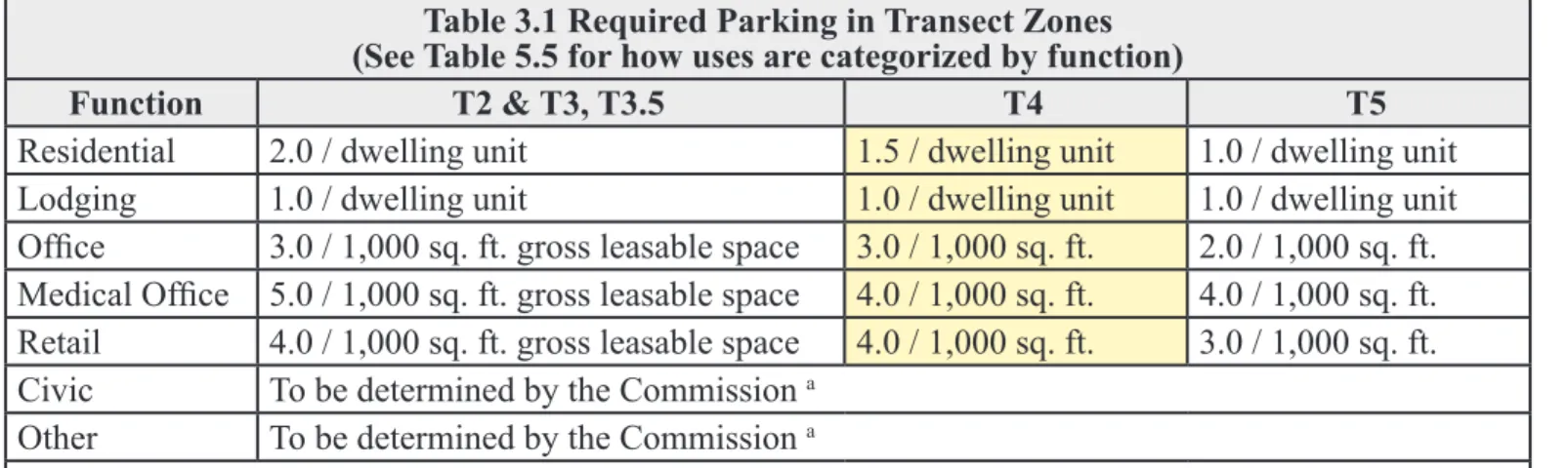
Parking calculations: Table 3.1 summarizes the parking requirement for each use by Transect Zone. This table also enables the calculation of allowable building square footage and the number of dwelling units allowed on each site given the parking available. To use the shared parking factor, divide the number of required parking spaces by the sharing factor to find the actual number of spaces required.
Table 3.1 Required Parking in Transect Zones
(See Table 5.5 for how uses are categorized by function)
Function t2 & t3, T3.5 t4 t5
Residential 2.0 / dwelling unit 1.5 / dwelling unit 1.0 / dwelling unit
Lodging 1.0 / dwelling unit 1.0 / dwelling unit 1.0 / dwelling unit
Office 3.0 / 1,000 sq. ft. gross leasable space 3.0 / 1,000 sq. ft. 2.0 / 1,000 sq. ft. Medical Office 5.0 / 1,000 sq. ft. gross leasable space 4.0 / 1,000 sq. ft. 4.0 / 1,000 sq. ft.
Retail 4.0 / 1,000 sq. ft. gross leasable space 4.0 / 1,000 sq. ft. 3.0 / 1,000 sq. ft.
Civic To be determined by the Commission a
Other To be determined by the Commission a
Table 3.2 Shared Parking Factor Example: T-4 Zone, Mixed-use building with 10,000
sf of office and 20 dwelling units. Office:
10,000 sf x 3 spaces / 1,000 sf = 30 spaces
Residential:
20 dwelling units x 1.5 spaces / dwelling = 30 spaces
Sub-Total:
30 spaces + 30 spaces = 60 required spaces TOTAL:
60 required spaces / 1.4 sharing factor = 43 actual spaces
Bicycle Parking Stalls:
43 actual spaces x 1 stall / 10 actual spaces
Sub-total = 4.3 bicycle stalls (always round up)
TOTAL = 5 bicycle stalls
---Projects meeting the requirements of a Transit Ori-ented Development:
43 actual spaces x 30% reduction factor = 13 actual spaces
+ 5.0 bicycle stalls
Section 360 PARKING LOCATION and PRIVATE ROADWAY STANDARDS
360.1 Specific to zones T1, T2, T3, T3.5, T4, T5, M, TG, NC
a. Where possible, parking shall be accessed by rear alleys or rear lanes.
b. Surface parking lots shall be masked from the frontage by a building or streetscreen.
360.2 Specific to zones T2, T3, M, TG, NC
a. Surface parking lots shall be located in the second and third lot layers. However, driveways, drop-offs and unpaved parking areas may be located in the first lot layer and shall be limited to five spaces. These five spaces may be used for temporary parking only.
b. Garages shall be located in the third layer. However, side- or rear-entry garages may be allowed in the first or second layer by Special Permit.
360.3 Specific to zones T3, T3.5, T4, M, TG, NC
a. Driveways at frontages of single-family residential uses shall be no wider than 12 feet in the first layer. b. Driveways at frontages of mixed-use and/or non-residential uses shall be no wider than 18 feet in the first
SHARED PARKING FACTOR
Function with Function
RESIDENTIAL RESIDENTIAL LODGING LODGING OFFICE OFFICE RETAIL 1.4 1.1 RETAIL 1.2 1.7 1.3 1.2 1.1 1.4 1.2 1 1 1 1 1.7 1.3 1.2
When three functions share park-ing, the lowest Shared Parking Factor shall be used to assure that there is enough parking.
layer.
360.4 Specific to zones T3.5, T4, M, TG, NC
a. All parking areas and garages shall be located in the third layer.
b. A minimum of one bicycle rack place shall be provided within the public or private frontage for every ten actual vehicular parking spaces.
360.5 Specific to zones T5, M, TG, NC
a. All parking lots, garages, and parking structures shall be located in the third layer.
b. Vehicular entrances and exits to parking lots, garages, and parking structures shall be no wider than 18 feet at the frontage.
c. Pedestrian exits from all parking lots, garages, and parking structures shall be directly to a frontage line (i.e., not directly into a building) except on underground levels that may be exited by pedestrians directly into a building.
d. A minimum of one bicycle rack place shall be provided within the public or private frontage for every ten actual vehicular parking spaces.
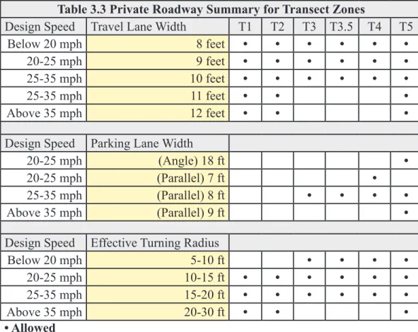
Table 3.3 Private Roadway Summary for Transect Zones
Design Speed Travel Lane Width T1 T2 T3 T3.5 T4 T5
Below 20 mph 8 feet • • • • • •
20-25 mph 9 feet • • • • • •
25-35 mph 10 feet • • • • • •
25-35 mph 11 feet • • •
Above 35 mph 12 feet • • •
Design Speed Parking Lane Width
20-25 mph (Angle) 18 ft •
20-25 mph (Parallel) 7 ft •
25-35 mph (Parallel) 8 ft • • • •
Above 35 mph (Parallel) 9 ft •
Design Speed Effective Turning Radius
Below 20 mph 5-10 ft • • • •
20-25 mph 10-15 ft • • • • • •
25-35 mph 15-20 ft • • • • • •
Above 35 mph 20-30 ft • • •
• Allowed
Section 370 LANDSCAPE STANDARDS
370.1 Specific to zones T2, T3, T3.5, T4, M, TG, NC
The first layer may not be paved, except for sidewalks and driveways as specified in Section 360. 370.2 Specific to zones T1, T2, TG
thereof.
b. Trees may be of single or multiple species as shown on Table 5.2. c. Trees shall be naturalistically clustered.
370.3 Specific to zones T3, T3.5, T4, M, NC
a. A minimum of one tree shall be planted within the first layer for each 30 feet of frontage line or portion thereof. b. Trees shall be a single species to match the species of street trees on the public frontage, or as shown on Table
5.2.
370.4 Specific to zones T5
a. Trees shall not be required in the first layer.
a. Edgeyard: Specific Types - single family House, cottage, villa, estate house, urban
villa. A building that occupies the center of its Lot with Setbacks on all sides. This is the least urban of types as the front yard sets it back from the Frontage, while the side
yards weaken the spatial definition of the public Thoroughfare space. The front yard is
intended to be visually continuous with the yards of adjacent buildings. The rear yard can be secured for privacy by fences and a well-placed Backbuilding and/or Outbuilding.
T2
T3
T4
b. Sideyard: Specific Types - Charleston single house, double house, zero lot line house,
twin. A building that occupies one side of the Lot with the Setback to the other side.
A shallow Frontage Setback defines a more urban condition. If the adjacent building is
similar with a blank side wall, the yard can be quite private. This type permits system-atic climsystem-atic orientation in response to the sun or the breeze. If a Sideyard House abuts a neighboring Sideyard House, the type is known as a twin or double House. Energy costs, and sometimes noise, are reduced by sharing a party wall in this disposition.
T4
T5
c. Rearyard: Specific Types - Townhouse, Rowhouse, Live-Work unit, loft building,
Apartment House, Mixed Use Block, Flex Building, perimeter Block. A building that occupies the full Frontage, leaving the rear of the Lot as the sole yard. This is a very
urban type as the continuous Facade steadily defines the public Thoroughfare. The
rear Elevations may be articulated for functional purposes. In its Residential form, this type is the Rowhouse. For its Commercial form, the rear yard can accommodate substantial parking.
T4
T5
d. Courtyard: Specific Types - patio House. A building that occupies the boundaries of its Lot while internally defining one or more private patios. This is the most urban of types, as it is able to shield the private realm from all sides while strongly defining the
public Thoroughfare. Because of its ability to accommodate incompatible activities, masking them from all sides, it is recommended for workshops, lodging and schools. The high security provided by the continuous enclosure is useful for crime-prone areas.
T5
e. Specialized: A building that is not subject to categorization. Buildings dedicated to manufacturing and transportation are often distorted by the trajectories of machinery. Civic buildings, which may express the aspirations of institutions, may be included.
SD
BUILDING LOCATION
Building Location. This table approximates the location of the structure relative to the boundaries of each individual Lot, establishing suitable basic building types for each Transect Zone.
SECTION PLAN LOT PRIVATE FRONTAGE ► ► ◄◄ R.O.W. PUBLIC FRONTAGE LOT PRIVATE FRONTAGE ► ►◄◄ R.O.W. PUBLIC FRONTAGE
Common Yard: A planted frontage wherein the facade is set back substantially from the frontage line. The front yard created remains unfenced and is visually continuous with adjacent yards, supporting a common landscape. The deep setback provides a buffer from the higher speed thoroughfares.
T2
T3
Porch & Fence: A planted frontage wherein the facade is set back from the frontage line with an attached porch permitted to encroach. A
fence at the frontage line maintains street spatial definition. Porches
shall be no less than 8 feet deep.
T3
T4
Terrace or Lightwell: A frontage wherein the facade is set back from the frontage line by an elevated terrace or a sunken lightwell. This type buffers residential use from urban sidewalks and removes the private yard from public encroachment. Terraces are suitable for conversion to outdoor cafes. Syn: Dooryard.
T4
T5
Forecourt: A Frontage wherein a portion of the facade is close to the frontage line and the central portion is set back. The forecourt cre-ated is suitable for vehicular drop-offs. This type should be alloccre-ated in conjunction with other frontage types. Large trees within the forecourts may overhang the sidewalks.
T4
T5
Stoop: A frontage wherein the facade is aligned close to the frontage line
with the first story elevated from the sidewalk sufficiently to secure
privacy for the windows. The entrance is usually an exterior stair and
landing. This type is recommended for ground-floor residential use.
T4
T5
Shopfront: A frontage wherein the facade is aligned close to the front-age line with the building entrance at sidewalk grade. This type is conventional for retail use. It has a substantial glazing on the sidewalk level and an awning that should overlap the sidewalk to within 2 feet of the curb. Syn: Retail Frontage.
T4
T5
Gallery: A frontage wherein the facade is aligned close to the frontage line with an attached cantilevered shed or a lightweight colonnade overlapping the sidewalk. This type is conventional for retail use. The gallery shall be no less than 10 feet wide and should overlap the sidewalk to within 2 feet of the curb.
T4
T5
Arcade: A colonnade supporting habitable space that overlaps the sidewalk, while the facade at sidewalk level remains at or behind the frontage line. This type is conventional for retail use. The arcade shall be no less than 12 feet wide and should overlap the sidewalk to within 2 feet of the curb.
T5
PRIVATE FRONTAGES
Private Frontages. The Private Frontage is the area between the building Facades and the Lot lines.
T3.5 T3.5
T3.5
T3.5
Park: A natural preserve available for unstructured recre-ation. A park may be independent of surrounding building frontages. Its landscape shall consist of Paths and trails, meadows, waterbodies, woodland and open shelters, all naturalistically disposed. Parks may be lineal, following the trajectories of natural corridors. The minimum size shall be 8 acres. Larger parks may be approved by Site Plan and Special Permit.
Green: An open space, available for unstructured recreation. A green may be spatially defined by landscaping and/or building frontages. Its landscape shall consist of lawn and trees, naturalistically disposed. The minimum size shall be 1/2 acre and the maximum shall be 8 acres.
Square: An open space available for unstructured recreation and civic purposes. A square is spatially defined by build -ing frontages. Its landscape shall consist of paths, lawns and trees, formally disposed. Squares shall be located at the intersection of important thoroughfares. The minimum size shall be 1/2 acre and the maximum shall be 5 acres. Plaza: An open space available for civic purposes and
commercial activities. A plaza shall be spatially defined by building frontages. Its landscape shall consist primarily of pavement. Trees are optional. Plazas should be located at the intersection of important streets. The minimum size shall be 1/2 acre and the maximum shall be 2 acres. Playground: An open space designed and equipped for the
recreation of children. A playground should be fenced
and may include an open shelter. Playgrounds shall be interspersed within Residential areas and may be placed within a block. Playgrounds may be included within parks and greens. There shall be no minimum or maximum size.
T1
T2
T3
T3
T4
T5
T5
T4
T5
T1
T2
T3
T4
T5
CIVIC SPACES
T3.5 T3.5 T3.5 T3.5T3
T3
BUILDING HEIGHT
Principal Building 35’-0”max.
Outbuilding 20’-0”max.
BUILDING LOCATION: SEE TABLE 3.5 SETBACKS - PRINCIPAL BUILDING (g.1) Front Setback Principal 24 ft. min (g.2) Front Setback Secondary 12 ft min.
(g.3) Side Setback 12 ft min.
(g.4) Rear Setback 12 ft min.
Frontage Buildout 40% min at front lot line
SETBACKS - OUTBUILDING
(h.1) Front Setback 20 ft. min. + bldg setback
(h.2) Side Setback 3 ft.
(h.3) Rear Setback* 3 ft. min*
PRIVATE FRONTAGES : SEE TABLE 3.5 *or 15 ft. from center line of alley
BUILDING HEIGHT
1. Building height shall be measured in number of feet.
2. Stories may not exceed 14 feet
in height from finished floor to finished ceiling, except for a first floor commercial function which
must be a minumum of 11 ft with a maximum of 25 feet.
3. Where surrounding buildings are typically more than one story and/
or where the usable floor area is
at least 2,500 sf, new structures shall be a minimum of two stories.
SETBACKS - PRINCIPAL BLDG
1. The facades and elevations of principal buildings shall be distanced from the lot lines as shown. 2. Facades shall be built
along the principal front-age to the minimum
speci-fied width in the table.
SETBACKS-OUTBUILD-ING
1. The elevation of the out-building shall be distanced from the lot lines as shown.
PARKING PLACEMENT
Covered and uncovered parking spaces may be provided within the second and third layer as shown in the diagram
TRASH PLACEMENT 2 1 M a x . h e i g h t 35’-0” Max. height 20’-0” 1 2 (g.1) (g.2)
(g.4) Corner LotCondition
Mid-Block Condition Corner Lot Condition Mid-Block Condition (h.3) (h.1) (h.2) (g.4) (g.1) (h.1) (h.3) Secondary Front-Principal Frontage
FORM-BASED CODE GRAPHICS - T3 & T3.5
2nd Layer 1st Layer Front Yard Setbac, Principal Building 3rd Layer 20 ft T3.5 (g.3) (h.2)
BUILDING HEIGHT
1. Building height shall be measured in number of feet.
2. Stories may not exceed 14 feet in height from
finished floor to finished
ceiling, except for a first floor Commercial func -tion which must be a minumum of 11 ft with a
maximum of 25 ft.
3. Buildings shall have an Expression Line on the exterior facade at the top of the 2nd story level.
SETBACKS - PRINCIPAL BLDG
1. The facades and eleva-tions of principal build-ings shall be distanced from the lot lines as shown.
2. Facades shall be built along the principal front-age to the minimum specified width in the table.
SETBACKS - OUTBUILDING
1. The elevations of the outbuilding shall be dis-tanced from the lot lines as shown.
PARKING PLACE-MENT
Covered and uncovered parking spcovered and unces may be provided within the 3rd layer.
TRASH PLACEMENT
Trash containers shall be stored within the 3rd layer. (See also Section 520.7.1)
T4
)
BUILDING HEIGHT
Principal Building 2 stories min /35’max
Outbuilding 20’-0” max.
BUILDING LOCATION
Edgeyard permitted
Sideyard permitted
Rearyard permitted
Courtyard not permitted
SETBACKS - PRINCIPAL BUILDING (g1) Front Setback Principal 6 ft. min. 18 ft. max (g2) Front Setback Secondary 6 ft. min. 18 ft. max
(g3) Side Setback 0 ft. min.
(g4) Rear Setback 5 ft. min.*
Frontage Buildout 60% min at setback
SETBACKS - OUTBUILDING
(h1) Front Setback 20 ft.min.+bldg. setback
(h2) Side Setback 3ft at corner
(h3) Rear Setback 3 ft. min
PRIVATE FRONTAGES**
Common Lawn not permitted
Porch & Fence permitted
Terrace or Light Court permitted
Forecourt permitted
Stoop permitted
Shopfront & Awning permitted
Gallery permitted
Arcade not permitted
*or 15 ft. from center line of alley
”N” stands for any Stories above those shown, up to the maximum. Refer to metrics for exact minimums and maximums
** Any protrusion into the Town or State right-of-way will require approval from the appro-priate entity. Corner Lot Condition Mid-Block Condition 1 2 max. 2 min. 1 3 max. Corner Lot Condition Mid-Block Condition 2nd Layer 1st Layer Front Yard Setback
Principal Building 3rd Layer Secondary Front-Principal Frontage Max. height 35’-0” Max. height 20’-0”
FORM-BASED CODE GRAPHICS - T4
(g.1) (g.1) (g.2) (g.4) (h.3) (h.1) (h.2) (g.4) (h.1) (h.3) 20 ft Expression Line (h.3) (g.3)
BUILDING HEIGHT
1. Building height shall be measured in number of feet.
2. Stories may not exceed 14 feet in height from
finished floor to finished
ceiling, except for a first floor commercial func -tion which must be a minumum of 11 ft with a
maximum of 25 ft.
3. Buildings shall have an Expression Line on the exterior facade at the top of the 2nd story level.
SETBACKS - PRINCIPAL BLDG
1. The facades and eleva-tions of principal build-ings shall be distanced from the lot lines as shown.
2. Facades shall be built along the principal front-age to the minimum
specified width in the
table.
SETBACKS - OUTBUILDING
1. The outbuilding, relative to the property llines, shall be located as shown.
PARKING PLACEMENT
Covered and uncovered parking spaces may be provided within the 3rd layer as shown in the diagram.
TRASH PLACEMENT
Trash containers shall be stored within the 3rd layer. (See also Section 520.7.1)
T5
BUILDING HEIGHT
Principal Building 5 stories max. / 2 min.
Outbuilding 2 stories max.
BUILDING LOCATION
Edgeyard not permitted
Sideyard permitted
Rearyard permitted
Courtyard permitted
SETBACKS - PRINCIPAL BUILDING
(g.1) Front Setback Principal 0 ft. min. 12 ft. max. (g.2) Front Setback Secondary 0 ft. min. 12 ft. max.
(g.3) Side Setback 0 ft. min. 24 ft. max.
(g.4) Rear Setback 5 ft. min.*
Frontage Buildout 80% min at setback
SETBACKS - OUTBUILDING
(h.1) Front Setback 40 ft. max. from rear prop.
(h.2) Side Setback 0 ft. min. or 2 ft at corner
(h.3) Rear Setback 3 ft. max.
PRIVATE FRONTAGES**
Common Lawn not permitted
Porch & Fence not permitted
Terrace or Light Court permitted
Forecourt permitted
Stoop permitted
Shopfront & Awning permitted
Gallery permitted
Arcade permitted
*or 15 ft. from center line of alley
”N” stands for any stories above those shown, up to the maximum. refer to metrics for exact minimums and maximums
** Any protrusion into the Town or State right-of-way will require approval from the appropriate entity.
1 2 2 min. 1 N Corner Lot Condition Mid-Block Condition 40 ft. max. 5 story max. Corner Lot Condition Mid-Block Condition Principal Frontage Secondary Front-Max. height 60’-0” Max. height na
FORM-BASED CODE GRAPHICS - T5
2nd Layer 1st Layer Front Yard Setback Principal Building 3rd Layer 20 ft (g.1) (g.1) (g.2) (g.4) (h.1) (h.2) (g.4) (h.1) (h.3) Expression Line (g.3)
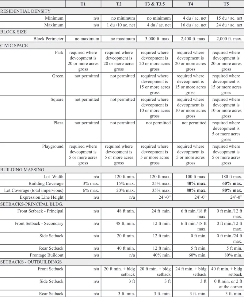
Table 3.4 Summary of Transect Zones
t1 t2 t3 & t3.5 t4 t5
RESIDENTIAL DENSITY
Minimum n/a no minimum no minimum 4 du / ac. net 15 du / ac. net
Maximum n/a 1 du /10 ac. net 4 du / ac. net 16 du / ac. net 24 du / ac. net
BLOCK SIZE
Block Perimeter no maximum no maximum 3,000 ft. max. 2,400 ft. max. 2,000 ft. max.
CIVIC SPACE
Park required where deveopment is 20 or more acres gross required where deveopment is 20 or more acres gross required where deveopment is 20 or more acres gross required where deveopment is 20 or more acres gross required where deveopment is 20 or more acres gross
Green not permitted not permitted required where
deveopment is 15 or more acres gross required where deveopment is 15 or more acres gross required where deveopment is 15 or more acres gross
Square not permitted not permitted required where
deveopment is 10 or more acres gross required where deveopment is 10 or more acres gross required where deveopment is 10 or more acres gross
Plaza not permitted not permitted not permitted not permitted required where
deveopment is 5 or more acres
gross Playground required where
deveopment is 5 or more acres gross required where deveopment is 5 or more acres gross required where deveopment is 5 or more acres gross required where deveopment is 5 or more acres gross required where deveopment is 5 or more acres gross BUILDING MASSING
Lot Width n/a 120 ft min. 120 ft max. 100 ft max. 180 ft max.
Building Coverage 3% max. 15% max. 25% max. 40% max. 60% max.
Lot Coverage (total impervious) 6% max. 20% max. 35% max. 80% max. 80% max.
Expression Line Height n/a n/a 24’-0” 24’-0” 24’-0”
SETBACKS-PRINCIPAL BLDG.
Front Setback - Principal n/a 48 ft min. 24 ft min. 6 ft min./18 ft
max. 0 ft min./12 ft max.
Front Setback - Secondary n/a 48 ft. min. 12 ft min. 6 ft min./18 ft
max. 0 ft min./12 ft max.
Side Setback n/a 20 ft min. 12 ft min. 0 ft min. 0 ft min./24 ft
max.
Rear Setback n/a 40 ft min. 12 ft min. 5 ft min. 5 ft min.
Frontage Buildout n/a n/a 40% min. 60% min. 80% min.
SETBACKS - OUTBUILDINGS
Front Setback n/a 20 ft min. + bldg
setback 20 ft min. + bldg setback 24 ft min. + bldg setback 40 ft min. + bldg setback
Side Setback n/a 3 ft 3 ft 3 ft 0 ft min. or 2 ft
at the corner
Table 3.4 Summary of Transect Zones
t1 t2 t3 & t3.5 t4 t5
BUILDING LOCATION
Edgeyard permitted permitted permitted permitted not permitted
Sideyard not permitted not permitted not permitted permitted permitted
Rearyard not permitted not permitted not permitted permitted permitted
Courtyard not permitted not permitted not permitted not permitted permitted
PRIVATE FRONTAGES*
Common Yard n/a permitted permitted not permitted not permitted
Porch & Fence n/a not permitted permitted permitted not permitted
Terrace or Light Court n/a not permitted not permitted permitted permitted
Forecourt n/a not permitted not permitted permitted permitted
Stoop n/a not permitted not permitted permitted permitted
Shopfront & Awning n/a not permitted not permitted permitted permitted
Gallery n/a not permitted not permitted permitted permitted
Arcade n/a not permitted not permitted not permitted permitted
BUILDING HEIGHT
Principle Building
(Also see Section 530.4) n/a 35’-0” max 35’-0” max 35’-0” max 60’-0” max
Outbuilding n/a 20’-0” max.
1 story min. 2 stories max. 20’-0” max. 1 story min. 2 stories max. 20’-0” max. 2 story min. 2 stories max. 20’-0” max. 2 story min. 2 stories max. * Any protrusion into the Town or State right-of-way will require approval from the appropriate entity.
Section 380 SPECIAL DISTRICTS See TABLE 6.1 for allowed uses.
The Commission shall designate areas as Special Districts that, by their intrinsic size, function, or configuration, cannot conform to the requirements of any Transect Zone or combination of zones. Conditions of development for new Special Districts shall be determined by amendment to these regulations and shall be consistent with the most recently adopted Plan of Conservation and Development as it may have been amended from time to time. 380.1 Manufacturing Zone
Purpose
The purpose of the Manufacturing Zone is to provide for a broad range of industrial and commercial uses in an open setting that will not have environmentally objectionable influences on adjoining residential and business zones.
Table 3.5 Lot and Building Requirements for Manufacturing District Zone Min. Lot
Area Max. Height Max. % Building Coverage
Max. % Impervious Surface
Lot
Width Frontage Buildout Front Yard Setback Side Yard Setback Rear Yard Setback
M 20,000 sf 40’-0” 40% 60% 100 ft 80% min. 25 ft max. 10 ft min. 25 ft min.
If a building is set back from the front lot line by 25 feet or more, there shall be: a. A landscaped area at least 10 feet wide abutting the front of the building; and,
b. A landscaped strip of not less than 5 feet wide along and contiguous to the front lot line of the property, or; c. An equal amount of landscaped area acceptable to the Commission in another location on the site.
380.2 Newhall Center 380.2.1 Purpose
The purpose of the Newhall Center Zone is to improve the existing character of the area by:
a. Making the neighborhood complete by allowing for a mix of uses for living, playing and learning;
b. Providing for alternatives to the automobile by improving safe access within and through the neighborhood for drivers, bicyclists and pedestrians;
c. Developing in harmony with natural systems by employing sustainable, green technologies and land-use practices;
d. Raising the value of existing properties by combining remediation and redevelopment efforts;
e. Meeting the housing needs of the neighborhood by including new housing to replace homes lost due to structural damage, as well as providing additional housing for families and elderly residents;
f. Coordinating the environmental remedy and redevelopment of infrastructure;
g. Honoring the spirit of the neighborhood by creating a sustainable village atmosphere;
h. Locating parks, neighborhood amenities, aesthetic streetscapes, native habitat areas and community gardens that will enhance the quality of life for the area residents.
Table 3.6 Lot and Building Requirements for Newhall Center District Zone Min. Lot
Area Max. Height Max. % Building Coverage
Max. % Impervious Surface
Lot
Width Front Yard Side Yard Rear Yard
380.3 Town Green District
380.3.1 Purpose
The Town Green District is a multi-use zone designed to allow for centrally located public and civic purposes and amenities that are accessible and beneficial to all residents of the community.
The Zone allows for the following public and civic amenities:
a. Open space land for a Town Center Park/Green to be used for passive recreation and community events; b. Multi-faceted athletic facilities for active recreation;
c. Undisturbed areas of natural and scenic beauty; d. Bird and wildlife sanctuary areas;
e. A Town public educational facility; and
f. An area for arts, historic and visitor displays and instruction.
380.3.2 Special Standards
At least 80% of the Zone will be maintained as open space, park or recreation or wildlife and bird sanctuary use. Table 3.7 Lot and Building Requirements for Town Green District
Zone Max. Height Front Yarda Min. Side Yard Min. Rear Yard
TG 40’-0” 50 ft min 50’-0” 50’-0”
a Public school shall have a front yard minimum setback of 100 feet.
380.3.3 Uses Permitted Subject to Site Plan Approval
The following uses are permitted uses subject to site plan approval: a. Community events, Active recreational uses;
b. Passive recreational uses;
c. Walking and biking trails and paths;
d. Historical structures, monuments, flag poles and public art; e. Wildlife and bird sanctuary; and
f. Customary accessory uses.
380.3.4 Special Permit Uses
a. Town Park b. Town Green c. Museum d. Outdoor Cafe
e. Public schools of the Town of Hamden are allowed subject to Special Permit approval and Site Plan review provided the following conditions are also met:
i. The building footprint and the parking area of the facility, taken together, will not exceed 20% of the Zone;
ii. The facility is served by public water and public sanitary sewers;
iii. The facility will have a front yard minimum setback of 100 feet from the street; iv. The building will not exceed 40 feet in height; and
v. The facility shall have a vehicular access, traffic and parking pattern including provision
for student pick-up and drop-off by bus and parent so designed as to represent an effetive access, traffic and parking pattern that properly addresses the needs of public safety.
380.3.5 Zoning Permit Uses
a. Concerts and public festivals and events, including firework displays and farmers market; and b. Arts, historic or visitor displays or instruction.
This page intentionally
left blank
ARTICLE IV OVERLAY ZONES Section 400 Purpose
The purpose of an overlay zone is to impose additional requirements beyond those of the underlying zone in cases where additional safeguards are necessary.
Section 410 Aquifer Protection Area (APA)
(See Separate Regulations)
Section 420 Coastal Area Management Zone (CAM)
421 Purpose
The purpose of Coastal Site Plan Review is to assure that development within the Coastal Area is consistent with the goals and policies of the Coastal Area Management Act (Chapter 444, Section 22a-92 of the Connecti-cut General Statutes) and with the goals and policies of the Town of Hamden Planning and Zoning Commission. 422 Location
The Coastal Area shall be defined as the area of Hamden that lies within the Coastal Area boundaries described in Section 22a-94 (a), (b), (c) and (d) of the Connecticut General Statutes and as shown on a map titled "Coastal Boundary" 1980, as it may be amended from time to time, prepared by Coastal Area Management Program, Connecticut Department of Environmental Protection, which is on file in the Planning and Zoning Office and in the office of the Hamden Town Clerk.
423 Permitted Uses
In the Coastal Area, any use that is allowed in the underlying zone shall be permitted, subject to compliance with the requirements of all pertinent sections of these Regulations and all pertinent sections of the Connecticut General Statutes.
424 Authority
A Coastal Area Site Plan shall be approved by the Commission as outlined in Section II (b) of the Coastal Area Management Act prior to the commencement of any activity.
425 Exceptions
A Coastal Area Site Plan shall be required for any activity or project as defined in Section II (b) of the Coastal Management Act, which is proposed to be located either fully or partially within the Coastal boundary, with the following exceptions:
a. Minor additions to or modifications of existing buildings or detached accessory buildings, such as garages and utility sheds. A minor addition is an addition that does not exceed 10% of the first floor area or one-thousand square feet whichever is less, and which does not require more than a 10% addition to the number of off-street parking spaces in order to comply with the parking requirements;
b. Construction of new or modifications of existing on-premise fences, walls, pedestrian walks and terraces, underground utility connections, essential electric, gas, telephone, water and sewer service lines, signs and such other minor structures that will not substantially alter the natural character of coastal resources or restrict access along tidal rivers;
c. Construction of an individual, conforming, single-family residential structure, except in or within one hun-dred feet of tidal wetlands;
d. Activities conducted for the specific purpose of conserving or preserving soil, vegetation, water, fish, shell-fish, wildlife and other coastal land and water resources;