Road infrastructure planning using spatial tools
from a perspective of poverty reduction
Jacco Vosselman
Road infrastructure planning
using spatial tools from a
perspective of poverty
reduction
Road infrastructure planning
using spatial tools from a
perspective of poverty
reduction
Final Report
Date: December 11, 2009
Status: Final Report
Author: J.J. (Jacco) Vosselman
Civil Engineering and Management University of Twente
Supervision: Prof. Dr. Ir. M.F.A.M. (Martin) van Maarseveen University of Twente
Dr. Ir. M.H.P. (Mark) Zuidgeest University of Twente
Abstract
Road infrastructure planning is often believed to contribute to poverty reduction and many development bank and NGO’s invest time and money in these projects. However, few of those projects were subject of impact evaluations. Besides, feasibility studies are often based on financial criteria rather than economic, social or ecologic criteria (Van de Walle, 2009).
Keshkamat (Keshkamat, 2007) developed a method in which Spatial Multi Criteria Evaluation or SMCE can be used for route generation and selection. This has proven to be a successful method for the spatial planning of corridors that includes different stakeholder views and is capable of including economic, social and ecologic as well as technical criteria. The question therefore rises whether or not social criteria (especially poverty reduction as stated in the Millennium Development Goals) can be a useful addition to the SMCE method.
The research will be supported by a showcase of the Asian Highway Network. This international highway network will connect Asian countries. Focus will be on a stretch of road in Mongolia known as the Millennium Road or AH 32, which will run from the capital of Ulaanbaatar to Khovd in the western end of the country.
The main objective of the research is:
To analyse the potential of geospatial technologies and SMCE in the planning of highways as a means of contributing to MDG-1 (poverty reduction)
The literature review discusses three topics, road infrastructure planning, poverty and poverty reduction and SMCE. This showed that:
• The planning of road infrastructure derives from policy. Planning is often guided by a framework. The generation and selection of route alternatives is not guided by a framework nor is the process transparent.
• Poverty is a complex principle from which many definitions do exist. Poverty is both multidimensional and spatial. In literature, many links do exist between poverty reduction and road infrastructure planning. They can be summarized as that road infrastructure planning contributes to poverty reduction by creating better access to opportunities.
• The SMCE method is versatile. Research shows that it can be used with economic, ecologic technical and social criteria and it can be used for decision support for areas, corridors and networks. Furthermore, SMCE has been used for design and evaluation principles.
The conclusions that can be drawn from both theory and case research are that:
• It is possible to include poverty reduction criteria to the process of spatial multi criteria evaluation, by emphasizing on the location of poor people and their lack of access to opportunities.
• Planners should make use of SMCE to provide a holistic and transparent method for the planning of road infrastructure from a perspective of poverty reduction.
More research is needed on:
• The impact of geographical scale on the SMCE process. It is presumed that geographical scale plays a role in the SMCE process. Planning roads using SMCE on a local level is assumed to be different from planning on a national or international level. Since no considerations towards scale were made in this research, the impact should be topic of further research on road infrastructure planning using SMCE.
• The links between road infrastructure planning and poverty reduction. Current research is not supported by impact evaluations. This should be done to improve the links between road infrastructure planning and poverty reduction.
Abstract (Dutch)
Het wordt algemeen aangenomen dat het plannen van weginfrastructuur een positieve invloed heeft op armoede vermindering. Ontwikkelingsorganisaties steken daarom veel tijd en geld in infra-projecten. Dergelijke projecten zijn echter nog niet onderworpen aan impact evaluaties en haalbaarheidsstudies benadrukken vaak financiële haalbaarheid boven economische, ecologische of sociale haalbaarheid (Van de Walle, 2009).
Keshkamat (Keshkamat, 2007) heeft een methode ontwikkeld waarbij ruimtelijke multi criteria evaluatie kan worden gebruikt voor routeontwerp en routeselectie. Deze methode is succesvol bevonden voor de ruimtelijke planning van routes. De methode maakt het mogelijk om verschillende actoren en verschillende criteria (op economisch, ecologisch, sociaal en technisch gebied) mee te laten wegen in de ruimtelijke routekeuze. De vraagt rijst of sociale criteria zoals armoede vermindering ook toegevoegd kunnen worden aan deze methode.
Dit onderzoek wordt ondersteund door een casus van het Asian Highway Network. Dit is een internationaal snelwegennetwerk dat Aziatische landen verbindt. Specifiek wordt gekeken naar de AH32 of Millennium Road, dat een deel van het netwerk vormt en de hoofdstad van Mongolië, Ulaanbaatar, verbindt met de provinciehoofdstad Khovd.
De doelstelling in dit onderzoek luidt:
Een onderzoek naar de mogelijkheden van het gebruik van ruimtelijke multi criteria evaluatie bij het plannen van hoofdwegen met als doel het verminderen van armoede.
In het literatuuronderzoek zijn de concepten van planning, armoede en ruimtelijke multi criteria evaluatie onderzocht. Hieruit kwam naar voren dat.
• Het plannen van weginfrastructuur komt voort uit beleidsvorming en uitvoering. Planning wordt vaak gestructureerd uitgevoerd. Het ontwikkelen van en een keuze maken uit route alternatieven wordt voor zover onderzocht niet gestructureerd uitgevoerd.
• Armoede is een ingewikkeld begrip met vele definities. Armoede bestaat uit vele dimensies en is ruimtelijk uit te drukken. In de literatuur komen veel verbanden tussen armoede vermindering en het plannen van weginfrastructuur voor. Deze komen neer op dat planning van weginfrastructuur een positieve bijdrage levert aan de verbetering van toegang tot mogelijkheden.
• Ruimtelijke multi criteria evaluatie is een veelzijdige methode. Onderzoek laat zien dat economische, ecologische, technische en sociale criteria gebruikt kunnen worden en dat de methode toepasbaar is voor beslissingshulp voor zowel gebieden als voor routes. Verder is de methode zowel voor haalbaarheids- als voor evaluatieonderzoeken gebruikt.
• De planning van weginfrastructuur kan een positieve bijdrage leveren aan armoede vermindering door middel van het verbeteren van toegang tot mogelijkheden. Hierbij speelt de toegang tot werk een belangrijke rol.
• Het is mogelijk om criteria van armoede vermindering toe te voegen aan het ruimtelijk multi criteria evaluatie proces, door de locatie van de arme bevolking en het gebrek aan toegang tot mogelijkheden te benadrukken.
• Planners zouden gebruik moeten maken van ruimtelijke multi criteria evaluatie om zo een integrale en transparante methode te hebben voor het plannen van weginfrastructuur met armoede vermindering als doel.
Aanbevelingen voor verder onderzoek zijn:
• Onderzoek naar de impact die ruimtelijke schaalniveaus hebben op het proces. Aangenomen wordt dat ruimtelijke schaalniveaus wel degelijk een rol spelen in ruimtelijke Multi criteria evaluatie en dat het plannen van infrastructuur op een lokaal niveau met de methode om een andere aanpak vraagt dan het plannen van infrastructuur op een nationaal of internationaal niveau. Omdat dit onderzoek deze vraag heeft laten liggen kan het een onderwerp voor verder onderzoek zijn.
• De verbindingen tussen plannen van weginfrastructuur en armoede vermindering worden op dit moment niet ondersteund door onderzoek op het gebied van impact evaluaties. Dit is noodzakelijk om de verbindingen tussen planning en armoede vermindering te versterken.
Preface
This report is the result of my MSc research done from February to December 2009 in order to finish my studies on Civil Engineering and Management at the University of Twente in Enschede, the Netherlands. The research was done at the International Institute for Geo-Information Science and Earth Observation (ITC) in Enschede, the Netherlands.
This research will start with a background in chapter 1. Chapter 2 will discuss the research concept including the questions that have to be answered throughout this research. Chapter 3 will discuss the literature that serves as a background for this research. Three concepts will be subject of literature study. These are the planning of road infrastructure, poverty and poverty reduction in combination with road infrastructure and finally SMCE or Spatial Multi Criteria Evaluation. This chapter ends with a theoretical conclusion. Chapter 4 will elaborate on the first two topics of chapter 3, but then in a Mongolian context. Chapter 5 will elaborate on SMCE in the Mongolian context, i.e. an explanation of the model in 5 steps. Chapter 6 will present results followed by a critical discussion in chapter 7. Finally, chapter 8 will present conclusions and give recommendations for further research.
I could have not completed the process of doing the thesis without the help of many people. First, I would like to thank the graduation committee. First I would like to thank my professor, Martin van Maarseveen, for his good advice and overview on the thesis. I would like to thank Mark Zuidgeest for his critical views and remarks that kept me sharp, as well for keeping me motivated from time to time. I would like to thank Sukhad Keshkamat, for being a good teacher and for being so dedicated to the matter. Secondly, I would like to thank my friends and family for their unconditional support, not only during the last few months of my study, but throughout the more than 7 years of studying. Finally, I owe a big thank you to Anne, for receiving the unlimited supply of support, an occasional pep talk and a lot of love. Thanks to all.
Table of Contents
1 Background... 10
2 Research Concept... 12
2.1 Questions ... 12
2.2 Methodology ... 14
3 Literature review ... 17
3.1 Planning of road infrastructure and routing... 18
3.2 Accessibility, Poverty and Infrastructure ... 24
3.3 SMCE & Poverty & Transport ... 30
3.4 Conclusion ... 37
4 Description of study area... 38
4.2 Planning of road infrastructure and routing in Mongolia... 39
4.3 Poverty and Poverty Reduction in Mongolia ... 41
4.4 Conclusion ... 42
5 Research methodology ... 44
5.1 Introduction into the 5 step model ... 44
5.2 Stakeholder analysis [1]... 45
5.3 Extracting criteria and translating them into spatial constraints and factors [2] .... 50
5.4 Adding Poverty in GIS [3] ... 54
5.5 Collecting the data [4] ... 55
5.6 Constructing the SMCE model [5] ... 61
6 Results ... 65
6.1 Results of SMCE... 65
6.2 Results of the Least cost path analysis... 67
6.3 Route statistics ... 70
6.4 Performance analysis ... 71
6.5 Sensitivity analysis ... 73
7 Discussion and Reflection ... 75
7.1 Discussion on research topics ... 75
7.2 Discussion on research process ... 76
8 Conclusions & Recommendations ... 78
8.1 Conclusions ... 78
8.2 Recommendations for further research ... 79
1
Background
With the Millennium Development Goals or MDGs as clear goals for governments, Non Governmental Organizations (NGO’s) and financial institutions such as the World Bank or Asian Development Bank, the ability to measure their project outcomes in terms of these goals is crucial. An important type of projects that is often regarded as contributing to MDGs is the planning of road infrastructure in developing countries. The planning of (rural) road infrastructure is said to provide people with access to opportunities such as employment, education or healthcare. Many researchers have written about the positive effects of road infrastructure on the wellbeing of (rural) population. Gannon and Liu (Gannon & Liu, 1997) are describing the role of transport in poverty reduction as being a complementary one. Transport alone cannot reduce poverty. Gannon and Liu state that the strongest relation exists between transport and economic development. The ADB (ADB, 2006) did research on the questions how rural roads help reduce poverty and how rural road projects need to be designed accordingly. Rural road infrastructure improvement may have strong effects on changes in transportation services, changes in travel patterns, changes in village profiles, changes in income and welfare. The IFRTD (IFRTD, 2005) states that transport plays a key role in reaching alleviating poverty. According to IFRTD, investments in road infrastructure can be effective in lowering input prices, increasing agricultural production and reducing the monopoly power of agricultural traders by facilitating better access to markets.
However, as stated by Van de Walle (Van de Walle, 2009), only few of the aid-financed rural road projects in developing countries were subject to impact evaluations. Although many claims have been made on the positive impacts of road infrastructure, so far there has not been a proper research on the impacts of road infrastructure route planning. Feasibility studies are often based on financial criteria such as the Internal Rate of Return (IRR), Net Present Value (NPV) or vehicle operating cost (voc) savings without taking into account economic, ecologic or social criteria. Van de Walle recognizes that assessing the impacts of rural road projects is a very difficult task, but states that a credible rural road impact evaluation requires panel (with pre-intervention) data for project and appropriate non-project areas and other relevant data sources.
Keshkamat (Keshkamat, 2007) has already done research on the possibility of using spatial tools, specifically Spatial Multi Criteria Evaluation (SMCE) tool to improve the planning of (rural) road infrastructure. A SMCE is a powerful tool in a GIS environment which helps to make informed spatial decisions using multiple spatial criteria. By taking the views from several stakeholders and combining these into a set of spatial criteria values that influence the planning of road infrastructure, several alternatives can be developed with the possibility to estimate impacts beforehand. Keshkamat has proven this method to be successfully for a case study of the Via Baltica Highway in Poland.
adding an estimation of possible impacts beforehand, assessment can take place with the project after implementation.
This research will look at the possibilities of using geo-spatial tools and especially the use of SMCE in road infrastructure planning. It will investigate whether social criteria can be included in a SMCE as an addition to the economic and ecologic criteria that are already proven. It will look at the possibilities of including SMCE in feasibility studies as a tool to estimate the impacts that road infrastructure routing may have in terms of social impacts. It will therefore be guided by known effects many researchers have written about, such as the positive impacts of road infrastructure on MDG goals. The prime focus of this research will therefore be on MDG-1: the eradication of extreme poverty. However, when successful other goals such as the right to education and healthcare could also be estimated, whenever road infrastructure can contribute to these goals.
The research will be supported by a showcase of the Asian Highway Network. Currently the United Nations Economic and Social Commission for Asia and the Pacific (UNESCAP), together with countries in Asia and Europe, is working on a project to create an Asian Highway network; a network of highways crossing international borders such as there is in Europe (TEN-roads), the Americas (Pan-American Highways) or Africa (Trans-African highway project). One of those countries through which a cross border highway network will run is Mongolia, landlocked between Russia and China and the least populated country in the world. Three Asian Highways will run through Mongolia, of which the AH32 or Millennium Road will cross the country from east to west. This research will focus on this AH32, and in particular the part west from the capital of Ulaanbaatar, which connects to the AH4 in the regional capital of Khovd in the western end of the country. Currently, Keshkamat is doing a PhD research on developing a spatial decision support system for the environmental assessment, formulation and evaluation of optimal transport corridor alternatives in which this case is also used.
Keith Griffin (Griffin, 2001) mentions in the strategy for poverty reduction in Mongolia a few themes that are central in reducing poverty in the country. Among those are creating employment, the need for investment (in human, infrastructural and natural capital) and a decentralization of planning. This means that investments in road infrastructure in Mongolia could contribute to the country poverty reduction strategy as well.
It is expected that this research can contribute to the discussion on the links between road infrastructure planning and poverty reduction, and that it is possible to include poverty reduction criteria in the SMCE process.
2
Research Concept
The research plan consists of two parts. First the main research problem and research objective will be presented. Accordingly the questions that should be answered during this research and why these questions need to be answered will be discussed. The second part consists of a description of the research methodology. The research methodology will discuss how the research questions will be answered.
As seen in the previous chapter, one of the main problems is that the current procedure of route planning is disputable, especially in the context of planning for poverty reduction. SMCE could be a way of improving the route generation and selection of road infrastructure. Therefore, the main objective of the research has been formulated as:
The next step is the development of research questions, in which the main research questions and supportive questions will be proposed.
2.1
Questions
The first step of the research is the formulation of a main research question. In fact, this is nothing more than converting the main objective into a question. It is important though to do so because it helps to understand what has to be done in the research. The main research question is:
The main research question can be read as two questions in one. The first is: Can geospatial technologies and SMCE contribute to the planning of road infrastructure. This means that current practice will be compared to the use of SMCE. The second is: Can geospatial technologies and SMCE contribute to the planning of road infrastructure as an institutional tool for poverty reduction? In this question, SMCE will be compared with SMCE with the addition of poverty reduction. Hence, the first research question is as follows:
In order to be able to answer this question, supportive questions have to be answered. The supportive questions split up in a theoretical part (question 1a. and 1b.) and an empirical part (question 1c. and 1d.).
To analyze the potential of geospatial technologies and SMCE in the planning of highways as a means of contributing to MDG-1 (poverty reduction).
1. What is the potential of using SMCE and other geo-spatial technologies for the planning of road infrastructure, compared to current planning practices?
First, the current practices in road infrastructure planning and especially highway planning (in the context of development aid) have to be researched. In order to see which general criteria are used in planning road infrastructure. When this is clear, the possible or potential role of SMCE has to be examined, based on the previous use of SMCE and the answer to the first supportive question.
After answering the first and second question, the SMCE will be applied for the case study with the help of a second research question. When the SMCE is used, the output is a suitability map or several suitability maps from which a route of least impedance can be constructed. Depending on the weighting of criteria, this can be done more times to create more maps and thus more routes. These routes will be compared with the reference route available. Based on these routes, an assessment has to be made if the routes constructed with the help of SMCE can contribute more to poverty reduction than a reference alternative.
Finally, all these answers combined should give answer to the first research question.
As mentioned before, In order to answer the questions 1c and 1d, an answer should be given to the question how poverty reduction can be used as input for the SMCE. The second research question will be:
Supportive questions to this question are:
2. What is the potential of adding MDGs as input to a SMCE for the planning of road infrastructure, compared to using SMCE without adding MDG input?
1a. What is the current practice in the planning of road infrastructure (in general, for highways, for the Asian Highway network, for AH roads in Mongolia)
1b.How can SMCE and other geo-spatial technologies, in general, improve planning of road infrastructure route alternatives?
1c. Applied to the Mongolia case, what are the differences between a reference route planned with a current approach and a route developed with a SMCE?
1d.Does the use of SMCE to generate alternatives for the planning of road infrastructure bring benefits compared to current practice?
2a. What is Poverty / Deprivation / Exclusion?
2b.How can road infrastructure contribute to poverty reduction? 2c. How can poverty reduction be used as additional input to a SMCE?
2d.Applied to the Mongolia case, what are the differences between a route developed with a SMCE and a route developed with a SMCE and additional poverty reduction criteria?
The first step is to figure out what poverty is, or how poverty is described in general. The search for the answer goes further than only figuring out what poverty is, but also other often used concepts in the same context such as deprivation and (social) exclusion.
Next the role that road infrastructure can play in poverty reduction is researched.
Next, based on the answer to question 2b, the spatial aspects will be identified, which can be used at a later stage as possible input to geospatial tools such as the SMCE.
After the SMCE is done, question d and e could be answered in order to give the potential of adding social criteria (poverty reduction) to the SMCE.
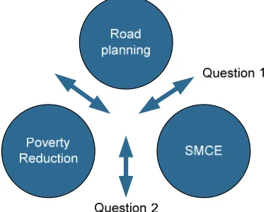
[image:14.595.90.278.337.487.2]The two questions are answered around three main principles. These are the principles of road planning, poverty reduction and SMCE. How the two questions hook into the three principles is showed in the figure below.
Figure 1: Position of the research questions
The figure shows that one link is not covered by the questions. This is the link between road planning and poverty. Since this link is very important for the general understanding of the research topic and for answering the other questions, the link between road planning and poverty reduction will be discussed as well.
The next paragraph discusses the methodology.
2.2
Methodology
GEO-SPATIAL DATA PROCESSING Relations between transport & poverty Transport Poverty Matrix SMCA Network Analisys Suitability Map Optimal transportation route Sensitivity & uncertainty analysis Assess predetermined route Identification of criteria Ranking LITERATURE REVIEW Transport Poverty paper Sustainable Development paper Road Infrastructure paper CASE MONGOLIA Spatial Data Statistical Data Other Data Sources Ranking Identification of spatial aspects Comparison (visually, quantitative, qualitative)
Practices for planning of infrastructure
Start of Research
[image:15.595.71.720.86.353.2]At the start of the methodology, there are two main bodies of input, which are placed in the orange frame. First there are the papers (or other research sources) which describe relations between transport and poverty, sustainable development and road infrastructure. Second there are case-specific data for Mongolia, which consist of spatial data (geological data and land use data), statistical data (e.g. income figures, employment rate, trade figures) and other data sources (e.g. interviews, law or governmental plans).
Based on the papers, current practices for the planning of road infrastructure are identified, in order to give answer to question 1a. and 1b. These outcomes will also serve the SMCE. Furthermore, a list of relations between transport and poverty is formed. This list will serve as input to the Transport Poverty Matrix. This list will also serve to identify the spatial aspects from which a selection will be used in the SMCE. How this selection will look like, depends on the outcome of the Transport Poverty Matrix and the ranking of relations accordingly. Strong relations are likely to receive preference over weak relations. Finally, a selection will be made and transferred into criteria that can be used spatially in the SMCE.
When the SMCE is fed only by poverty transport criteria (which leads to a pure poverty reduction suitability map), certain constraints are looked over. Therefore, other criteria will be developed from the case. These criteria are for instance constraints regarding soil types, slopes and the crossing of environmental protected zones, but also legislative plans. These will also be ranked (weighed) and used as input for the SMCE. The output of the SMCE is a suitability map. This map is divided into a grid with pixels, where each pixel receives a suitability value. Network analysis will then create a route with the highest possible suitability over the network of existing1 roads. The process of the SMCE can be done more time, with other rankings of criteria in order to get different alternatives.
The result is several routes constructed over different weighing of the alternatives. These routes can be compared with a reference route. Comparison can be done in different ways. The first way of comparison is visual. Just by looking at the routes and the differences, assessment can be done. However, much information stays hidden this way. Quantitative comparison is another possibility. Length, impedance and other quantitative characteristics can be compared. The best way of comparison however is a qualitative way in which something can be said about if and to what extent a route contributes to poverty reduction. This will be done using the method of cost-benefit analysis or CBA. Costs and benefits of the proposed alternatives will be expressed in monetary units. This means that costs of poverty and benefits of poverty reduction have to be expressed in money terms as well. Finally, the result of this method gives answer to the question whether or not the SMCE method contributes to poverty reduction.
1
3
Literature review
This chapter discusses literature that has been reviewed for this research. The literature review will be structured according to a funnel-shaped principle and will be based on three main subjects:
1. Planning of road infrastructure and routing
2. Poverty alleviation through road infrastructure provision
3. SMCE as a tool for impact evaluation of poverty reduction road planning
The figure below presents the structure of chapters 3, 4 and 5 graphically.
Figure 3: Structure of chapters 3, 4 and 5
Based on the introduction in the first chapter, the planning of road infrastructure and the routing question is discussed first, as it is unclear what the current principles and methods are (especially for the generation of route alternatives). Once insight is gained on this part, the link to poverty and poverty reduction is made. Many claims have been made on road infrastructure and accessibility contributing to poverty alleviation. However, none of these claims have been subject to impact evaluation, which is necessary in order to be able to make prove the claims. Here is where SMCE can fulfill a role in supporting the research and providing a tool that can help in the process of impact assessment. When impacts can be estimated beforehand with SMCE and measured afterwards with the support of panel data, routes can be designed to such an extent that they can actually contribute to poverty reduction.
methodology followed will be described based on the information derived from chapters 3 and 4.
3.1
Planning of road infrastructure and routing
Current practice in the planning of road infrastructure is discussed in this paragraph. Three topics will be discussed here. These are:
• Transport planning in general
• Planning of highway infrastructure
• Generation and selection of route alternatives
Based on a discussion on these three topics, an overview of the current practice in the planning of infrastructure can be given.
3.1.1
Transport planning in general
According to the definition of the Transport Planning Society in the UK, transport planning is:
"Transport planning is taken to be all those activities involving the analysis and evaluation of past, present and prospective problems associated with the demand for the movement of people, goods and information at a local, national or international level and the identification of solutions in the context of current and future identification of economic, social, environmental, land use and technical developments and in the light of the aspirations and concerns of the society which it serves"
What can be learned from this definition is that transport planning starts with the analysis and the evaluation of problems associated with the demand for movement. Initiation of analysis and evaluation is mostly, if not always, guided by governmental authorities, since these usually bear the responsibility for the infrastructure. Usually, when a problem is identified, public authorities react by developing a transport policy. Transport policy can be defined as:
“Transport policy is the development of a set of constructs and propositions that are established to achieve particular objectives relating to socio-economic development, and the functioning and performance of the transport system”.2
The transport policy process (and policy processes in general) can be visualized by the policy cycle. This policy cycle shows the steps that are taken in the policy process. An example of a policy cycle is shown in Figure 4.
Figure 4: Policy Cycle (as used by ERA-NET TRANSPORT)
The policy process is consisting of 3 phases, the policy formulation, the policy realization and the policy learning. It is a cycle, which means that policy is a continuous process.
The difference between planning and policy is that transport policy has a strong legislative basis. Policies are often, but not always, incorporated into laws and other legal instruments that serve as a framework for developing planning interventions, whereas planning does focus on achieving a particular (meta)goal.
Given the overview of planning in general, the next step is an elaboration on the planning of highway infrastructure.
3.1.2
Planning of highway infrastructure
The planning of transport infrastructure differs for every country. This paragraph will describe the Dutch situation as an example for the planning of highways (network of national roads and express roads). In the Netherlands, planning of highways is done by following a nine step procedure, called corridor / EIA (Tracé / m.e.r.) –procedure. The nine steps in this procedure are:
Step 1 gives an outline of the problem and the direction of solutions the government desires to
Step 1: Start note
Step 2: Participation and advice Step 3: Route note / EIA
Step 4: Participation, advice and check Step 5: Taking position
Step 6: Preliminary route decision Step 7: Route choice
step, this note can be commented and criticized from the general public. These comments will be taken into account in step 3, in which the problem will be described in detail and detailed solutions including their effects will be given. Again, this note will be available for comments from a general audience as well as from specialists. Based on this round of comments, the minister of the Department of Transport will take position, which will be further developed in the preliminary route decision. After this step a final round of participation by the general public takes place before making a final decision. Finally, the construction phase can be started, followed by an evaluation of the environmental aspects. If necessary, measures are taken to restore possible negative impacts on the environment.
In the third step of the process, route alternatives are generated and for each alternative the environmental impacts are given. It is not stated how alternatives are generated and what type of criteria are taken into account. Moreover, already in the first step directions are given where to search for solutions. Possible solutions can therefore already be biased from the first step on.
Recently a new design manual for highways (NOA) was published by the Dutch Directorate General for Public Works and Water Management (NOA, 2007). These guidelines supersede the old guidelines because of criticism to the former on the lack of stakeholder involvement. NOA no longer takes into account only technical criteria but says design should be based on functional design principles. The idea is to go from policy and technical principles towards a design question. This can be seen as a framework to generate solutions and test them according to the design question. The subjects that are discussed in the framework are: Accessibility, Safety, Environment, Infra-providing (maintenance), Traffic Management and Costs. The remaining of the report is used to elaborate on the technical criteria of planning motorways such as curvature, slopes, viewing angles etc. The amount of technical criteria and their nature makes that these criteria might influence the route generation to a very large extent.
Not only the Netherlands have such guidebooks on the planning of motorway infrastructure.
The road planning and design manual of the Queensland Government in Australia (Queensland, 2002) shows as well a high focus on technical criteria with only limited attention to function of roads or stakeholder involvement.
In the location analysis chapter of the Final Design Concept Report of the US60: Florence Junction to Superior, (US60, 1999) the process of location analysis is discussed and the various options are clarified. Again, almost all criteria mentioned are technical by nature, although the introduction starts with mentioning other criteria as well.
Therefore the next paragraph will focus on the question to how the generation and selection is done.
3.1.3
Generation and selection of route alternatives
There is little known about the procedures that are taken for the generation and selection of route alternatives. This paragraph will try to dig deeper into the topic to see whether any formalized rules do exist. If they don’t exist it is interesting to see how the informal process is done in a particular project. Therefore a short interview with a project leader of a Dutch highway project was organized, which will be presented in this paragraph as well.
The Indian Road Congress has published a manual on route location, design, construction and maintenance of rural roads (IRC, 1997). This manual discusses the route selection in short. The paragraph on route selection says:
The points to be kept in mind from appendix 1 are purely technical. Besides a strong focus on technical criteria (a point already seen in the previous paragraph, the latter part of the quote shows that route selection is based on judgment of one single engineer. Although this part does not say anything on route generation, it shows that selection is done based on judgment of an engineer, which makes the selection a fairly subjective process.
Catbagan and Regidor (Catbagan, 2003) describe in a paper the development of a route selection system using three dimensional cost models. In this paper, an outline is given of various ways highway design and route selection is done. They describe a two step procedure on the process of route generation and selection. In step 1, which is the location step, a draft route is proposed. This is followed by step 2, in which detailed alignment is supported by technical drawings. They show a flowchart of a particular highway location and design process, as can be seen in Figure 5.
Figure 5: Highway location and design flowchart (Catbagan, 2003)
Catbagan and Regidor have further mentioned that route selection is basically a refinement of feasible alternatives, after which they mention a number of (almost all) technical criteria on which feasibility is based. On alignment of alternatives they say that a designer can propose a route everywhere between a start and an end node, but aims on choosing a location with lowest construction cost, the right land, traffic and social consequences and respecting technical constraints.
In the book Route Location and Design by Hickerson (Hickerson, 1967), a number of controlling factors for the location and design of line infrastructure (which also includes motorways) is given. The most important are traffic to be accommodated and terrain. Although in flat country a straight line would be the easiest, curves are applied to avoid monotony of driving and to avoid certain places. Mountainous terrain calls for different solutions. The specific part on highway location and design mentions again two main considerations. These are technical criteria and proper traffic research, including traffic census, OD studies and demand forecast.
In (Nederveen, 2007), the process of route generation is also discussed. From a perspective of cutting down on travel time and on construction costs, a straight line is the most effective solution, unless there are technical boundaries, such as mountains. In areas where there is higher stress on land use, more constraints will occur, which makes the straight line not possible and limits the overall options of route generation. Therefore bundling of infrastructure is used more and more to limit the negative (and diffuse) effects of generating new corridors.
• How many varieties of possible routes connecting the pre-set origin and destination were developed and with what level of detail? How did those routes differ from each other?
• Who designed the routes and what were the criteria, constraints or wishes with respect to designing the routes.
• How were the routes assessed? Was the assessment formalized or developed for this project only?
The project that should connect University and A1 started with the local mobility vision in which this project was initiated. While this project has a long time to go until completion, the route generation and selection would go as follows:
First, the start and end point of the connection should be decided upon. This is done by logical reasoning by the project team. The next step is that a project team would design several alternatives, based on expertise and based on the constraints of the area. Such a team would consist in this specific case of traffic specialists, spatial planning specialists, environmental specialists and perhaps some of the larger stakeholders in this project such as University representatives. Based on their expertise, the goals of the project and the constraints set by the environment they will design several alternatives and will assess those alternatives based on criteria they choose. These criteria are usually a mix of qualitative and quantitative criteria. The alternatives will be sent to the cities executive board (college van B&W) who will decide on a preference for a certain alternative. This alternative will be approved or rejected by the city council (gemeenteraad). The process is highly informal as this is usually the case with road that are being planned / constructed under local authority. When roads belong to higher authorities things change.
The N18 belongs to a higher level road authority, which is in this case is the Dutch Directorate General for Public Works and Water Management. Although the planning process is highly formalized in these projects (the earlier discussed Trace / m.e.r procedure) the design and selection of route alternatives is not. Based on 2 main criteria, connecting Twente with Arnhem and increasing safety in the surrounding region, alternatives were developed by the project team. Those alternatives differ from each other in whether they pass villages and on which side. More variants are brought in by stakeholders and finally all variants are assessed using a multi criteria analysis.
Although the route selection process became clear from this interview, the actual design process still remains vague. There is a need for clarification though, for two reasons. First, when a transparent design process is known, evaluation of this process would be easier. Secondly, a comparative study between the current process of designing a corridor and the design of a corridor using SMCE could be done. Then the strong and weak points of each method can be found and recommendations can be done on how to deal with both methods.
3.1.4
Summary
Paragraph 3.1 discussed the concept of planning. Planning in general, planning for highways and the generation and selection of route alternatives is discussed in this paragraph. The outcomes of this paragraph create enough background to start with the concept of poverty.
The outcomes of this paragraph also make it possible to answer the question: What is the current practice in the planning of road infrastructure (in general, and for highways in particular).
The current practice can be summarized as:
• Derived from policy. Policies in which goals are presented are transformed into actual projects which also incorporate the planning of road infrastructure.
• In the Netherlands the process is highly structured with lots of attention to public participation
• There is plenty written on technical criteria or constraints, but hardly anything on other criteria.
• The process of route generation and selection is a vague process, usually taking into account different criteria. The number of criteria (especially the technical criteria) limits the generation and selection of alternatives. This makes the process of route generation and selection unclear.
Finally, a point that should be taken into consideration is that scale is affecting the planning of road infrastructure. How scale can be considered should be taken into account when using SMCE in the planning process. Although this research will not focus on scale, it will give directions on how scale can be applied to further research in the recommendations chapter.
Now that the planning of road infrastructure is discussed, the next step is to see whether planning can have a positive impact on the reduction of poverty. This difficult question will be discussed in the next paragraph.
3.2
Accessibility, Poverty and Infrastructure
This paragraph will start by giving some definitions of poverty, from which the scope of poverty is made clear. Next, the link between poverty and accessibility (and later road infrastructure) will be discussed. A special paragraph on poverty in chapter 4 will elaborate on poverty and poverty alleviation for Asian Highways and for Mongolia.
Poverty in this paragraph will be discussed from two key aspects. These are the multidimensional aspect of poverty and the spatial aspect of poverty. What these aspects actually mean will be clarified in this paragraph as well.
3.2.1
Definitions of poverty & poverty in MDGs
On poverty, numerous definitions exist. The World Bank says the following on poverty:
The World Bank describes poverty using several examples. These examples are based on the basic amenities a person needs: food, shelter, healthcare, education, employment and a voice. This description explains the poverty still existing in many parts of the world, in all its dimensions.
The Asian Development Bank (ADB) gives this definition which is taken from (ADB, 1999):
The definition from the ADB shows similarities with the definition from the World Bank. Both discuss that people are deprivated from needs as food, shelter, health, education etc.
Poverty is also represented in the Millennium Development Goals or MDGs. The MDGs are a set of meta-goals and targets the United Nations has set to accomplish for 2015 for some of the poorest countries on earth. Although very broad and rough they are used by governments and NGO to monitor their policies. In the Millennium Development Goals, the eradication of extreme poverty is represented by 3 targets with in total 9 indicators. Target 1a focuses on
“Poverty is hunger. Poverty is lack of shelter. Poverty is being sick and not being able to see a doctor. Poverty is not having access to school and not knowing how to read. Poverty is not having a job, is fear for the future, living one day at a time. Poverty is losing a child to illness brought about by unclean water. Poverty is powerlessness, lack of representation and freedom.”
monetary poverty, target 1bn employment and target 1c focuses on hunger. An overview of the targets and indicators can be found below.
As can be seen from the targets and indicators, poverty as described by MDG-1 addresses less dimensions as the definitions given by WB and ADB. The most probable reason for this is the fact that many other MDGs are addressing other dimensions of poverty. Education is addressed in MDG-2, health in MDGs 4, 5 and 6, gender equality by MDG-3, Environment by MDG-7 and Global Partnership by MDG-8.
According to Leipziger (Leipziger et al, 2003), many see that the MDGs are representing the key development challenges for governments and international organizations. To some others, the goals 2 to 8 seem to be superfluous as long as no progress on goal 1 (Eradication of extreme hunger and poverty) is made. Tandon (Tandon, 2005) gives empirical evidence that there is a strong relation between economic growth and a decline in child mortality. Though MDG 1 cannot be seen as the most important of goals, it is a key goal with many linkages and correlations to all other MDGs. Food and shelter are among the basis needs of people and only if basis needs are fulfilled, people can work on reaching other needs.
Many more definitions do exist. Almost every NGO or governmental body creates its own definition of poverty that suits the organization best. However, they will all have a few parts in common. They all address the multiple dimensions of poverty. Poverty is not only lack of food or money. It is consisting of many more dimensions. Another part many of these definitions share is the word “access”. People don’t have access to opportunities. And not having access means there is impedance between the people and the opportunities. Although access can be seen in various dimensions one of the most important dimensions is physical access. People physically cannot reach their opportunities (for various reasons) or the opportunities cannot be brought to the people.
Target 1a: Reduce by half the proportion of people living on less than a dollar a day 1.1 Proportion of population below $1 (PPP) per day
1.2 Poverty gap ratio
1.3 Share of poorest quintile in national consumption
Target 1b: Achieve full and productive employment and decent work for all, including women and young people
1.4 Growth rate of GDP per person employed 1.5 Employment-to-population ratio
1.6 Proportion of employed people living below $1 (PPP) per day
1.7 Proportion of own-account and contributing family workers in total employment Target 1c: Reduce by half the proportion of people who suffer from hunger
1.8 Prevalence of underweight children under-five years of age
Hence, 2 components are very important in each definition of poverty, and therefore in each poverty alleviation projects or scheme. Those are:
• Poverty is multidimensional. There are many indicators for poverty and poverty is more than just a lack of food or money. Poverty is multidimensional in the different kinds of poverty, but also in the incidence of poverty. Relative poverty (1 person being poorer or less poor than the other) can be seen as a dimension of poverty as well. If poverty is multidimensional, poverty alleviation should be multidimensional as well. All dimensions should be covered in the ideal poverty alleviation tool.
• Poverty is closely related to having access. Poor people do not have access to assets or opportunities which could make them escape their situation. On of the key access indicators is physical access. This makes poverty a spatial phenomenon as well, since poverty is spatially heterogeneous (Stewart, Kuffer, 2007). The fact that poverty can be seen as spatially heterogeneous is one of the justifications of this research. If there would be no spatial differences in poverty in a certain study area, the idea of adding poverty indicators to a spatial multi criteria analysis would make no sense. This also brings in the idea of relative poverty (differences in poverty or wealth between people on different scales) and geographic poverty traps: areas in which people are more vulnerable to be struck by poverty than in other areas.
The two components mentioned above will be subject throughout this paragraph. It will be visible that multidimensionality and spatiality are also of importance when discussing the link between poverty and transport.
The next part of this paragraph will consist of the discussion between these fields of poverty and transport, which is very extensive.
3.2.2
Studies on Transport & Poverty relations
Ample studies have been published about the linkages between road infrastructure and transport. One of the recurring conclusions in nearly all studies is that better road infrastructure is a necessary condition for poverty reduction, but not a sufficient condition. Transport’s role is a complementary one, as described by Gannon and Liu (Gannon & Liu, 1997). Transport itself cannot feed poor people, cannot give poor people money and cannot give poor people work (unless the poor are directly contributing to road construction). However, transport creates access to food opportunities, access to health, access to education and transport creates access to having money in creating access to employment opportunities.
In order to show the amount of research that has been done, some examples are given below.
1. Road investment & improved access to transport services can be effective in increasing agricultural production. (DFID, 2002) also seen in various other researches
3. Provision of transport infrastructure and services can facilitate (or constrain) poor people’s access to locations where there is greater demand for their services (Blume et al, 1995)
4. Transport is a source of employment (Gallager, 1992)
5. Transport sector creates opportunities for employment through labour based infrastructure construction projects (Ravallion, 1990)
6. Improvement market access through better transport conditions increased surplus
lower production & transport costs (ESCAP, 2006)
7. Stimulates economic growth, raises agricultural and urban productivity, generates surpluses, facilitates diffusion of new technology and spread of new ideas and innovations
Facilitates access to employment and product market
Generates employment
Facilitates growth of secondary and tertiary sectors
Promotes tourism along major transport corridors
Improves food security by increasing food production and distribution through increased efficiency of the supply and marketing chain
(All ESCAP, 2006)
8. Conditions affected by rural road development are
• Changes in transportation services
• Changes in travel patterns
• Changes in village profile
• Changes in income and welfare
In many of the examples, both employment and accessibility are mentioned as the positive impacts of road infrastructure on poverty reduction. Most of the relations mentioned above can be summarized in the concepts of improvement in transport infrastructure which creates an improved accessibility to employment possibilities. This can of course be generalized, saying that an improvement in transport infrastructure creates improved access to all kinds of opportunities, including employment, education, healthcare etc. This is where the multidimensionality and the spatial component come together over some examples from literature. These concepts will be used further in this research to incorporate poverty reduction in SMCE.
The link with the Millennium Development Goals is also evident. When focusing only on poverty (and not on hunger), employment is even set as a separate target.
poverty and transport. However, it will not be done because it is very difficult to choose the right dimension and classify accordingly. Both poverty and transport are too vague as a concept to find one dimension of categorization. Besides, the relations are very clear cut so the need for such a matrix is not very high.
3.2.3
Impact evaluation of Transport & Poverty relations
Funding of road projects by financing organizations is very popular. As can be seen from Figure 6, 20 percent of loans are related to transportation.
Figure 6: World Bank loans per sector
Van de Walle (Van de Walle, 2002 & 2009) states, that despite the popularity of those projects, few of these projects have been subject to a proper impact evaluation. This means that the knowledge on impacts in limited. However, the potential of rural road projects on poverty alleviation is believed to be high, which gives a high need for those impact evaluations. According to van de Walle, “a credible rural roads impact evaluation requires panel (with pre-intervention) data for project and appropriate non project areas; detailed information on outcome indicators, baseline attributes and controls for heterogeneity and exogenous time varying factors. Geo-referenced data can also be extremely useful. With the appropriate data and techniques a large number of interesting and far-reaching questions about rural road impacts can begin to be answered and discussed with large public good benefits.”
Although Van de Walle discusses this for the purpose of doing impact evaluation for rural roads, this needs to be done for every type of road infrastructure that is said or thought to be beneficial for the poor people, including higher classified roads such as highways or motorways.
One of the techniques that could contribute to poverty reduction is the use of SMCE. With the appropriate data and techniques the SMCE tool could function as a pre-assessment tool for the impact evaluation of road projects. What SMCE is and how it could serve a purpose will be discussed in the next paragraph.
3.2.4
Summary
different views on the concept of poverty. Two components are present in almost every definition of poverty. These are multidimensionality and spatiality.
Poverty as a multidimensional phenomenon can be seen in the Millennium Development Goals among other sources. In the MDGs, almost all of the goals can be linked to poverty. Poverty is lack of food or employment (MDG 1), lack of education (MDG 2) or lack of proper basis healthcare (MDGs 4, 5 and 6).
Poverty is also spatial, because there is distance between the poor people and their opportunities, because poverty is spatially heterogeneous and because poverty is relative. In fact, the spatial dimension of poverty is one of the many dimensions poverty has, which makes poverty a difficult topic to work with when not properly defined. The fact that poverty is multi-dimensional and spatial, makes that scale plays a role here as well. In different (geographical) scales (which is a spatial way of looking at poverty), different dimensions of poverty can have a larger or smaller role.
This paragraph also showed that poverty and road infrastructure (both in construction and use) are linked. There are many researched that show the linkages between poverty and transport. Two things are often seen in these linkages. Many road infrastructure projects are said to contribute to poverty reduction over the creation of employment, or creating access to employment. Access and employment are keywords in the link between poverty and transport, and should therefore be taken into special consideration.
Where should access and employment be taken into special consideration? This should be done when developing a tool that could contribute to the impact evaluation of projects where road infrastructure could contribute to poverty reduction. The methodology possible of creating such a tool (SMCE) will be discussed in the next paragraph.
3.3
SMCE & Poverty & Transport
This paragraph will discuss Spatial Multi Criteria Evaluation or SMCE as a tool that can contribute to the impact evaluation of the positive contribution of road infrastructure to poverty reduction. In the previous 2 paragraphs the planning of road infrastructure (in general and for highways) and the concept of poverty (in general and in relation to road infrastructure) are made clear. This paragraph will first explain what SMCE. Then general applications of SMCE will be explained, followed by a discussion on the use of SMCE for line infrastructure (like highways) and the implications this has for the SMCE process. Before an explanation of SMCE is given, an outline of the general process of multi-criteria evaluation (MCE) is given.
3.3.1
MCE and SMCE
weighed sum method. Next, the criteria receive weighs, and the criteria weighs will be multiplied with the standardized scores of the alternatives. This will ultimately lead to a ranking in the alternatives, where the best alternative given the weighs to the criteria will come out. Of course, variation can exist between the weighing of the criteria, which will lead to other ranking in the alternatives.
SMCE stands for Spatial Multi Criteria Evaluation. It is a powerful tool in a GIS environment which helps making spatial decisions using multiple spatial criteria.
SMCE can be used with different themes and different criteria, making a suitable for a large spectrum of spatial projects and making it possible to represent a large number of stakeholder views.
The outcome of an analysis is not only depending on the criteria that are used as input. Large influence also comes from the weight that is given to the different criteria. That this influence is large does also mean that giving weights should be done with care, in order to get proper results and prevent abuse of the tool.
For each of the criteria that are used, a standardization process takes places. With this process, the maps received suitability values. In the example with route alignment close to cities, the closer the distance to the city is, the higher the suitability is. The standardization process tells till where the influence of the city reaches. The suitability value runs from 0 to 1.
The main difference with MCE is the different alternatives are output of the method rather than input. Input maps are scored and standardized on suitability and the weighing of the different criteria (i.e. the standardized scored of the maps) will decide on the output, which can be the suitability of an area or corridor.
In order to explain the process of the SMCE visually, some examples of SMCE are given.
Figure 7: SMCE of potential productivity for grazing (Source: Nicta, Australia)
Figure 8: SMCE of suitability map for Via Baltica.
With these suitability maps, routes are created based on a network analysis with least impedance. The results for the equal vision (The Equal Vision Route) can be found below.
Figure 9: Network analysis for Via Baltica
Now it is clear what the concept of SMCE is about, with applications given for both a landuse and a route generation. However, in order to fully understand what SMCE can do, and to be able to use the full potential of SMCE for the purpose this research aims at, an overview of the use of SMCE is given in order to see where SMCE is used for, and where it could be used for. This overview will be given next.
3.3.2
Use of SMCE
[image:33.595.92.241.378.537.2]Although this is just a short list of the research where SMCE techniques have been applied, it can be seen that the majority of research focuses on environment or a combination in which environment is primarily involved. But in general, the extent of applications is very broad. Furthermore, all the researches are involving complex problems with many stakeholders and often a large area of influence. Two pieces of research in the box above have particular interest. These are the cursive articles by Tae-Ho et al and by Keshkamat et al. These will be discussed in more detail.
Economic
A Generic Spatial Decision-support System for Planning Retail Facilities. (Arentze et al, 1996)
An integrated spatial decision support system (SDSS) for rural development department of Orissa (Ghose. A, 2004)
Construction on Decision Support System for Route Location Based on GIS (Tae-Ho et al, 2008)
Environmental
Spatial decision support for strategic environmental assessment of land use plans. A case study in southern Italy. (Geneletti et al, 2007)
Multi-objective Spatial Decision Support System for Afforestation Management in Mountainous Regions (KU Leuven research theme)
OSS: A Spatial Decision Support System for Optimal Zoning of Marine Protected Areas (Crossman et al, 2007)
A Knowledge-based Geo-Spatial Decision Support System for Drought Assessment (Kozal et al, 2004)
Integrating spatial multi-criteria evaluation and expert knowledge for GIS-based habitat suitability modelling (Store, Kangas, 2001)
Zoning Marine Protected Areas through Spatial Multiple-Criteria Analysis: the Case of the Asinara Island National Marine Reserve of Italy (Ferdinando et al, 2002)
The formulation and evaluation of transport route planning alternatives: a spatial decision support system for the Via Baltica project, Poland (Keshkamat et al, 2008)
Social
Spatial Decision Support System using GIS based infrastructure: Planning in health & education for Ranchi district (Glosh et al, 2002)
Preliminary Design Of A Spatial Decision Support System For Poverty Management (Akinyemi. F.O. 2004)
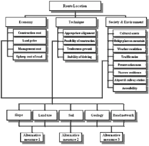
Tae-Ho et al discussed the construction on a decision support system for route location based on GIS. The aim of the study is the application of Analytical Hierarchical Process (AHP) for route location, including a quantitative evaluation. This study takes into account many indicators in various themes. Below, the application map of AHP is presented, which shows the indicators.
Figure 10: Application map of AHP (Tae-Ho et al, 2008)
What can be seen Figure 10is that in the AHP process three main categories are distinguished. These are Economy, Technique and Society & Environment. Under technology, there is another branch with technical criteria for the construction of highways. This gives insight in the possibilities for the construction of criteria for a SMCE process.
The study was able to quantitatively evaluate the appropriateness of established road alignments by applying the AHP based on GIS. Second, the study improved the technique to select road alignments by applying the decision making system.
Keshkamat introduced the combination between SMCE and planning of road infrastructure, and presented a case in Poland. The main findings of this research were that the combination of input of various stakeholders early in the project and via the SMCE can lead to a route that has less negative (environmental) impacts and more benefits. The planning process becomes more structured and transparent. Hence the method can be used to improve Strategic Environmental Assessment (SEA) and Environmental Impact Assessment (EIA).
there is the line infrastructure SMCE research, with more discussed research from Keshkamat and Tae-Ho. The big difference between these two is the effect that choices will have on the environment / surroundings and can be illustrated with two figures.
Area Line infrastructure
Figure 11: areas vs. line infrastructure
What can be seen from these two figures is that when planning for line infrastructure, the influence will be way larger towards the surroundings. More stakeholders need to be taken into account, more geologic or geographic criteria play a role, i.e. more land in terms of km2 is involved. This makes the process more difficult, what makes the planning of road infrastructure (especially the route generation and selection) a process well suited to use SMCE for. Since SMCE works structured, it simplifies the many processes that are involved when planning road infrastructure and selecting routes.
Finally, a third categorization can be made. Different research can be categorized in SMCE used for planning and design, and SMCE used for evaluation and assessment. What can be seen from the list is that most of the research has a focus on planning and design, although some do focus on evaluation and assessment or even both. SMCE thus is capable of contributing to planning and evaluation.
3.3.3
Summary
This paragraph discussed what SMCE is, how it is used currently and how it is and can be used for the planning of road infrastructure. SMCE is a tool which helps to make spatial decisions using multiple criteria. These criteria range from economic and ecologic to social and technical criteria.
3.4
Conclusion
In the last three paragraphs subsequently discussed the topics of road planning, poverty and poverty alleviation and SMCE. In this last paragraph, these topics came together and a conclusion could be formulated on answering the first research question: Can geospatial technologies and SMCE contribute to the planning of road infrastructure as an institutional tool for poverty reduction?
The process of planning road infrastructure is often guided by a legislative framework. When main road are planned in the Netherlands, this planning has to follow the framework of corridor / EIA (Trace/m.e.r), in which many control points for design and public participation are built in. The process of route generation and selection however is very fuzzy, despite the complex environment to deal with when designing and selecting a route. Planning of road infrastructure is guided first and foremost by technical (design) criteria. Scale is very important in the planning of road infrastructure. Depending on the scale at which a project is considered, criteria are different and impacts are different. Scale should be taken into account when designing and selecting route alternatives.
The process of design and selection becomes more difficult when social criteria are taken into account or better, are tried to be taken into account. Many claims have been made on the positive contribution of road infrastructure to poverty reduction, but no impact evaluation has taken place so far. This difficult task starts with defining poverty and poverty reduction. This chapter showed that poverty can be seen from two main viewpoints: multiple dimensions and a spatial nature. Of all claims made where road infrastructure contributes to poverty reduction, employment and accessibility are often mentioned as factors.
SMCE is very versatile as seen from the applications. SMCE can be applied to economic, environmental and social themes; SMCE can be used for areas or for the more complex projects involving line infrastructure and SMCE has been and can be used for both design stages and evaluation stages. The only constraint SMCE has is that it’s input needs to be spatial diverse and spatial data needs to exist.
Since poverty and poverty reduction can be interpreted spatially and ample data resources do exist on poverty reduction (e.g. poverty maps), geospatial techniques but especially SMCE is able