Monographs of the School of Doctoral Studies in Environmental Engineering
DOCTORAL SCHOOL IN CIVIL, ENVIRONMENTAL AND MECHANICAL ENGINEERING
Spatial planning to integrate climate change
adaptation at local level
Parveen Kumar
Doctoral thesis in Environmental Engineering, XXVII Cycle Faculty of Engineering, University of Trento
Academic year 2014/2015
Supervisor: Dr. Davide Geneletti (University of Trento)
University of Trento Trento, Italy
“Only within the moment of time represented by the present century has one species -- man -- acquired significant power to alter the nature of the world.”
II
Acknowledgement
The three years of my PhD has been an incredible and life changing learning experience which has culminated into this piece of research work. Like a journey of a thousand miles it started with a single step; a step towards answering my curiosity, a single question to solve one small problem. I cannot say that this journey was easy, but numerous people have helped me see it through with their support and encouragement. Before you read the details about the destination of this journey in the chapters of the thesis, I will like to recount the details of the journey itself in this acknowledgement with fond memories and heartfelt gratefulness to all those who have accompanied me as my supervisors, research collaborators, family, friends or critiques.
First of all I would like to express my heartfelt and deepest gratitude to my supervisor Dr. Davide Geneletti, who has been a constant source of support, encouragement and who has shown complete faith in me. I thank him for giving me my personal space and freedom to explore different ideas, precise guidance and at the same time key critiques of this work. He helped me find my way around a relatively new area of expertise with patience and I am thankful to him for inspiring me to write this piece academic work.
This research work would not be possible without the help of Professor Kamal Bawa (University of Massachusetts, Boston, USA) and Professor Harini Nagendra (Azim Premji University, Bangalore, India). I sincerely acknowledge Dr. Bawa’s efforts in introducing me to the wonderful research organisation of Ashoka Trust for Research in Ecology and the Environment (ATREE) and hosting me for my fieldwork. His insightful thoughts, suggestions and discussion on environmental issues and concerns in Darjeeling region helped me develop the case study on Eastern Himalaya, Darjeeling District.
This research work was greatly shaped by Dr. Nagendra and her work on Bangalore urban area. I have come to deeply respect and admire her work, engagement in environmental campaigns as well as her work ethics and promptness in reviewing my work. This research work was benefitted by her collaboration and supervision for developing the Bangalore case study. I am also thankful to her for helping me out with data collection, introducing me to key sources and funding some of the data under USAID PEER grant to ATREE.
I also take this opportunity to sincerely acknowledge the Department of civil, environmental and mechanical engineering, University of Trento, for providing the research funding for this Ph.D. research and to the department staff for their daily administrative help.
III
Unnikrishnan from ATREE, Bangalore, India for their tremendous help in conducting the interviews and helping in data collection for Bangalore urban area. Also I would like to thank ATREE, Bangalore staff for making my stay comfortable and helping with field work logistics. I thank Dr. Ganesan Balachander, (Director), Dr. Veena Srinivasan (Fellow), Ameya Gode (Research Associate), Madhvi, Hemalatha G, N. Ramesh from (Staff ) ATREE for administrative and technical help. I expand my thanks to fellow ATREE colleagues Sandeep Sen, Paramesh M, Aniruddha Marathe, Vidyadhar Atkore, Venkat ramanujam, Shweta Basnett, Yangchenla Bhutia, Urbashi Pradhan and many more for their love and support.
I am grateful to Dr Sarala Khaling (Regional Director), Samuel Thomas, Michelle Gurung, Rinchen Angmu, Anand Gazmer, Tenzing Sherpa, Arjun Rai, Prakash Tamang and Rajen Chettri from ATREE, Darjeeling office. Without their help it would not be impossible to find my way around Darjeeling district. I thank them for linking me to the network of local organisations and government official for my research work. I am grateful to the local government organisation District Magistrate office, Darjeeling Gorkha Hill council, West Bengal forest department and Tea Board of India based in Darjeeling and Kurseong. I am deeply grateful to Anugyalaya Darjeeling Diocese Social Service Society specially Arpan Emmanuel Rai, Robert Lepcha, Christofer Lepcha and his family for hosting my stay during my field work. I would also like to thank other organisation likes Save the Hills, Chai, Darjeeling Municipality, FOSEP, West Bengal Regional Planning Department/Siliguri Jalpaiguri Development Authority, District health office, PRERNA for their insightful discussion and observation. I would like to thank Mrs. Hashi Roy, from Census of India, Delhi office, for proving and helping me with the census data.
I am grateful to all the people that I met in Trento during the last three years. I would like to particularly thank our research group: Paolo, Francesco, Elena, Marika, Lidya, Cristina, Carlos, Linda and Blal as well as colleagues from 27 Cycle for their support and invaluable advice. I would also like to acknowledge the Indian community in Trento: Dhaval, Raju, Prashant, Pramod, Kiran, Pradanesh, Tinku, Jinu, Sajid, Meera, Prasanta, Aridam and many more. At the same time also thank our landlord Antonella Righi, Conotter Renzo, Chiara and Nicolo for integrating us into their your family and making us feel at home away from home.
I would also like to thank some of my friends and family from SPA, New Delhi and University of Twente, Netherlands, namely, Chaki (long hours of English editing), Arun, Suru, Ravi, Mota, KKV, Arnab, Namita, Parvesh, Madhushree, Daljeet, Chotu, Yamini, Gaurav, Rishi, Tanmoy, Shukhad and Mitava.
IV
Italy, not knowing where life would take me next. I am grateful to my In-laws Samir, Krishna, Kunal and Sandhya for their support and encouragement and for letting me marry their daughter when I was doing my PhD without knowing what the future hold for me.
Finally I am grateful to my wife Maitreyi for her motivation, patience, constructive criticism and long hours of English and scientific editing. Words are not enough to express my deep emotions and love. This thesis would not be possible without your help. I might be thought behind this work but shape of this work is only possible because of you.
VI
Contents
CONTENTS ... VI LIST OF FIGURES ... X LIST OF TABLES ... XII SUMMARY ... XIV
CHAPTER 1 ... 1
1 INTRODUCTION ... 2
1.1 BACKGROUND ... 2
1.2 ROLE OF SPATIAL PLANNING TO MANAGE CLIMATE CHANGE ISSUES ... 5
1.3 KEY GAPS ... 7
1.3.1 Translation of climate science knowledge to spatial plans at various spatial scales ... 7
1.3.2 Lack of understanding of the core issues ... 8
1.3.3 Lack of tools and methods at various spatial scales ... 8
1.3.4 Policies and decision interplay ... 9
1.4 RESEARCH OBJECTIVES AND UNDERLYING QUESTIONS ... 10
1.5 THESIS OUTLINE ... 10
CHAPTER 2 ... 13
2 HOW IS CLIMATE CHANGE ISSUES INTEGRATED INTO SPATIAL PLANS? ... 14
2.1 INTRODUCTION ... 14
2.2 STUDY CONTEXT ... 15
2.2.1 Emerging patterns of urbanization in India and effects of climate change ... 15
2.2.2 Climate change discourse in India and international standing ... 17
2.2.3 The policy context: Indian planning policy process ... 18
2.3 METHODS ... 19
2.3.1 Developing the review framework ... 19
2.3.2 Scoring spatial plans against the evaluation criteria ... 22
2.3.3 Selection of the sample of spatial plans ... 23
2.3.4 Data analysis ... 24
2.4 RESULTS ... 25
2.4.1 Overall performance of spatial plans ... 25
2.4.2 Performance by components ... 25
2.4.3 Performance by the criterion under each component ... 27
2.4.4 Performance of cities across India ... 30
2.5 DISCUSSION ... 30
CHAPTER 3 ... 35
3 INTRODUCTION TO THE CASE STUDIES ... 36
VII
3.1.1 Introduction ... 36
3.1.2 Geography ... 37
3.1.3 Demography and economy ... 38
3.1.4 Urbanization and Environmental Issues ... 38
3.1.5 Governance and planning in Bangalore ... 39
3.2 SECOND CASE STUDY: DARJEELING DISTRICT PROFILE ... 40
3.2.1 Introduction ... 40
3.2.2 Geography ... 40
3.2.3 Climate ... 41
3.2.4 Demography and economy ... 41
3.2.5 Environmental issues ... 42
3.2.6 Governance ... 43
CHAPTER 4 ... 45
4 SPATIAL ASSESSMENT OF CLIMATE CHANGE VULNERABILITY AT LOCAL LEVEL: AN OVERVIEW OF AN INDIAN CITY, BANGALORE ... 46
4.1 INTRODUCTION ... 46
4.2 STUDY AREA ... 48
4.3 METHOD ... 49
4.3.1 Exposure ... 49
4.3.2 Sensitivity ... 50
4.3.3 Impact ... 52
4.3.4 Adaptive capacity ... 53
4.3.5 Assessing potential vulnerability pattern ... 54
4.3.6 Cluster analysis ... 55
4.4 RESULTS ... 55
4.4.1 Exposure ... 55
4.4.2 Sensitivity ... 57
4.4.3 Impact ... 57
4.4.4 Adaptive capacity ... 59
4.4.5 Overall vulnerability ... 60
4.4.6 Potential vulnerability profiling ... 60
4.5 DISCUSSION ... 64
CHAPTER 5 ... 67
5 SPATIAL VULNERABILITY ASSESSMENT AND PERCEPTION OF PEOPLE TO CLIMATE CHANGE IN DARJEELING HIMALAYA ... 68
5.1 INTRODUCTION ... 68
5.2 DATA AND METHOD ... 70
5.2.1 Study Area ... 70
5.2.2 Method and Data ... 71
5.2.3 Secondary data ... 73
5.2.4 Primary Data ... 74
VIII
5.3.1 Spatial vulnerability pattern of climate change at Block level ... 76
5.3.2 Overall vulnerability pattern of climate change in Darjeeling district ... 79
5.4 SPATIAL VULNERABILITY PATTERN OF CLIMATE CHANGE AT SITE LEVEL FROM PERCEPTION OF PEOPLE ... 82
5.4.2 Perception of people and overall vulnerability at site level ... 84
5.5 DISCUSSION ... 85
CHAPTER 6 ... 91
6 ASSESSING THE EFFECT OF ECOSYSTEM BASED POLICIES FOR ADAPTATION TO CLIMATE CHANGE IN DARJEELING HIMALAYA ... 92
6.1 INTRODUCTION ... 92
6.2 CASE STUDY AND METHOD ... 94
6.2.1 Case Study ... 94
6.2.2 Method ... 95
6.3 RESULTS ... 100
6.3.1 Land use change analysis ... 100
6.3.2 Ecosystem services and scenario analysis ... 101
6.3.3 Socio-economic modelling ... 103
6.4 DISCUSSION ... 108
CHAPTER 7 ... 111
7 SYNTHESIS ... 112
7.1 OBJECTIVE 1 ... 112
7.1.1 Main findings ... 112
7.1.2 Strength and weakness ... 113
7.1.3 Future research ... 114
7.2 OBJECTIVE 2 ... 114
7.2.1 Main findings ... 114
7.2.2 Strengths and weaknesses ... 115
7.3 OBJECTIVE 3 ... 116
7.3.1 Main findings ... 116
7.3.2 Strength and weakness ... 117
7.3.3 Future research ... 117
7.4 POLICY IMPLICATION ... 117
7.5 REQUIRED REFORMS IN ORGANIZATIONAL AND PLANNING PRACTICES ... 118
7.6 CONCLUSION ... 119
BIBLIOGRAPHY ... 121
APPENDIX 1. THE SCORING FRAMEWORK TO ASSESS THE INFORMATION WITHIN THE CRITERIA ... 141
APPENDIX 2. SPATIAL PLANS FROM VARIOUS CITIES IN INDIA ... 147
APPENDIX 3. PERFORMANCE OF SPATIAL PLANS FOR VARIOUS CITIES ACROSS INDIA ... 149
IX
X
List of Figures
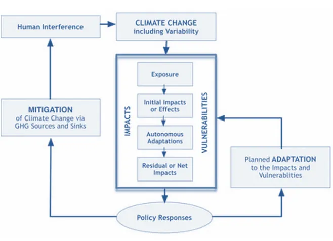
FIGURE 1-1: RELATIONSHIP BETWEEN VULNERABILITY, IMPACTS AND POLICY RESPONSE (IPCC 2001) ... 5
FIGURE 1-2: MAIN STAGES OF CITY BASED CLIMATE CHANGE ADAPTATION. BASED ON (GAGNON-LEBRUN AND AGRAWALA, 2006) ... 9
FIGURE 1-3: INTERRELATIONSHIP OF THE AIM, OBJECTIVES OF THE THESIS WITH POLICIES ... 12
FIGURE 2-1: LEVELS OF URBANIZATION IN INDIA (2011) ... 16
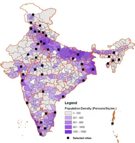
FIGURE 2-2: THE POPULATION DENSITY MAP OF INDIA SHOWING SELECTED CITIES FOR WHICH SPATIAL PLANS WERE EVALUATED. ... 24
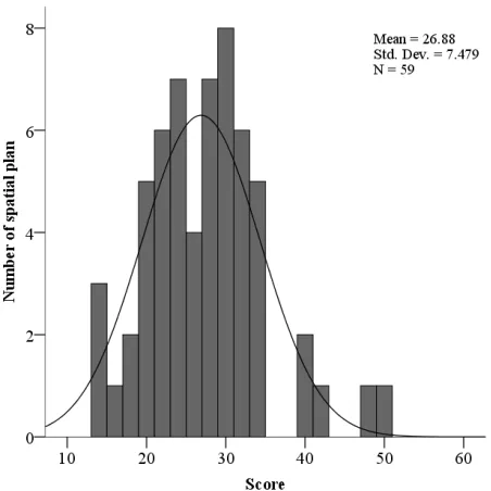
FIGURE 2-3: FREQUENCY DISTRIBUTION OF EVALUATION SCORES FOR INDIVIDUAL SPATIAL PLAN. ... 26
FIGURE 2-4: PERFORMANCE OF SPATIAL PLANS BY COMPONENTS, 3A) AWARENESS COMPONENTS, 3B) ANALYSIS COMPONENT AND 3C) ACTION COMPONENT. ... 26
FIGURE 2-5: CRITERIA PERFORMANCE OF AWARENESS COMPONENT OF SPATIAL PLANS. ... 28
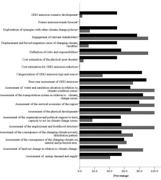
FIGURE 2-6: CRITERIA PERFORMANCE OF ANALYSIS COMPONENT OF SPATIAL PLANS. ... 28
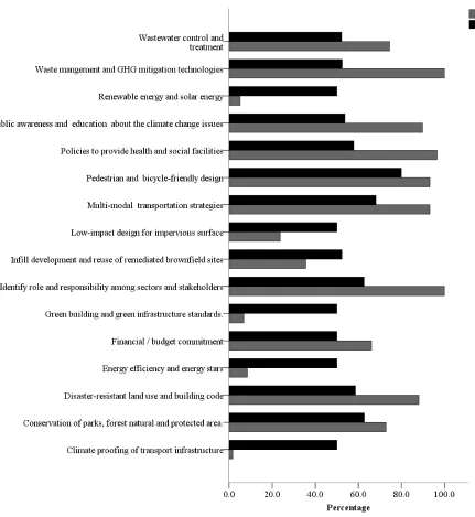
FIGURE 2-7: CRITERIA PERFORMANCE OF ACTION COMPONENT OF SPATIAL PLANS. ... 29
FIGURE 3-1: GROWTH OF BANGALORE FROM 1537 TO 2007 (SOURCE:ADAPTED FROM H.SSUDHIRA AND H.NAGENDRA (2013) ... 37
FIGURE 4-1: THE STUDY AREA BANGALORE METROPOLITAN CITY, INDIA AND LAND COVER MAP 2014, DEVELOPED FROM LANDSAT 8 IMAGE FROM HTTP://LANDSAT.USGS.GOV/ FOR JUNE 2014. ... 48
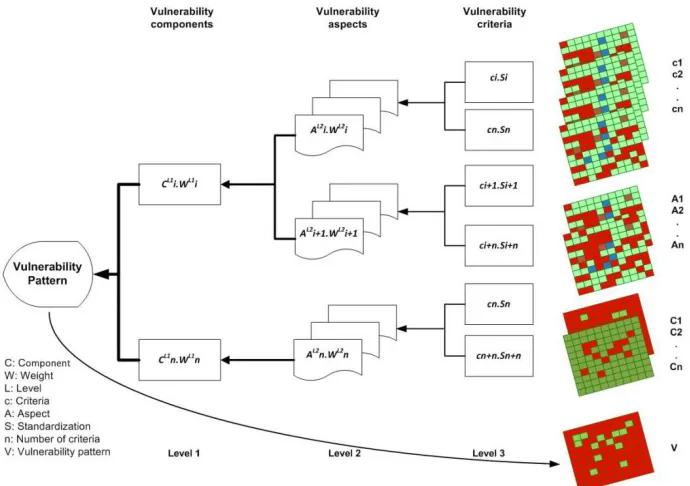
FIGURE 4-2: SCHEMATIC OVERVIEW OF SPATIAL MULTI-CRITERIA EVALUATION (SMCE) FOR CLIMATE CHANGE VULNERABILITY ASSESSMENT ... 54
FIGURE 4-3: SPATIAL DISTRIBUTION OF THE EXPOSURE COMPONENTS OF CLIMATE CHANGE VULNERABILITY AND ASPECTS OF EXPOSURE COMPONENT A)EXPOSURE, A1) NUMBER OF DAYS OF TEMPERATURE ABOVE 30OC, A2) MEAN TEMPERATURE, A3) RAINFALL GREATER THAN 830 MM AND A4) NUMBER OF DAYS ABOVE 30 MM RAIN. . 56
FIGURE 4-4: SPATIAL DISTRIBUTION OF SENSITIVITY COMPONENT OF CLIMATE CHANGE VULNERABILITY AND ASPECTS OF SENSITIVITY COMPONENT B) SENSITIVITY, B1) PHYSICAL AND ECONOMIC ASPECT, B2) SOCIAL ASPECT AND B3) ENVIRONMENTAL ASPECTS. ... 58
FIGURE 4-5: SPATIAL DISTRIBUTION OF CLIMATE CHANGE IMPACTS AND ASPECTS OF IMPACT C) SENSITIVITY, C1) PHYSICAL AND ECONOMIC ASPECT, C2) SOCIAL ASPECT AND C3) ENVIRONMENTAL ASPECT. ... 59
FIGURE 4-6: SPATIAL DISTRIBUTION OF ADAPTIVE CAPACITY COMPONENT CLIMATE CHANGE VULNERABILITY AND ASPECTS OF ADAPTIVE CAPACITY COMPONENT D) ADAPTIVE CAPACITY, D1) SOCIAL ASPECT, D2) BASIC FACILITIES ASPECT AND D3) ECOLOGICAL ASPECT. ... 61
FIGURE 4-7: SPATIAL DISTRIBUTION OF OVERALL VULNERABILITY AND FIGURE 4-8: POTENTIAL VULNERABILITY PROFILES. ... 62
FIGURE 4-9: FRAIMAN MEASURE FOR COMPONENTS OF VULNERABILITY ASSESSMENT (REMARK: THE SMALLER THE VALUE, THE LARGER THE INFLUENCE OF A PARTICULAR COMPONENT IN THE RESULTING OUTPUT) ... 62
FIGURE 4-10: FRAIMAN MEASURE OF ALL THE ASPECTS OF VULNERABILITY ASSESSMENT ... 63
FIGURE 4-11: FRAIMAN MEASURE OF ALL THE INDICATORS OF VULNERABILITY ASSESSMENT ... 63
FIGURE 5-1: THE STUDY AREA DARJEELING DISTRICT, INDIA AND LAND COVER MAP 2014, AND LOCATION OF SELECTED SITE FOR DETAILED ANALYSIS... 71
XI FIGURE 5-3: SPATIAL DISTRIBUTION OF SENSITIVITY COMPONENT OF CLIMATE CHANGE VULNERABILITY AND ASPECTS OF SENSITIVITY COMPONENT B) SENSITIVITY B1) PHYSICAL ASPECT B2) SOCIO-ECONOMIC ASPECT B3)
ENVIRONMENTAL. ... 80
FIGURE 5-4 : SPATIAL DISTRIBUTION OF ADAPTIVE CAPACITY COMPONENT CLIMATE CHANGE VULNERABILITY AND ASPECTS OF ADAPTIVE CAPACITY COMPONENT C) ADAPTIVE CAPACITY C1) BASIC FACILITIES ASPECT C2) ECONOMIC ASPECT AND C3) SOCIAL ASPECT. ... 81
FIGURE 5-5: SPATIAL DISTRIBUTION OF VULNERABILITY PATTERN TO CLIMATE CHANGE IN DARJEELING DISTRICT ... 82
FIGURE 5-6: SITE WISE EXPOSURE COMPONENT ASSESSMENT AND PERCEPTION OF LOCAL PEOPLE ON KEY SENSITIVITY INDICATORS ... 83
FIGURE 5-7: SITE WISE SENSITIVITY COMPONENT ASSESSMENT AND PERCEPTION OF LOCAL PEOPLE ON KEY SENSITIVITY INDICATORS ... 84
FIGURE 5-8: SITE WISE ADAPTIVE CAPACITY COMPONENT ASSESSMENT AND PERCEPTION OF LOCAL PEOPLE ON KEY ADAPTIVE CAPACITY INDICATORS ... 85
FIGURE 5-9: SITE WISE SPATIAL VULNERABILITY PATTERN TO CLIMATE CHANGE AMONG COMMUNITIES IN DARJEELING DISTRICT ... 86
FIGURE 5-10: SITE WISE VULNERABILITY ASSESSMENT BY LOCAL PEOPLE PERCEPTION ... 86
FIGURE 6-1: THE STUDY AREA GHIS AND LEIS WATERSHEDS, DARJEELING DISTRICT AND LAND COVER MAP 2014. ... 95
FIGURE 6-2: LAND USE FOR 2001, 2014, 2030 ... 101
FIGURE 6-3: RESULTS OF ECOSYSTEM SERVICES FOR FOOD PRODUCTION FOR CURRENT AND FUTURE LAND USE SCENARIOS. ... 104
FIGURE 6-4: RESULTS OF ECOSYSTEM SERVICES FOR TIMBER PRODUCTION FOR CURRENT AND FUTURE LAND USE SCENARIOS. ... 104
FIGURE 6-5: RESULTS OF ECOSYSTEM SERVICES FOR CARBON SEQUESTRATION FOR CURRENT AND FUTURE LAND USE SCENARIOS. ... 104
FIGURE 6-6: RESULTS OF ECOSYSTEM SERVICES FOR SOIL RETENTION FOR CURRENT AND FUTURE LAND USE SCENARIOS. ... 104
FIGURE 6-7: RESULTS OF ECOSYSTEM SERVICES FOR WATER YIELD FOR CURRENT AND FUTURE LAND USE SCENARIOS. ... 105
FIGURE 6-8: DESCRIPTIVE COMPARISON AMONG VILLAGES A) SOCIAL GROUP, B) YEARLY HOUSEHOLD INCOME AND C) FOOD SECURITY. ... 105
FIGURE 6-9: CLIMATE CHANGE IMPACTS ACCORDING TO INFORMANT FROM VARIOUS VILLAGES, A) DIRECT IMPACTS AND B) INDIRECT IMPACTS. ... 105
XII
List of Tables
TABLE 2-1: TRENDS IN URBANIZATION IN INDIA (1961-2011) ... 15
TABLE 2-2: THE REVIEW FRAMEWORK DEVELOPED FOR THIS STUDY. ... 21
TABLE 2-3: DESCRIPTIVE STATISTICS OF OVERALL PERFORMANCE AND VARIOUS COMPONENTS ACROSS ALL SPATIAL PLANS. ... 27
TABLE 2-4: CORRELATION MATRIX FOR THE THREE COMPONENTS OF CLIMATE CHANGE ISSUE. ... 27
TABLE 3-1: CHANGES IN NUMBER OF WATER BODIES DURING 1973 TO 2007 ... 38
TABLE 3-2: DARJEELING DISTRICT GENERAL INFORMATION. ... 40
TABLE 3-3: CLIMATE CHANGE CONCERNS IN DARJEELING DISTRICT ... 42
TABLE 4-1: INDICATORS USED TO MEASURE THE EXPOSURE COMPONENT. ... 49
TABLE 4-2: INDICATORS USED TO MEASURE THE SENSITIVITY COMPONENT. ... 50
TABLE 4-3: INDICATORS USED TO MEASURE THE ADAPTIVE CAPACITY COMPONENT. ... 52
TABLE 5-1: SOCIO-DEMOGRAPHIC PROfiLE OF SELECTED SITES IN THE STUDY AREA ... 72
TABLE 5-2: INDICATORS USED TO MEASURE CLIMATE CHANGE VULNERABILITY. ... 75
TABLE 6-1: POTENTIAL ECOSYSTEM SERVICES IDENTIFIED IN THE STUDY AREA AND THOSE ANALYSED ARE IN BOLD .. 97
TABLE 6-2: SOCIO-DEMOGRAPHIC PROfiLE OF THE VILLAGES IN THE STUDY AREA ... 100
TABLE 6-3: LIVELIHOOD SOURCE AND AGRICULTURE ASSET... 106
XIV
Summary
Climate change is directly or indirectly affecting cities, regions or even nations in multiple ways. Impacts are exponential and repetitive with increased instability of climate pattern, socio-ecological systems, increased inequalities and distribution of resources. It is therefore necessary that social and economic hubs and potential resource rich region should become the catalyst that encourages the focus on climate change policies. Despite having various international and national climate change frameworks and forums it is unclear how international, national and even local governments develop response actions to climate concerns and integrate them into different spatial scales. Developing and mainstreaming effective response actions to climate change into numerous sectors, cross-sectoral policies is a complex issue which has plagued policy makers at different spatial scales and on different policy arenas.
In order to efficiently integrate and sensitizing society towards climate change issues, decision makers and different stakeholders have to develop insightful information bases, share awareness of climate change risks, vulnerability patterns and finally develop response actions at all level of policy preparation through policy integration, implementation or structural reforms.
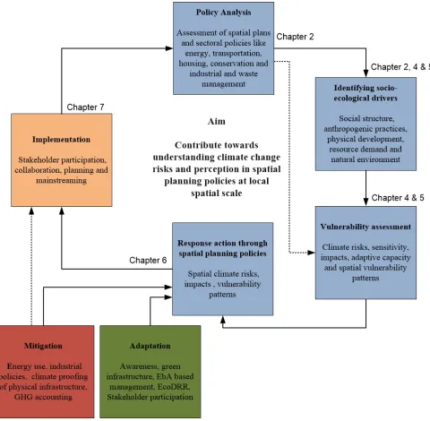
This study contributes towards understanding climate change risks and perception within spatial planning policies at local level. This has been undertaken by investigating, testing or developing real spatial planning policies, vulnerability assessment frameworks and decision support systems that aim to improve current spatial planning tools intended at building climate resilient living spaces. This study was divided into three main stages 1) To develop and test an assessment framework to track integration of climate change issues into spatial planning, 2) To identify hot spots of climate change at urban/regional levels by applying spatial vulnerability assessment tools and 3) To apply eco-system based adaption responses to climate change in an urban region and identifying barriers.
XV
understand how it can increase adaptive capacity and address climate changes issues.
The results of this study identified key concerns to climate change issues and its integration in India. The policy analysis shows that the role of spatial plans to integrate climate change issues at local levels like urban areas and regions in India are still limited. Local policies and spatial plans shows low level of awareness, moderate level of analytical capability and limited action responses to integrate climate change issues at local level. Spatial policies in India are still limited to physical and economic issues and undermine the issues of climate change. The application of vulnerability assessment framework demonstrated that it successfully provided a spatial assessment of climate change vulnerability patterns. The spatial pattern of vulnerability identifies areas requiring urgent attention to adaptation action, enabling policy intervention and prioritizing action. At the same time an analysis of the perception of people also confirmed the results of vulnerability assessment at local level. Finally the results showed how ecosystem services based response actions when applied within spatial planning can play an important role to mitigate the effects of climate change and adapt to local climate concerns with least negative repercussions.
1
Chapter 1
2
1
Introduction
1.1 Background
It is predicted that cities will account for 60% of the world population by 2030 and increase by 70% by 2050 (UN habitat, 2015). As the world population is transitioning from rural to urban regions, these areas are becoming hubs of human induced changes fuelled by development and in turn affecting the environment around it. With fast paced urbanization as well as aging and inadequate infrastructure, cities are likely to struggle in the coming decade to cope with the stress of water, sewage, transportation and other basic infrastructure. This will be further exasperated by the changing climate and exposure to extreme climate events such as hurricanes, typhoons, droughts and floods. Climate change is and will continue to critically impact the socio-economic fabric of the urban system (Rosenzweig et al., 2011). A range of impacts will be observed in the form of increased urban system instability, declines in socio-economic productivity and increased inequities and distribution of resources. It is therefore necessary that urban areas become centre of climate change policies rather than just national scale initiatives. The discourse on climate change initiatives at urban level is only recently gaining momentum. Year 2014 was a landmark in these initiatives with mayors from 40 cities pledging to fight climate change by committing to reduce GHG emissions and account for their progress annually. The key partners of this global compact were C40 Cities Climate Leadership Group (C40), ICLEI – Local Governments for Sustainability (ICLEI) and the United Cities and Local Governments (UCLG) and additionally supported by the UN-Habitat. This initiative is expected to help policy makers in cities and financial institutions that aid in infrastructural development to improve their understanding on the potential impacts of climate change at city level, where support can offered and funding directed. With the global community acknowledging the importance of climate change initiatives at city level, it is becoming apparent that urban areas, small or big, could be one of the key catalysts to engage in mitigation actions to climate change as well implementation of adaptation measures.
3
geography of the urban areas determines its proximity to specific eco-zones and the issues inherently appended to it. For example, historically a large number of cities have been developed close to lakes, river and seas where the problem of flooding is becoming a frequent issue due to impermeable surfaces, lack of green spaces for absorption and ominous drainage conditions. In addition to these two factors, people in developing nations facing poverty, disparity, health risks and political and economic instability are more severely impacted by climate change (Baker et al., 2012a; Satterthwaite, 2007). For example, slums in big cities are high-risk sites , improper housing on floodplains or steep slopes will be the first to be affected during floods, landslide and other extreme weather conditions (Revi, 2008; Satterthwaite, 2007). Changes in climate variables not only affects physical assets of people or urban area but also affects livelihood, capacity stock to local institution and social network of urban systems (Habitat, 2011a). All these factors result on a low baseline resilience of urban systems to climate change and show that urban regions are the spatial regions where vulnerability are most visible and apparent (Field et al., 2014; Habitat, 2011a; Satterthwaite, 2007). Altogether, these critical issues of climate change in the urban system pose the question on how to develop effectively or integrate climate change adaptation response actions within local policies of urban regions.
The early impacts of climate change focused on ecosystems and agriculture and scientist all but ignored the effects on cities which were thought to be inherently adaptable (Comment, Nature 2010). It is only in the past decade that various organizations, government bodies and scientists have begun to assess the first and second order impacts of climate change at city level to develop complex models at small scales that can factor in the urban stressors such as heat islands, air pollution and urban design (Rosenzweig et al., 2011). Even then, majority of studies and assessment reports on the emerging effects of climate change have been climate science-driven (Preston et al., 2011; Rannow et al., 2010). There has been an urgency to act on the scientific assessments of climate change on cities and integrate the know how into policy making (Field et al., 2014). This is easier said than done, given the lack of consensus on methods and financial or human resource disparity among different nations, making climate change a difficult entity to integrate into policies (Satterthwaite, 2007). For example many fast growing developing countries in Asia, Africa and South America are facing severe impacts of climate change but lack the necessary financial and natural resources to act on climate change issues (Field et al., 2014; Habitat, 2011a; Revi, 2008). On the other hand, majority of developed countries of the world although being the key green house gas emitter stress that the developing countries need to take actions without giving them the financial support necessary to undertake such initiatives (Corfee-Morlot et al., 2009; Habitat, 2011a; Urwin and Jordan, 2008).
4
Field et al., 2014; Urwin and Jordan, 2008). Today most international research organizations are investigating and developing frameworks to integrate climate change at all levels of policy processes that will support mitigation, adaption and sustainable development (Lim et al., 2005). Climate change issues have started emerging in mainstream focus areas in general policy making process across the world (Brooks et al., 2009; Field, 2012) and a number of authors have addressed how climate change can be integrated into the planning process (Lim et al., 2005; Urwin and Jordan, 2008; Wilson and Piper, 2010; Yohe and Tol, 2002).
In order to effectively integrate and sensitizing society towards climate change issues, decision makers have to share awareness, recognize changing climatic variable and possible impacts on socio-ecological system of the region (Snover et al., 2007). To integrate climate changes issues into policies at various spatial scales and preparing the society to plan for the possible impacts of climate change, policy makers and decision maker need to recognize key concerns, viz. awareness of climate change drivers and impacts, analysis of effects in the form risk and vulnerability and finally response action at all level of policy preparation through policy integration, implementation or structural reforms at local level (Baker et al., 2012a; Moser and Luers, 2008). These three components are defined as follows:
Components to integrate climate change into spatial policies
Awareness Comprehensive awareness of the key drivers of changing climate variables and its consequences in needed in order to make an informed decision (Lindseth, 2004).
Analysis Involves assessment of risk, impacts at various spatial scales by integrating, quantifying, and synthesizing available information (Füssel and Klein, 2006; Snover et al., 2007).
Action Attempts to use analysis to develop target policies and plans to address locally identified climate change risks and steps that the local government plan to employ to reduce climate change vulnerability (Biesbroek et al., 2010; Biesbroek et al., 2009; Tompkins et al., 2010).
Definitions: Climate change impacts and responses
Climate change Impacts The effects of climate change on natural and human systems
Potential impacts All impacts that may occur given a projected change in climate, without considering adaptation
Residual impacts The impacts of climate change that remain after adaptation measures have been taken
Mitigation Intervention (by government, institutions, companies etc.) to reduce emissions of greenhouse gases to the atmosphere; it includes strategies to reduce greenhouse gas sources and emissions and enhancing greenhouse gas sinks (It is also referred to as reducing the anthropogenic forcing of the climate system)
5 autonomous and planned adaptation
Vulnerability Vulnerability is the degree to which a system is susceptible to, and unable to cope with, adverse effects of climate change, including climate variability and extremes. Vulnerability is a function of the character, magnitude, and rate of climate change and variation to which a system is exposed, its sensitivity, and its adaptive capacity.
Source: IPCC, 2007c: Appendix- Glossary
Figure 1-1: Relationship between vulnerability, impacts and policy response (IPCC 2001)
1.2 Role of spatial planning to manage climate change issues
6 seen as potential policy instrument. Indeed, many of the principles that had begun to creep into land use and transport planning during the 1990s was limited to reduction of emissions of greenhouse gases (Kumar and Geneletti, 2015).
The potential scope of spatial planning to combat climate change is huge because it is not just an environmental problem but deals with a myriad of issues spanning distribution and access to all shared resources such as water, atmosphere, land and energy. Therefore, different authors and researchers have been debating on the most effective ways in achieving sustainable development and address the problems of climate change. For example, the IPCC insists that the effectual way to combat climate change is by influencing land use regulations, infrastructure planning and managing building plans (IPCC 2007). The Stern report on the other hand argues that the real operational measures should include taxation, trading, carbon pricing and technology innovation (Stern 2007. In contrast the European union’s White Papers on adapting climate change has a more holistic view articulated as “A more strategic and long term approach to spatial planning will be necessary, both on land and on the marine areas, including transport, regional development, industry, tourism and energy policies” (CEC, 2009a).
At national level some countries like the United Kingdom, Netherlands and Canada have placed emphasis on the role of spatial planning in delivering emission reduction, increasing adaptive capacity and decreasing vulnerability to various climate change events (Wilson and Piper, 2010). For example, the UK Climate Change Programme, Integration of water board and spatial planning in Netherlands and Canadian Municipalities has placed emphasis on the role of integrating spatial planning and environment issues into strategic planning documents or development control decisions. Some individual local governments across the UK like Leicester, Newcastle and Kirklees, are also developing climate change strategies to integrate climate change concern into land-use planning policies and decisions (Bruff and Wood, 2000; Wilson and Piper, 2010).
7 have advance mitigation impact on climate change issues (Wilson and Piper, 2010). Policy makers, regulators political constituents and stakeholders at different spatial scale require clear understanding and decision support tools that illustrate climate change drivers, concern and impacts so they can make sound, locally relevant climate change strategies in form of mitigation or adaptation action response (Tompkins et al., 2010; Urwin and Jordan, 2008). Currently wide range of tools exists, a few of which have the capacity to work simultaneously at both the regional and local scale, or to capture the multiple consequences of regulatory decisions (Condon et al., 2009). However, they lack the ability to model real-time information and policy process implications. The integration of climate change issues into spatial planning requires an in depth research at not only a theoretical level, but also a practical level dependent on geography and spatial scale.
1.3 Key gaps
Developing effective climate change policies and mainstreaming them into various sectoral, cross-sectoral policies is a complex issue (Biesbroek et al., 2009). Having said that local level spatial systems have the potential role to act effectively on climate change issues in a number of ways (Biesbroek et al., 2009; Hurlimann and March, 2012). At local-level spatial plans are the basic policy framework that shapes social, economic and physical development of cities and at the same time interaction of these aspects become the main drivers of climate change issues at various scales (Wilson and Piper, 2010). Hence spatial planning has a bigger role to play at the local level to climate change issues as it specifies the interrelations and the effects of policy measures on spatial development and it can possibly act as an effective instrument for climate change adaptation response at local level (Wilson, 2006; Wilson and Piper, 2010). However recognising the spatial context and focus of this study there are a number of key challenges to formulating and integrate climate change adaptation solutions at local level. We are highlighting a few of these key challenges in a developing nation like India.
1.3.1 Translation of climate science knowledge to spatial plans at various spatial scales
8 focused on generating integrated solutions that cover all issues addressed by spatial development (Pyke et al., 2007; Rosenzweig et al., 2011). Hence, there is a need for communication between scientists and decision-making that bridges the gap to formulate knowledge based decision support systems for developing climate change action at local level (Pyke et al., 2007).
1.3.2 Lack of understanding of the core issues
Global warming and climate change has become one of the main issues of discussion in the past decade among climate scientist and policy maker based on scientific evidence. While earlier climate change concerns were perceived as environmental problems, it is now being considered to influence the welfare of people based on scientific evidence. Therefore, IPCC and other key climate policy focus organisations are trying to educate the society, local and national governments about climate change issues and its impacts. While researcher are exploring the cross-sectoral interactions of climate change issue to understand its complexity, they are also working on gathering the scientific know how of the effects of climate change between different stakeholders of the society to build resilient and sustainable cities (Biesbroek et al., 2009). Even today, new learning and concerns are brought by different stakeholder involved to reframe the role of society in climate change (Haas, 2004; Jasanoff, 2004).
1.3.3 Lack of tools and methods at various spatial scales
According to the Intergovernmental Panel on Climate Change (IPCC) fourth assessment report (Field, 2012; Field et al., 2014), urgent action needs to be taken on climate change through various adaptation responses along with mitigation strategies in our policy making process at all levels of spatial scale. This is especially true at local levels, because such initiatives and policy implementations need a bottom up approach. However, such response action is not an easy undertaking because developing climate change response action at local level requires in-depth knowledge of climate change vulnerability and its patterns. Unfortunately, not all nations and local governments across the world have sufficient knowledge, awareness, analysis capability and conducive environment to work on climate change issues at the same level, specially in developing nations (Preston et al., 2011).
9
(Hofmann et al., 2011). In addition, vulnerability assessment methods defined for higher spatial scales are difficult to implement at local levels (Holsten and Kropp, 2012; Kumar et al., 2013; Rannow et al., 2010). This is evident from the fact that the few comprehensive vulnerability assessment studies at regional spatial scales are very general and at the same time demonstrate the difficulty in translating output and knowledge into policies given that they do not define degree and magnitude of the results (Füssel and Klein, 2006; Laukkonen et al., 2009; Tol and Yohe, 2007). The absence of a standardised vulnerability assessment framework, to identify extent and magnitude of impacts of climate change for the decision support system for planning policy at local level, is crucial.
1.3.4 Policies and decision interplay
Including different perspective and developing collective conviction to integrate and formulate adaptation response action is the key challenge to spatial planning practices. Planning is exercised within and through government, and is subject to influence from various stakeholders, and it become a matter of trade-off, (Forester, 1999; Hurlimann and March, 2012). Planning decision relies on a range of actors, spatial context, market and collective choice. Wrong choices and decisions lead to policy failures at multiple scales and face severe repercussion (Hurlimann and March, 2012). Even having sufficient information, decision are based on politics and market interests (Roaf et al., 2009), institutional path dependency (Bulkeley et al., 2009), convenience of decisions (Howard and Monbiot, 2009), functional responsibilities and capacity through which climate change concepts can be transferred from policy principles into practice (Bulkeley, 2006; Wilson and Piper, 2010). Addressing these barriers will be critical for planning if it is to effectively facilitate adaptation actions to climate change at local level.
10
1.4 Research objectives and underlying questions
The aim of this study is to contribute towards understanding climate change risks and perceptions in spatial planning policies at local level. By investigating spatial planning policies, an assessment framework and decision support system will be built that aims to improve current spatial planning practices and planning tools intended at building resilient living spaces. The main research objectives of this study and the underlying research questions are as follows:
Objective 1 Objective 2 Objective 3 To develop and test an
assessment framework to track integration of climate change issues into spatial planning.
To identify hot spots of climate change at urban/regional levels by applying spatial vulnerability assessment tools.
To apply eco-system based adaption responses to climate change in an urban region and identifying barriers.
• How is the knowledge of climate science transferred into spatial planning policies at local level?
• To what extents are spatial plans and policies are appropriate policy tools to integrate climate change action at local spatial scales? • What are the key gaps and
shortcomings to address climate change issues by spatial plans?
• What is the basis for the assessment of vulnerabilities and risks from climate change and its usability at different spatial scales?
• How to assess vulnerability patterns, and generate maps of spatial vulnerability to aid in prioritising response actions for spatial planning policies at the urban/regional scale? • How spatial vulnerability pattern and
assessment of climate change differs from the perception of people, social context and institutional arrangements?
• How to understand the relationship between ecosystem services and local climatic vulnerability by investigating the effect of composition and configuration of local ecosystem services?
• What are the ecosystem-based adaptation response to climate change in selected case study in India and its acceptability to the community
1.5 Thesis outline
11 main aim, objectives of the thesis with chapters is also illustrated in Figure 1-3.
The title of the chapters is as follows:
Chapter 1: Introduction
Chapter 2: How are climate change concerns addressed by spatial plans? Chapter 3: Introduction to the case studies
Chapter 4: Spatial assessment of climate change vulnerability at the city scale: an overview of Indian city Bangalore
Chapter 5: Spatial assessment and perception of people to climate change in Darjeeling Himalaya Chapter 6: Assessing importance of ecosystem based policies for adaptation to climate change in Darjeeling Himalaya
12
13
Chapter 2
14
2
How is climate change issues integrated into spatial plans?
2.1 Introduction
Addressing climate change issues requires different response actions at various spatial scales (Preston et al., 2011; Neil Adger et al., 2005). So far these responses have been in the form of international agreements, policy instruments, mitigation and adaptation policies focused especially on the global and national scale (Field et al., 2012; Parry, 2007). However, it has been observed the majority of policies and action response developed at global and national scale are unfit to act on climate change issues driven and experienced at local scale (Measham, 2011 ; Neil Adger, 2005 ). Climate change is a global concern but the drivers and effects are felt at regional and local scales. The goals pursued at the higher scales often clash with the problem faced at local scale (Rannow, 2010; Urwin, 2008). Therefore the issues of climate change should also be analysed and addressed at the local level.
A few studies from the United Kingdom and European Union show that developing effective response actions for climate change at local level may be beyond the capacity of local governments (Wilson, 2006). These observations emphasize the fact that there is a lack of awareness and knowledge on addressing climate change issues at the local scale (Moser, 2008; Neil Adger, 2005), information gap and technical expertise (Wilson, 2006), low level of political support and financial resources (Urwin, 2008; Moser, 2008) and significant disagreement among various stakeholders on climate change issues (Hulme, 2009). According to Wilson (2006) to incorporate climate change response actions at local level, development authorities require detailed information about climate change issues, climate change vulnerability, financial resources, technical expertise and political as well as public participation.
15
ecosystem, biodiversity and other natural resources. Thus local-level spatial plans are the basic policy framework that shapes social, economic and physical development of cities and at the same time interaction of these aspects become the main drivers of climate change issues at various scales (Wilson and Piper, 2010).
Hence spatial planning has a bigger role to play at the local level to climate change issues as it effects of policy measures on spatial development and it possibly has the potential to act as an effective instrument for climate change adaptation response at local level (Wilson, 2006; Wilson and Piper, 2010).
The goal of this paper is to critically review the incorporation of climate change issues in spatial plans across cities in India, and identify significant gaps and shortcomings. This study can potentially aid local governments to identify key areas where innovative response actions are required to foster a better planning practice in the future.
2.2 Study context
2.2.1 Emerging patterns of urbanization in India and effects of climate change
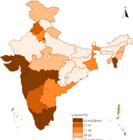
India is among the fastest growing economies of the world and has a target of 9 to 10% growth is GDP. The Planning commission 2008 categorically stated that this rate of growth depended on a vibrant urban sector which contributed to as much as 62% of the GDP. The current Five Year Plan (2012-2017) therefore considers this urban transition as a significant challenge requiring massive growth in infrastructural and services (Bhagat, 2011). In terms of demographics, urban growth refers to the increase in the percentage of population living in the urban areas. There has been a steady increase in the population in urban areas in different states in India (Table 2-1 and Figure 2-1).
Table 2-1: Trends in Urbanization in India (1961-2011)
Census Year Urban Population (in millions) Percentage Urban 1961
1971 1981 1991 2001 2011
78.94 109.11 159.46 217.18 286.12 377.10
16
Figure 2-1: Levels of Urbanization in India (2011)
17
Risks in Indian cities due to climate change induced vulnerabilities
• Loss of Livelihood due to disruption of work, displacement and health reasons. Indirect losses include loss of financial assets, land rights, house or household rights and inadequate identification for rural migrants • Disruption of community safety and support due to displacement and forced migration
• Less resilient population to potential climate distress due to repeated risk exposure, negative net income and loss of assets
• Low access to public services in overpopulated urban areas or urban hinterlands leading to high expenditure for basic needs such as water, electricity and health
• Greater vulnerability due to unsound debt system, economic inequality, political patronage and organized crime which might increase in times of crisis.
Source: Adapted from Mukhopadhyay and Revi, 2009
2.2.2 Climate change discourse in India and international standing
India is the third largest emitter of Green House gases in the world and it is predicted that its emission will increase by 3.4 % per year and India will account for 10% of CO2 emission by 2035
18
2.2.3 The policy context: Indian planning policy process
The Central, State and Local governments are responsible for preparing and implementing various policies pertaining to poverty reduction, population control, providing and improving socio- economic facilities and environmental protection across India. In India, the Central Government lays down policies and priorities of development work with the help of the Planning Commission (Policy preparation institution of the Government of India) and allocates central funds to states for various developmental activities (Commission, 2008, 2011). Then the State and Local government prepare development plans for various developmental activities under the purview of 73rd and 74th Amendments of the Indian Constitution (Ansari, 2004). There are two types of plans that are prepared by local governments: spatial plans and city development plans. In India, spatial plans are referred to comprehensive, cross-sectoral, co-ordinating spatially oriented planning in the public sector. These are long-term policy plans (20-25 years) focussing on spatial-economic development for settlements and cities and it optimise the spatial distribution of land uses. Whereas the City development plans are short-term plan (7 years) aimed at encouraging reforms for fast track planned development of urban infrastructure, service delivery mechanisms and community participation in the cities. Policy documents differ in terms of content and approach. Spatial plans have a legal support and guides development of cities through regulatory framework such as bylaws and standards for various activities. City development plans on the other hand are seen as a priority action plans for various infrastructure activities and instrument to finance these activities.
19
India. In the current state of social-ecological interaction due to internal and external forces becoming complex, challenges for the current spatial planning are addressing issues like multiple deprivation, sustainability, resource distribution and climate change etc.
2.3 Methods
2.3.1 Developing the review framework
Several authors have addressed the question of how climate change can be integrated into the various policy agendas by proposing different frameworks (Brooks et al., 2011; Lim et al., 2005; UNISDR, 2012; Urwin and Jordan, 2008). These frameworks have been widely used at different spatial scales by various international and national research organizations. Most of these assessment frameworks are outcome or sector oriented (Tang et al., 2010), and are used to understand the key gaps and issues related to the climate concerns into policies (Preston et al., 2011; Urwin and Jordan, 2008; Wilson, 2006). The experiences of these frameworks were adapted and used as a reference to develop the review framework for this study, which focuses on the process and potential outcome of spatial plans in future.
20
Based on previous studies on climate change, we identified the main issues that should be represented in spatial plans and correlated them to the ones already mentioned in the pilot study (Baker, 2012; Brooks, 2011; Wilson, 2010; Adger, 2007; Füssel, 2007). The final selection of criteria from the literature and initial analysis of the spatial plans aided in adapting the review framework.
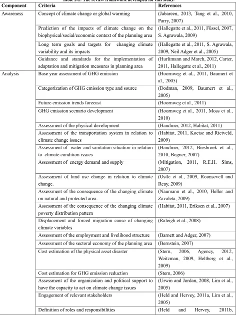
Identification of significant criteria in each component was a crucial step for this study to measure the ability of local authorities to address and plan for climate change issues. The majority of research study on climate change action response used multiple and complex variables to identify the impacts of climate change at various spatial scales (Neil Adger et al., 2005; Stern, 2006; UNISDR, 2012; Wilson and Piper, 2010). The criteria selected for this study from various climate change literature influence the geographic, political, social and economic settings of the region and are usually affected by many internal and external factors like decision-makers’ values and experiences, information base, participation, technical exposure and awareness of alternatives. Forty criteria were identified for this study depending upon the spatial scale and relevance. 4, 15 and 21 criteria were selected under awareness, analysis and action component of the review framework (Table 2-2). The number of criteria varies across the entire three components because of their relevance and cross-interaction across all the three components. The majority of these criteria under each component were chosen due to their primary focus on adaptation to climate change in planning policy at local level and while targeting either a single sector or, more broadly, any organization that is undertaking adaptation.
21
Table 2-2: The review framework developed for this study.
Component Criteria References
Awareness Concept of climate change or global warming (Jabareen, 2013, Tang et al., 2010, Parry, 2007)
Prediction of the impacts of climate change on the biophysical/social/economic context of the planning area
(Hallegatte et al., 2011, Füssel, 2007, S. Agrawala, 2009)
Long term goals and targets for changing climate variability and its impacts
(Hallegatte et al., 2011, S. Agrawala, 2009, Neil Adger et al., 2005) Guidance and standards for the implementation of
adaptation and mitigation measures in planning area
(Hurlimann and March, 2012, Carter, 2011, Hallegatte et al., 2011)
Analysis Base year assessment of GHG emission (Hoornweg et al., 2011, Baumert et al., 2005)
Categorization of GHG emission type and source (Dodman, 2009, Baumert et al., 2005)
Future emission trends forecast (Hoornweg et al., 2011)
GHG emission scenario development (Hoornweg et al., 2011, Moss et al., 2010)
Assessment of the physical development (Handmer, 2012, Habitat, 2011) Assessment of the transportation system in relation to
climate change issues
(Habitat, 2011, Koetse and Rietveld, 2009)
Assessment of water and sanitation situation in relation to climate condition issues
(Handmer, 2012, Biesbroek et al., 2010, Bogner, 2007)
Assessment of energy demand and supply (Mitigation, 2011, R.E.H. Sims, 2007)
Assessment of land use change in relation to climate change.
(Ostle et al., 2009, Rounsevell and Reay, 2009)
Assessment of the consequence of the changing climate on natural and protected area.
(Naumann et al., 2010, Heller and Zavaleta, 2009)
Assessment of the consequence of the changing climate poverty distribution pattern
(Habitat, 2011, Eriksen et al., 2007) Displacement and forced migration cause of changing
climate variables
(Raleigh et al., 2008) Assessment of the employment and livelihood structure (Barnett and Adger, 2007) Assessment of the sectoral economy of the planning area (Bernstein, 2007)
Cost estimation of the physical asset disaster (Stern, 2006, Agency, 2012, Weitzman, 2009, Heltberg et al., 2009)
Cost estimation for GHG emission reduction (Stern, 2006) Assessment of the organization and political support to
have the capacity to act on climate change issues
(Urwin and Jordan, 2008, Lim et al., 2005)
Engagement of relevant stakeholders (Held and Hervey, 2011a, Lim et al., 2005)
22 Corfee-Morlot et al., 2009a)
Exploitation of synergies with other climate change policies
(Held and Hervey, 2011a, Corfee-Morlot et al., 2009a)
Action Disaster-resistant land use and building code (Habitat, 2011, Tang et al., 2010, Hallegatte, 2009)
Conservation of parks, forest and natural and protected area
(Naumann et al., 2010) Infill development and reuse of remediated brown field
sites
(Habitat, 2011, Tang et al., 2010) Green building and green infrastructure standards. (Tang et al., 2010, Hallegatte, 2009) Low-impact design for impervious surface (Tang et al., 2010, Grimm et al.,
2008) Pedestrian and bicycle-friendly, transit-oriented
community design
(Tang et al., 2010, Kahn Ribeiro, 2007)
Multimodal transportation strategies (Kahn Ribeiro, 2007)
Climate proofing of transport infrastructure (Habitat, 2011, Kahn Ribeiro, 2007) Renewable energy and solar energy (Tang et al., 2010, Rice, 2007, R.E.H.
Sims, 2007)
Energy efficiency and energy stars (Tang et al., 2010, Rice, 2007, R.E.H. Sims, 2007)
Waste management and GHG mitigation technologies (Bogner et al., 2008, Dechezleprêtre et al., 2008)
Waste water control and treatment (Semadeni-Davies et al., 2008) Policies to provide health facilities , insurance , food
security and education
(Eriksen et al., 2007, Sperling, 2003, McGuigan et al., 2002)
Financial / budget commitment (Neil Adger et al., 2005, McGuigan et al., 2002)
Identify role and responsibility among sectors and stakeholders
(Held and Hervey, 2011b, Corfee-Morlot et al., 2009b, Neil Adger et al., 2005)
Public awareness and education about the climate change issues
(Corfee-Morlot et al., 2009b, Neil Adger et al., 2005)
2.3.2 Scoring spatial plans against the evaluation criteria
These 3A components, each with sub criteria, provide a framework to review climate change integration across various spatial plans. In order to give a quantitative score to each criterion in the review framework, a set of rules was developed (appendix 1).
23
there was no evidence of the criterion throughout the spatial plan. A score of 1 was given if the criterion was acknowledged in the spatial plan, but lacked further details. Lastly, a score of 2 was given if the criterion was acknowledged and significant information and analysis was addressed in the spatial plan. The specific requirements associated with each possible score varied among different criterion, but generally followed a consistent system. The assigned scores were cross checked twice across the range of criterion for robustness.
The scoring system is best illustrated with an example. Considering the criterion ‘Base year assessment of GHG emission’, a particular spatial plan is to receive a score of 0 if GHG emission is completely overlooked in spatial plans. Spatial plans to receive score 1 if the spatial plan has briefly mentioned about the overall picture of the GHG emission for the base year but no further information provided in the spatial plan. For a score of 2, the criteria have to provide the details on the amount of GHG emission and significant information about the sources of the emission within the spatial plan.
2.3.3 Selection of the sample of spatial plans
The selection of spatial plans was based upon few independent variables like population, special character of the region, capacity of the urban local body and availability of these documents in the public domain in India prior to 1 February 2013. During the selection of the spatial plan, first 54 cities from 24 states and 4 urban territories of India were identified as per the 1 million population criteria. After considering other criteria like special characters of the cities, financial capacity, risk /stress variable and finally accessibility of spatial plans and policies to the public, 46 cities were selected across India. Some of these cities have two categories of planning policies as mentioned in chapter 1.
24
Figure 2-2: The population density map of India showing selected cities for which spatial plans were evaluated.
2.3.4 Data analysis
25
Breadth score(BS) 𝑗 = (𝑃𝑗⁄𝑁)∗100 (1)
Depth score(DS) 𝑗 = (∑𝑃𝑗=1𝑗 𝐼𝑗�2𝑃𝑗)∗100 (2)
Equation (1) and (2) represent the criterion breadth score and a depth score of jth criterion on the
scale of 0-100 % and where, Pj is number of plans that address the jth indicator. N is the total
number of spatial plans in the study and Ij is the jth indicator receiving scores on the scale of 0-2.
2.4 Results
2.4.1 Overall performance of spatial plans
Consistent with the evaluation framework adopted, the overall performance of the spatial plans is expressed by a score in the 0-80 range. This is because each criterion can have a maximum score of 2 and for 40 criteria; each spatial plan can have a maximum score of 80. Figure 2-3 show that none of the spatial plan provides comprehensive coverage of all the criteria under each component. It was observed that across all the evaluated spatial plans only 5.1% of the spatial plans ranged between 41-60 (50-75%), 76.3% of spatial plans between 21-40 (26-50%) and 18.6% of spatial plans fall under 1-20 (below 25%) score range. None of the spatial plan scored above 60 (above 75%). According to the descriptive statistics (Figure 2-3), the total mean score for overall performance of the spatial plans is 26.88 which is 33.5% of the total possible score on a scale of 0-80. The maximum and minimum score for a spatial plan was 50 (62%) and 14 (17.5%).
2.4.2 Performance by components
26
Figure 2-3: Frequency distribution of evaluation scores for individual spatial plan.
3a) 3b)
3c)
27
Table 2-3: Descriptive statistics of overall performance and various components across all spatial plans.
Variables Awareness Analysis Action
Mean 0.09 0.23 0.20
Std. Deviation 0.16 0.12 0.12
Minimum 0.00 0.00 0.04
Maximum 0.88 0.55 0.65
Notes: The maximum score for each component of awareness, analysis and action is 1 and minimum 0 (after standardization).
Table 2-4: Correlation matrix for the three components of climate change issue.
Component Awareness Analysis Action Awareness 1
Analysis .321* 1
Action .417** .758** 1
** Significance at the 0.01 level (2-tailed).
2.4.3 Performance by the criterion under each component
2.4.3.1 Criteria performance of awareness components in spatial plans
It is evident from Figure 2-4 that few cities recognized the need to have long term goals to deal with the climate change issues. These include the awareness related to prediction of impacts of climate change on biophysical, social and economic spheres (23.7% breadth and 57.1% depth) and long term goals and impact of changing climate variables (23.7% breadth and 53.6% depth). Awareness about climate change issues is essentially the fundamental and foremost steps that need to be integrated into spatial plans and other sectoral policies. According to Tang et al., (2010) ''the low awareness about climate change issues in the policies are among the main reason of under performance of analysis and action components''. The relative depth score of the awareness component indicates that only few spatial plans included the different awareness criteria and most of them show low depth score when it comes to the awareness at local scales.
2.4.3.2 Criteria performance for analysis components in spatial plans
28
and depth scores for various criteria under the analysis component of climate change issues from sample of cities in India.
Figure 2-5: Criteria performance of awareness component of spatial plans.
29
2.4.3.3 Criteria performance of action components in spatial plans
The action component includes a combination of policies, tools and action responses. Some of the criteria under the action component of climate change were well covered under the spatial plans, for instance action response under physical development, transport infrastructure development and public amenities. Other criteria like response actions under energy, green infrastructure and environment were not given due importance in most spatial plans. Breadth and depth score of various criteria under the action component are shown in Figure 2-7.
30
2.4.4 Performance of cities across India
The performance of a city was rated according to how well each of the components (awareness, analysis and action) was reflected within in each sampled spatial plan. It was found that majority of cities in India are not yet ready for climate change issues at the policy level. About 70 % cities out of 46 sample cities performed poorly on integrating climate change issues into spatial policies examples of these cities like Kota, Jodhpur, Haridwar and Coimbatore etc. About 26% cities performed below average on overall performance. Although some of these cities indirectly analysed a few issues related to climate change, lack of awareness on the theory of climate change affected their performance at the level of undertaking action. 4% of the cities performed above average on integrating climate change issues into spatial plans. These cities like, Delhi, Port Blaire, Kochi etc., also provided comprehensive coverage of all the three-component of awareness, analysis and action. The results of the study show that majority of spatial plans across sampled cities in India have failed to identify climate change issues and avenues for implementation (appendix 3).
2.5 Discussion
31
issues varies across cities. There are many potential reasons why and how different cities in India have a different performance score to integrating climate change issues into spatial plans. This study shows that lack of awareness, participation, technical skill and action response are the prime reasons for the weak performance of spatial plans. These reasons are strongly correlated with the performance of the spatial plans in integrating climate change issues amongst various cities in India. Cities such as Delhi, Kochi, Mumbai and Port Blair demonstrated an established integration of climate change issues into their spatial planning process. It was also observed that these are also among the cities that face regular climate change issues and have been preparing themselves for the same. However there are many other cities in India, that are under regular threat of climate change issues but do not have any kind of safeguard in their local policies. Cities like Coimbatore, Vishakhapatnam, Panji, Imphal, Aizawal, Gurgoan and Hyderabad etc., are located in extremely delicate environmentally prone regions.
A crucial issue identified during the evaluation of spatial plans was the lack of awareness about the climate change issues amongst various stakeholders and their participation in it. Public participation and awareness are vital aspects of effective climate change policy preparation and implementation (Smit and Wandel, 2006). Awareness about the climate change issues can be a driving force to local governments and people to build trust and commit themselves to act on the relevant action response (Hjerpe and Glaas, 2012; Tompkins et al., 2010; Neil Adger et al., 2005). However, environmental and climate change issues were given the least priority in majority of the sampled spatial plans. Equipped with the strength of media and social networking, state and local governments in India could have promoted the impacts of past and current events of changing climate variability.
The other major issue after awareness was the moderate level of analytical capability of local governments to see climate change as an issue and its impacts. Few urban bodies like Delhi, Mumbai and Kochi have analysed the impact of climate change and have been able to integrate climate change aspects in the spatial plans. At the same time, these cities have the resource capacity in term of technical skills, physical resources, financial capability and involvement of various stakeholders to act on various climate change issues. Most cities in India have been seen to follow a mix of chaotic growth development, which leads to inefficient management of resources (Nath, 2007). Sampled cities for this study are extremely populated as well as being most vulnerable to climate change impacts and have already experienced disaster like flooding, Tsunami, sea level rise and changes in seasonal patterns etc. in the past.