333
Information Technology and Control 2017/3/46
Location Accuracy of Commercial
IP Address Geolocation Databases
ITC 3/46Journal of Information Technology and Control
Vol. 46 / No. 3 / 2017 pp. 333-344
DOI 10.5755/j01.itc.46.3.14451 © Kaunas University of Technology
Location Accuracy of Commercial IP Address Geolocation Databases
Received 2016/03/24 Accepted after revision 2017/07/03
http://dx.doi.org/10.5755/j01.itc.46.3.14451
Corresponding author: komosny@feec.vutbr.cz
Dan Komosny
Brno University of Technology, Department of Telecommunications, Technicka 12, 616 00 Brno, Czech Republic e-mail: komosny@feec.vutbr.cz
Miroslav Voznak
VSB-TU Ostrava, Department of Telecommunications, 17 listopadu 15/2172, 708 33 Ostrava, Czech Republic e-mail: miroslav.voznak@vsb.cz
Saeed Ur Rehman
Auckland University of Technology, School of Engineering, Computer and Mathematical Sciences Private Bag 92006, Auckland 1142, New Zealand; e-mail: saeed.rehman@aut.ac.nz
This paper deals with finding the geographical location of Internet nodes remotely with no need to communicate with the nodes located (client-independently). IP geolocation is used in a number of areas, such as content person-alisation, on-line fraud prevention and detection, and digital media law enforcement. One of the main concerns when studying the accuracy of client-independent geolocation is the groundtruth dataset. As we show in the re-lated work, the used groundtruth influences the results a lot. We construct an error-free groundtruth dataset con-sisting of nodes with GPS-precise locations. We also record the country, region, city, and ISP for each groundtruth node. Using the created groundtruth, we study the accuracy of eight IP location databases in a number of scenari-os, such as effect of city area and population, effect of ISP assignment, and number of not-returned locations.
KEYWORDS: location, geolocation, IP address, groundtruth, accuracy, city, database, MaxMind, DB-IP, IP-2Location, ipinfo, Skyhook, Neustar, Eurek, GeoBytes.
1. Introduction
Geographical location of Internet devices can be
Information Technology and Control 2017/3/46 334
technologies such as GPS, accelerometers, and trian-gulation in WiFi or cellular mobile networks. These methods rely on specific properties or features of the devices located. Typically, location accuracy is with-in tens of meters. On the other hand, client-with-indepen- client-indepen-dent methods are used to locate any Internet device and they do not require any additional properties or features in the devices located. Several methods are used, such as IP geolocation databases. Accuracy of client-independent geolocation is lower, typically at city level.
In this paper we deal with client-independent geo-location that is used for a broad variety of Internet services and applications, including social networks (detection of virtual identity misuse or username/ password sharing), web-based services (detection of suspicious logins), e-shops (detection of on-line credit card frauds), banking (prevention of phishing attacks), and electronic content distribution (enforc-ing territory restriction given by digital media laws). The contribution of this paper is the following:
1 Based on an inconsistency of the location accuracy
results presented in the related work (described in Section 4), we construct an error-free groundtruth dataset. It consists of Internet nodes with known GPS-precise locations. The dataset guarantees the avoidance of wrong location accuracy results.
2 The related work typically depends on the
groundtruth nodes coming from large cities. Our groundtruth dataset covers all types of cities, from very small to very large. This allows us to study more properties that influence the location accu-racy, such as the effect of city area and population.
3 When locating nodes that belong to the same
In-ternet service provider (ISP), we observe that the results show the same or similar locations in spite of very different real (correct) positions. We par-ticularly study the change of location performance from this ISP node assignment point of view. The paper is structured as follows: the next section defines the problem that we address. We describe why low accuracy is reached with client-independent geo-location. We give an example of locations provided by several location databases and demonstrate the loca-tion error. Secloca-tion 3 presents the localoca-tion accuracy as reported by the database vendors. In Section 4 we sur-vey the related work that deals with
client-indepen-dent location accuracy. Section 5 describes the method for error-free construction of the groundtruth dataset. In Section 6 we present and discuss our location accu-racy evaluation. In Section 7 we summarize the results.
2. Current problems of IP geolocation
In this section, we discuss the current problems of finding the geographical location of the Internet de-vices by their IP addresses.The use of the IP address space is controlled by IANA (Internet Assignment Numbers Authority). IANA allocates the major segments of IP addresses to five regional registers (RIRs) – AFRINIC (Africa), APNIC (Asia/Pacific), ARIN (North America), LACNIC (Lat-in America), and RIPE NCC (Europe, the Middle East, and Central Asia). The regional registers further allo-cate IP address segments ISPs. Such allocation can be direct or through two types of intermediary entities – national internet registry (NIR) and local internet registry (LIR). The records of the allocated IP address segments are stored in a database that is managed by a regional register, as shown in Figure 1. Along with the IP allocation records, the registers maintain contact information of the organizations with the assigned IP addresses. The stored contacts provide a way to lo-cate IP devices in some extent. However, there are no official rules for filling the contact information by the organizations, and thus the provided location informa-tion can lead to wrong results. Next major concern is that the IP addresses that fall into one allocation seg-ment can be distributed on a large geographical area depending on the type and size of the organization. A good example are ISPs that operate at the national level or organizations with branches at different locations. The domain names (DNS) can also indicate the lo-cation of IP nodes, however, there are no rules for geographical naming despite some standardization
Figure 1
335
Information Technology and Control 2017/3/46
efforts [2]. Some ISPs use internal geographical nam-ing schemes for their networknam-ing devices and such in-formation can be used for IP geolocation as described in [24]. The use of domain names for IP geolocation was particularly described in [6, 26, 5]. An enhance-ment of DNS defines a new LOC record which stores latitude, longitude, and altitude for domain names. However, this enhancement gives a poor location ef-ficiency (high number of not-returned locations) and large location errors [14].
Network measurement is also used for IP geoloca-tion [19, 11, 4]. Measurement-based geolocation works with a positive correlation between communication latency and geographical distance [23]. The latency is measured from a set of servers with known location to the IP address located. The results are converted to maximal geographical distances from the servers to the IP address. These geographical distances delim-it the area where the IP address is located. There are several known methods that use this approach, such as Constraint-Based Geolocation [9], Octant [29], Spotter [20], or Topology-based Geolocation [13]. A disadvantage of measurement-based geolocation is the latency instability which leads to false location estimations [18, 28]. Other known problems are long location times [22, 21].
Database-based IP geolocation defines blocks of con-tinuous IP addresses and stores location information for them. These IP blocks may be smaller than the IANA allocation segments and thus provide a better location accuracy. There are two schemes to obtain the location information to be linked with the IP blocks: top-down and bottom-up. These sources of lo-cations are shown in Figure 2. The top-down scheme
uses location information available through Internet resources, such as crawling web pages [7, 3, 1, 10] and measuring the network [17]. The bottom-up scheme uses locations that are collected by external resourc-es, such as GPS or WiFi network scanning.
Figure 2
Geolocation database filling schemes
3. Claimed accuracy by location
service vendors
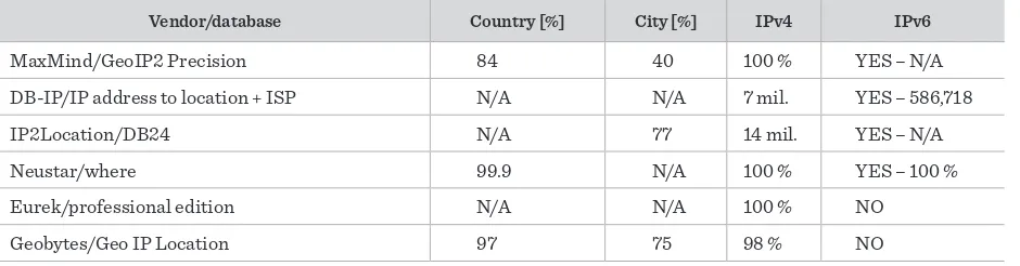
In this section, we study the claimed location accura-cy by major geolocation database providers. We sum-marize the found claimed accuracy in Table 1. The databases typically return geographical coordinates (latitude and longitude), country, region, and city. The Skyhook database ‘Hyperlocal IP Pro’ differs from others by returning region and city only when the es-timation reaches a certain level of trustworthiness.
Vendor/database Country [%] City [%] IPv4 IPv6
MaxMind/GeoIP2 Precision 84 40 100 % YES – N/A
DB-IP/IP address to location + ISP N/A N/A 7 mil. YES – 586,718
IP2Location/DB24 N/A 77 14 mil. YES – N/A
Neustar/where 99.9 N/A 100 % YES – 100 %
Eurek/professional edition N/A N/A 100 % NO
Geobytes/Geo IP Location 97 75 98 % NO
Table 1
Information Technology and Control 2017/3/46 336
MaxMind publishes the accuracy data for 23 coun-tries (www.maxmind.com/en/geoip2-city-data-base-accuracy). For the purpose of comparison at the country level, we use the maximum location error of 250 km to evaluate the result as correct. Based on this range, 4 % of the location queries are reported to be resolved incorrectly, and 12 % of location queries are reported to be unresolved (not-returned) at the coun-try level. For the city level, 48 % of the location ries give an incorrect city, and 11 % the location que-ries are unresolved. DB-IP does not publish any data on location accuracy, only the number of IP address space covered. IP2Location publishes a comprehen-sive location accuracy data for 250 countries (www. ip2location.com/data-accuracy). The published data cover only the city coverage (the country level is not included). For the purpose of comparison at the city level, we use the maximum error of 50 miles. Neustar does not publish any data on accuracy of their geolo-cation services. However, we found that the accuracy of the databases was evaluated by Pricewater- house Coopers (www.neustar.biz/ resources/ product-lit-erature/ neustar-ip- intelligence-pwc-audit). The result is 99.9 % accuracy for the country level. Neus-tar claims to cover all of the IP address space. Eurek does not provide any location accuracy information about their products. The only information provided is that it covers the whole IPv4 address space. Geo-Bytes provides some basic data about their accuracy (www.geobytes.com/ faq/). It claims to resolve 98 % of IP addresses with accuracy of 97 % at the country level. Another information published is that 80 % of returned locations are within the maximum error distance of 100 km and 75 % of locations are within the maximum location error of 50 km. ipinfo does not publish any accuracy related information. The same holds for Skyhook.
4. Related work
Comparing data from the related work is difficult due to the use of different evaluation techniques. An ex-ample is the use of different distance thresholds for the city-level accuracy. In the related work it varies from 40 to 100 km. Therefore, we use a different mea-sure to compare the related work. We work with the independent cumulative probabilities of locations
within a maximal error of 50, 100, 150, and 250 km. Shavitt and Zilberman [25] use a groundtruth data-set that is based on an algorithm which groups IP addresses into virtual Points of Interest (PoPs). The algorithm discovers the sets of the routers at the same location. For this purpose, they use latency mea-surements and topology discovery. The accuracy of the results depends on the PoPs identified locations. Six major geolocation databases are evaluated: Max-Mind, IP2Location, IPligence, HostIP, Netaculity, and Geobytes. We summarize the results in Table 2. As the source of the accuracy data, we use the cumu-lative probability function showing the database lo-cation deviation from the lolo-cations of the identified groundtruth PoPs.
Table 2
Cumulative percentage of estimated locations within maximum location error [km] – created from source [25] [%]
Vendor <50 <100 <150 <250
MaxMind 68 73 76 78
IP2Location 62 65 66 68
IPligence 73 75 76 78
HostIP 37 39 42 45
Netaculity 45 49 50 54
Geobytes 33 35 40 45
Table 3
Cumulative percentage of estimated locations within maximum location error [km] – created from source [27] [%]
Vendor <50 <100 <150 <250
IP2Location 28 34 47 57
MaxMind 15 22 32 45
337
Information Technology and Control 2017/3/46
IP2Location (DB11.LITE). The table shows the val-ues for the public IP addresses studied. The private addresses studied give larger values up to a maximum error of 400 km. After this value, the results are sim-ilar with no significant difference. We note that a cel-lular network is used in this study and such networks give worse results compared to general Internet net-works.
Huffaker et al. [12] evaluate eight databases. They point out the absence of a substantial groundtruth dataset. They propose a method to evaluate the ac-curacy by a centroid-based algorithm working with majority of location votes from the databases. The location accuracy in a form of cumulative probabili-ty is only provided for five databases: MaxMind Geo, MaxMind Lite, IPligence, Digital Envoy, and HostIP. For the data shown in Table 4, we use the location accuracy for the PlanetLab groundtruth dataset. The results show a better location accuracy most probably because of the use of the groundtruth dataset, which was created by using the location voting algorithm. Another reason is that the PlanetLab groundtruth dataset is strongly oriented towards the major cit-ies [15, 16].
Table 4
Cumulative percentage of estimated locations within maximum location error [km] – created from source [12] [%]
Vendor <50 <100 <150 <250
MaxMind 81 85 89 92
Digital Envoy 88 91 93 96
IPligence 78 82 85 89
HostIP 76 82 83 87
Table 5
Cumulative percentage of estimated locations within maximum location error [km] – created from source [24] [%]
Vendor <50 <100 <150 <250
InfoDB 50 63 70 80
MaxMind 35 42 50 63
IP2Location 10 15 18 20
Poese et al. [24] focus on the differences between the claimed accuracy by the database vendors and the real-case location accuracy. The accuracy is evaluat-ed by using a groundtruth dataset that was obtainevaluat-ed via a large European ISP. They create PoPs based on the network prefixes. The locations of the groundtruth nodes are obtained by using an internal naming scheme of the ISP. The databases studied are HostIP, IP2Location, InfoDB, MaxMind, and Software77. Ta-ble 5 shows the results for IP address blocks that are smaller than the groundtruth ISP prefixes.
Other papers that deal with database-based IP geolo-cation are [30, 8]. These papers do not give any results for the cumulative maximum location error probabil-ities, and they focus on different related topics, such as the covered IP address space.
By summarizing the related work, we show that there are very large differences in the results. The related work shows that:
1 from 10 to 88 % of the nodes can be located within
50 km range,
2 15-91 % of the nodes can be located within range of
100 km,
3 18-93 % of the nodes can be located within range of
150 km,
4 and 20-96 % of the nodes can be located within
range of 250 km.
The worst results were achieved when one ISP-based groundtruth dataset was used. The second worst re-sults were achieved when mobile devices were lo-cated. The best results were obtained when using a groundtruth dataset that was obtained from the cen-troid-based algorithm based on location votes from the databases.
5. Construction of error-free
groundtruth dataset
Information Technology and Control 2017/3/46 338
The groundtruth geographical locations were ob-tained by using in-built GPS in the used mobile devic-es. We also recorded the country, region, city, and ISP for each groundtruth IP address.
The groundtruth construction is as follows:
1 In order to keep the dataset free of the problems that described in the related work, we strictly fol-lowed the rule to use only one node per ISP in a city (i.e. there is only one node which belong to an ISP in a city). This restricted the size of the origi-nal dataset a lot. On the other hand, it assured the proper distribution of the nodes and the location accuracy results are not influenced by repeating the same or similar locations.
2 We additionally filtered the dataset to store only
the nodes that belong to same ISPs and, at the same time, situated in at least 10 different cities for each ISP involved. The reason is that the location da-tabases give the same or a small set of locations for the same-ISP nodes that are correctly located in many different places [27]. An example distri-bution of the nodes that belong to such an ISP is shown in Figure 3.
3 We aimed to cover a variation of cities in the
groundtruth. The cities covered are very small to very large, i.e. we did not focus only on major cities. The city population and area of the groundtruth nodes is shown in Figures 4 and 5. The median value for the city population is 16 925. The median value for the city area is 50 km2.
Figure 3
Example of same-ISP nodes used in groundtruth dataset After applying the proposed method to the orig-inal dataset, we obtained about 700 error-free groundtruth nodes. The trusted nodes were situated in 16 countries, 52 regions, and 270 cities. They were assigned to 319 ISPs.
6. Evaluation of location accuracy
6.1 Relative location accuracy
By using the groundtruth dataset constructed, we evaluated relative location accuracy in terms of the correctly estimated countries, regions, and cities. The results are shown in Figure 6. During this evaluation, we faced a particular problem of the place names which are sometimes different in English and in the
Figure 4
Groundtruth nodes in cities with different population
Figure 5
Groundtruth nodes in cities with different area
339
Information Technology and Control 2017/3/46
local language. Some of the databases return the En-glish form, but the others keep the local name. For a proper evaluation, we stored the English forms of place names in the groundtruth dataset. If a database returned a place name in the local language, we found its English form for a proper evaluation.
Figure 6
Relative location accuracy
12
The results show that the majority of the databases achieve nearly 100 % accuracy at the country level. The worst accuracy is achieved by the database Geo-Bytes which is around 80 %. There are much worse results for the region and city estimations. The best databases return around half of the estimations cor-rect at the region level. The worst database is again GeoBytes with about 20 % of the estimated correct regions. At the city level, the best databases give about 30 % of the estimations correct. We notice a signifi-cant drop for the Skyhook database which returns only about 15 % of the cities correctly. We, however, note that this database returns a city only when there is a high probability of a correct match.
6.2 Absolute location accuracy
We evaluated absolute location accuracy as the geo-graphical distance between the estimated and correct coordinates. We noticed great differences between absolute and relative location accuracy. A good exam-ple is the Skyhook database. Figure 7 shows cumula-tive probabilities of maximal location errors for each database. The most accurate database is Skyhook. However, regarding relative accuracy (Figure 6), Sky-hook gives the worst result at the city level. The rea-son behind this inconsistency is that Skyhook returns
a city only when the estimation is believed to be cor-rect, otherwise the city returned is null.
The most significant differences in absolute location error between all the databases are around a maximal error of 150 km. The best database gives about 90 % of the locations within this error range (Skyhook) while the worst returns only 45 % of the results within this error range (GeoBytes). This difference becomes smaller for large-errors that we separately study in section 6.6. All the databases return almost all loca-tions within maximum error range of 300 km except the database GeoBytes.
Table 6 provides specific numbers on absolute loca-tion accuracy. The standard devialoca-tion shows large variation of the location errors for the databases DB-IP and GeoBytes.
Figure 7
Cumulative probability of absolute location error
Table 6
Absolute location error details [km]
Database Mean Std Dev 1st q. Median 3rd q.
MaxMind 64 86 3 18 113
DB-IP 142 775 5 50 181
IP2Location 91 290 4 26 146
ipinfo 95 98 5 47 187
Skyhook 50 76 1 10 70
Neustar 93 100 6 51 181
Eurek 69 112 3 17 119
Information Technology and Control 2017/3/46 340
6.3 Effect of city area and population
Figures 8 and 9 show the relative location error change for different city areas and populations. The figures show the regression lines of the median lo-cation error values. Both figures indicate better ac-curacy with increasing city area and population. The reason for these accuracy changes is the source of location information that come from traffic measure-ment (more populated places generate more Internet traffic). This also holds for crawling and datamining the web servers for location data.
Figure 8
Location error change with different city area
Figure 9
Location error change with different city population
6.4 Effect of ISP assignment
The databases typically return the same or a small set of locations for the nodes assigned to the same ISP. We particularly study this phenomenon in Figure 10. The
figure shows the cumulative probability for the same-ISP nodes located within a maximum location error. The gap between the location error probabilities for the databases is smaller compared to the general case shown in Figure 7. The graph also shows generally worse cumulative probabilities. The databases again locate all the nodes within a maximum error distance of 300 km, except the database GeoBytes.
Figure 10
Absolute location error of nodes belonging to same-ISP
The specific numbers of this evaluation are shown in Table 7. The database with the lowest median location error is again Skyhook. However, the median value for the database Skyhook is about 50 km worse, com-pared to the general multi-ISP scenario.
Table 7
Location accuracy details for nodes belonging to same ISP [km]
Database Mean Std Dev 1st q. Median 3rd q.
MaxMind 118 86 35 112 201
DB-IP 144 78 78 158 206
IP2Location 118 88 38 107 205
ipinfo 145 91 44 171 215
Skyhook 87 81 21 61 138
Neustar 145 77 80 159 204
Eurek 117 88 35 102 201
341
Information Technology and Control 2017/3/46
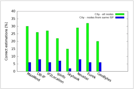
We also study relative errors for the same-ISP nodes. Figure 11 shows the correctly estimated cities. We con-clude that the databases estimate approximately one quarter (on average) of the cities correctly when the same ISPs are used compared to multiple ISPs usage.
Figure 11
Correct city estimations for nodes belonging to same-ISP
6.5 Unresolved locations
The previous results show that the databases do not resolve (do not return) a location for every node re-quested. Figure 12 shows the not-returned relative lo-cations (country, region, and city) and the coordinates. The results indicate that the best database in terms of the resolved locations is DB-IP (100 % locations re-turned), IP2Location IP (100 % locations rere-turned), Neustar, and GeoBytes. We note that Skyhook returns
a relative location only when a certain level of trust-worthiness is reached. We also note that these num-bers do not indicate the location accuracy as some databases return the capital city or the centre of a country when a better estimation is not known. This is better seen when Figures 12 and 6 are compared.
6.6 Large errors
A common problem of IP geolocation is that some lo-cations are returned with a great error. The previous observation shows the percentages of such large-er-rors in Figure 7. It shows that there is a percentage of location errors over 200 km for each database. The database GeoBytes shows the worst results for loca-tion errors over 200 km.
We demonstrate the problem of large errors in Fig-ure 13. The green/bright marks show the locations estimated with some large errors. Additionally, one of the red/dark marks shows an estimated location with an extremely large error. The node is correctly situat-ed in Paris, France but the estimatsituat-ed location points to Istanbul, Turkey.
Figure 12
Unresolved locations
Figure 13
Example of very large location errors
2017/3/46 342
7. Conclusions
The accuracy of client-independent IP location was high at the country level where it reached almost 100 % of correct estimations (except the database GeoBytes). In this case, IP geolocation databases can be trusted. The region-level accuracy was of a worse value, best databases gave around 50 % of correct es-timations. The best city-level accuracy was around 30 %. Considering the error distances between the estimated and correct coordinates, the best median error was 10 km for the database Skyhook. We note that all these values were obtained for a high number
Figure 14
Databases differences for large location errors (last decile) of small cities involved in the dataset (the median city population was 17 000). The city population and area have a significant impact on location accuracy. Furthermore, node association to the ISPs also have a significant impact on location accuracy. Multiple nodes that were assigned to the same ISP but in different cities were located less ac-curately than the nodes that were assigned to different ISPs. There was a 50 km worse median location error for the best performance database Skyhook. Also, the databases estimated approximately one quarter (on average) of the cities correctly when the same ISPs were used compared to multiple ISPs usage.
The percentages of returned locations do not correlate with location accuracy. This was particularly apparent for the correctly estimated and unresolved cities. Finally, we noticed great differences between absolute and relative location accuracy. Some databases may return a city or region only when there is a high prob-ability of a correct match so as not to confuse the users.
Acknowledgments
Research described in this paper was financed by the National Sustainability Program under grant LO1401. Infrastructure of the SIX (Sensor, Information and Communication Systems) Center was used.
References
1. Backstrom, L., Sun, E., Marlow, C. Find Me if You Can: Improving Geographical Prediction with Social and Spatial Proximity. Proceedings of the 19th Internation-al Conference on World Wide Web, ACM, 2010, 61-70. https://doi.org/10.1145/1772690.1772698
2. Balakrishnan, H., Lakshminarayanan, K., Ratna-samy, S., Shenker, S., Stoica, I., Walfish, M. A Lay-ered Naming Architecture for the Internet. Pro-ceedings of the 2004 Conference on Applications, Technologies, Architectures, and Protocols for Com-puter Communications, ACM, 2004, 343-352. https:// doi.org/10.1145/1015467.1015505
3. Bo, H., Cook, P., Baldwin, T. Geolocation Prediction in Social Media Data by Finding Location Indicative Words. Proceedings of the 24th International
Confer-ence on Computational Linguistics (COLING 2012), 2012, 1045-1062.
4. Burget, R., Komosny, D., Kathiravelu, G. Topology Aware Feedback Transmission for Real-Time Control Protocol. Journal of Network and Computer Applica-tions, 2012, 35(2), 723-730. https://doi.org/10.1016/j. jnca.2011.11.005
5. Fioreze, T., Heijenk, G. Extending DNS to Support Geo-casting Towards VANETS: A Proposal. IEEE Vehicular Networking Conference (VNC) 2010, 2010, 271-277. https://doi.org/10.1109/VNC.2010.5698258
343
Information Technology and Control 2017/3/46
Vehicular Networking Conference (VNC) 2011, 2011, 70-77. https://doi.org/10.1109/VNC.2011.6117126 7. Graham, M., Hale, S., Gaffney, D. Where in the World
Are You? Geolocation and Language Identification in Twitter. The Professional Geographer, 2014, 66(4), 568-578. https://doi.org/10.1080/00330124.2014.907699 8. Gueye, B., Uhlig, S., Fdida, S. Investigating the
Impre-cision of IP Block-Based Geolocation. In: Passive and Active Network Measurement, Lecture Notes in Com-puter Science, Springer, 2007, 4427, 237-240. https:// doi.org/10.1007/978-3-540-71617-4_26
9. Gueye, B., Ziviani, A., Crovella, M., Fdida, S. Con-straint-Based Geolocation of Internet Hosts. IEEE/ ACM Transactions on Networking, 2006, 14(6), 1219-1232. https://doi.org/10.1109/TNET.2006.886332 10. Guo, Ch., Liu, Y., Shen, W., Wang, H., Yu, Q., Zhang, Y.
Mining the Web and the Internet for Accurate IP Ad-dress Geolocations. IEEE INFOCOM 2009, 2009, 2841-2845.
11. Hegr, T., Bohac, L., Kocur, Z., Voznak, M., Chlumsky, P. Methodology of the Direct Measurement of the Switch-ing Latency. Przeglad Elektrotechniczny, 2013, 89(7), 59-63.
12. Huffaker, B., Fomenkov, M., Claffy, K. Geocompare: a Comparison of Public and Commercial Geolocation Databases. CAIDA Tech Report, University of Califor-nia, 2011.
13. Katz-Bassett, E., John, P., Krishnamurthy, A., Wether-all, D., Anderson, T., Chawathe, Y. Towards IP Geolo-cation Using Delay and Topology Measurements. Pro-ceedings of the 6th ACM SIGCOMM Conference on Internet Measurement, ACM, 2006, 71-84. https://doi. org/10.1145/1177080.1177090
14. Komosny, D., Balej, J., Sathu, H., Shukla, R., Dolezel, P., Simek, M. Cable Length Based Geolocalisation. Prze-glad Elektrotechniczny, 2012, 88(7a), 26-32.
15. Komosny, D., Pang, S., Pruzinsky, J., Ilko, P., Polasek, J. PlanetLab Europe as Geographically-Distributed Test-bed for Software Development and Evaluation. Advanc-es in Electrical and Electronic Engineering, 2015, 13(2), 137-146. https://doi.org/10.15598/aeee.v13i2.1245 16. Komosny, D., Pruzinsky, J., Ilko, P., Polasek, J., Masek, P.,
Kocatepe, O. On Geographic Coordinates of PlanetLab Europe. IEEE 38th International Conference on Tele-communications and Signal Processing (TSP), 2015, 642-646. https://doi.org/10.1109/TSP.2015.7296342 17. Komosny, D., Voznak, M., Bezzateev, S., Kathiravelu, G.
The Use of European Internet Communication
Prop-erties for IP Geolocation. Information Technology and Control, 2016, 45(1), 77-85. https://doi.org/10.5755/j01. itc.45.1.11062
18. Komosny, D., Voznak, M., Kathiravelu, G., Sathu, H. Esti-mation of Internet Node Location by Latency Measure-ments – The Underestimation Problem. Information Technology and Control, 2015, 44(3), 279-286. https:// doi.org/10.5755/j01.itc.44.3.8353
19. Krajsa, O., Fojtova, L. RTT Measurement and Its De-pendence on the Real Geographical Distance. IEEE 34th International Conference on Telecommunica-tions and Signal Processing, 2011, 231-234. https://doi. org/10.1109/TSP.2011.6043737
20. Laki, S., Matray, P., Haga, P., Sebok, T., Csabai, I., Vat-tay, G. Spotter: A Model Based Active Geolocation Service. IEEE Conference on Computer Communica-tions, 2011, 3173-3181. https://doi.org/10.1109/INF-COM.2011.5935165
21. Moravek, P., Komosny, D., Burget, R., Sveda, J., Handl, T., Jarosova L. Study and Performance of Localization Methods in IP Based Networks: Vivaldi Algorithm. Jour-nal of Network and Computer Applications, 2011, 34(1), 351-367. https://doi.org/10.1016/j.jnca.2010.06.014 22. Moravek, P., Komosny, D., Simek, M., Sveda, J., Handl,
T. Vivaldi and Other Localization Methods. TSP 2009: 32nd International Conference on Telecommunica-tions and Signal Processing, Asszisztencia Congress Bureau, 2009, 214-218.
23. Percacci, R., Vespignani, A. Scale-Free Behavior of the Internet Global Performance. The European Physical Journal B – Condensed Matter and Complex Systems, 2003, 32(4), 411-414. https://doi.org/10.1140/epjb/ e2003-00123-6
24. Poese, I., Uhlig, S., Kaafar, M., Donnet, B., Gueye, B. IP Geolocation Databases: Unreliable? ACM SIGCOMM Computer Communication Review, 2011, 41, 53-56. https://doi.org/10.1145/1971162.1971171
25. Shavitt, Y., Zilberman, N. A Geolocation Databases Study. IEEE Journal on Selected Areas in Communica-tions, 2011, 29(10), 2044-2056. https://doi.org/10.1109/ JSAC.2011.111214
26. Sousa, A., Costa, A., Santos, A., Meneses, F., Nicolau, M. Using DNS to Establish a Localization Service. IEEE International Conference on Indoor Positioning and Indoor Navigation 2014, 2014, 385-392. https://doi. org/10.1109/IPIN.2014.7275506
Information Technology and Control 2017/3/46 344
and Active Measurement, 13th International Con-ference, Springer, 2012, 7192, 115-167. https://doi. org/10.1007/978-3-642-28537-0_16
28. Voznak, M., Rozhon, J., Ilgin, H. Network Delay Varia-tion Model Consisting of Sources with Poisson‘s Proba-bility Distribution. Proceedings of the 15th WSEAS In-ternational Conference on Computers, WSEAS, 2011, 240-244.
29. Wong, B., Stoyanov, I., Sirer, E. Octant: A Comprehen-sive Framework for the Geolocalization of Internet Hosts. Proceedings of the 4th USENIX Conference on Networked Systems Design & Implementation, USE-NIX Association, 2007, 313-326.
30. Zander, S. How Accurate is IP Geolocation Based on IP Allocation Data? Technical Report 120524A, Swin-burne University of Technology, 2012.
This paper deals with finding the geographical location of Internet nodes remotely with no need to communi-cate with the nodes locommuni-cated (client-independently). IP geolocation is used in a number of areas, such as content personalisation, on-line fraud prevention and detection, and digital media law enforcement. One of the main concerns when studying the accuracy of client-independent geolocation is the groundtruth dataset. As we show in the related work, the used groundtruth influences the results a lot. We construct an error-free groundtruth dataset consisting of nodes with GPS-precise locations. We also record the country, region, city, and ISP for each groundtruth node. Using the created groundtruth, we study the accuracy of eight IP location databases in a number of scenarios, such as effect of city area and population, effect of ISP assignment, and number of not-returned locations.
Straipsnyje aptariamas geografinės interneto mazgų padėties aptikimas nuotoliniu būdu, kai nereikia susisiekti su pačiais mazgais (nepriklausomais nuo kliento). IP adresų geografinė informacija naudojama daugelyje sričių, pavyzdžiui, turinio personalizavimas, sukčiavimo prevencija ir aptikimas internete bei skaitmeninės žiniasklai-dos teisėsauga. Vienas iš svarbiausių aspektų, tyrinėjant nuo kliento nepriklausomą geografinę informaciją, yra etaloninių reikšmių duomenų rinkinys. Kaip rodo ankstesnieji tyrimai, naudojamos etaloninės reikšmės turi daug įtakos rezultatams. Autoriai pristato savo sukurtą klaidų neturintį etaloninių reikšmių duomenų rinkinį, sudarytą iš mazgų su tiksliomis, GPS pagalba nustatytomis lokacijomis. Kiekvienam etaloninės reikšmės mazgui taip pat padaromas šalies, regiono, miesto ir ISP įrašas. Naudodamiesi savo sukurtomis etaloninėmis reikšmėmis, autoriai tiria aštuonių IP lokacijų duomenų bazių tikslumą skirtinguose scenarijuose – tokiuose, kaip miesto vie-tovės ir populiacijos įtaka, interneto ryšio tiekėjo paskyrimo ir negautų atsakymų, įtaka.