Geology Field Mapping
Adiela, U.P
1, Omoboriowo A.O
2and Elias Pius
31Department of Petroleum Engineering, Nigerian Agip Oil Company, Port Harcourt, Nigeria. 2Department of Earth Sciences, Federal University of Petroleum Resources, Effurun, Nigeria. 3Department of Geology, Federal University of Technology, Minna, Nigeria.
Article Received: 09 October 2017 Article Accepted: 29 November 2017 Article Published: 17 December 2017
1.INTRODUCTION
The study area lies within the north central portion of the Nigerian Basement Complex rock which is characterized
by three lithofacies: the migmatite gneiss complex, the low schist belt and the older granites (Olarewaju, et al,
1996; Olasehinde, 1999).Particular to the area is the granite-gneiss and granitic rocks of different grain sizes,
outcropping at different locations within the area with noticeable fractures and joints. The joints are of two
generations depending on their orientations, some trending NNE-SSW and the other NE-SW (fig.3). In most cases
the joints are filled with Quartzofeldsparthic veins, while others are fairly well exposed along the river channel.
The values of the joints directions range between 120° and 160°. Foliation was also noticed on some of the outcrops
in the area. The outcrops in the area are randomly located at the south eastern parts
2.AIMOFTHEMAPPINGPROJECT
The aim of this mapping project is to train students in the various aspects of geological field mapping with the view
of helping the students to accurately identify and describe rock types in the field.
3.LOCATIONEXTENTANDACCESSIBILITY
The mapped area is located between latitude 6°36 and—6°42’N and longitude 9°26’E—9°30’E on the Paiko sheet
185 Northwest. The mapped area extends approximately 7.4km in length and 10.5km in breadth. The extent of the
mapped area is approximately 80km2 on a scale of 1:40,000. The mapped area is accessible by the Minna — Suleja
highway which divides the area into two parts. Footpaths leading to the various villages give easy access to
different parts of the mapped area.
4.CLIMATEVEGETATIONANDLANDUSE
The mapped area lies within the middle belt region of Nigeria. It is characterized by two major seasons; A dry
season which lasts for about six to seven months from November to April with very low humidity accompanied by A B S T R A C T
The mapped area which is located between latitude 6°36’N—6°42’N and longitude 9°26’E—9°30’E on the Paiko sheet 185 North—west covers and approximate are3of 80km2 in Paikoro Local Government Area of Niger State. The mapped area covered in this project is composed of granites of the older granites suite of the Nigerian Basement complex which can be distinguished into; leucocratic granite which is the most extensive and covers about 50% of the total area. Biotite granite who forms 35—40% and is the second largest outcrop of rocks in the mapped area which are mostly abundant in the western portion and finally granodiorite which makes up 10% of the total area is found in the North—Central portion of the mapped area. The textures of the various granitic rocks varies from medium to ceare grained textures.
the North—East trade winds which is usually the harmattan periods. Maximum temperature conditions between
30°C and 36°C are recorded between December and Mid—January.
There is also the rainy season which lasts for about five to six months usually begins from April to November. This
is usually characterized by a high humidity and excessive heat.
The average annual rainfall is between 150 — 250mm and usually peaks between July and September. This is
usually brought about by the south—East trade winds which are moisture laden.
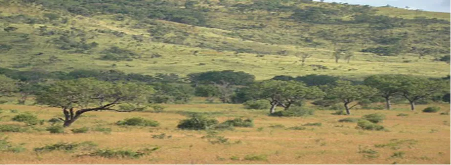
Figure 1: Typical vegetation of the study area
The vegetation in this area is typically that of the guinea savanah which is characterized by shrubs and very tall
grasses with scattered trees of different species such as mango, cashes mahana, and sheabutter which are of
economic importance. The grasses include elephant grass, goat weed, Northern gamba etc.
The major agricultural activities in the areas are subsistence farming and cattle rearing by the nomadic fulanis.
Farming which is at a subsistence level include crops like yam, rice, guineacorn, millet, cowpea, and grundnuts.
5.RELIEFANDDRAINAGE
The area generally has a gentle topography with occasional hills. However, the eastern portion of the area has a
rugged topography with ridges running from the north to southern portion. They stand up to 1500 ft about the
surrounding country. The area is drained mainly by River maidna with smaller stream channels running north south
of the area. The area is usually swampy during the rainy season and dry during the dry season.
6.LITHOLOGYANDFIELDRELATIONS
6.1GENERAL DESCRIPTION AND ROCK TYPES
The mapped area is made up of mainly granites. These are of three types and are part of the Older Granite suite
many areas. The rocks are compositionally similar and can only be distinguished mainly by their textural
relationship which has slight local variaitons. The granites were also intruded by pegmatites and quartz vein in
some areas.
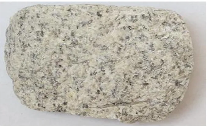
7.LEUCOCRATICGRANITE
This is a light colored and homogenous coarse to medium grained granite. In the field, the rocks show evidences of
weathering indicated by the scattered boulders of the rock on display on the outcrop.
Figure 2: Granitic Rock
In hand specimen, however, the predominant mineral is feldspar and quartz. Hiotite patches are also seen. In the
thin section, the minerals identified are muscovite, plagioclase, quartz, Biotite, chlorite and microcline.
8.QUARTZ
This is a medium grained subhedral to enhedral crystal. It occurs in the intenstices between the muscorite and
plagioclase. Interference coloriz varies from white to grey to yellow. It has neither twinning, cleavage nor any form
of mineral alterations. It constitutes a smaller composition in comparison with other minerals and forms about
20—25% of the rocks total mineral composition.
9.MUCOVITE
This forms one of the dominant minerals in the rock. It has a fan relief and shows a weak plleochroism. The crystal
is enhedral and tabular in shape. Under the analyzer, it shows interference colours ranging from pinkish blue to
yellowish brown. It has a good twinning plane with alterations of minerals to flakes of sericites.
10.PLAGIOCLASE
This is a medium to coarse grained mineral. Interference colour ranges from light to dark grey. It exhibits twinning
11.CHLORITE
It has a green colour under high relief under plane polarised light. It occurs as anhedral, fine grained crystals. Under
cross polar, it shows green interference colour and occurs as an alteration product of biotite.
12.BIOTITE
Biotite occurs as the least mineral constituent of the rock. It is subshedral to anhedral, pleochroic from brown to
yellowish green or dark green in terms of interference colour under crossed polar.
13.BIOTITEGRANITE
These forms about 35 to 40% of the exposed outcrop in the mapped area. They are made up of mainly granites and
granodisinters. They range from light to dark colours that are made up of dark, flaky minerals indicating abundance
of biotite with quartz and feldspar.
They have a homogenous composition with local variations in grain sizes from medium to coarse grain. They are
somewhat equigranular and show slight gradation southwards.
The rocks also have several joints which randomly cross—cut outcrops. These joints are filled with quartz veins
appearing as dykes. The rocks are weathered to varying extents and have and approximate north—south trend.
In handspecimen, biotite granite is dark grey in colour, medium to coarse grained and equigranular. In the thin
section, the rock is medium to coarse grained. Essential mineral constituents are quartz, biotite, microchrie, epidote
and opaque minerals.
14.BIOTITE
Biotite occurs as a dominant magic mineral in a lath—like pattern. It is medium grained (about 2mm) Biotite is
pleochroic from yellowish green to dark brown.
15.PLAGIOCLASE
Plagioclase shows subhedral and rectangular crystals, exhibiting Lamellar twinning. They are clouded as a result of
alteration or inclusion and are zoned.
16.MICROCLINE
These have very large crystals, surrounded by muscovite and biotite grains. The show corss—hatch twining,
anhedral and cloudy.
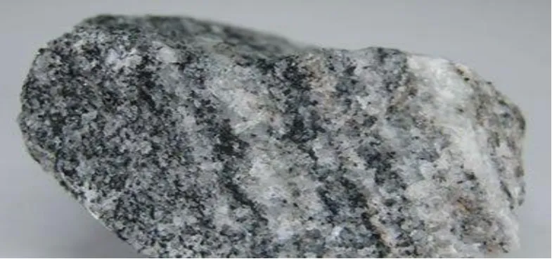
17.GRANODIORITE
Granodiorites are predominant in the North—central portion of the mapped are and constitutes about 10% of the
Figure 3: Granodiorite
18.STRUCTURALGEOLOGY
18.1 Foliation
No major structures were found in the mapped area. However, foliation is seen in only one location where gneisses
and granites occured together as migmatites.
Figure 4: This has alignment of shining mica and felsic minerals and is fine to medium grained. The medium to
coarse grained granite on the other hand has feldspar grains randomly oriented and hence very weakly foliated or
not foliated depending on the degree of grain orientation.
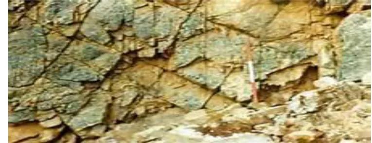
18.2 Joints and Fractures
Joints and fractures little almost all the outcrops in the mapped area. However, there are two sets of joints
Figure 5: The mapped area is also well jointed, most of which cross—cut the host granitic rocks and have been
filled with quartz veins.
18.3FOLDS
There were no major folds or faults in the mapped area. However, small recumbent and isoclinal fold with foliation
parallel to the axial plane.
Figure 6: Folds in Rocks
19.GEOLOGICALHISTORY
The Nigerian basement has undergone a complex history of deformations and igneous activities that are yet to be
unravelled.
Russ (1957), distinguished between the Older Granites, gneinic complex and the younger metasedimentary
sequence which was folded, faulted and metamorphosed during which an earlier period of sedimentation, intrusion
and metamorpism within the compled was recognized.
Grant (1969), recognized an ancient crystalline basement that has been reactivated during the Pan African Orogny
Field relationships of three granites show that the granites have different ages (Agibade, 1982) but are within the
Pan—African (600±100 my) age spectrum.
Older Granites of the studied area may therefore represent reworked Older basement or deformed rocks that were
partially melted and intruded as granites.
More recently, Turner (1983), Ajibade and Wright (1989), observed that the Older Granites are orogenic having
caic—alkaline characteristics probably related to subduction zones. They therefore revealed that the
Togo—Benin—Nigerian Basement of which the granites are part of the Older Granites suite of the Nigerian
basement may represent allochionous tenains which became welded together by continental collision.
20.GEOLOGYANDCONCLUSION
The mapped area is poorly mineralized and the economic aspect of geology available in the mapped area is
presently not fully exploited. The economic potentials of the geology of the mapped area is not fully exploited yet.
The major rock type is this area is granite and can be used for building and construction works.
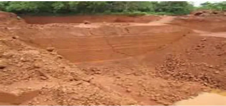
21.LATERITE
These are found in a few places. It can be used for rural ward surfacing. However, the iron content is very low for it
to be industrially viable.
Figure 7: The excavation of laterite in the study area
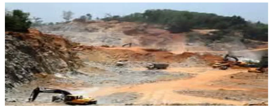
22.QUARRYING
The mapped area has plenty of granite outcrops granites can be quarried and used for construction and building
purposes such as roads, dams, airports and residential houses. They could also be cut and polished for decorative
Figure 8: A quarry location in the study area.
23.CLAY
The mapped area has deposits of clay. The Chanchaga Clay Factory located at Pqgo manufactures bricks and clay
blocks for building constructions. This is the major geologically oriented economic activity in the mapped area.
24.CONCLUSION
Field relationships have shown that granites are intrusive and of inagmatic origin. The rocks of the mapped area are
representative of the basement complex rocks of Nigeria.
REFERENCES
[1] Ajibade, A.C. Woakes, M. and Rahaman, M.A. (1987) Proterozoic Crustal development in the Pan—African
Regime of Nigeria. A kroner (ed) American Geophysical Union. pp 259-271.
[2] Ajibade, A.C. (1976), Provincial classification and correlation of the schist belts of North Western Nigeria: In
Geology of Nigeria ed by C. A. Korgbe. Elizabethan pub. House Lagos. pp 85-90.
[3] Abjibade, A.C. Fitches, W. K. and Wright J.B. (1979). The Zungeru Mylonites Nigeria: Recognition of a
major tectonic unit. Rev. de Geol. Phys. 21(5) pp 359-363.
[4] Coaray, P.G. (1974), Some aspect of precambrain geology of Nigeria. A review Journal of mining and geology
Vol. 8 (pp 17-42).
[5] Falconer J.D. (1911). The Geology and Geography of Northern Nigeria Macmillian London.
[6] Oyawoye, M.0. (1972), The basement complex of nigeria in African Geology ed. by T.F.J. Dessanvegie and
A.J. Whitetnan University of Ibadan. pp 66-102.