Geology of parts of Gboko and Makurdi Local
Government Areas, Benue State, Nigeria
Madu Anthony Joseph Chinenyeze
1*and Bridget N. Ozibo
21* Department of Geology, College of Physical and Applied Sciences, Michael Okpara University Umudike, Abia State,
Nigeria.
2 Department of Geology/Geophysics/Physics, Federal University, Ndufu-Alike-Ikwo FUNAI, Ebonyi State, Nigeria. The study area lies within the middle Benue trough consisting of a sedimentary terrain, and igneous rocks at the northern part. The area has three drainage basins separated by a water divide that trends nearly north-south. The sedimentary terrain comprises mainly sandstone of Makurdi Sandstone with common fold axes trending Southwest-Northeast. It has grain size distribution and stratigraphic signatures suggestive of fluvial environment. The limestone unit is of a smaller area and circumscribed by the sandstone. Fossils identified in the limestone include mostly pelecypods, gastropods and ammoids. The limestone unit is a probable member of Eze-Aku shale. Evidence of igneous activity in the study area is the emplacement of extrusive and intrusive rocks. The extensive rock is porphyritic basalt, with olivine phenocrysts, augite and analcite. The mineral assemblage suggests that the basalt is of alkaline affinity. The intrusive rocks are dolerite and felsic dolerite, with predominance of lime-bearing plagioclase over all other minerals in the felsic dolerite.
Key words: Sediments, sandstone, limestone, igneous activity, sedimentary structures.
INTRODUCTION
The study area lies within the Benue valley of Nigeria. It is located between latitudes 7030’N and 7054N and
longitudes 8048E and 9000E. The area occupies the
southeastern portion of Makurdi Sheet 251 and scale 1:100, 000.
The major road which runs through parts of the area is the Makurdi-Gboko road. Other access roads include: Abinsi-Kuatansule road and Makurdi-Gbajimba road. There are also numerous footpaths that link different parts of the area. Figure 1 shows the location of the study area in the Nigerian map.
Topography and Drainage
The area comprises low-lands of about 300ft above sea level, near the banks of River Benue and its main tributary-River Katsina-Ala. There are some scattered
hills occurring in the area to form a nearly undulating topography.
Most parts of the low-lying areas fall below 500ft above sea level. They are densely dissected by streams, which flow into River Katsina-Ala in the southeastern portion of the mapped area, while on the southwestern section, the streams flow into river Mu – another tributary of River Benue which lies outside the mapped area.
*Corresponding author: Madu Anthony Joseph Chinenyeze, Department of Geology, College of Physical and Applied Sciences, Michael Okpara University Umudike, Abia State, Nigeria. Email: ajchinenyezem07@yahoo.com
Then sub tributaries flow from an elevated plain of about 600ft above sea level, which serves as the main water divide of the area. The mapped area has three drainage basins which are separated by water divide. It is along part of the axis of the water divide that the Makurdi-Gboko road was constructed.
Prominent hills in the area, north of Gbajimba, are products of igneous activity. The hills range mostly beyond 500ft above sea level and are commonly covered by extrusive igneous rocks. There are also hills which are covered by laterites in the eastern portion of the mapped area.
Geologic Setting
The area is within the southwestern margin of the middle Benue valley. It is included in the Benue trough in which a thick pile of marine and fluvio-deltaic sediments was deposited during the lower Cretaceous. The deposition commenced in the Albian with the emplacement of the Asu River Group of marine sediments. Sediments within the trough became folded in the Santonian, with the fold axes mostly trending northeast-southwest. The sediments were faulted and eroded. The erosion activity continued until the igneous activities began in the post-Santonian times (Offodile, 1976).
Probably the igneous activities of this time gave rise to the extrusive and intrusive rocks in the mapped area. The intrusive rocks of the area consist of a dolerite stock and a plug of felsic area. The volcanic rock (porphyritic basalt) extruded over the host sandstone rock.
Some work has been done in this area though on a regional scope. Farrington (1952) outlined an Albian to Maestrichtian stratigraphic sequence for the middle Benue valley. He noted the occurrence of alkaline and non-alkaline igneous rocks in the Benue valley.
The area is contained in part of the geological map of Nigeria, Sheet 64, on scale 1:250.000, which was published by the shell.
Cratchley and Jones (1965) carried out a geophysical survey of the Benue valley and discovered that the trough has an axial positive Bouguer anomaly, being flanked on both sides by elongate negative anomalies. This is in line with the proposed origin of Benue trough from rifted depression. However, Wright (1976) noted that no geological evidence has indicated rift faulting in most parts of the Benue valley margins.
Offodile (1976) outlined the lithologic sequence of Cretaceous age occurring in the south-middle Benue valley. He noted that the Keana formation is a lateral equivalent of the Makurdi formation in southern part, and also equivalent to the Muri sandstone in the northern part. He however, remarked that the lithologic units are progressively younger in age from the NE to SW.
Kogbe et al, (1978) grouped the Makurdi sandstone into
Micaceous and feldspathic types, and also noted the folding of the sediments with SW-NE fold axes.
Nwajide C.S. in a conference held by the Nigerian Society of Geosciences in 1981 evaluated the stratigraphic sequence of the Makurdi Sandstone, using Markov chain analysis, which yielded series of fining upward motifs. He suggested that the Makurdi sandstone is of fluvial environment.
OBJECTIVE OF STUDY
The aim of the mapping was to produce a detailed geology of the area. The provenance and paleo-environment of deposition of the sedimentary rocks, and delineate the occurring igneous rocks in the area.
METHODOLOGY
Ground investigation was conducted to map the detailed geology of parts of Gboko and Makurdi Local Government areas. Field work was done at 2 different seasons, and the last of which was a detailed land trekking Geological mapping. The bushes, streams, and physiographic hills and features surveyed for two weeks, and fresh sedimentary and igneous rock samples were collected for analyses.. Thin sections, microscope studies, and other laboratory analyses were carried out in the Department of Geology laboratory. From the determined chemical composition of the rocks, and minerals, various rock types were confirmed/established.
FINDINGS AND ANALYSES
Lithologic Distribution and Stratigraphic
Relationships
The sedimentary rocks of the mapped area consist of sandstone and unbedded limestone. The sandstone rock out crops in many parts of the mapped area, including banks of some stream channels in Mbako, where they display numerous ripple marks. Road-cut exposures showed cross- bedding of the sandstone-siltstone-shale near Ortese area. The sandstone is exposed as flaggy and horizontally bedded fine grained sandstone with siltstone intercalations in Wannune area.
The unbedded limestone is exposed at Agasha, Ihon and parts of Mbako-northeast areas. It covers a lens-shaped area of about 23km2 (figure 3). The limestone rock type is
highly fossiliferous, in contrast to the sandstone unit- that circumscribes it.
Figure 1. Showing location of the study area, covering Makurdi and Gboko Local Government Areas.
Table 1. Modal Analysis of Sandstone Sample MA/81/231
MINERAL CONSTITUENTS %
QUARTZ 75
FELDSPAR 6
CALCITE-CEMENT 12
MICA (Biotite (Muscovite
3 2
MAGNETITE
ZIRCON 2
STAUROLITE
Sandstone Unit
The sandstone is mostly grey colored and varies in textures from fine to medium grained. They are cross-bedded and rippled in most locations. Sandstones that outcrop along stream banks in Mbako, Uuma and near Kugwa areas are medium grained and show numerous ripple marks. Some of the outcrops have been weathered and fresh samples commonly contain copious flakes of micas, and are less indurated. Some fine-grained massive sandstone occur at the bank of a sub tributary of River Kastina-Ala, in southern Wanzum Amagwa. The rock is a pink colored highly indurated sandstone possessing discrete dark-brown colored weathered surface that are mostly less than 3.0cm long.
In Wannune district, road-cut exposures display flaggy horizontally bedded fine grained sandstone which has thin intercalations with siltstone. At location MA/81/201’ in
Wannune, there is an exposure of fine grained sediments, comprising fine-grained sandstone and mottled siltstone, which is overlain by boulders of late rites. The fine-grained sandstone portions in the mapped area are characterized by intense late rites and laterization. This is evident on the weathering of the fine-sediments, and also on the development of big late rite-roof which overlies a floor of fine sandstone at Abulu stream.
Figure 2. Showing Grain size Distribution of the Sandstone in the area.
A road-cut in south of Wannune exposes sequences of sandstone and siltstone. The siltstone layer is commonly mottled with shale at the top.
The sandstone layers are brown to grey colored, and range from medium grained at the base to finer grained overlying sandstone layers. The sediments at this location – MA/81/214 are locally jointed with the joint-zone of about 5cm wide being filled with siltstone. The trend of the joints includes 61 azimuths and 76 azimuths.
PETROGRAPHY
The model analysis of the sandstone is given in table 1, and the petrographic data in table 2. The principal mineral constituent of the rock is quartz. Feldspar is
present in the sandstone though not in high amount. Few mica flakes, iron oxide, zircon, and staurolitc are also present.
The sandstone is texturally fine grained, comprising of detrital minerals that range from sub angular to sub rounded, elongate to equant shapes. The grain size ranges from 0.10mm to about 0.20mm, though some polycrystalline quartz grains and eldspar ‘blados’ have diameters ranging 0.2cm to 0.3cm. The sandstone is texturally immature.
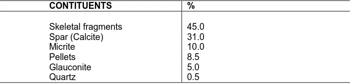
Table 2. Modal Analysis of the Limestone Sample MA/81/201
CONTITUENTS %
Skeletal fragments 45.0
Spar (Calcite) 31.0
Micrite 10.0
Pellets 8.5
Glauconite 5.0
Quartz 0.5
commonly display undulose extinction, though more clearly observed in the elongate and angular grains. About 75% of the sandstone is composed of quartz. The feldspars in the rock occur as subangular grains. Most of the feldspars are twinned dominantly displaying multiple twinning. They yield an average plagioclase composition of An40. Some grains and fragments of the
feldspar to have been altered and are observed as cloudy and stippled grains.
The feldspars and some of the quartz grains are separated from component grains by calcite cement which is the void materials of the sandstone. There are some elongate flakes of muscovite (mica) which have been mostly bent and sandwitched by sutured and angular grains of quartz. The heavy minerals such as magnetite occur as tables of opaque mineral constituents which float on the calcite cement. The zircon and staurolite detrital grains occur in various shalpes and are marked by high relief.
Using pettijohn’s (1975) classification of sandstone on the basis of the amount of the quartz, feldspar and rock fragment in the rock. The amount of cement in the rock is 12%, thus less than 15%
Quartz = 75 Feldspar = 7 Rock fragments = -
82
The amount of quartz and feldspar are corrected to 100% to give 91% and 8.45% respectively. These corrected amounts of auarts and feldspar contained in the sandstone classify it as a subarkose.
Grain Size Analysis
Reports of the sieve analysis of two samples of the sandstone unit were satisfactory.. Data available in the above tables were used in calculating the statistical parameters , using the inclusive graphic measures of folk and word (1957). The result of the analysis show that the sandstone is medium grained, with average grain size of about 0.25mm to 0.35mm. It is moderately well sorted, negatively skewed and mesokurtic. The negative skewness implies that more grains of the sandstone are slightly coarser than the average grain-size. The kurtosis
(mesokurtic) indicates a cluster of more moderately sorted medium-sized grains between the finer and coarse grains.
The histogram plots obtained from the analysis from the examples are shown in figure 2. They show bimodal distribution of the grain sizes.
Limestone Unit
This unit consists of discrete tabular boulders of dark-grey fossiliferous limestone rock. It outcrops in Agasha, iron and parts of Mbako areas. In Agasha district and areas southwest of Ihon School, the rock is exposed extensively as tabular boulders of limestone. The large tabular boulders have average dimensions of about 1.2m (length) 0.55m (width) 0.17m (thick) . They contain numerous fossil fragments, pelecypod shells and gastropods. Some of the limestone samples contain large crystals of calcite that form the shape of fossil shells in their cavities.
Limestone in Mbako areas, (about 3.0km northeast of Uchi Mbako school), is composed of smaller boulders of irregular morphology which inundates the surface of surrounding hills. There occurs a more or less gradational lithologic boundary between the unstratified limestone outcrops and the surrounding sandstone.
The locations in which the limestone occur in Agasha and Mbako areas are characterized by closeness of deposits of pebbles and pebbly sands with diameters ranging from 0.2cm to about 4.5cm.
The discontinuous nature of the tabular limestone boulders leads to inconsistency in their dip magnitudes, hence, the wide variation from about 14o to 34o. the dip
azimuths are more uniform, ranging from 37 to 65 (probably dipping in the NE-direction).
Some of the tabular boulders contain very hard fossil shells associated with small pot-holes of about 2cm in diameter, and pseudo-ripple marks at the surface. In hand specimen, the fossils are mainly internal and external molds and impressions.
Figure 3. Geological Map of Parts of Gboko and Makurdi Local Government Areas of Benue State Nigeria.
very elongate plates of calcite (spar). The diameters of clear calcites range from about 0.5mm to 1.30mm. The skeletal fragments have an average diameter of about 0.75mm. They commonly form some kind of grid shaped arrangement (figure 3) containing shell fragments and small pellets of various shapes. The pellets have diameters ranging from 0.15 to 0.20mm, while the concentrically shaped bodies (oolites) are about 0.31 to 0.55mm.
The glauconitic grains are brownish red to greenish coloured, and some contain small grey pellitic particles at
their core. Minute amount of clastic quartz is observed as the colourless minerals in the thin section.
The rock is uneven-textured and contains a mosaic of dark brown minute grains which cluster at the interstices of the skeletal fragments as micrites, forming altered rims at the boundaries of the fragments.
Table 3. Modal analysis of dolerite
MINERAL CONSTITUENTS
MA/81/208 MA/81/209 MA/81/219
APLITIC STUFF A
B
PLAGIOCLASE 60 48 55 80 52
PYROXEME: Augite Hypersthene
26 34
4
31 33
4
Chlorite
(Alteration product)
4 5 8 10 5
IRON ORE (Ilmenite)
5 5 2 2 4
QUARTZ 5 4 4 2
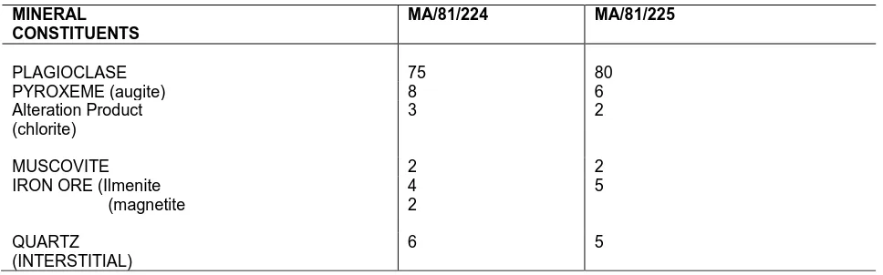
Table 4. Modal Analysis of Felsic Dolerite
MINERAL CONSTITUENTS
MA/81/224 MA/81/225
PLAGIOCLASE 75 80
PYROXEME (augite) 8 6
Alteration Product (chlorite)
3 2
MUSCOVITE 2 2
IRON ORE (Ilmenite (magnetite
4 2
5
QUARTZ (INTERSTITIAL)
6 5
far greater than 3:1, then, the limestone is a bioeparradite (using classification of limestone by Pettijohn, 1975). The discrete (or unbedded) tabular boulders of the limestone, the poor sorting, and the characteristic ubiquity of skeletal elements occurring as both altered hard parts and impressions, give the indication that the limestone was formed in situ (or authochthonous).
The features of this limestone are analogous to the biohermal facies of limestone described in Pettijohn (1975). Curaings and Shrook (1928, in Pettijohn 1975) defined bioherm as any domelike, mouldlike, lenslike or otherwise circumscribed mass, built exclusively or mainly by sedentary organisms, and enclosed in a normal rock of different lithologic character. The limestone unit of the mapped area is very fossiliferous, and completely sandwiched by a different lithologic unit - sandstone. This autochthonous limestone of the mapped area may therefore be regarded as a biohermal facies of limestone
Provenance and Paleo environmental Analysis of the Sedimentary Rock
In reconstructing the possible provenance for the sandstone unit of the mapped area, cognisance has been taken of the nature of quartz grains, feldspar content and
the heavy minerals present.
The quartz grains show seemingly deformed features which are evident on the satured contact outlines of the grains. They occur mostly as subangular to subrounded monocrystalline grains. The polycrystalline quartz grains show nucleation of angular grains that commonly display undulose extinction.
The sandstone contains some feldspars which are mainly plagioclase. Some of the feldspars have been altered. And some have irregular and sutured contact with neighbouring grains.
The micas present are markedly bent and elongate. Accessory magnetite, zircon and staurolite are present and occur in various shapes. The grain-to-grain relationship of the constituent detrital minerals gives evidence of textural immaturity.
The sphericity of the grains which is averagely elongate to intermediate shape suggest a near source area, thus, high sphericity could not be attained along a course of relatively short distance transport.
Table 5. Modal Analysis of Porphyritic Basalt
MINERAL CONSTITUENTS 80/1291 80/1294 80/1295
PLAGIOCLASE
(Laths and Phenocrysts)
50 10 15
PYROXENE (Crystals) (augite and pigeonite)
22 5 10
OLIVINE (Phenocrysts) 10 14 18 GROUNDMASS Plagioclase
Pyroxene Iron ore Glass
30 15 56 5 6
15 20 39 3 2 IRON ORE (Crystals)
(Magnetite)
8 3 13
ANALCITE 6 7 2
(VESICLES or Voids) 4 5 3
basement rocks lying in the north or south of the region of the mapped area.
The histogram plots of the sandstone samples yield bimodality. This shows a slight variation in the modes of the grain sizes. Bimodal distribution of grain sizes is a likely indicator of more than a lone source of the sediments (Pettijohn, 1975).
It is therefore probable that the source areas of the sandstone unit comprise both the basement rocks in the north of this region and the metamorphised rocks of the Bamenda Massif in the south of this region,
Paleoenvironmental Analysis
The paleoenvironment of deposition of the sandstone unit is considered with reference to stratigraphic signatures of the exposed sections and the sedimentary structures. The road-cut exposure of the sandstone shows sections that are characterized by ordered sequence of sandstone-siltstone-shale, followed by another cycle in the same trend of variation in lithologic facies. This gives rise to a repeated succession of sandstone-siltstone and shale (mostly weathered). The weathered shale layer in the sequence contains some dispersed calcareous nodules, which appear to be related to the lateritic soils on which they also occur. These calcareous nodules (caliche) are associated with continental lithotypes, primarily as the topmost member of typical fluvial (point-bar) sequences (Pettijohn, 1975).
The sandstone layers display intense ripples that are characterized by large troughs on which lies the siltstone layer, thus producing ripple bedding. Some sections show repeated alternation of sandstone and siltstone with absence of the shale (top layer). The mostly asymmetrical ripple marks may have been formed by current actions generated by a meandering river of fluvial
environment as movements proceeded towards the floodplain, (Reineck and Singh 1973).
The fining upward trend of the sandstone and its commonly rippled nature are probable signatures of fluvial (meandering river) environment.
The result of the histogram plots for the sandstone which gave a bimodal distribution of grain size may suggest a change in the mode of transportation of the sediments, from a somewhat high energy inertia suspension, to a viscous suspension mechanism (PettiJohn, 1975) This is a characteristic of fluvial (meandering river) environment. The fining upward motif of the exposed sections, and the mostly assyraetrical ripple marks of the sandstone (probably caused by current action) tend to suggest that the sandstone unit of the mapped area is of a fluvial (meandering river) environment.
The limestone unit appears to have a different paleoenvironment of deposition from that of the sandstone unit. This has been analyzed with reference to the presence of glauconite, fossils and preservation of their skeletal elements in the limestone.
The presence of glauconite suggests somewhat diagenetic changes due to subaqueous weathering which probably resulted in the replacement of feacal pellets by glauconites. This diagenetic activity is commonly favoured by slow sedimentation at shallow depths of water in a marine environment. It is likely that the slow nature of the sedimentation enhanced the preservation of the ubiquitous fossil shells and other skeletal fragments in the limestone.
environment. More also, the presence of subrounded grains of greenish glauconite might be associated to continual washing by wave action which also might be responsible for the appearance of pseudo-ripples on the surfaces of the tabular boulders of the limestone.
The formation of glauconite granules is mostly favoured under slightly reducing conditions. It is probable that the reducing conditions at the time resulted from the abundant organic remains, which provided a less oxidizing medium in a shallow marine environment (PettiJohn, 1975). The slightly reducing environment might have made the preservation of the copious fossil fragments somewhat efficient. The predominance of pelecypod shells is also an indication of shallow marine environment under normal salinity (Shrock and Twenhofel, 1953),
IGNEOUS ROCKS
Dolerite
This is the main intrusive rock of the mapped area. It covers an area of about 2Km x 1½km. This intrusive rock caused the baking of adjoining host sandstone. The highly baked portion (aureole) of the sandstone is jointed and the trends of the joints are mainly in two directions; 46azimuths and 318 azimuth. The dark coloured portion of the aureole is characterized by spheroidal weathering. The igneous rock is exposed at a distance of about half a kilometer north of this baked portion.
The southwestern side of this intrusive rock exposes some of the boulders that bear some 'aplitic stuff running almost vertically within them. These lenticular aplitic-stuff which are bounded by the main intermediate to dark coloured medium grained intrusive, are lighter coloured and fine-grains 1 in texture. This feature is observable in hand specimen. Some weathered samples have surfacial spots, brownish to rusty-red in colour. In thin section, the rock is holocrystalline and medium grained; as observed in samples MA/81/208, MA/81/209 and
MA/81/219.
The chief constituents of the rock are plagioclase and pyroxene (augite). Some secondary minerals present in the rock include chlorite and quartz. Iron ores are also present. (Tables 3-5)
The plagioclase minerals present in the rock are mostly subhedral crystal forms. Large rectangulates of plagioclase, measuring about 0.35 to 0.50mm in size are not scarce in the rock.
Most of the plagioclase crystals have been altered and display intense sericitization. The twinnings displayed by the crystals are more of carlsbad than the albite type. And the extinction angles indicate a range of plagioclase composition of An41 to An56 (mainly from calcic andesine
to laboradorite). Plagioclase minerals constitute about 45 to 65% of the rock.
The pyroxenes present in the rock are principally the clinopyroxenes (augite). They are mostly colourless to grey crystals. Some irregular dialage partings across euhedral crystals of the augite are common features exhibited in the rock (MA/81/208). Some idiomorphic
forms of augite display good prismatic cleavage and common lamellar twinning. Large plates of augite measure up to 0.52mm as the longest diameter. Augite forms about 26 to 34% of the rock.
Another type of pyroxene observed in the rock is hypersthene; which has been influenced and is related to the copious chloritization of the mafic minerals in the rock. It occurs in very trace amount, about 4% of the rock. The hypersthene crystals are idiomorphic and characteristically display pleochroism from green to brown colour.
Some of the pyroxene minerals have been altered into secondary minerals - Chlorite. These alteration products of pyroxene which constitute the secondary chlorites occur as irregular strings and patches of greenish colour; displaying significant greenish pleochroism.
They also occur as fibrous and scally materials. Some fibrous uralitic minerals are also associated with the chlorites.
CONCLUSION
The mapped area lies within the Benue trough of Nigeria. The elevation of the area is moderately high with the highest contour as 1000ft. The drainage pattern is dendritic, and a major water divide runs in a nearly north-south direction, separating the three drainage basins. The sediments in the area comprises sandstone and limestone units. The sandstone unit covers the greater portion of the mapped area. It consists of medium grained and fine grained sandstone, which constitute the Makurdi Formation within the mapped area. Exposed section of the Sandstone Unit shows a succession of sandstone, siltstone and shale cycles. The shale layer at the top contains some calcareous nodules. The exposed sections depict a fining upward sequence. The grain size distribution histograms and the stratigraphic signature of the Sandstone Unit suggest that it was deposited in a fluvial (meandering river) environment.
Evidence of igneous activity in the area is the emplacement of extrusive and intrusive rocks. The extrusive is a porphyritic basalt, which contains significant amount of olivine phenocrysts. The mineral assemblage suggests that the basalt is of alkaline affinity. The intrusive rocks are dolerite and felsic dolerite. They have almost an identical mineralogical assemblage, but for the predominance of lime-bearing plagioclase overall other in the area are likely of a basaltic magma origin.
There is evidence of the Santonian folding episode. It is recognized as regional folds in the Sandstone Unit, with fold axes trending Southwest-Northeast. Common sedimentary structures are ripple marks and cross-beddings. Groundwater potential in the area is of importance.
The mapped area contains sediments which suffered deformation and also encountered an igneous activity that took place in this part of Benue trough of Nigeria probably during the Cenozoic times.
REFERENCES
Burke, K., Dessauvagie, T. F. J., and Whitleman, A.J., (1970). Geological History of the Benue Valley and Adjacent areas. In African Geology (T.F.J. Dessauvagie and A.J. Whiteman, Eds). Univ. of Ibadan Press, Nigeria. Carmichael, I.S.E., Turner, F.J. and Verhoogen, J., (1974). Igneous Petrology. McGraw-Hill Book Co. New York.
Cartchley, C.R., Jones, G.P., (1965). An Interpretation of the Geology and Gravity anomalies of the Benue Valley, Nigeria. British Overseas Geol. Surveys, Geophysical paper No.1.
Deer, W.A., Howie, R.A. and Zussman, J., (1978). An Introduction to the Rock-forming minerals. The English Lang. Book Soc. and Longman.
Farrrington, J.L., (1952). A preliminary description of the Nigeria Lead-Zinic Field. Economic Geology, Vol. 47, p. 583-608.
Folk, R.L., (1968). Petrology of Sedimentary Rocks. Austin, Texas, Hemphills.
Folk, R.L. and Ward, W.C., 1957. Brazos River bari A study in the significance of the grain size parameters. Jour. Sed. Petrol. Vol.27 p.36
Harker, D.K., (1972). Petrology for students. An introduction to the study of rocks under the microscope. Cambridge Univ. Press.
Hoque, M., (1977). Petrograpic Differentiation of Techonically Controlled Cretaceous Sedimentary Cycles, Southeastern Nigeria. Sed. Geol. Vol. 17, p. 235-245. Kerr, P.F., 1959. Optical Mineralogy. McGraw-Hill Book Co. New York.
Kogbe, C.A., (1976). Paleogeographic History of Nigeria from Albian Times. In Geology of Nigeria (C.A. kogbe, Ed.). Elizabethan Pub. Co. Lagos, Nigeria.
Kogbe, C.A., Tokarski, A, Osijuk, D. and Wonzy, D.E., (1978). Geology of the Makurdi Sheet 251 in the Middle Benue Valley, Nigeria. Occasional Pub. No.5 Dept. of Geol., Ahmadu Bello Univ. Zaria, Nigeria.
Moorhouse, W.W. (1959). The study of rocks in thin section. Harper and Row Pub. New York and Evanston. Murat, R.C., (1970). Stratigraphic and paleogeography of the Cretaceous and Lower Tertiary in Southern Nigeria In
African Geology (T.F.J. Dessauvagie and A.J. Whiteman, Eds.) Univ. of Ibadan Press, Nigeria.
Nockolds, S.R., O ‘B Knoxx, R.W. and Chinner, G.A., (1978). Petrology for students. Cambridge Univ. Press, Cambridge, London, New York, Melbourne.
Offodile, M.E., (1976). A Review of the Cretaceous of the Benue Valley. In Geology of Nigeria ( C.A. Kogbe, Ed.), Elzabethan Publ. Co. Lagos, Nigeria.
Pettijohn, F.J., (1975). Sedimentary Rocks. Harper and Row Publishers, New York.
Potter, P.E. and Pettijohn, F.J., (1963). Paleocurrents and Basin Analysis. Berlin, Springer-Verlag.
Reineck, H. and Singh, I.B., (1973). Depositional Environments. Spinger-Verlag, Berlin.
Reyment, R.A., (1965). Aspects of Geology of Nigeria. Univ. of Ibadan Press, Ibadan, Nigeria.
Shrock, R.R. and Twenhofel, W.H., (1953). Principles of Invertebrate Paleontology.McGraw-Hill Book Co., New York, Toronto, London.
Wright, J.B., (1976a). Volcanic rocks in Nigeria. In
Geology of Nigeria (C.A. Kogbe, Ed). Elizabetan Publ. Co. Lagos, Nigeria.
Accepted 05 May, 2017.
Citation: Madu AJC, Ozibo BN (2017). Geology of parts of Gboko and Makurdi Local Government Areas, Benue State, Nigeria. International Journal Geology and Mining 3(1): 071-080.