REVIEW ARTICLE
GEOSPATIAL DATA INFRASTRUCTURES MODEL FOR LAND-USE IN DEVELOPING COUNTRIES:
THE NIGERIA SCENARIO
1,2
*Chinonye C. Onah,
3Chukwudi Nwaogu,
4Paulina Nakashole,
5Modupeola Olawoyin
and
3Vilém Pechanec
1
Institute for Geoinformatics, University of Muenster, Germany
2
Instituto Superior de Estatística e Gestão de Informação, Universidade Nova de Lisboa, Portugal
3
Department of Geoinformatics, Palacký University Olomouc, 771 46 Olomouc, Czech Republic
4
Department of Geography, Palacký University Olomouc, 771 46 Olomouc, Czech Republic
5
Department of Educational Management and Economics, University of Ibadan, Nigeria
ARTICLE INFO ABSTRACT
This research explores the basics of SDI, and investigates the National SDI of different countries. Further, the research analyses SDI implementation in developing country with specific reference to the National Geospatial Data Infrastructure (NGDI) of Nigeria. The research assesses the status and the milestones of NGDI implementation using key SDI components as assessment variables. These components were grouped into four classes: Policy and Legal Issues, Technical, Funding and People. A questionnaire survey via email was conducted on the stakeholders and users of geoinformation in Nigeria. From the analysis, the NGDI has an advantage of having a national policy backing its implementation and the establishment of the coordinating body. However, the lack of SDI directive and funding are major hurdles in the implementation of the NGDI making it lack behind most of the selected case study countries in other key components. Nigeria is also found to be applying a Mixed Model of NSDI implementation as both product model and process model are evident in the NGDI. In the real sense of access network and data sharing, NGDI is yet to be operational, though the project is going on.
INTRODUCTION
The term Spatial Data Infrastructures (SDI) is often used to denote the relevant base collection of technologies, policies and institutional arrangements that facilitate the availability of and access to spatial data. The SDI provides a basis for spatial data discovery, evaluation, and application for users and providers within all levels of government, the commercial sector, the non-profit sector, academia and by citizens in general(SDI-Africa, 2004). SDI is now playing a much broader role in a modern society. The concept involves a complex digital environment including a wide range of spatial databases and is concerned with standards, institutional structures and technologies including the World Wide Web (WWW). SDI is now moving to underpin an information society and enable a
society to be spatially enabled (Williamson et al.,
2006a.Rajabifard et al. 2003). Many countries worldwide are
engaged in SDI development, which involves the development of geospatial services that support public service delivery.
*Corresponding author: Chinonye C. Onah,
Institute for Geoinformatics, University of Muenster, Germany.
This development ranges from local to state/provincial, national and regional levels, to a global level.
Components of SDI
The Australia New Zealand Land Information Council (ANZLIC 1998), identifies institutional framework, technical standards, fundamental datasets, and clearing house networks as the core components. The institutional framework defines the policy and administrative arrangements for building, maintaining, accessing and applying the standards and datasets. The technical standards define the technical characteristics of the fundamental datasets. The fundamental datasets are produced within the institutional framework and fully comply with the technical standards. The clearinghouse network is how the fundamental datasets are made accessible to the community, in accordance with policy determined within the institutional framework, and to agreed technical standards. In addition to these basic components, there is the people component which includes the spatial data users, suppliers and any value-adding agents in between, who interact to drive the
development of SDI (Williamson et al., 2003a).
Article History:
Received 27th October, 2016
Received in revised form
25th November, 2016
Accepted 06th December, 2016
Published online 30th January, 2017
www.ijramr.com
International Journal of Recent Advances in Multidisciplinary Research
Vol. 04, Issue 01, pp.2151-2162, January, 2017
Keywords:
Clearinghouse, Metadata,
National Geospatial Data Infrastructure (NGDI),
Data: Data sets, which may be used for many different purposes and in many different applications, are often referred to as base data, core data, fundamental data or reference data. These datasets are widely needed for a variety of purposes and by many agencies. The other types of datasets are known as thematic datasets which are derived from the fundamental
datasets (SDI Africa, 2004). Metadata: Metadata is a summary
document about the dataset, including the geographic area that the dataset covers, the custodian, who to contact to obtain a copy of the dataset and other useful information that helps people decide if the dataset is useful for their purpose. A geospatial metadata record includes core library catalog elements such as Title, Abstract, and Publication Data; geographic elements such as Geographic Extent and Projection Information; and database elements such as Attribute Label Definitions and Attribute Domain Values.
Standards: Effective use and sharing of spatial information requires that it adheres to known and accepted standards. Standards facilitate the use of a wider range of data. Development of formal standards is a consultative process through national standard bodies through international standard organizations. Spatial data are standardized in terms of geographic referencing, the data content, the resolution, and metadata (SDI Africa, 2004). Some international standard organization for geographic information are ISO TC211 (de-jure) standards, and de facto specifications from organizations such as OGC (Open Geospatial Consortium), Organization for the Advancement of Structured Information Standards
(OASIS) and W3C (Gould et al., 2008). There is close
relationship between OGC and ISO TC211, resulting in an
effective joint development of certain standards. Access
Network: Gould et al (2008) state that “Although SDI are primarily institutional collaboration frameworks, they also define and guide implementation of heterogeneous distributed information systems, consisting of four main software components linked via Internet. These components are: 1) metadata editors and associated catalogue services, 2) spatial data content repositories, 3) client applications for user search and access to spatial data, and 4) middleware or intermediate geoprocessing services which assist the user in finding and in transforming spatial data for use at the client side application” (Fig. 1).
People and Partnership: This component includes the spatial data users and suppliers and any value-adding agents in between, who interact to drive the development of the SDI. For this reason, the formation of cross jurisdictional partnerships has been the foundation of SDI initiatives supported to date. People are the key to transaction processing and decision-making. All decisions require data and as data becomes more volatile human issues of data sharing, security, accuracy and access forge the need for more defined relationships between people and data. The rights, restrictions and responsibilities influencing the relationship of people to data become increasingly complex, through compelling and often competing issues of social, environmental and economic management. Facilitating the role of people and data in governance that appropriately supports decision-making and sustainable development objectives is central to the concept of SDI.
Policies and Institutional Arrangements: The institutional framework defines the policy and administrative arrangements for building, maintaining, accessing, and applying the standards and datasets (ANZLIC 1998). Policies and Institutional Arrangements define other components of SDI such as governance, data privacy and security, data sharing, and cost recovery (Federal Geographic Data Committee, 2008).It is the policies and organizational components that make it possible for the realization of aims and objective of SDI. Even when data and other components are in place, without enabling policies, and institutional arrangements, coordination, cooperation and sharing will not be achieved. The dynamic nature and relationships of this SDI Components has been illustrated (Fig. 2).
History of SDI
Like other forms of infrastructures SDI has development history, ‘with every country at different development continuum’ (Nebert, D., 2006; Masser, 2003).The first generation of SDI development emerged in the mid-1980s when the USA and Australia, for example, started to develop the data access relationships, which became the precursor to the development of NSDI initiatives. Now, countries developing SDI on any jurisdictional level had only very limited ideas and knowledge about different dimensions and issues of the SDI
Fig.1:High-level SDI architecture, taken from the FGDC-NASA Geospatial Interoperability Reference Model (GIRM), [FGDC, 2008]
concept, and rather less experience of such development. Within this generation, each country designed and developed SDI based on their specific requirements and priorities and nationally specific characteristics. The ultimate objectives of the SDI initiatives in this generation as summarized by Masser, (1999) were to promote economic development, to stimulate better government and to foster environmental sustainability. A significant milestone overcome by the first generation, for whom there were few experiences and existing SDI developments from which to learn, was the documentation of researchers’ and practitioners’ experiences and status reports on their SDI initiatives and as part of that report on their clearinghouse activities which facilitated their SDI initiatives.
Levels of SDI
SDI can be developed at corporate level, local level, state level, national level (NSDI), regional level and global level. Many countries are developing SDI at different levels ranging from local to state/provincial, national and regional levels, to a global level. The objectives of these initiatives are to promote economic development, to stimulate better government and to foster environmental sustainability (Masser, 1996).
Fig. 3. SDI Hierarchy, Relationships among different levels of
SDI and levels of Planning (Adapted [Rajabifard et al., 2003])
Rajabifard et al (2000) developed a model of SDI hierarchy
that includes SDI developed at different political-administrative levels.
Based on this model, the SDI hierarchy creates an environment, in which decisionmakers working at any level can draw on data from other levels, depending on the themes, scales, currency and coverage of the data needed (Fig.3). The doubleended arrow in this figure represents the continuum of the relationship between different levels of detail for the data to be used at the different levels of planning corresponding to the hierarchy of SDI.
SDI Development Models
Rajabifard et al (2003), identified two models namely
product-based and process-product-based that can be identified in contemporary SDI development, as illustrated in Fig.4. The product-based model (Fig. 4A), represents the main aim of an SDI initiative being to link existing and upcoming databases of the respective political/administrative levels of the community. The process-based model, (Fig. 4B) presents the main aim of an SDI initiative as defining a framework to facilitate the management of information assets. In other words, the objectives behind the design of an SDI, by any coordinating agency, are to provide better communication channels for the community for sharing and using data assets, instead of aiming toward the linkage of available databases.
Fig. 4.Product and Process based models for
Table 1. An abridged comparative analysis of selected countries with Nigeria (NGDI)
Developed World Developing World
SDI
COMPONENT
SPECIFIC
VARIABLES Australia USA Netherlands South Africa Colombia Indonesia Nigeria
Data Core datasets Data Format Updating Resolution Defined Digital Yes Different Defined Digital Yes Different
Defined Digital Yes Different Defined Digital Yes Different Defined Digital Yes Different Defined Digital Yes Different
Defined Analogue Yes Two Scales Access Network Metadata Access MechanismNetwork Architecture Clearinghouse Yes Yes 25distributed node Not well defined
Yes Yes Distributed dataproviders Yes Yes Yes Web based architecture Yes Yes Yes Web based with several nodes Yes Yes Yes LAN/Internet ininstitutions Yes Yes Yes Network Gateway No No Central Server Standards Data Transfer Transfer Standard Interoperability Arranged ISO 19115,OGC Yes Arranged FGDC,ISO TC211,OGC Yes Arranged EGII,ISOT C211 Yes No Data FGDC,ISO, SDI ACT No Arranged ISO TC 211 FGDC No
Arranged FGDC No
Not Arranged SON,ISO Standards
No
Policy
Coordinating Body SDI Directive Data Access and Pricing
Yes Yes Yes Yes Yes Yes Yes Yes Yes Yes Yes Yes No No No Yes Yes Yes Yes No Yes Institutional Arrangements Coordinating Body Participating Agency Working Groups Present Yes No Present Yes Yes Present Yes Yes Present No Yes Present Yes Yes Present Yes NotDefined Present Yes No
Table 2. Composition of NGDI Committee [Agbaje and Akinyede, 2005]
Number Representation Remark
2 NASRDA. Lead Agency.
2 Universities. Universities selected in rotation.
2 Poly/Monotechnics. Poly/Monotechnics selected in rotation.
6 Six Geopolitical zones-States nodal agencies. States within each geopolitical zone selected in rotation.
4 Private Sector,Inter-governmental & Non-governmental organizations. GI related sectors.
11 Federal Ministries/Agencies. >85% of the Federal Ministries/Agencies such as Science & Tech, Info&comm., Environment, etc.
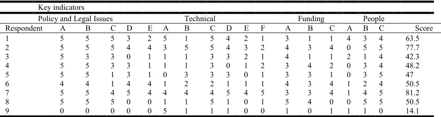
Table 3. Result of Questionnaire Survey converted to scores
Key indicators
Policy and Legal Issues Technical Funding People
Respondent A B C D E A B C D E F A B C A B C Score
1 5 5 5 3 2 5 1 5 4 2 1 3 1 1 4 3 4 63.5
2 5 5 5 4 4 3 5 5 4 3 2 4 3 4 0 5 5 77.7
3 5 3 3 0 1 1 1 3 3 2 1 4 1 1 2 1 4 42.3
4 5 5 3 3 1 1 1 3 0 1 2 3 4 2 0 3 4 48.2
5 5 5 1 3 1 0 3 3 3 0 1 3 3 1 0 3 5 47
6 4 4 1 4 4 1 2 2 1 1 1 4 3 4 1 2 4 50.5
7 5 5 4 5 4 4 4 4 5 4 5 3 3 4 1 4 5 81.2
8 5 5 5 0 0 1 1 5 1 0 1 5 4 0 0 5 5 50.5
9 0 0 0 0 0 5 1 1 1 0 0 1 0 1 1 1 0 14.1
Review of SDI Assessment: Due to their complex, dynamic
and evolutionary nature SDI assessments are difficult(Gruset
al, 2007). SDI have similar characteristics with Complex
Adaptive Systems (CAS) in that they are open systems in which different elements interact dynamically to exchange information and where the system has emergent properties that cannot be understood by reference to the component partsMarion, (2003)“As SDI can be treated as a Complex Adaptive System, the assessment should include strategies for evaluating those kinds of systems. One strategy is to use
multiple assessment approaches and methods”, (Gruset al,
2007). Some of the SDI assessments that have been done using the multi-view approach Cut across countries (Table 1) and these included:
Assessing an SDI Readiness Index, (Delgado-Fernandez
et al., 2005);
World Status of NSDI Clearinghouses, (Crompvoets
and Bregt, 2003);
INSPIRE State of play: Generic approach to assess the
status of NSDI, (Vandenbroucke and Janssen, 2008);
A Review of the Status of Spatial Data Infrastructures
Implementation in Africa, (Makanga and Smit, 2008).
However, this research will focus on the development of National SDI (NSDI) as it applies to developing nations using National Geospatial Data Infrastructures of Nigeria as a case study. The SDI concept continues to evolve as it becomes a
core infrastructure supporting economic development,
environmental management and social stability in developed and developing countries. Due to its dynamic and complex nature, it is still a fuzzy concept to many, with practitioners, researchers and governments adopting different perspectives
depending on their needs and circumstances (Williamson et al,
2003a).Building SDI is a complex task, not just because of the evolving nature of the SDI concept, but as much because of the social, political, cultural and technological context to which
such development must respond(Williamson et al, 2003b). The
reality is that every country is at a different point in ‘SDI development continuum’, with the developed world at the front end of the pole, and the developing countries lagging far behind. In addition, many developing countries still have fragmented institutional arrangements in the spatial data and land information area. It is not uncommon to find a range of different government departments, often in different ministries, responsible for different aspects of the management of the spatial data. It is not surprising that moves to establish SDI under these circumstances are problematic at best or
non-Fig. 5. NGDI Organizational Framework (National Geoinformation Policy, September, 2003)
existent at worst (Williamson et al, 2003b). Current understanding of SDI has seen the development of SDI models that have not met user needs as expected, currently providing mainly an ability to access and retrieve spatial data. Hence the concept of an SDI needs to progress so that it allows more than just the ability to access spatial information. It needs to become an entity that is enhanced so that it is possible to share data, business goals, strategies, processes, operations and value-added products and services in order to support a spatially enabled government (Rajabifard and Binns 2005). Some studies have been carried out on the initiatives and models of SDI in different parts of the world such as documented in Nebert, (
2006) for USA, (Rajabifardet al., 2006) for Australia, GSDI
Cookbook, Version 2, (2004) Columbia, (Crompvoets et al,
2004). Worldwide development of national SDI clearing house. However, a systematic study of the development of national SDI in developing countries with a view to assessing the success, challenges and problem which in turn will help in developing a model for SDI development is lacking. The major objective of this thesis is to assess the status and milestones of the implementation of the Nigerian Geospatial Data Infrastructures and compare it with selected NSDI. To achieve this objective, the following specific objectives should be achieved: 1.) To examine the institutional arrangements in place to facilitate GI sharing; 2.) To examine the issue of data access, data security, and partnerships among producers and users; 3.) To examine progress made so far in the implementation of NGDI; 4.) To examine the NGDI implementation in the light of some selected NSDI from other parts of the world. It was hypothesized that (i)The current NGDI is effective and developing per the National Geoinformation Policy(H1) and (ii)The NGDI experience is not different from the NSDI of the selected countries (H2). Within this contest, we addressed the following questions: 1.) Who are the major stakeholders in NGDI? 2.) What institutional arrangement is in place for the development of NGDI? 3.) What are the problems and challenges facing the development of NGDI? 4.) What lessons can be learnt from NGDI experience? 5.) Is NGDI development in line with the selected NSDI trends?
MATERIALS AND METHODS
Study area
Nigeria, officially named the Federal Republic of Nigeria is a federal constitutional republic comprising thirty-six states and one Federal Capital Territory. There are 774 local government areas in the country. The country is in West Africa and shares land borders with the Republic of Benin in the West, Chad and Cameroon in the East, and Niger in the North. Its coast lies on the Gulf of Guinea, part of the Atlantic Ocean, in the south.
The capital city is Abuja (9010'N and 7010'E). It has a surface
area of 923,768km2 (Figure 8). It has a population estimate of
148 million people comprising about 250 ethnic groups. Nigeria has a varied landscape: from the Obudu Hills in the southeast through the beaches in the south, the rainforest, the Lagos estuary and savanna in the middle and southwest of the country and the Sahel to the encroaching Sahara Desert in the extreme north. Nigeria is also an important center for bio- diversity. Nigeria’s main rivers are the Niger, the Benue which converge and empty out in the Niger Delta, one of the world's largest river deltas.
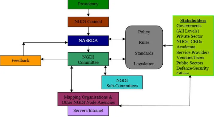
As a federal state, it has three-tiers of government: the federal, the state, and the local government, all coordinated by the ministries, agencies and parastatals. The National Geospatial Data Infrastructures of Nigeria (NGDI) is an NSDI initiative that among other objectives is to promote the production, dissemination and use of geospatial information for poverty alleviation, food security, job creation, improvement of quality of life, good governance, education and health care delivery, water resources management, environmental and disaster management, transportation, tourism, communications, gender mainstreaming, national defense and security, economic planning and natural resources management. Other objectives include the discovery, harmonization and standardization of geospatial data production and management, and the provision of a platform for data sharing thereby eliminating data duplication and conserving cost and time spent in producing already available data(Agbajeand Akinyede2005). An efficient functioning NGDI and the associated GI Policy is regarded as vital requirements for sustainable national development. This chapter focuses on the National Geospatial Data Infrastructure (NGDI) of Nigeria: the development of the NGDI from policy formulation, stakeholders, organization, problems, challenges and prospects as documented in the literature will be presented.
NGDI & National Geoinformation Policy
The Driving forces: Due to the increasing awareness of the use of GI for decision-making over the past years, coupled with the expected availability of primary dataset from the Nigerian Satellite, the country has realized the need to adopt policies for promoting greater awareness and public access to standard and coordinated geo-spatial data production, management and dissemination by all sectoral institutions and the need for the establishment of a Geospatial Data Clearinghouse at various levels in the country (local, state and federal) and linkages with the private sectors. In September, 2003, the final draft of Nigerian Geoinformation Policy was formulated by the Federal Ministry of Science and Technology, Abuja. The vision of the GI Policy is to enhance optimal use of Geospatial Information as a critical resource in all phases of sustainable national development for the alleviation of poverty and improvement of quality of life of the people of Nigeria by establishing and maintaining an NGDI, (National Geoinformation Policy). The references to this section unless otherwise stated refer to National Geoinformation Policy. The NGDI Committee A 27- member committee was inaugurated by the Honorable Minister of Science and Technology. The Committee members are drawn from the academia, public organizations, and GI related NGOs, and private sectors. The Committee members are well spread in terms of stakeholders and geographical distribution across the country to enforce partnership and create an enabling environment for data access and dissemination. The
National Space Research and Development Agency
(NASRDA), is the lead Agency while other GI Producers shall be NGDI node agencies. The composition of the committee is shown in Table 2. The functions of the NGDI Committee are well documented in (Agbajeand Akinyede2005). Institutional
Arrangements. The NGDI Project in Nigeria has
administrative/organizational framework that is
multidisciplinary, interagency and inter-sectoral network of institutions coordinated by the lead Agency, National Space Research and Development Agency, (Fig. 5).
The Fundamental Datasets: The following datasets shall constitute the fundamental datasets for the NGDI: Geodetic control database, topographic database/DEM, digital imagery and image maps, administrative boundaries’ data, cadastral databases, transportation data, hydrographic data, land use/land cover data, geological database, and demographic database. Thematic Datasets on the other hand are derivative datasets
from fundamental datasets. Access Network: National GI
Policy has a comprehensive statement on metadata of which the main ideas can be summarized as the following, “Every geospatial data producer shall provide metadata for each of its data holdings; the metadata of any dataset shall be updated whenever the dataset is updated; the metadata produced shall conform to the national standard; the metadata structure shall strive to conform to the ISO metadata standard (ISO TC211); metadata shall accompany the dissemination of all geospatial data. The importance of metadata cannot be overemphasized, as it gives descriptive information about the available data. The apex Clearinghouse shall be at NASRDA as coordinating agency with Clearinghouse nodes at other geospatial data producing agencies (Fig.6); there shall be free access under a legal framework (protection of copyright) to other community and private datasets, and each geospatial data-producing agency shall establish a metadata database server as a NGDI node, linked to the apex Clearinghouse. The availability of clearinghouse catalogue is paramount in any NSDI, and can be used as a yardstick in measuring the extent to which the NSDI is advanced.
Data sampling
A questionnaire survey was carried out to assess systematically the development and status of National Geospatial Data Infrastructure of Nigeria regarding the SDI components. The survey covered most aspect of NGDI components including policy, organizational and legal issues, data access mechanism, technical standards (metadata and clearinghouse) prices for data, people (including partnership). Considering the complex, dynamic and constantly evolving nature of NGDI, a multi-view
assessment framework is used, (Grus et al., 2007; Makanga
and Smit, 2008). These NGDI components are grouped into four headings: Policy and Legal Issues, Technical, Funding and People. The data collected from the questionnaire was analyzed. Further, a comparative analysis of selected NSDI across the world was made vis-à-vis NGDI (Table 1). A
multi-view SDI assessment framework as proposed by Grus et al
(2007), was adopted for this study. The main idea of multi-view SDI Assessment Framework is that it acknowledges the multi-faceted character of SDI, and assesses the SDI from different viewpoints. Four viewpoints were established and these are: 1) Policy and Legal issues 2) Technical issues 3) Funding 4) People. A set of seventeen (17) more specific indicators were formulated which are based on the four viewpoints.
Questionnaire Survey A questionnaire is a commonly used method of collecting information from respondents. It is convenient for collecting data over large geographical distances and can be very useful in exposing the reality of the situation and identifying current problems. The respondents were chosen from the various stakeholders of NGDI: the coordinating institution, the nodal agencies, committee members, users, government, private organizations, academia and NGOs.
The purpose of the questionnaire is (i) To examine the different components and sub-components of NGDI; (ii) To assess the level of implementation of the NGDI Project; (iii) To identify some problems encountered in the implementation project. The main points of reference for the questionnaire are the viewpoints identified and broken down into a set of seventeen indicators. The Information was compiled to establish scores against the indicators (Table 3). The letters represent questions on the sub-indicator/view points. For example, under Policy and Legal issues: A= existing National SDI coordinating body, B= good Policy establishing NGDI coordinating Agency, C= available NGDI Champion at the highest political level, D= established legal framework governing spatial data creation, E= developed legal framework governing spatial data pricing; Under Technical: A= Data access mechanism, B= Technical standards, C= data interoperabilitry, D= Metadata, E= data Standard, F=Clearing house; Funding source:A= National Budget, B= Self-sustenance, C= Pricing policy; For People: A= Partnership, B= Stakeholders, C= Skilled Personnel. For the numbers:5=Absolutely True, 4=Fairly True, 3= Slightly True, 2=Slightly False, 1= Absolutely False, 0=no idea/not sure/no response. For all possible indicators, there were six possible responses namely: Absolutely True, Fairly True, Slightly True, Slightly False, Absolutely False, Not Sure.
In addition to these close ended questions, a provision was made for open ended comment at the end of the questionnaire. For purpose of Ranking: Absolutely False = 1, Slightly False = 2, Slightly True = 3, Fairly True = 4, Absolutely True = 5. A total of 20 questionnaires were sent out for this survey. The questionnaires were sent to the stakeholders and users of geoinformation in Nigeria, both in government and private sectors; producers and users; within the capital city and upcountry; NGOs and academia. There were significant limitations observed during the data collection process between October, and November 2008. One of them was hesitance on the part of the government officials to respond on questions which involve government or which they perceive should be answered by their senior officers. Some higher officers meanwhile delegated their junior officers to respond to the questionnaire. Attempt to overcome this problem was made by removing personal information section from the questionnaire and resending them. Response increased by more than 30%. The other major problem was how to reach the potential respondents. Some of the potential respondents were not reached because their email addresses were no longer functioning.
RESULTS AND DISCUSSION
Analysis by Respondents
Fig. 7. Analysis by Sector
56% of the respondents are from the government sector, 33% from the private sector and 11% from the academia (Fig.7). NGDI is a government project; therefore, the participants are mostly people working in public sector. The committee members are mostly drawn from government establishments. Even though the GI policy makes room for public-private participation, the reality is that people that constitute the geospatial data developers, disseminators and users fall within government sector.
Fig. 8. Analysis by Location
67% of respondents are working in Abuja, the Federal Capital Territory of Nigeria, while 33% of the respondents are outside (up country) Abuja (Fig.8). Nigeria as a federal state has the headquarters, including NASRDA of all the ministries in the capital city, Abuja. Most government decisions are taken in the headquarters of the ministries. Though the questionnaire was sent nationwide, the subjects at Abuja seems to be more informed of NGDI, as most people from up-country did not respond.
Fig. 9. Analysis by Position Rank
The respondents consist of directors from government (33%), university professor (11%), senior civil servants (22%), and field professionals (33%) (Fig.9).This is an equitable distribution of respondents.
Fig.10. Analysis by Scores
The scores of each respondent are added up and normalized to 100% to give what we can call here NGDI Score of the respondent. The NGDI Score herein after known as the Score of the respondent represents the assessment value of the NGDI from the perspective of the respondent. In this study, it is assumed that each specific indicator has equal weight and therefore the summation of the scores will give an indication of the status of NGDI from the point of view of the respondent. The score ranges from 14.1% to 81.2%.and are divided into three classes: 14.1-42.1, 42.3-50.5, and 50.6-81.2. 14.1-42.2 (Fig.10): There is only one respondent whose score is in this class, a government director by rank, from up country. This suggests that the NGDI awareness is very limited in some parts of Nigeria outside the capital city. 42.3-50.5: This is both the modal class and the class that contains the median. Five respondents are in this class. In qualitative terms, respondents in this class gave a medium score in the overall assessment of NGDI status. Respondents here are distributed across government (geospatial dataset committee), private sector and academia. 50.6-81.2: The respondents in this class gave a high score to NGDI project. Three respondents are within this group. Two is from government (a representative of the project manager himself, and a committee member, geospatial datasets) and one from the private sector. It is obvious that these respondents are close to the project. The private sector here may be doing some contract in NGDI implementation.
Analysis by Indicators
Here an analysis of the results based on responses to each specific indicator is made. Table 4 summarizes how research subjects responded to each specific indicator. Each alphabet on the left column of the table represents a specific indicator (question in the questionnaire), while the figures inside the table represent the number of respondents that scored the NGDI a particular ranking. For instance, in specific indicator, A in Policy and Legal Issues component class, seven (7) respondents answered ‘Absolutely True’ in the questionnaire, while 1 (one) respondent each answered ‘Fairly True’ and ‘Not Sure’ respectively. This means that there is certainly the presence of the variable which specific indicator A is assessing.n Analysis of the result of questionnaire on the Policy and Legal Issues component class indicate that NGDI started well on this component (Fig.11).
Fig. 11. Policy and Legal Issues Indicator Class
There is almost unanimous agreement on the presence of national SDI coordinating body, and the presence of a policy establishing the coordinating agency. The response to the specific question on the NGDI Champion at highest political level was scored well. Here we mean a politician in the National Assembly pioneering and pushing for SDI awareness, funding and law. The civilian administration of 1999-2003 gave priority to Nigerian Space Mission which put NigeriaSat-1 into space and established NGDI coordinating agency. There is a new administration now, and hitherto emphasis on earth observation satellite is now shifted to telecommunication satellite NigComSat-1 that was launched in China in 2007.On the legal framework for spatial data creation and pricing, the respondents scored it poorly. There is policy framework guiding these activities but they are not signed into law yet.
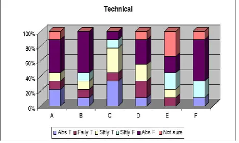
Fig. 12. Technical Indicator Class
The technical aspect of any NSDI is the pivot on which its data sharing rotates. With respect to the NGDI access network, the intention is to put in place a high-speed and high bandwidth backbone carrier as the main gateway and master server and implement a database server at each mode. This is not available yet. In addition, telecommunication facilities and electricity power supply are still problematic in Nigeria. The bad shape of access network facilities notwithstanding, the analysis from the questionnaire responses indicates good accessibility to geospatial data through CDs (Fig.12). There is equally good effort towards interagency coordination of spatial data creation. Metadata capturing is also scored highly by the respondents. The responses however show lack of standardization in spatial data creation and absence of apex clearinghouse. Data is acquired and stored for own use and applications, with the difficulties of unnecessary overlaps and duplication, lack of accessibility, and varying standards and formats Funding is earmarked as major problem in the NGDI implementation.
Fig. 13. Funding Indicator Class
The responses of the subjects to this component class are not very encouraging (Fig.13). The major source of income for NGDI implementation is from national budget. There is effort towards fund generation from access charges and data sales, but this is not viable yet. In addition,Nigeria has not received international grant. Even there is no agreement on the existence of policy for spatial data pricing.
Fig. 14. People Indicator Class
There is sound organizational framework for the NGDI implementation. The NGDI Committee, the Sub-committees and working groups as being highlighted. Responses from the questionnaire however indicate there is not enough public-private participation (Fig14). The major stakeholders, predominantly government however participate in the implementation. On the specific component of skilled personnel, there is capacity working group in place, and there is reasonable number of skilled personnel to man the NGDI implementation. Though availability of skilled personnel especially in technical areas is still a problem.
Research Question 1: Who are the major stakeholders in NGDI? The result revealed that the major stakeholders of NGDI are Government (federal, state, local and their ministries and agencies), Academic and Research community, Service
Providers/Vendors and End-Users, Non-Governmental
Organizations, Private Organizations, Public Sector Agencies, Defense and Security.
Below the NGDI Council is NASRDA, which is the lead agency and the secretariat of the NGDI Committee inaugurated in 2003 to oversee the implementation of the NGDI. NASRDA has commendable institutional framework for NGDI implementation. There is in operation, an Earth Observation Satellite (NigeriaSat-1) in orbit which is in constellation with other four satellites from China, UK, Algeria, and Turkey. There is also state of the art ground receiving stations in Abuja that processes and manages images that are captured by Nigeria Sat-1. There is a Centre for Remote Sensing in Jos which is another agency under NASRDA that facilitates image processing from Nigeria Sat-1.This is a significant step towards mapping and geoinformation in general. Agreement for the design, building and launch of NigeriaSat-2 which will replace Nigeria Sat 1 has been signed. It is expected to go into orbit in 2009. In addition, there are six NGDI Sub-Committee whose functions virtually cover every aspect (components) of NGDI. Each of this committee is empowered to establish Working Groups as it considers necessary. There is a Policy establishing the lead agency (NASRDA), but what is lacking now is SDI Directive. In other words, NGDI Policy is yet to be signed into law. In concept, all the stakeholders mentioned in Research Question 1 are to partake in production, dissemination and utilization of geospatial data within a set of policy, rules, standards, and legislation from NASRDA.
Research Question 3: What are the problems and challenges facing the development of NGDI? The policy statement of the NGDI is impressive. However, the implementation of the NGDI is facing a lot of challenges: these challenges are outlined in the comments made by respondents. They include: Funding: Since the inauguration in 2003, funding has been a problem for NGDI implementation. It is just of recent that a foreign company was engaged to partake in implementation of development of clearinghouse at NASRDA. Lack of SDI Directive: The GI policy is yet to be passed into law. This makes it difficult for NASRDA to implement standards on data acquisition and sharing. Lack of data sharing: Individual data acquisition is still going on among geospatial data creators, thus efforts are duplicated in data creation, and data sharing is still lacking.
Nigeria is a land of contrast with diverse geographical, social, cultural features. And each section of the country has its own peculiar data requirement and often reluctant to share their data without anyone unless they have something to benefit. SDI directive will minimize this individualistic attitude towards data collection and sharing. Capacity building and Awareness: Though there is reasonable number of skilled personnel in the field of geoinformation, much effort is still needed in this area, as NSDI is dynamic creating the need for training and retraining of professionals. Awareness is another problem faced by NGDI implementation. Up till today, Nigerian populace is still asking the justification of Nigeria Space Mission and the launch of Nigeria Sat-1. Some awareness seminar has been done by NASRDA in Abuja, but it is not enough. Nigerian citizens still see NigComSat-1 which went into orbit in 2007 as more beneficial to their lives.
Research Question 4: What lessons can be learnt from NGDI experience? NGDI can be regarded as a second generation NSDI. It started when some countries have gone far in the implementation of their NSDI.
Nigeria had the advantage of professionals from USA, the Netherlands, and the UK to attend the first stakeholder and user’s workshop in February 2003 which charted the way for NGDI implementation. Nigeria’s experience is worthy especially to the developing countries that are yet to define
their SDI structure and direction (Rajabifard et al., 2002). The
study of NGDI revealed that it is following a Mixed SDI development model which combines elements of both the product model and the process model. NGDI is still battling with the harmonization of creation and linkage of fundamental datasets (product model). And at the same time working on distributed responsibilities and cooperation towards spatial data sharing (process model). This is principally because Nigeria is a Federated nation with three tier of government. In addition, one of the objectives of NGDI among others is to provide better communication channel for Nigerian geospatial community for sharing and using datasets. Another outstanding lesson from NGDI is the top down approach adopted in its development: the GI Policy and the establishment of a recognized coordinating body backed by the policy. Having an operating environmental satellite in orbit or easy access to satellite images is a requirement that will enhance smooth development of SDI of any nation.
Research Question 5: Is NGDI development in line with the selected NSDI trends? NSDI initiative can proceed by following certain steps towards the creation of an infrastructure in which to facilitate all parties of the spatial data community
in cooperation and exchange of their datasets (Rajabifardet al,
2003). The NSDI of each country must respond to political and socio-economic peculiarities of that country. For instance, creation and dissemination of geospatial data to a specified standard is largely influenced by the presence or absence of SDI directive in the country. Table 1 compares the NGDI with other selected NSDI. The NGDI shows more differences than similarities in the pattern of development compared to other NSDI. NGDI compares favorably with other NSDI in terms of definition of core datasets, participating agencies, policy establishing the coordinating body and in adoption of ISO standard. These variables are very much present and running in NGDI. However, NGDI is yet to establish metadata (though data created recently has), no access mechanism, no clearinghouse, no interoperability and no SDI directive. NGDI lacks behind most other NSDI in terms of these variables. In summary, NGDI implementation is still going on in the following areas: conversion of data from analogue format to digital format; data update; clearinghouse implementation; and signing GI policy into law.
Hypotheses Testing
H1: The current NGDI is effective and developing per the National Geoinformation Policy. Results from the analyses show that while the NGDI project is going on, it is not yet effective especially in Access Network components. The GI Policy is yet to be signed into law, coupled with funding problems. This hypothesis is therefore rejected.
H2: The NGDI experience is not different from the NSDI of the selected countries. The comparative analysis of the NGDI with the other NSDI reveals significant differences in the level of development, funding models and policy framework. While the major driving forces for NSDI in developed countries such as the United States and Australia is to avoid duplication of
efforts and reduce cost in data creation, and facilitate sharing, the major driving forces for the NGDI is to promote public access to geospatial data, and provision of GI for sustainable national development and poverty alleviation. Another point of significant difference is in partnerships and working groups. Due to low level of consumption of geospatial data products in Nigeria, the predominant partaker in NGDI is the government. The Committee members are mostly from the public sector and the working groups are not yet functioning. The Mixed Model Approach is another point of departure from other NSDI. However, it should be noted that no two NSDI will be the same as each country implements their NSDI in accordance with her political and socio-economic needs. That notwithstanding, NGDI implementation has several peculiar features for us to conclude that the experience is unique. This hypothesis is therefore rejected.
Conclusions
The NGDI has an advantage of having a national policy backing its implementation and the establishment of the coordinating body. However, the lack of SDI directive and funding are major hurdles in the implementation of the NGDI making it lack behind most of the selected case study countries in other key components. Nigeria is also found to be applying a Mixed Model of NSDI implementation as both product model and process model are evident in the NGDI. In the real sense of access network and data sharing, NGDI is yet to be operational, though the project is going on.
REFERENCES
Agbaje, G.I. 2008. National Geospatial Data Infrastructure (NGDI): An Enabler for Socio-Economic Improvement in Nigeria. In GSDI 10 International Conference for Spatial Data Infrastructure, University of West Indies, Trinidad,
25-29 February, 2008.
(www.gsdi.org/gsdi10/papers/TS46.5paper.pdf), p 8. Agbaje, G.I. and Akinyede, J.O. 2005. NGDI Development in
Nigeria: Policy Issues on Information Access and Information Dissemination. In United Nations Economic
Commission for Africa, CODI-IV, April 23-28,
2005.(www.uneca.org/codi/ Documents/
WORD/Agbaje_Akinyede_CODI4.d oc):p 13.
ANZLIC 1998. Discussion paper: Spatial Data Infrastructure for Australia and New Zealand, Accessed November 1998. http://www.anzlic.org.au/anzdiscu.htm.
Crompvoets, J. and Bregt, A. 2003, World status of National Spatial Data Clearinghouses. In URISA Journal (Special Issue on Public Participation GIS), 15, APA I, 43–50. Crompvoets, J., Bregt, A. B., Rajabifard, A. and Williamson, I.
P. 2004. Assessing the worldwide developments of national spatial data clearinghouses. International Journal of Geographic Information Science, 18 (7): 665-689.
Delgado-Fernandez, T., Lance, K., Buck, M., Onsrud, H., J. 2005. Assessing SDI readiness index. Proceedings From the Pharaohs to Geoinformatics, FIG Working Week 2005 and 8th International Conference on Global Spatial Data Infrastructure, Egypt, Cairo, April 2005.
Federal Geographic Data Committee, 2008. Homepage of
Federal Geographic Data Committee.
(http://www.fgdc.gov/nsdi/nsdi.html). October 1, 2008.
Gould, Michael. Granell, Carlos. Manso, Miguel Ángel. Bernabé, Miguel Ángel. 2008. Spatial Data Infrastructures. In H. Karimi (Eds.): Handbook of Research on Geoinformatics, Information Science Reference (Hershey, 2008), pp. 36-41.
Grus, L., Crompvoets, J. and Bregt, A. 2007. Multi-view SDI Assessment Framework. In International Journal of Spatial Data Infrastructures Research, Vol.2, pp 33-53.
International Journal of Applied Earth Observation and Geoinformation, 4, 11-22.
Makanga, P. and Smit, J. 2008. A Review of the Status of Spatial Data Infrastructure Implementation in Africa. In
GSDI News, (http://www.gsdi.org/newsletters.asp),
December 4, 2008.
Marion, R. and Uhl-Bien, M. 2003. “Complexity theory and Al-Qaeda: Examining complex leadership,” Emergence: Complexity Issues in Organizations and Management, 5: 56–78.
Masser, I., Campbell, B. and Craglia, M. 1996. GIS Diffusion: The Adoption and Use of Geographical Information Systems in Local Government in Europe, GISDATA 3.London, Taylor & Francis.
Masser, Ian, Santiago Borrero, and Peter Holland. 2003. Regional SDIs. In Developing Spatial Data Infrastructures: From concept to reality, 1st ed., eds. Ian Williamson, Abbas Rajabifard, and Mary-Ellen F. Feeney, 59–77. Boca Raton: CRC Press.
Masser, Ian. 1999. All shapes and sizes: The first generation of
National Spatial Data Infrastructures. International Journal
of Geographical Information Science, 13 (1): 67–84. Nebert, D. 2006, Development and Status of the U.S. National
Spatial Data Infrastructure: Concepts and Components US
Federal Geographic Data Committee Secretariat.
(http://www.fgdc.gov/).
Rajabifard, A. and Binns, A. 2005. Facilitating Virtual Australia Utilizing an SDI Enabled Platform. FIG Working Week 2005 and GSDI-8, Cairo, Egypt April 16-21, 2005. Rajabifard, A., Binns, A., Masser, I. and Williamson, I. P.
2006. The role of subnational government and the private sector in future spatial data infrastructures. International Journal of Geographic Information Science, 20 (7): 727-741.
Rajabifard, A., Feeney, M.E. F. and Williamson, I. P. 2003. Spatial Data Infrastructures: concept, nature and SDI hierarchy. In: I.P.Williamson, A. Rajabifard and M.-E. F. Feeney (Eds.) Developing Spatial Data Infrastructures. From concept to reality. London / New York: Taylor & Francis. pp. 17-40.
Rajabifard, A., Feeney, M.E.F. and Williamson, I.P. 2002. Future Directions for SDI Development.
Rajabifard, A., Williamson, I.P., Holland, P. and Johnstone, G. 2000. From Local to Global SDI initiatives: a pyramid building blocks, Proceedings of the 4th GSDI Conference, Cape Town, South Africa.
SDI-Africa: An Implementation Guide. 2004. Geoinformation
Team, Economic Commission for Africa
http://geoinfo.uneca.org/sdiafrica/default1.htm ).
Vandenbroucke D., and Janssen K. 2008. Is there a future for Spatial Data Infrastructure. In INSPIRE State of Play, Development of the NSDI in 32 European Countries
between 2002 and 2007.
Williamson, I.P, Rajabifard, A. and Binns A. 2006a. Challenges and Issues for SDI Development. In International Journal of Spatial Data Infrastructures Research, 2006 vol. 1, pp 24-35.
Williamson, I.P., Rajabifard, A. and Enemark, S. 2003b. Capacity Building for SDIs, Proceedings of 16th United Nations Regional Cartographic Conference for Asia and the Pacific, Okinawa, Japan, 14-18 July, E/CONF/95/1, 17 pages.
Williamson, I.P., Rajabifard, A. and Feeney, M.E. 2003a, Developing Spatial Data Infrastructures – From concept to reality, Taylor and Francis, London.
![Fig. 2. Nature and Relations between SDI Components [Rajabifard et al., 2003]](https://thumb-us.123doks.com/thumbv2/123dok_us/1439405.1658361/3.595.324.545.556.742/fig-nature-relations-sdi-components-rajabifard-et-al.webp)