Proc. IAHS, 373, 1–6, 2016 proc-iahs.net/373/1/2016/ doi:10.5194/piahs-373-1-2016
© Author(s) 2016. CC Attribution 3.0 License.
Open Access
spatial
dimensions
of
w
ater
management
–
Redistr
ib
ution
of
benefits
and
risks
A flexible and efficient multi-model framework in support
of water management
Vincent Wolfs1, Quan Tran Quoc1, and Patrick Willems1,2
1KU Leuven, Hydraulics Division, Kasteelpark Arenberg 40 box 2448, 3001 Leuven, Belgium 2Vrije Universiteit Brussel, Department of Hydrology and Hydraulic Engineering, Brussels, Belgium
Correspondence to: Vincent Wolfs ([email protected])
Published: 12 May 2016
Abstract. Flexible, fast and accurate water quantity models are essential tools in support of water management. Adjustable levels of model detail and the ability to handle varying spatial and temporal resolutions are requisite model characteristics to ensure that such models can be employed efficiently in various applications. This paper uses a newly developed flexible modelling framework that aims to generate such models. The framework incor-porates several approaches to model catchment hydrology, rivers and floodplains, and the urban drainage system by lumping processes on different levels. To illustrate this framework, a case study of integrated hydrological-hydraulic modelling is elaborated for the Grote Nete catchment in Belgium. Three conceptual rainfall-runoff models (NAM, PDM and VHM) were implemented in a generalized model structure, allowing flexibility in the spatial resolution by means of an innovative disaggregation/aggregation procedure. They were linked to concep-tual hydraulic models of the rivers in the catchment, which were developed by means of an advanced model structure identification and calibration procedure. The conceptual models manage to emulate the simulation re-sults of a detailed full hydrodynamic model accurately. The models configured using the approaches of this framework are well-suited for many applications in water management due to their very short calculation time, interfacing possibilities and adjustable level of detail.
1 Introduction
Water management is constantly evolving: there is a shift from more traditional end-of-pipe solutions to a holistic and source-oriented approach, new technologies emerge and multiple trends have a major impact on the water system, such as climate change and the increasing urbanization. Inte-grated analyses are needed that require broadening the inves-tigated scale and scope to identify cost-effective and future-proof solutions.
To cope with these changes and to ensure that such strate-gies can be identified, flexible modelling frameworks are needed that allow the water manager to easily and efficiently combine available data bases, real-time measurements and the most suitable models for every component of the holistic water system. The water system is characterized by multi-ple processes, each acting on different spatial and temporal scales. For instance, CSOs can spill into rivers during a short
time frame, but their pollution can disperse and deteriorate the river’s water quality for a much longer period. Therefore, the efficient use of spatially distributed data sets, and models with different degrees of model detail and varying spatial and temporal resolutions play a pivotal role in water management analyses. Within this context, we developed a flexible and computationally efficient modelling methodology to simu-late the catchment hydrology and the hydraulics of rivers and urban drainage systems. The model detail can easily be ad-justed, enabling the modeller to focus on the dominating pro-cesses at various scales.
potential of the developed approach is discussed and a view on future developments is given.
2 Methodology
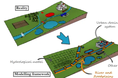
Figure 1 schematizes the developed flexible modelling framework to parsimoniously model the water system at the catchment scale. The modelling framework includes tailored approaches to model the hydrological and hydraulic (both the river and floodplains, and the sewer system) components of the water system. The following paragraphs elaborate on the developed hydrological and hydraulic modelling approaches.
2.1 Hydrological modelling approach
For catchment rainfall-runoff modelling, numerous differ-ent hydrological model conceptualizations and parameteri-zations exist. In order to allow flexibility in the spatial reso-lution, while maintaining consistency in results when spa-tial resolution is changed, and to allow flexible changes in process equations, we developed a flexible hydrologi-cal modelling approach (Tran Quoc and Willems, 2016). This methodology reasons from a generalized lumped model structure that can be disaggregated at various scales to add spatial detail. The use of such an approach that requires only a few parameters to be calibrated is frequently suggested in literature to obviate equifinality issues encountered in hydro-logical modelling (e.g. Jakeman et al., 1990; Wheather et al., 1993). Also, their parsimonious configuration not only fa-cilitates and speeds up model calibration, but their perfor-mance is on average higher compared to more complex dis-tributed models (e.g. Ajami et al., 2004; Breuer et al., 2009). The entire modelling framework is implemented in PCRas-ter – Python. Currently, three conceptual rainfall-runoff mod-els (PDM, Moore, 2007; NAM, Nimod-elsen and Hansen, 1973; and VHM, Willems, 2014) are incorporated because of their widespread use in Belgium. The concept of a flexible model structure also allows the use of an ensemble approach in-volving multiple model types to simulate the rainfall-runoff, thereby obviating the election of one model type over others. Our modelling framework allows convenient, semi-automated disaggregation of the lumped model components to higher spatial resolutions. This allows tailoring model de-tail to the characteristics of specific areas or to the needs for intended applications. This also broadens the range of possible applications, including spatial scenario simulations. The disaggregation is achieved by mapping the different model components on a grid with varying cell sizes. To ensure that consistent results are obtained and the parame-ters have smooth transitions with varying spatial scales, the lumped parameters are disaggregated based on spatial catch-ment characteristics, such as the topography, land use and soil parameters. Only few additional calibration parameters are required to scale the relative spatial differences in model parameters. In the opposite direction, aggregation allows to
Figure 1.Schematization of the proposed modelling framework.
spatially lump processes and transfer a highly spatially de-tailed model to a more lumped model. For further details on this approach, the reader is referred to Tran Quoc and Willems (2016).
2.2 Hydraulic modelling approach
Hydrodynamic models, which are based on the de Saint-Venant equations, have become the standard tool for wa-ter practitioners to simulate rivers and sewer systems. Such models are generally very accurate, but the level of model detail cannot be adjusted, leading to overly complex models for many applications and analyses. Their complicatedness leads to prolonged calculation times. In addition, it is very of-ten difficult or even impossible to interface different models. Linking such models would in turn lead to an even increased complicatedness.
Therefore, we developed a new flexible conceptual mod-elling approach for rivers and sewer systems. The modmod-elling approach simplifies the network topology and momentum equations of the detailed hydrodynamic models according to a lower-fidelity approach (Ravazi et al., 2012) to strike the balance between model accuracy, and computational ef-ficiency and model detail. The modelling approach is incor-porated in the CMD software.
most appropriate model structure based on the dynamics of the river or sewer system, the desired accuracy, available data and the intended applications. Due to variety of model struc-tures, more complex dynamics can also be emulated accu-rately on various scales, such as backwater effects, and pres-surized and reverse flows in pipes. Details of this modelling approach and software can be found in Wolfs et al. (2015).
This conceptual modelling approach has been used be-fore for various applications and case studies, including flood probability mapping (Wolfs et al., 2012), real-time control of hydraulic structures to prevent flooding (Vermuyten et al., 2015), an impact analysis of CSOs on river water quality (Ke-upers et al., 2015) and the quantification of source control versus end-of-pipe solutions on flood probabilities in a cou-pled river-sewer system (De Vleeschauwer et al., 2014). In these studies, the conceptual models were calibrated to sim-ulation results of detailed hydrodynamic models.
2.3 Model interfacing
Interfacing between hydrological and hydraulic models may be bidirectional, but unidirectional coupling was considered so far in this study, where results from the hydrological model are transferred to the hydraulic model at its spatial resolution. The hydrological model is coded in PCRaster-Python, while the hydraulic model is implemented in a C++ executable that can run on Windows and Unix systems. The results of the hydrological model are stored in ASCII format, those of the hydraulic model in netCDF. A simple routine handles the requisite data processing steps when transferring data from the hydrological to the hydraulic model. These in-clude the transformation of data formats, and the adjustment of the save interval (spatial and temporal) of all time series, since the hydraulic model itself does not alter the save in-terval of its input time series. This routine also enables the hydrological and hydraulic models to run in different soft-ware environments, thereby obviating model code adapta-tions. The data transferring routine was coded in MATLAB, since this environment can easily and efficiently handle the used data standards of the hydrological and hydraulic mod-els. Interfacing was done manually for this study, but this process is currently being formalized and automated by the authors. A web processing service interfacing is also being set up to enable interfacing with models and databases in a network.
3 Case study
The hydrological and hydraulic modelling approaches were tested on the Grote Nete catchment in Belgium (see Fig. 2). The catchment has a total area of 385 km2. The most dom-inant land use types in the watershed are cropland (33 %), forest (23 %), grassland (19 %) and built-up area (19 %). The region has predominant sandy soil coverage with parabolic land dunes in the upstream parts, while the downstream
Figure 2.The Grote Nete catchment with the internal flow stations at Meerhout, Vorst and Tessenderlo, and the outlet station at Varen-donk.
parts are characterized by wide alluvial planes with shallow groundwater. The catchment contains numerous river tribu-taries, and a dense network of ditches and subsurface drains that feed into the larger Grote Nete, Molse Nete and Grote Laak rivers.
Four flow gauging stations, six rain gauges and 30 obser-vation wells which monitor groundwater heads are present in the catchment (see Fig. 2). In an earlier study (Vansteenkiste et al., 2014), NAM, PDM and VHM lumped conceptual mod-els were calibrated for this region using a step-wise approach based on the rainfall and flow measurements. The reader is referred to that study for details on this calibration proce-dure. In addition, a detailed hydrodynamic MIKE11 model was configured that comprises these rivers and their main tributaries. This MIKE11 model uses the simulation results of the VHM model as rainfall-runoff input.
Figure 3.Simulated versus observed peak flows after Box-Cox transformation (λ=0.25), for the spatial and lumped models at the Grote Nete downstream catchment station, for the full simulation period 13 August 2002–31 December 2008.
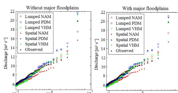
Figure 4.Simulated versus observed peak flow frequency distributions, for the spatial and lumped models at the Grote Nete downstream catchment station, for the full simulation period 13 August 2002–31 December 2008, with and without the effect of the three floodplains with highest capacity.
Thiessen polygon method to the six available rain gauges. The period of 13 May 2002–31 December 2005 was used for calibration, and 1 January 2006–31 December 2008 for validation.
The conceptual hydraulic model was configured for the main rivers in the Grote Nete catchment (see also Fig. 2). Given the availability of an existing and validated detailed hydrodynamic MIKE11 model, and due to the lack of enough measurement data, simulation results of the detailed model were used to calibrate and validate the conceptual model. Calibration was performed on the period 8 March 2001– 11 April 2001, while validation was done for 12 April 2001– 31 December 2008. The investigated river reaches were di-vided in 7 reservoirs. The boundaries of most reservoirs mostly coincide with bridges or culverts. Note that it is easily possible to adjust the number of calculation nodes, and thus
to include additional model detail in specific areas. The main floodplains with a total capacity of 200 000 m3were also in-corporated in the conceptual model. These floodplains are situated just upstream of the outlet station of the catchment. After the model topology was defined, the most appropriate model structures were identified and calibrated. The flow was predominantly modelled using transfer functions, while rat-ing curves were applied to model the water levels. Besides visual comparison of the conceptual and detailed hydrody-namic model results, the NSE values were also calculated using the conceptual and MIKE11 simulation results. The performance of the hydraulic model is exceptionally good, with NSE values for all flows and water level results exceed-ing 0.985 for both the calibration and validation events.
dis-tributed versions) were interfaced with the conceptual river model. In this way, six different integrated models were ob-tained.
4 Results
The results of the interfaced hydrological – hydraulic con-ceptual models were evaluated based on the flow observed at the catchment downstream gauging station. This is done us-ing four methods: (i) visual comparison of the observed and simulated river flows at the gauging stations, (ii) evaluation of a set of five statistical measures, (iii) control of the water balance and (iv) analysis of evaluation plots focusing on ex-tremes and cumulative values as proposed in Willems (2009). For the peak flow extremes (Figs. 3, 4), the spatial and lumped models show similar performance and frequency dis-tributions: whereas the peak flow error (PFE) after Box-Cox (BC) transformation (Box and Box-Cox, 1964) ranges be-tween−0.10 and 0.15 BC(m3s−1) (BC parameterλ=0.25) for the lumped models, its value range between 0.11 and 0.18 BC(m3s−1) for the spatial models. For PDM, the spa-tial models are slightly more accurate or of equal accuracy for the peak flows as the lumped models, whereas for other models (NAM, VHM) the opposite is observed. The differ-ences are, however, for all models minor.
Figure 4 shows the empirical peak flow frequency distri-bution for all configured models at the most downstream sta-tion. In order to investigate the influence of the river flood-ing on the river peak flow dynamics and statistics, the hy-draulic model simulations were conducted with and without the floodplains with the highest capacity. It is seen in Fig. 4 that the floodplains only affect the highest flows. Closer in-spection of the simulation results revealed that only two of the three floodplains were filled during the entire simulation period of more than six years, explaining the minor influence on the peak flows for the lower return periods. Note that all models overestimate the flow for empirical return periods be-tween one and three years. Including also the numerous much smaller floodplains along the more upstream tributaries in the catchment will likely reduce the simulated flows in that range of return periods.
A similar conclusion holds for the low flow extremes. The low flow accuracy is fair for both the lumped and spatial models: LFE between 0.02 and 0.18 BC(m3s−1) (λ=0.25). One again does not see strong differences in the low flow performance between the lumped models (LFE between 0.04 and 0.18 BC(m3s−1)) and the spatial models (LFE between
0.02 and 0.18 BC(m3s−1)). The cumulative runoff volumes are for many models slightly underestimated but limited to 10.63 %, which is fair. Most models show lower differences: WBE between −10.63 and +4.11 % for the spatial models and between−10.11 and−0.80 % for the lumped models.
Given this good accuracy, the models hence can be consid-ered useful for impact studies on peak flow extremes (flood
studies), low flow extremes (water availability studies) and cumulative runoff volumes (water balance studies). The spa-tial models are applicable for scenario studies that do in-volve spatial land use changes, whereas the lumped models are useful for other types of scenarios studies and to reduce the computational times. For the lumped models, the calcu-lation times were 103to 106shorter when compared to the detailed models. The lumped and spatial models moreover produce consistent results, as is shown by Tran Quoc and Willems (2016) for impact analysis of climate change sce-narios.
5 Discussion and conclusions
The proposed approach successfully derived for the study catchment an accurate and fast combined conceptual rainfall-runoff and river hydraulic model. It was based on a modelling framework developed to incorporate several approaches to parsimoniously model the catchment hydrology and the hy-draulics of rivers, floodplains and sewer systems. Albeit not shown in this paper, this flexible modelling framework can deliver hydrological and hydraulic models that can be config-ured with varying resolutions and provide consistent results. Further extensions are possible to the sewer systems in the catchment. The level of model detail can be tailored to the investigated scale, dynamics of the system and the intended application. Overly complicated models are both data- and time-demanding to set up. In addition, such complicatedness can lead to equifinality issues, prolonged calculation times, increased model uncertainties and even inaccurate simula-tions due to the accumulation of model uncertainties and dis-crepancies.
Acknowledgements. The authors would like to thank DHI for the MIKE11 license. The Province of Antwerp and the Flemish En-vironment Agency (VMM) are also gratefully acknowledged for providing measurement data of the cross-sections of the rivers in the Grote Nete catchment such that the hydrodynamic river model could be set up.
References
Ajami, N. K., Gupta, H., Wagener, T., and Sorooshian, S.: Calibra-tion of a semi-distributed hydrologic model for streamflow esti-mation along a river system, J. Hydrol., 298, 112–135, 2004. Box, G. E. P. and Cox, D. R.: An analysis of transformations, J.
Roy. Stat. Soc., 26, 211–243, 1964.
Breuer, L., Huisman, J. A., Willems, P., Bormann, H., Bronstert, A., Croke, B. F. W., Frede, H.-G., Gräff, T., Hubrechts, L., Jakeman, A. J., Kite, G., Lanini, J., Leavesley, G., Lettenmaier, D. P., Lind-ström, G., Seibert, J., Sivapalan, M., and Viney, N. R.: Assessing the impact of land use change on hydrology by ensemble model-ing (LUCHEM) I: Model intercomparison with current land use, Adv. Water Resour., 32, 129–146, 2009.
De Vleeschauwer, K., Weustenraad, J., Nolf, C., Wolfs, V., De Meulder, B., Shannon, K., and Willems, P.: Green-blue water in the city: quantification of impact of source control versus end-of-pipe solutions on sewer and river floods, Water Sci. Technol., 70, 1825–1837, 2014.
Jakeman, A. J., Littlewood, I. G., and Whitehead, P. G.: Computa-tion of the instantaneous unit hydrograph and identifiable com-ponent flows with application to two small upland catchments, J. Hydrol., 117, 275–300, 1990.
Keupers, I., Wolfs, V., Kroll, S., and Willems, P.: Impact analysis of sewer overflows on the receiving river water quality using an integrated conceptual model, Proceedings of the 10th confer-ence on Urban Drainage Modelling (10UDM), 20–23 September 2015, Québec, Canada, 2015.
Moore, R. J.: The PDM rainfall-runoff model, Hydrol. Earth Syst. Sci., 11, 483–499, doi:10.5194/hess-11-483-2007, 2007.
Nielsen, S.-A. and Hansen, E.: Numerical simulation of the rainfall-runoff process on a daily basis, Nord. Hydrol., 4, 171–190, 1973. Ravazi, S., Tolson, B. A., and Burn, D. H.: Review of surrogate modeling in water resources, Water Resour. Res., 48, W07401, doi:10.1029/2011WR011527, 2012.
Tran Quoc, Q. and Willems, P.: Flexible conceptual hydrological modelling – Disaggregation from lumped catchment scale to higher spatial resolutions, submitted, 2016.
Vansteenkiste, T., Tavakoli, M., Ntegeka, V., De Smedt, F., Bate-laan, O., Pereira, F., and Willems, P.: Intercomparison of hydro-logical model structures and calibration approaches in climate scenario impact projections, J. Hydrol., 519, 743–755, 2014. Vermuyten, E., Meert, P., Wolfs, V., and Willems, P.: Using a
fast conceptual river model for floodplain inundation forecast-ing and real-time flood control – a case study in Flanders, Bel-gium. 21st International Congress on Modelling and Simulation (MODSIM2015), 29 November–4 December 2015, Broadbeach, Queensland, Australia, 2015.
Wheather, H. S., Jakeman, A. J., and Beven, K. J.: Progress and directions in rainfall-runoff modeling, in: Modelling change in environmental systems, edited by: Jakeman, A. J., Beck, M. B., and McAleer, M. J., John Wiley & Sons, 102–132, 1993. Willems, P.: A time series tool to support the multi-criteria
per-formance evaluation of rainfall-runoff models, Environ. Model. Softw., 24, 311–321, 2009.
Willems, P.: Parsimonious rainfall-runoff model construction sup-ported by time series processing and validation of hydrological extremes – Part 1: Step-wise model-structure identification and calibration approach, J. Hydrol., 510, 578–590, 2014.
Wolfs, V., Van Steenbergen, N., and Willems, P.: Flood probabil-ity mapping by means of conceptual modelling, in: River Flow 2012: Vol. 2. International Conference on Fluvial Hydraulics, edited by: Muñoz, R., Costa Rica, 5–7 September 2012, 1081– 1085, London: CRC Press, Taylor & Francis Group, 2012. Wolfs, V., Meert, P., and Willems, P.: Modular conceptual modelling