c
Episodic Uplift along a Quaternary Fault, A Signature of Active Deformation in Frontal Part
of Karachi Arc, Southern Pakistan
Ahmad Nabi
1, 2*, Xiaodong Liu
1, Zhijun Gong
1Khalid Pervaiz
2, Abbas Ali
1&2Shahbaz Ashraf
21
East China University of Technology Guanglan Road No. 418, Nanchang, Jiangxi 330013, China
2
Atomic Energy Minerals Centre, Lahore-54600, Pakistan
*
Email:ahmadnabi74@yahoo.com
Received: 15May, 2018 Accepted: 8 August, 2018 Abstract: The southern part of Kirthar Fold Belt represents a divergent wrench regime marked by open arcuate structures, collectively called as Karachi Arc. The frontal part of Karachi Arc is being actively deformed. The active deformation is manifested by the neotectonic features recorded in the recent sediments. Frontal part of northern Karachi Arc has been investigated to locate Earthquake Environmental Effects (EEE) in Bizan Dhoro area northwest of Hyderabad. A linear structure in Bizan Dhoro area at frontal part of northern Karachi Arc has been investigated. The structure was interpreted in front of Laki Range with the help of LANDSAT ETM and SPOT Images. The lineament on ground is represented by a NNW oriented linear topographic step in the peneplain alluvial fans. The frontal peneplain of Laki Range is constituted by the alluvial fans composed of clast supported gravel ranging from pebble-to-boulder in size laid down by Bizan Dhoro and its tributaries. Four new generations of alluvial fans have been recognized across the lineament which suggests that the area has experienced at least three episodes of uplift along the topographic step named as Bizan Dhoro Fault. Electric resistivity tomography across Bizan Dhoro fault and evidences of tectonic geomorphology revealed that it is a capable reverse fault dipping at an angle of 60° towards west which has experienced at least three events after deposition of Quaternary alluvial fans. No brittle deformation however could be recorded in the gravels. Bizan Dhoro fault is an embryonic structure that depicts active deformation of foreland parallel to the fold and thrust belt.
Keywords: Neotectonic, earthquake environmental effects, Karachi Arc, Kirthar fold belt.
Introduction
Neotectonics is the study of geological and geomorphological deformation process in recent or current geological time. Neotectonic studies are the only reliable tool that provides adequate information about moderate to great these events. The intensity of these events is determined by the degree of deformation experienced by recent sediments.
The instrumental record since 1904 and historical record of earthquakes spanning over a few centuries is insufficient to discriminate the seismogenic faults and to assess their seismic potential. The repeat time of seismic events associated with a seismogenic structure may surpass the time span of human history. The repeat time of seismic events associated with seismogenic faults sometimes may exceed thousands of years. The deformation caused by the earthquake is recorded by the younger sediments which are otherwise undeformed. In such conditions only neotectonic investigations provide significant samples for seismic analysis and modeling.
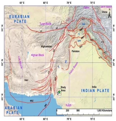
The neotectonic studies have been conducted in frontal part of northern Karachi Arc, Kirthar fold belt, lower Indus basin around Bizan Dhoro stream which is located in district Jamshoro, about 23 km south of Sehwan and 170 km northeast of Karachi city. The
Figure 1 indicates the location of study area in tectonic map of Pakistan. The Bizan Dhoro stream is dissecting the Piedmont forelands of Laki Range. Relative chronology and position of the facets along Bizan Dhoro stream have been used to discriminate recent deformation. The area is comprised of alluvial fans composed of clast supported gravel ranging from pebble-to-boulder in size deposited by Bizan Dhoro stream and its tributaries. At the topographic step new generation of alluvial fans has been developed that indicates a movement along the linear structure which resulted into development of new alluvial fans. Electric resistivity tomography across the lineament was conducted to know its subsurface behavior. The basic aim of the study is seismic hazard assessment and to study the earthquake environmental effects by comparing them with the ESI scale 2007.
Regional Geology and Tectonics
Pakistan is gifted with two main sedimentary basins, known as Baluchistan and Indus, which are separated by Bela-Ornach-Chaman transform fault system in the onshore and Murray ridge in the offshore. (Nazeer et al., 2012-2013). These basins are incised with mountain ranges, fold and thrust belts, fore-deeps, oceanic trench and platforms (Fig. 1). The Indo-Pakistan plate rotated anticlockwise due to its oblique collision with Eurasian plate, which formed into the
development of large scale basement faults namely Kirthar, Sulaiman and Jhelum Basement faults. These faults segmented Indo-Pakistan plate into numerous basement blocks. Different tectonic patterns on the individual block were formed by the movement of these blocks during ongoing tectonic collision. (Bannert and Raza, 1992; Nazeer, 2012-2013). Sulaiman and Kirthar fold belts are parts of western fold belts of Pakistan. Thus, wide range of sediments from Infra-Cambrian to Recent, from carbonate to clastics were deposited in present Indus basin and interpreted by different authors (Khan et al., 1986; Malik et al., 1988; Raza et al., 1989; Shah, 2009 and Nazeer et al., 2012-2013).
Fig. 1 Regional tectonic framework of the northwestern Indian plate margin and Eurasia with location of study area. (Modified after Taylor and Yin, 2009; Mohadjer et al., 2010; Ul-Hadi et al., 2013) (MKT: Main Karakorum Thrust, MMT: Main Mantle Thrust, SRT, Salt Range Thrust, STD, South Tibetan Detachment, MCT: Main Central Thrust, MFT: Main Frontal Thrust, PB: Peshawar Basin, KPP Kohat Potwar Plateau, HF: Herat Fault, CF: Chaman Fault, NF: Nal Fault, SR: Surghar Range, ST: Sibi Trough, MSZ: Makran Subduction Zone, KR: Kirthar Range, KA: Karachi Arc).
Kirthar Fold belt (Fig. 2) extends from western limit of Indus basin along Ornach-Chaman fault systems which merges into Kirthar Foredeep in the east; in north it extends up to Sibi-Quetta-Syntaxes. The Kirthar Fold belt is north–south trending in north, where straight upright anticlines are the product of distributive sinistral Cenozoic transpressive wrench faults (Ahmed and Ali, 1991). The southern parts of Kirthar fold belt represent a divergent wrench regime. It is marked by open arcuate structures (Fig. 2) collectively called as Karachi arc (Hunting Survey Corporation, 1961; Kazmi et al., 1982). Sediments from Mesozoic to Recent are exposed in the surroundings of Bizan Dhoro area and involved in deformation. The Bizan
Dhoro area lies in the southern part of Kirthar fold belt of Pakistan (Fig. 3).
Fig. 2 Satellite image of central and southern Kirthar fold belt showing seismogenic and other faults.
Fig. 3 Satellite image of Bizan Dhoro area (AA line is Bizan Dhoro lineament and CD line is showing the electrical resistivity survey line).
indicated by east verging structures that result due to India-Arabia convergence (Sarwar, 1992; Niamatullah, 1997). The Karachi Arc is comprised of a series of parallel to sub-parallel, short, narrow, serrate, arcuate (convex to east), en-echelon ridges and wide, dome shaped anticlinal hills. Schelling (1999) described that in the north-eastern Karachi Arc, major anticlines are generally located at the hinging walls of thrust faults which offsets anticlinal forelimbs and/or adjacent, overturned synclinal hinges and which record total displacement to 1,000 meters. The Karachi Arc has been reported as tectonically active that shows Neogene thin- skinned eastward movement. The frontal part of Karachi Arc is active as manifested by the presence of neotectonic features along high-angle reverse faults (Sarwar and DeJong, 1979; Schelling, 1999). Historical and instrumental seismic events in the Karachi Arc depicts that the arc is tectonically active (Quittmeyer et al., 1979; Bilham et al., 2007; Sarwar and Alizai, 2103).
The Paleozoic rocks are not exposed in the study area; however, these rocks have been confirmed by drilling (Raza et al, 1989). The northern Karachi Arc and surrounding area is comprised of a variety of rocks ranging in age from Mesozoic-to-Quaternary (Malkani and Zafar, 2016). These rock units are variegated in lithology and age. The early Jurassic-to-middle Cretaceous rocks are mainly limestone with subordinate calcareous shale. The late Cretaceous-to-middle Paleocene-to-Eocene rocks are also dominantly limestone with minor calcareous shale. Middle-Miocene-to-Quaternary rocks are composed of sandstone, shale, conglomerate, alluvial sand, silt and clay (Fig 8). Generalized stratigraphy of study area is given in Table 1.
Materials and Methods
A detailed study of Recent and Sub-recent strata was carried out in terms of their deformation to know the intensity of seismic activity in the area during recent times i.e. <0.1million years.
Satellite data more interpreted and Bizan Dhoro with surrounding areas was earmarked to display the propagation of faults from rock outcrops to recent deposits indicating their activity in the recent times. Recent sediments are mainly found along stream beds as terraces, on the top of uplifted older rocks and in intermountain basins.
Possible fault plane exposures in the Bizan Dhoro area were examined and measured laterally and vertically, the offset features were studied such as stream banks, ridges, terrace surfaces and hill slopes along the length of lineament to determine seismic events and cumulative displacements.
Electrical resistivity high density tomography across the lineament that is concealed under younger terraces was carried out to know the subsurface behavior.
Electrical Resistivity Tomography (ERT) is an advanced geophysical method, by which is measured the subsurface resistivity distribution by taking measurements on ground surface. ERT is the inverse of conductivity, which means subsurface lithology with high conductivity will give low resistivity value. ERT data more collected with multi-electrode resistivity meter. ERT profile consists of electrical resistivity measured in Ω·m versus depth.
Results and Discussion
A NNW trending lineament was interpreted on ETM (Enhanced Thematic Mapper) satellite image of Sehwan and adjoining areas. Further detailed interpretations of satellite image (Fig. 3) revealed that the lineament cut across the piedmont of Laki Range was about 23km south of Sehwan. The lineament is the
expression of linear topographic step in proximal part of the fan (Fig. 4).
Fig. 4 Panoramic view of Bizan Dhoro fault (red line) clearly indicated between reliefs of topographic features (HW: Hanging Wall, FW: Foot wall).
The junction of piedmont and Laki Range is linear however there is no range bounding fault in north of Bizan Dhoro. The linear junction is due to asymmetric anticlinal fold with steeper piedmont facing eastern limb. The anticline however, is marked by internal reverse and oblique slip faults. In the south of Bizan Dhoro, the piedmont–range junction shifts towards east along faulted plunge of frontal anticline. The fault through the plunge has tilted Pleistocene and Sub recent fanglomerates while upper un-deformed Quaternary gravel lies unconformably over tilted fanglomerate (Fig. 5).
ERA
EPOCH
PERIOD
FORMATION
LITHOLOGY
C E
N O
Z
O
I
C
Sub-Recent and
Recent
Boulder beds and sand terraces,
clayey soil developed along
present day streams.
PLEISTOCENE
Dada Conglomerate
Coarse boulder & pebble
conglomerate with subordinate
coarse, cross bedded sandstone
PLIOCENE
LATE
Manchar Formation
Sandstone & shale with
subordinate conglomerate
MIOCENE
MIDDLE
Gaj Formation
Calcareous, ferruginous & cross
bedded sandstone & variegated
shale
OLIGOCENE
EARLY
Nari Formation
Shale, sandstone and siltstone
EOCENE
MIDDLE
Brahui
limestone(Khude
Limestone/ Jakker
Group
Inter-bedded limestone and shale
with minor marl
Laki Formation
Limestone, marl, shale with
subordinate sandstone and
conglomerate
EARLY
Tiyon Formation
Inter-bedded limestone and shale
with minor marl
PALEOCENE
LATE
Rani
Kot
Group
(Karkh
Group)
Lakhra
Formation
Dominant limestone
MIDDLE
Bara
Formation
Sandstone with lesser shale and
minor volcanic debris
EARLY
Khadro
Formation
Sandstone and shale with
limestone
M
E S
O
Z O
I
C
CRETACEOUS
LATE
Pab Sandstone
White creamy or brown thick
bedded massive quartzose
sandstone with subordinate
calcareous shale
MIDDLE
Parh Limestone/
Parh Group
Limestone with subordinate shale
Bela Volcanic
Group
Volcanic shows extreme variation
JURASSIC
EARLY
Shirinab
Formation/
Winder Group
Four generations of alluvial fans (Fig. 6) have been recognized along Bizan Dhoro lineament. The older alluvial fan (area marked as 1 in Fig 6b) in front of Laki Range has been up thrown along the 5-7-meter-high linear topographic step (Fig 4). The topographic step gradually loses its height towards north and southwards as it is terminated against plunge of frontal anticlinal fold. The trunk stream of the area is Bizan Dhoro. It is entrenched up to the bedrock through its older alluvial fan forming paired terraces at both banks. The course of Bizan Dhoro is directed to the east in this entrenched part and abruptly it is deflected at right angle towards north along the topographic step and then stream course again leaves the linear feature to follow the regional gradient to the east. Three generations of young alluvial fans have been developed here by the Bizan Dhoro.
Fig. 6 (a) Satellite image showing alluvial fans along Bizan Dhoro fault. (b) Four generations of alluvial fans along the fault have been recognized, area marked as “1” are the oldest alluvial fans while no “4” are the youngest alluvial fans.
The trunk stream i.e. Bizan Dhoro becomes a shallow and multi-channel stream along the linear topographic step and when it leaves the lineament to drain eastwards to Indus river it sheds its load in the form of younger alluvial fans at footwall. The tributaries of trunk stream are also entrenched into the older up-thrown alluvial fan in west of topographic feature and show some degree of deflection while crossing through the lineament. Deflection and offset in courses of small streams in proximal part of alluvial fan have also been observed just in south of Bizan Dhoro area along a north-south oriented lineament which is in the directionof Bizan Dhoro lineament. It may be regarded as southern extension of Bizan Dhoro lineament.
Electrical resistivity tomography across the linear
feature reveals that it is a reverse fault dipping at an angle of 60° to the west (Fig 7). The data reveals about 6 meters of vertical component of the offset. The sand-shale sequence of Manchar Formation of Pliocene age under the piedmont alluvial fans provides good signature of the fault named as Bizan Dhoro fault.
Fig. 7 Electrical resistivity tomography profile across Bizan Dhoro fault.
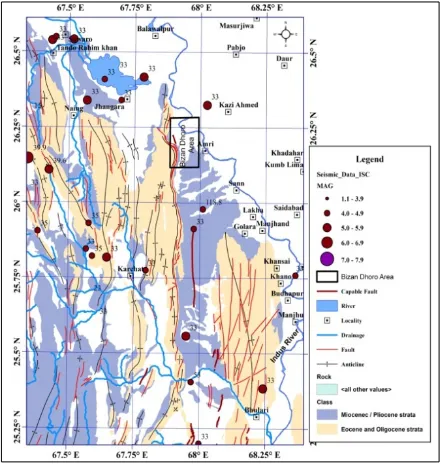
The instrumental seismicity of International Seismic Centre (ISC) was plotted on the structural map of northern Karachi Arc using Arc GIS (Fig 8). Twenty-three (23) earthquake epicentres of magnitude ranging from 3 to 6 are located within the area covered by Figure 8 and the epicentres are sparsely distributed. The lower frequency of seismic events reveals that the Bizan Dhoro area is characterized by minor seismic events.
Fig. 8 Litho-structural Map of northeastern Karachi arc, southern Pakistan showing epicenters locations (Seismic data source: International seismological Centre, UK)
long axis of clasts has been rotated to vertical, however breaking of pebbles could not be observed.
The Bizan Dhoro fault has limited surface expression of few km strike lengths. However, evidences of tectonic geomorphology and geophysical surveys suggest that Bizan Dhoro fault is capable and has experienced at least three events after the deposition of older alluvial fan in Subrecent. The Hunting Survey (1961) has assigned Subrecent age to the older alluvial fans.
Comparing the rupture length, offset and geomorphological evidences with Environmental Seismic Intensity Scale 2007 (Michetti et al., 2007; Serva et al., 2016), intensity VII-IX can be assigned to the Bizan Dhoro fault. No modern seismic event has been recorded along the fault and Environmental Seismic Intensity (ESI) VII to IX might be assigned on the basis of analysis of degraded fault scarp and earthquake environmental effects (EEE).
Earthquake environmental effects (EEE) are all the effects that a seismic event can induce on the natural environment such as geological, hydrological, physical and metrological effects (Michetti et al. 2007). Moderate to large crustal earthquakes produce common features (EEE) both in the fields near them and far away. Always noted and surveyed in recent events, very often they are remembered in historical accounts and conserved in the stratigraphic record as paleo-earthquake markers, the latter being the basis of paleoseismology (Mccalpin, 2009).
Incipient structures depicted in the form of lineaments in the northern foreland (Bizan Dhoro fault) are indicators of active deformation of northern Karachi Arc in its frontal parts. The inference is further supported by the seismic behavior of the internal parts of the arc. Some micro to small seismic events are located in this area, however the focal depths of the events are more than 30 km (Fig. 8). It suggests that the events originated from the base of the crust while the sedimentary cover is inactive. Shallow earthquake events with less than 10 km depth and crustal events of more than 30 km depth co-exist in Jhimpir area which indicates that the active shield structures are controlling the deformation in the sedimentary cover.
Conclusion
• Evidences of tectonic geomorphology and electrical resistivity tomography (ERT) have proved the Bizan Dhoro lineament as reverse fault dipping at an angle of 60° to the west.
• The fault has experienced at least three seismic events after the deposition of older alluvial fan in subrecent and Intensity of VII-IX of ESI-2007 can be assigned to the fault on the basis of EEE and fault scarp.
• Incipient structures depicted in the form of lineaments in the northern foreland (Bizan Dhoro fault) are indicators of active deformation of northern Karachi Arc in its frontal parts.
Acknowledgements
We acknowledge Pakistan Atomic Energy Commission (PAEC), China National Nuclear Corporation (CNNC), and East China University of Technology (ECUT), China for providing facilities to carry out this intensive research work. We are grateful to Mr. Haseeb Ur Rehman Hashmi and Mr. Imran Mahmood of Atomic Minerals Centre “AEMC”, Lahore, Pakistan, for providing their valuable guidance in geophysical investigation. We are also very grateful to the reviewers for constructive suggestions to improve the article.
References
Ahmed, R., and Ali, S. M. (1991). Tectonic and structural development of the eastern part of Kirthar fold belt and its hydrocarbon prospects. Pakistan Journal of Hydrocarbon Research, 3 (2), 19-31.
Bannert, D., Raza, H. A. (1992). The segmentation of the Indo-Pakistan Plate. Pakistan Journal of Hydrocarbon Research, 4 (2), 5-18.
Bilham, R., Lodi, S., Hough, S., Bukhary, S., Khan, A. M., Rafeeqi, S. F. A. (2007). Seismic hazard in Karachi, Pakistan: Uncertain past, uncertain future. Seismological Research Letters, 6, 601-613.
Hunting Survey Corporation, Ltd. (1961). Reconnaissance geology of part of West Pakistan. Colombo Plan Cooperative Project, Toronto, Ontario, Canada, 550 pages.
International Seismological Centre (ISC), UK. Event catalogue, http://isc.ac.uk.
Kazmi, A. H., Rana R. A. (1982). Tectonic map of Pakistan. Geological Survey of Pakistan Special Publication.
Khan, M. A., Ahmad, R., Raza, H. A., Kemal, A. (1986). Geology of petroleum in Kohat-Potwar depression, Pakistan. American Association of Petroleum Geologists Bulletin, 70 (4), 396-414.
Malik, Z., Kemal, A., Malik, M. A., Bodenhausen, J. W. A. (1988). Petroleum potential and prospects in Pakistan. In Petroleum for the future. H. A. Raza and A. M. Sheikh (eds.), HDIP., Islamabad, 71-99.
Mccalpin, J. P. (2009). Paleoseismology. 2nd Edition, International Geophysics Series, 95, Elsevier Publishing, 647 pages.
Michetti, A. M., Esposito, E., Guerrieri, L., Porfido, S., Serva, L., Tatevossian, R.,Vittori, E., Audemard, F., Azuma, T., Clague, J., Comerci, V., Gurpinar, A., McCalpin, J., Mohammadioun, B., Morner, N. A., Ota, Y., Rogozhin, E. (2007). Intensity scale ESI-2007. In Memorie Descrittive della Carta Geologica d’Italia. L. Guerrieri and E. Vittori (eds.), APAT., Rome, 74, 7-54.
Mohadjer, S., Bendick, R., Ischuk, A., Kuzikov, S., Kostuk, A., Saydullaev, U., Lodi, S., Kakar, D. M., Wasy, A., Khan, M. A., Molnar, P., Bilham, R., Zubovich, A. V. (2010). Partitioning of India– Eurasia convergence in the Pamir-Hindukush from GPS measurements. Geophysics. Res. Lett., 37, 1-6.
Nazeer, A., Solangi, S. H., Brohi, I. A., Usmani, P., Napar, L. D., Jahangir, M., Hameed, S., Ali, S. M. (2012-2013). Hydrocarbon Potential of Zinda Pir Anticline, Eastern Sulaiman fold belt, Middle Indus Basin, Pakistan. Pakistan Journal of Hydrocarbon Research, 22 - 23, 73-84.
Niamatullah, M. (1997). Geometry and tectonic of the Ornach – Nal Fault, A southern extension of the Chaman Transform zone, Pakistan. ACTA Mineralogica Pakistanica., 8, 1-8.
Quittmeyer, R. C., Farah, A., Jacob, K. H. (1979). The seismicity of Pakistan and its relation to surface faults. In Geodynamics of Pakistan. Farah, A. and DeJong, K. A. (eds.), Geological Survey of Pakistan., Quetta, 271-284.
Raza, H. A., Ahmed, R., Ali S. M., and Ahmad J. (1989). Petroleum prospects: Sulaiman sub-basin, Pakistan. Pakistan Journal of Hydrocarbon Research., 1 (2), 21-56.
Sarwar, G., Alizai A. (2013). Riding the mobile Karachi Arc, Pakistan: Understanding tectonic threats. Journal of Himalayan Earth Sciences., 46 (2), 9-24.
Sarwar, G. (1992). Tectonic setting of the Bela Ophiolites, southern Pakistan. Tectonophysics., 207, 39-381.
Sarwar, G., Dejong K. A. (1979). Arc oroclines, syntaxes: the curvatures of mountain belt in Pakistan. In Geodynamics of Pakistan. Farah, A. and DeJong, K. A. (eds.), Geological Survey of Pakistan., Quetta, 341-349.
Schelling, D. D. (1999). Frontal structural geometries and detachment tectonics of the northeastern Karachi arc, southern Kirthar Range, Pakistan. In Himalaya and Tibet: Mountain Roots to Mountain
Tops. Macfarlane, A., Sorkhabi, R. B., Quade, J., (eds.), Geological Society of America Special Paper., Colorado, 328, 287-300.
Serva, L., Vittori, E., Comerci, V., Esposito, E., Guerrieri, L., Michetti, A. M., Mohammadioun, B., Mohammadioun, G. C., Porfido, S., Tatevossian, R. E. (2016). Earthquake hazard and the environmental seismic intensity (ESI) Scale. Pure Applied Geophysics, 173 (5), 1479-1515.
Shah, S. M. I. (2009). Stratigraphy of Pakistan. Memoirs, 22, Geological Survey of Pakistan, Pakistan, 381pages.
Taylor, M., Yin, A. (2009). Active structures of the Himalayan–Tibetan orogen and their relationships to earthquake distribution, contemporary strain field, and Cenozoic volcanism. Geosphere, 5, 199–214.
Ul-Hadi, S., Khan, S. D., Owen, L. A., Khan, A. S., Hedrick, K. A., Caffee, M. W. (2013). Slip-rates along the Chaman fault: Implication for transient strain accumulation and strain partitioning along the western Indian plate margin. Tectonophysics, 608, 389–400.