* To whom all correspondence should be addressed.
The Way of Structural Interpretation of Potential Fields Under
Condition of a Priori Geological Information Minimum
Igor B. Movchan and Alexandra A. Yakovleva
National Mineral Resource University (University of Mines) Russia, 199106, St.-Petersburg, Vasil’evsky island, 21st line, 2, Russia
doi: http://dx.doi.org/10.13005/bbra/1455
(Received: 27 September 2014; accepted: 10 October 2014)
The aim of paper is in development of interpretation of potential and quasipotential fields which in geophysics traditionally includes the qualitative and quantitative approaches. To the first interpretation they relate the transformations of structure of measured signal: filtration and zoning. At the stage of qualitative interpretation the processed field is considered in the area of absence of sources of its anomalies and these fields keep the analyticity. The quantitative interpretation is in various recalculations of field in the depth, i.e. in the area of existence of anomalous geological sources in the small vicinity of which the gravitational, magnetic and electric potentials approach infinity. Under such transformations the geometrical and physical parameters of heterogeneities of geological half-space are reconstructed by the methods of solution of ill-posed problems. The last ones has some peculiarities: on one hand, it takes time with regard to the qualitative interpretation and, on the other hand, it rouses censure within geologists because of the necessity of simplification of reconstructed heterogeneities in geological media. The solution of ill-posed problem always has multivalued character: one anomaly corresponds to a wide class of models of geological heterogeneities with significant difference in geometry, elements of bedding, average physical properties. This difficulty is overcame by the set of independent methods of analytical continuation, one of which gives the structural image of geological cross section which is comparable to the seismic cross section.
Key words: Inverse problem, models, interactive fit, structural image, potential signal.
Today the theory of methods of solution of incorrect problems is considered in details since the end of seventieth years (Tikhonov and Arsenin, 1979), up to the set of fundamental publications (Serkerov, 2007; Strahov, 2002; Cirulskyj, 2005). In the problem of reconstruction of parameters of the source inaccessible for direct supervision we have the next determinate approaches (Movchan and Yakovleva, 2005):
* the analytical recalculation of values of measured potential signal in the area of existence of its source (Kellog, 1953) with plotting the structural image of given signal in this area;
* Application of approximated methods and the theory of singular integrals (Lynn and Timlake, 1968) for computing family of singular points in the area of existence of anomalous sources;
consecutive changing the geometry of these bodies and their effective physical parameters (effective density, effective magnetic susceptibility).
Considered in general operator form the theory of these methods was developed by the set of applied algorithms from empirical quantitative estimations of anomalies (its amplitude and a mutual position of points of extremum and inflexion (Wolters et al., 2007)) to 3D-fitting the structure of geological half-space. In our case the choice of algorithm is caused by minimum of a priori information when we have just potential fields measured along the surface and the general geological information about structural-tectonic position of polygon. Besides there are two additional restrictions:
* The results of quantitative interpretation should be derived by mathematically independent ways, but these results must provide the significant mutual correlation that reduces the number of equivalent solutions;
* Mentioned results should give the images of structural and ore geological objects obvious both for geophysics, and for the traditional geologist.
MATERIALS AND METHODS
The analytical continuation, as basis of structural-geological reconstructions, is in the recalculation of potential signal F(x) in spectrum plane S() ( [omega]- spatial frequency) with the subsequent application of transfer functions to the real and imaginary parts of Fourier spectrum and final transformation of filtered spectrum to object plane with plotting structural image of signal on required depth zH (Roy, 2008). The transfer function
P() = exp (H.||),
used for recalculation from conditionally zero depth
z
on arbitrary depth
H
S(,H) = S (,0) . P (),
is focused on the selection of high-frequency spectrum harmonics, that for rather small depths generates the high-amplitude oscillations in the structure of potential field. Here the simplest way of regularization is smoothing potential field which is carried out in spectrum plane by transfer
function, selecting the low frequencies by, for example, Hemming function
P' () = 1+cos (x/N)
where N - number of pickets along the profile with defined values of potential field. After such smoothing the short-wave component of the signal, including the responses from subsurface singularities, is suppressed (Zhdanov et al., 2010). For simplification of procedure we assume: - The wave-length of component of
continued signal is proportional to the depth of particular singular points; - Low-frequency component of signal isn’t
taken into account for computing subsurface singularities;
- While increasing the depth of analytical continuation the high-frequency range is eliminated and the amplitude of low-frequency harmonics of signal grows proportionally to this depth.
Finally the problem is reduced to analytical expression of family of narrow-band filters like P().P'(), forming within pass band the dome-shaped transfer function, excluding [delta]-like zeroing of Fourier spectrum of potential field on the edges of pass-band. On small depths the extremum of transfer function belongs to the high frequencies (w<2/ x, x, - the step of discretization of transformed field) and low frequencies with average frequencies are suppressed. While increasing the depth of analytical continuation the extremum of transfer function is consecutively displaced in the area of average frequencies with increasing suppression of high-frequency harmonics and relative increase in amplitude of low-frequency harmonics.
In conditions of bounded sample the spectrum transformations give the significant distortions in the structure of final signal, i.e. analytical continuation must be considered in the object plane. Here there is the effective calculation of normalized gradient, analytically continued in geological half-space (Karsli and Bayrak, 2010):
.
last one is expanded in Fourier series which are bounded by odd functions because of faster convergence. Restriction of members number of these series defines the application of weight function Pn,m,, that for any depth z of analytical continuation gives for function U(x,z) the next expression
,
where
-expansion coefficients,
-weight function of the pass-band filter, in which 2
m . Then
.
According to experience the limiting depth of analytical continuation z=H, at which there is no influence of bounding sample and finite members number in odd part of Fourier series, should be no more than 1/5 from length of observation profile L. Considered way of analytical continuation is applied directly to gravity field, but in the case of magnetic field Ta one has to do the reduction to the pole (Ansari and Alambar, 2009).
The continuous structure of potential field in geological half-space is correct in the case of reflection of density heterogeneous distribution. The magnetized heterogeneities, which cause the complicated structure of Ta, are distributed discretely in this half-space, i.e. we need to add the calculation of singularities position and their classification to the structural image of analytically continued magnetic field. In this problem we use Cauchy integral (Cakoni and Kress, 2007)
,
(*) where U() - result of analytical
continuation in the area [capital lambda], which represents crossing geological half-space and circular template. The last one has radius R=|-0| and the geometrical center in point 0=x0-(x0 is the projection of template geometrical center on profile line, h is the height of this center with regard to the surface). Besides t=x+iz is the current coordinate along the profile, z - absolute heights; k [tau sub k] is the complex coordinate of singular point, M and s- capacity (apparent density or magnetization) and kind of singular point; [sigma] is real factor of regularization. On the basis of calculation of last integral we derive calculated two intermediate
functions 1 gg 1
and 1 1
g g
, and get the
final relationships (according to S.A. Serkerov):
Factor of kind of singular point:
1
1 2 2
s ;
Position of singular points (kexp i ):
,
arg1arg2/2
Capacity of singular points (its magnetic moment):
s
s g
M
| |
2 1
.
The final set of singular points mark the contacts of sedimentary and crystal complexes, belt zones, and top of ore bodies as well, but the distribution of singular points in the plane of vertical cross-section does not give the perfect structural picture from geological point of view. Therefore the set of algorithms of quantitative interpretation of gravity and magnetic fields is added with their approximation by material / magnetized layers fields.
RESULTS
layers at which my algorithm of approximation maintains stability does not exceed 12. During approximation and fitting the algorithm computes the increment of effective physical parameters, and rotates each of layers with changing their length on the nonlinear grid, filling the plane of vertical cross-section. This process has definite restriction: the tops of particular layer should not exceed the edges of area of space-related stationarity of signal in which this layer is rotated.
There is opinion, the solution of approximation problem for quantitative interpretation of potential fields is not correct, because our models are always homogeneous and isotropic, whereas the real geological object is always heterogeneous and anisotropic. At the same time, the structure of gravity and magnetic fields naturally includes the harmonic components because the geological environment includes the density and magnetic heterogeneities, which are characterized by spatial regularity. The publications by O.V. Petrov, I.B. Movchan and A.A. Jakovleva (2000-2008) prove this regularity has the wave nature (hydrodynamic analogies with the standing internal gravity waves). In other words, the set of harmonic components of potential field is recalculated in wave approximation of the geological environment. The basis of recalculation is the algorithm of sliding window in which autocorrelation function R() (ACF) of signal part is estimated. For each estimation of ACF the radius of autocorrelation rACF is computed:
- in the case of variable sign of ACF rACF is defined by size of shift before the first crossing the graph of ACF with abscissa axis;
- in case of constant sign of ACF the autocorrelation radius is the shift corresponding to value 0.3R(0). According to V.N. Strahov (1997) there is the proportional ratio between rACF and limit depth h of anomalous geological object.
The factor of proportionality depends on the model of this object and as experience shows, one can take the arbitrary model to derive the wave approximation of geological half-space, comparable to the data of seismic prospecting, in particular, of deep seismic sounding. The specific character of author’s algorithm of wave approximation is in realization of direct transformation of structure of potential field in structure geological half-space (wave length dispersion law) without elements of matching and the a priori geological information. At known depth of geological object it is possible to calculate in the same sliding window the effective parameter of geological environment, for example for the point mass
m
located on depth z0:
GR z
m~2 0 0 / 2 /
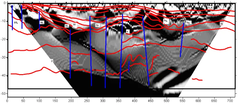
. Like in the method of analytical continuation, the method of wave approximation is applicable to magnetic field reduced to the pole. The combination of considered set of algorithms supposes the correct structural-geological reconstruction (Fig.1).
DISCUSSION
In practice the model of layer-like body (Yu et al., 2007) is considered as optimal one in our problem because:
1. the set of matched layers gives the sectionally smooth structural surface, which is visually estimated as complete object; 2. the particular layer or the set of layers
supposes the reconstruction of the envelope around them and this envelope determines the area of existence of ore object with the average magnetic susceptibility; 3. the solution of inverse problem requires just
information about measured potential field. Its points of extremum specify the initial approximation.
The similarity parameter for comparison of measured and matched fields is quadratic functional of misclosure (Bonnans et al., 2006)
,
where (xi,yj) are the coordinates of pickets within the area of measurements, N is the number of material/magnetized layers, p is the vector of parameters of matched layers. Under the minimization of functional F one needs the reiterated solution of direct problem on each of layers. During this process the graph of F dependence of the number of iteration approaches some global minimum. As a rule, we consider no more than 3000 iterations and after all the algorithm searches the global minimum of F and corresponding number of iteration, parameters of layers, matched field.
The basis of a method is in the expression of gravity potential by Cauchy integral (Cirulsky,
1990; Zhdanov et al., 2010): ,
where
L
is the closed contour (LD,
D
is the finite simply connected domain). Function U
zis divided on two: U
z , analytical inside of L,and U
z , analytical outside of L. These two functions along the contour L do not coincide(L
U U
). For the circle of final radius R inside of which the contour L is
located, U
z is expanded in Laurent seriesR z
, where c0
. Inthis problem we introduce the function z
t for conformal mapping of area D on the unit circle Twith contour L1, along which 1 1
/t t L t
z i
i
i
.
Seeing the agreed notations the nonlinear with regard to z
t integral equation of theoretical inverse problem is written in the form.
Here, studying the singular points which
have the form of ln
za
, for the solution of direct problem we consider the logarithmic class of potentials (Okabe, 1979):- gravity potential;
- magnetic potential,
where [rho] - density, J - the module of magnetization vector, G - gravitational constant,
k
a and bk are the affixes of singular points (tops
of particular layer, which in the plane of cross-section has the form of rod).
CONCLUSION
The algorithms of inverse problem solution with minimizing the number of equivalent solutions by application of mathematically independent recalculations are developed. Practical experience of reconstruction in the regions with different geological structure and tectonic position, has defined the effective combination of five algorithms: the analytical continuation with singularities elimination, calculation of singular points, approximation of measured field by the field of set of density/magnetized layers, transformation of gravity and magnetic fields in wave structure of vertical cross section. In the list of methods the new aspect is the algorithm of nonlinear matching of layered-like bodies, and application of wave analogies as well.
multi-valued character which is defined as solution of “incorrect” problem. One can to decrease the number of possible solutions with application of independent methods: automated fit with simple models, approximations by particular fractions, analytical continuations, wave approximations. The last ones gives explicit structural image of geological media which is confirmed by independent seismic measurements.
The results are supposed to be applied mainly for processing the geophysical data, published in state geological founds. Under minimum of a priori geological information about investigated region the developed approach is able to reconstruct the general structural image of geological cross section with no precise data about real depths and substantial composition. It means our methods could be considered for forward forecast of position of particular geological anomalies, i.e. they require the reference ore objects. Accordingly, there are two immediate problems: development of the set of criteria of geological interpretation of parametric cross sections; to find the correlations between parametric cross sections derived by different methods. The final algorithms are considered to be used for optimization of total volume and, in particular, financial support of detailed surface measurements, applied for verification of the kind of geological anomaly.
REFERENCES
1. Ansari, A.H. and K. Alambar, Reduction to the pole of magnetic anomalies using analytic signal.
World Applied Sciences Journal, 2009; 7(4): 405-409.
2. Bonnans, J.F., J.C. Golbert, C. Lemarechal and C.A. Sagastizabal, Numerical optimization: Theoretical and practical aspects. Berlin: Springer-Verlag, 2006; 494.
3. Cakoni, F. and R. Kress, Integral equation for inverse problems in corrosion detection from partial Cauchy data. Journal of Inverse Problems and Imaging, 2007; 2(1): 229-245. 4. Cirulskyj, A.V., Complex variable functions in
the theory and methods of potential geophysical fields. Sverdlovsk: Ural Department of USSR Academy of Sciences, 1990; 132.
5. Karsli, H. and Y. Bayrak, Application of the normalized total gradient (NTG) method to
calculate envelope of seismic reflection signals.
Journal of Applied Geophysics, 2010; 21: 90-97.
6. Kellogg, H., Foundations of potential theory. Dover Publications, 1953; 379.
7. Luenberger, D. and Y. Ye, Linear and nonlinear programming. Interntional series in operations research and management sience 2008; 116, Springer, pp: 550.
8. Lynn, M.S. and W.P. Timlake, The numerical solution of singular integral equations of potential theory. Journal of Numerishe Mathematik, 1968; 1(11): 77-98.
9. Movchan, I.B. and A.A. Yakovleva, Algorithmization of adaptive filtration of digitized chromatograms. Mining Informational and Analytical Bulletin (GIAB), 2005; 10: 196-200.
10. Okabe, M., Analytical expressions for gravity anomalies due to homogeneous polyhedral bodies and translations into magnetic anomalies. Journal of Geophysics, 1979; 64: 730-741. 11. Roy, K.K., Potential theory in applied gephysics.
Berlin: Springer, 2008; 535-560.
12. Serkerov, S.A., H.A. Elsaed Zeinel’abdein, G.S. Hassan, A.L. Haritonov and G.P. Haritonova, Use of remote sensing data from LadSat-5 combined with the data of surface gravity survey for location of tectonic fractures. Journal of Space Investigation of Earth, 2007; 2: 82-88. 13. Strakhov, V.N., Elimination of dominant pattern
of thinking as a prerequisite for the development of a new paradigm (with special reference to gravimetry and magnetometry). Journal of Physics of Solid Earth, 2002; 3(38): 177-193. 14. Tikhonov, A.N. and V.J. Arsenin, Methods of
solution of ill-posed problems (2nd ed.). Moscow: Nauka, 1979; 284.
15. Wolters, C.H., H. Köstler, C. Möller, J. Härdtlein and A. Anwander, Numerical approaches for dipole modeling in finite element method based source analysis. 15th International Conference on Biomagnetism (vol. 1300), Vancouver, BC, Canada, 2007; 189-192.
16. Yu, P., J.L. Wang and J.S. Wu, An inversion of gravity anomalies by using a 2.5 dimensional rectangle gridded model and the simulated annaeling algorithm. Chinese Journal of Geophysics, 2007; 3(50): 756-764.