From Development to Implementation of Hazard Mitigation Plans:
Importance of Intergovernmental Relations, Citizen Participation and
Integration of Hazard Mitigation in Local Comprehensive Plans
by
Sayuri Terashima
A Masters Project submitted to the faculty of the University of North Carolina at Chapel Hill
in partial fulfillment of the requirements for the degree of Master of Regional Planning in the Department of City and Regional Planning.
Chapel Hill
2008
Approved by:
_________________________ ______________________
Abstract:
This paper investigates several factors that allow local governments to move from development to implementation of their hazard mitigation plans. While guidelines exist on creating good quality hazard mitigation plans, there are no such conclusive findings for actually executing the actions identified in these plans. Specifically, this paper examines the role of three factors in being able to more effectively implement the plans. First, it explores the role of the nature of intergovernmental relations among the administrators involved in the Hazard Mitigation Grant Program in being able to successfully elevate structures or acquire properties. Second, it investigates the role of stakeholder participation in the hazard mitigation plan development process and its relationship with a good quality plan. Thirdly, it investigates the degree of integration of hazard mitigation in local land use plans. The study methodology includes a survey of the administrators of HMGP, and evaluations of the plans by using a plan evaluation protocol. The study is conducted for three counties in eastern North Carolina: Dare, Hyde and Pamlico. Findings indicate that high levels of trust and involvement of the administrators is a prerequisite to being able to successfully implement grant funds to remove people permanently out of harm’s way. Furthermore, it is found that planner involvement in the hazard mitigation plan development process is important, not only to incorporate more stakeholder involvement, but also to make the link between the policies in the plans with land use management tools that are identified in comprehensive plans and used daily by local decision makers.
TABLE OF CONTENTS
I. INTRODUCTION...4
II. HISTORY OF HAZARD MITIGATION POLICY FOCUSED ON FLOODS...6
III. MULTILEVEL GOVERNANCE: POLICY FORMULATION AND IMPLEMENTATION ...10
A.INTERGOVERNMENTAL RELATIONS...10
B.MULTILEVEL GOVERNANCE FOR HAZARD MITIGATION...11
C.TRUST AND POLITICS OF IMPLEMENTATION OF HAZARD MITIGATION POLICY...12
IV. PUBLIC PARTICIPATION IN HAZARD MITIGATION PLANNING ...15
V. INTEGRATION OF HAZARD MITIGATION PLAN IN COMMUNITY COMPREHENSIVE PLANS .17 VI. STUDY METHODOLOGY ...18
A.INTERGOVERNMENTAL RELATIONS...18
B.CITIZEN PARTICIPATION IN HAZARD MITIGATION PLAN DEVELOPMENT...19
C.INTEGRATION OF HAZARD MITIGATION IN LAND USE PLANS...19
D.STUDY SITES:...20
Dare County: ...21
Hyde County: ...23
Pamlico County: ...24
VII. MAJOR FINDINGS ...26
A.INTERGOVERNMENTAL RELATIONS FOR HAZARD MITIGATION IN NORTH CAROLINA...26
Perceptions of Grant Administrators ...26
State Involvement and Initiative in Local Hazard Mitigation Plan Development...28
Summary of Perceptions about Intergovernmental Relations...30
VIII. CITIZEN PARTICIPATION IN HAZARD MITIGATION PLAN DEVELOPMENT ...31
GENERAL FINDINGS...31
Citizen Participation in Hazard Mitigation Plan Development in Pamlico County:...32
Citizen Participation in Hazard Mitigation Plan Development in Dare County:...33
Citizen Participation in Hazard Mitigation Plan Development in Hyde County:...34
IX. EVALUATION OF INTEGRATION OF HAZARD MITIGATION IN LAND USE PLANS ...35
OVERVIEW OF THE DEGREE OF INTEGRATION...36
A. Degree of Integration in Dare County...37
B. Degree of Integration in Hyde County...40
C. Degree of Integration in Pamlico County ...42
From Development to Implementation of Hazard Mitigation Plans:
Importance of Intergovernmental Relations, Citizen Participation and
Integration of Hazard Mitigation in Local Comprehensive Plans
I. Introduction
Natural hazards continue to cause economic and life losses all around the world despite
the advancement in technology and numerous compiled documents of lessons learned. Floods in
particular have on average caused economic losses of $6 billion annually in the United States
(USGS 2006). Costs of responding to and recovering from disaster are also on the rise. Although
the loss of life due to floods has been declining, economic losses due to floods have continued to
rise because of increased development in the flood-prone coastal areas. Furthermore, these
hazards have consequences on political and socio-cultural realm, as people are displaced from
their homes, and conflicts arise in responding to hazards. When hazards are not mitigated and
response is not managed well, the loss of property and life increase, causing natural disasters, as
was recently seen in the case of Hurricane Katrina.
Hazard mitigation occurs within the process of disaster or emergency management. The
community must recognize the hazards that exist in the community then prepare a plan to
minimize the damage from hazards and avoid hazards from becoming disasters. Even if the plan
is prepared if it is not implemented then it does not help the citizens in the community. Aside
from preparing for disasters, emergency management involves supporting and rebuilding
communities during and after the disasters. Successful prevention of loss of life and property
comes only as a result of coordinated actions on the part of many agencies to implement the
plans that have been prepared and accepted by people in the community.
Hazard mitigation planning process itself is also conducted under shared governance with
multiple stakeholders, which makes the implementation of the hazard mitigation plan very
difficult. While FEMA stated in 1995 that “all mitigation is local,” it has been found that
disasters have a low salience at the local level not only on public officials but also on the public,
until they happen (Rossi et al 1982). Although local governments have the knowledge of their
At the same time, hazard mitigation at the local level occurs within the intergovernmental
framework. Federal and State governments have an important stake in promoting hazard
mitigation as the cost of reconstruction from damages due to disasters have been on the rise
(Burby et al., 1991). Hazard mitigation planning can lead to many benefits, including cost
savings involved in response and recovery, prevention of loss of lives and property and reduction
of future vulnerability through wise development, or redevelopment. Federal and State
governments thus make funds available for local governments to include hazard mitigation
planning feasible in the communities. However, these programs can be driven by the politics
surrounding the situation, and may not objectively analyze the potential losses from hazards, or
benefits from mitigation (May 1997).
Combined, these issues at the local, state and federal level lead to the “commitment
conundrum” to mitigate against natural hazards effectively (Burby et al. 1998, May et al. 1996).
A community must not only be able to get the buy-in from the local citizens who will demand
that their local politicians will pay more attention to this issue. In addition to that, the local actors
must weave through a web of intergovernmental relations to be able to receive the funding
needed and to implement the projects identified on their local hazard mitigation plans. Because
of the complexities involved, communities that are actively involved in hazard mitigation and are
willing to persevere tend to be those that are likely to be regularly threatened by such hazards
and know their damaging power (Burby et al., 1982).
This research project studies three counties in North Carolina (Dare, Hyde and Pamlico)
that have had varying degrees of success in hazard mitigation. It investigates the level of citizen
involvement in hazard mitigation plan making, the intergovernmental relations among the
different levels of government, and the integration of hazard mitigation in comprehensive plans.
Section II provides a brief overview of flood control policy in the United States, Sections
III, IV, and V document existing literature and theory on intergovernmental relations,
participatory planning and integration of hazard mitigation in comprehensive plans. Section VI
describes the study methodology, and sections VII through IX present the study findings. Section
II. History of Hazard Mitigation Policy Focused on Floods
The approach at the federal level to reduce loss from natural hazards, particularly from
floods, has gone through some major changes in the United States. For much of twentieth
century, efforts were focused on using structural controls such as levees and dams to contain
floods. The structural controls, in addition to being very expensive, were criticized as providing
citizens a false sense of security; communities kept on building in areas that face the risk of
being heavily flooded (White 1945; Burby et al. 1985; Burby et al. 1988). From the 1960s,
especially after the creation of the National Flood Insurance Program in 1968, federal policy
shifted to focusing on building regulations through land use controls and insurance. However,
because NFIP did not require adoption of these land use controls to steer development outside of
the floodplain, and because these flood insurances were cheap to obtain, it has also been
criticized for facilitating development in the floodplains (Burby and Kaiser 1987).
Currently, since the 1990s after the passage of the Stafford Act, the federal government
has entered the “mitigation era” (Godschalk et al., 1999). Hazard mitigation is focused on
removal of existing structures out of the floodplains to get people permanently out of harm’s way.
Unlike the previous approaches to hazard mitigation, the recent approach has the potential to
minimize damages and loss in property and life by limiting development in the floodplains. The
Robert T. Stafford Disaster Relief and Emergency Assistance Act (Stafford Act), signed into law
in 1988, is designed to “provide an orderly and continuing means of assistance by the Federal
Government to State and local governments in carrying out their responsibilities to alleviate the
suffering and damage which result from (…) disasters” (FEMA, 2007). This Act was last
amended in June 2007. The Act consists of various sections, each addressing how the national
government would be involved in the different phases of disaster management, including disaster
preparedness and mitigation, response and recovery. The Stafford Act authorized several grant
programs. Among these programs are:
• Pre-Disaster Mitigation Program, which provides the States funding for planning
activities to raise risk awareness and to reduce losses before disasters;
• Hazard Mitigation Grant Program (HMGP), which provides States with grants for long-term hazard mitigation projects after major disaster declaration.
These programs gained attention from both the Federal and State officials during the late 1980s,
after numerous flooding occurred in the Midwest and around the country. The HMGP projects
are now utilized to provide a long-term solution to a problem. Some examples of projects funded
under HMGP include:
• Elevation of flood prone structures;
• Development and initial implementation of vegetative management programs;
• Voluntary buyout of real property for willing sellers and demolition or relocation of
buildings to convert the property to open space use;
• Retrofitting structures and facilities to minimize damages from high winds, earthquake,
flood, wildfire, or other natural hazards.
These grants are provided by FEMA to eligible States, Tribes, or Territories. The States
select and prioritize the applications that are submitted to them by the local jurisdictions and
submit them to FEMA. In North Carolina, the Division of Emergency Management (NCDEM) is
responsible for securing grants from FEMA for the local jurisdictions, and administering the
HMGP. During the recovery phase of a disaster, the local jurisdictions choose projects identified
in their mitigation plan that meet the requirements of HMGP and submit grant applications to the
State. NCDEM staff help the local governments to develop the applications, and submit them to
FEMA. Once the projects are approved, the local government contracts with the State and
receives reimbursement from the State for activities related to the project. HMGP is a cost-share
grant in which up to 75% is contributed by FEMA, and the rest are paid for by the local
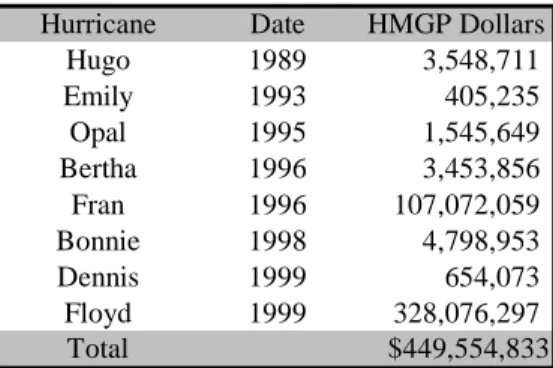
government. Table 1 shows the amount that has been disbursed after each of the major
presidentially declared hurricanes. An impressive $450 million had been spent to mitigate
hazards. Not only does this figure reveal the assistance given to counties, but at the same time, it
Table 1: Hurricanes Affecting North Carolina and HMGP Spending
Hurricane Date HMGP Dollars Hugo 1989 3,548,711 Emily 1993 405,235 Opal 1995 1,545,649 Bertha 1996 3,453,856 Fran 1996 107,072,059 Bonnie 1998 4,798,953 Dennis 1999 654,073 Floyd 1999 328,076,297
Total $449,554,833
Data Source: NCDEM and FEMA, “Mitigation Preliminary Performance Assessment.”
http://www.dem.dcc.state.nc.us/Mitigation/Library/Success_Stories/Perf%20Assessment%20NC%20Print.pdf
Requirements to receiving HMGP funds were amended in 2000 by the Disaster Mitigation
Act of 2000 (DMA 2000). DMA 2000 repealed some previous mitigation planning provisions
(Section 409) and replaced them with a new set of requirements (Section 322). Through this
amendment, Section 322 prescribes new and revitalized approaches to hazard mitigation
planning and emphasizes the need for state, tribal, and local entities to “closely coordinate
mitigation planning and implementation efforts” (FEMA, 2008). DMA 2000 made the approval
and update of local hazard mitigation plans as a prerequisite to receiving post-disaster HMGP
funds after November 1, 2004. These plans must identify and prioritize the hazards, assess the
community needs and describe a community-wide strategy for reducing risks that are associated
These local plans are also compared against the State’s Hazard Mitigation Plan to make sure
that the priorities identified in the plan are in agreement and consistent throughout the State
(FEMA, 2007). To date, 183 local single and multi-jurisdictions, including towns, cities, and
counties within North Carolina have a current plan approved by FEMA and adopted by local
governments (NCDEM, 2007).
Having a hazard mitigation plan is only a start; the counties must implement these hazard
mitigation plans in order to effectively prepare for and mitigate hazards. Of those 183
jurisdictions in North Carolina that have a FEMA approved local hazard mitigation plan, about
50 of them have applied for the HMGP funds. It could be the case that the other 133 jurisdictions
did not experience Presidential Declared Disasters, or that they did not identify hurricanes and
floods as a major hazard in their jurisdictions. However, even if these jurisdictions did not
receive funding to try to more permanently reduce risk from floods, they still face the risk of
property and life loss. Therefore, these jurisdictions still must complement their activities in the
“mitigation era” with those related to the previous era, by using land use controls.
There are many reasons for not being able to effectively obtain funds from HMGP and
implement the actions identified in the local mitigation plans even in communities where
flooding is identified as a major hazard. For example, the idea of restricting property use to
decrease the impact from floods is politically explosive. Older parts of communities tend to lie in
the floodplain, and the percentage of minority residents in those neighborhoods tend to be high.
Officials have been accused of engaging in racial discrimination when trying to remove these
residents from the floodplains (Fraser et al, 2003). Some towns also worry about losing tax base
if community members decide to participate in the acquisition program and move outside of the
Disaster Management Act 2000 SEC. 322. Mitigation Planning
(a) Requirement of Mitigation Plan—As a condition of receipt of an increased Federal share for hazard mitigation measures under subsection (e), a State, local, or tribal government shall develop and submit for approval to the President a mitigation plan that outlines processes for identifying the natural hazards, risks, and vulnerabilities of the area under the jurisdiction of the government.
Some counties are able to work through these difficulties and are able to use HMGP funds to
elevate structures or acquire property in the floodplain. Other counties, while they may not be as
successful in permanently removing structures from harm’s way are successful at integrating
hazard mitigation in land use planning. This research project is an attempt to uncover some of
the factors that help communities to mitigate hazards both through the use of HMGP funds to
elevate structures or to acquire property, and by actively using land use management tools.
In the following sections, I note how intergovernmental relations particularly among grants
administrators, citizen participation in the hazard mitigation planning process, and integration of
hazard mitigation in land use plans have contributed to reducing the risk of property and life loss
to communities.
III. Multilevel Governance: Policy Formulation and Implementation
A. Intergovernmental Relations
One of the major difficulties in protecting property and life from natural hazards lies in
coordinating the relationships that exist among the different layers of government in formulating
and implementing policies. The term intergovernmental relations (IGR) has been used to
describe the numerous combinations of the influences and interdependencies of the elected and
appointed public officials at different levels of governmental units who are jointly responsible
for policy issues. As a term, IGR originated in the 1930s when New Deal and its comprehensive
efforts to deal with the economic and social impact of the Great Depression was introduced
(Wright, 1997).
IGR has gone through phases characterized by different problems and approaches to
mechanisms for operating. For example, a phase very relevant to the current IGR in hazard
mitigation (the period between 1950s and 1960s) is known as the creative phase that was
characterized by three IGR mechanisms (Wright, 1997). First, this period was the beginning of
program planning, where the national legislative and administrative requirements stated that
comprehensive local, area-wide or statewide plans to be submitted and approved before
receiving grant funds (Advisory Commission on Intergovernmental Relations, 1961). Second,
participation introduced an element of client involvement in program operations and
administrative decisions. Phrases such as “maximum feasible participation” were inserted into
the legislation around this time, to increase the economic opportunities of the minorities and
economically disadvantaged (Wright, 1997).
This creative period in IGR, as well as all periods preceding and following it, have
influenced the current IGR. When we examine this IGR in the context of hazard mitigation, it is
clear that there are grants administrators involved at the local, state, and national level who
implement the HMGP. It can then be said that the relationship between these grants
administrators is very important in the success of its implementation. Furthermore, in general, in
IGR, it has been said that the participants’ perceptions of each other are important factors in
daily operations. The role of public participation and the public’s involvement in program
operations and administrative decisions has also been emphasized through the DMA 2000 as
well.
Intergovernmental Management is a relatively new term (1970s) that is also relevant to
hazard mitigation. It is the process of problem solving through the use of collaborative networks
composed of governmental and nongovernmental actors. Implementation of programs that span
multiple jurisdictions involve networking and negotiating with these actors. Both program and
policy professionals are the leading actors, and authority among the actors is perceived to be
non-hierarchical. Governance involves “managing networks” (Rhodes, 1996) and conflicts are
likely settled through discussions, negotiations and dispute settlements.
B. Multilevel Governance for Hazard Mitigation
While some researchers have concluded that the nature of IGR is the main determinant of
successful policy implementation (Stratton, 1989), to date, not much research has been done on
the role of intergovernmental working relationships on implementation patterns of hazard
mitigation plans. In disaster response system implementation, it has been found that policy
implementation requires a bargaining model, which involves negotiation and bargaining among
the local, state and national government officials that all bring their own resources, motivations
and effort (Stratton, 1989). The failure of implementation of plans, such as in the case of
among the participants, which led to the slow response (Ink, 2006). The White House report on
lessons learned from Katrina notes several flaws in national preparedness, one of which is
insufficient regional planning and coordination (Townsend, 2006). What is the condition under
which effective coordination, as well as bargaining can take place?
To answer this question in the context of hazard mitigation, Scheberle, a professor of
political science at the Department of Public and Environmental Affairs explores the premise
that “positive relationships between federal and state facilitate implementation of environmental
programs” (2004). Her premise is based on the view of Deil Wright (1982):
“Strictly speaking, then, there are no relationships among governments; there are only relations among officials who govern different units. The individual actions and attitudes of public officials are at the core of IGR. Their behavior is
purposeful—for example, to obtain a grant or provide a program. And their actions are heavily influenced by how they perceive other participants’ actions and attitudes.” (11)
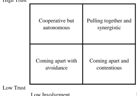
C. Trust and Politics of Implementation of Hazard Mitigation Policy
Scheberle posits that there are two characteristics of working relationships among these
officials who govern at different units that are most critical to predicting whether federal and
state officials will respond positively to each other: mutual trust and the extent of involvement by
oversight personnel. Using these two characteristics, she details four different typologies of
Table 2: Typology of Federal and State working Relationships
High Trust
Cooperative but autonomous
Pulling together and synergistic
Coming apart with avoidance
Coming apart and contentious
Low Trust
Low Involvement High involvement
Data source: Denise Scheberle: Federalism and Environmental Policy (p22)
A productive relationship is characterized by the individuals involved feeling that the
other parties involved are as dedicated and care about achieving the same goal. The involved
parties care about the outcome as well as the process. Normally, high level of trust is seen as a
contributor to allowing this type of relationship to grow. Where high levels of trust exist, there is
likely to be more sharing of information, respect for each others’ actions, and flexibility in the
program implementation. The other aspect, the extent of involvement, may include formal or
informal communication among the staff at different levels of government, as well as sharing of
resources and giving technical advice. However, unlike trust, a higher level of involvement by
oversight personnel is not necessarily good, as it limits the freedom of the localities to make their
own decisions, and may give them the wrong idea that they may be being micromanaged.
In a working relationship characterized by high trust and high involvement by oversight
personnel, parties “pull together” and “synergize” to see the project through to implementation.
The overseers recognize the abilities and the dedication of the state and local administrators and
sincerely care about the success of the implementation efforts. The administrators at the state and
local level in return also see the abilities and dedication of the federal staff and there is a
relationship, staff at all levels assist each other, giving each other technical assistance,
consultation, and logistical support in addition to financial support.
Where there is high trust but low involvement, Scheberle notes that the working
relationship is cooperative but autonomous. The parties involved do respect each other, but give
each other space and have less interaction with each other. Communication may not be as
frequent and thus there may be misunderstanding or duplication of efforts. The state or local
level staff do not know what is going on at the federal level, and vice-versa, and support that can
be helpful for implementation is not provided to the extent possible under a synergistic
relationship. As the parties do not really understand the activities of the other parties, program
implementation is less effective. When communication does occur, it is open because the parties
do trust each other. When there is goodwill but resources are lacking, relationships tend to fall in
this category.
When the relationship is characterized by low levels of trust and low levels of interaction,
the relationship is coming apart with avoidance. The parties do not care to understand each
others’ situations or motivations and operate on their own. Communication and sharing of
information happens minimally just to meet the statutory requirements. As the administrators are
not cohesive, they are less likely to be champions of the cause, and thus causes supported by this
type of working relationship is likely to fall apart during times of fiscal austerity.
The last type of working relationship is characterized by the presence of little mutual trust
and high levels of involvement. In this situation, staff at the lower levels of government are
likely to feel that they are being micromanaged because of the level of attention that the other
parties pay to the wrong activities. These activities may include administrative details, like filling
out paperwork, program reviews, or organizational outputs. This may result in the local
participants to pretend to comply, while on the ground, running the program as they wish. They
may also hide information that may be helpful for the other parties because they think that the
other parties may use the information to their disadvantage. Communication does not happen
regularly, and when it does, it is not characterized by trust; some participants may be so
frustrated that their communication may be dishonest. This relationship is very frustrating as
IV. Public Participation in Hazard Mitigation Planning
Aside from the governance issue, the role of public participation has been known to
affect the outcome of the hazard mitigation programs (Fraser 2003, Pearce 2003). Local
officials’ opinions about public participation in the planning process to mitigate hazards have
changed in the past. Citizens have been seen as subjects, and target of programs aimed at
protection. There are those who view the citizen participation in the entire planning process,
starting from goal setting and information gathering to analysis and decision making about
priorities to the community, proceeding through program implementation along with monitoring
and evaluation as being important to successfully achieve hazard mitigation. However, in areas
such as hazard mitigation which tend to be very technical, obtaining such participation can be
hard (Pearce 2003). Furthermore, depending on the situation, public participation has been seen
to contribute to the problem, rather than to aid in the solution (Dorcey and McDaniels 1999).
In hazard mitigation planning, politics have influenced how much the public knew about
the issue and how much the public participated in the process. Local officials have hesitated to
reveal to the public the risks and danger that they can be exposed to. It has been found that even
when the public would welcome the local governments’ efforts to educate them on hazards that
threaten them, local governments very seldom attempt to do so (Aguirre 1994; Drabek, 1986).
One of the many reasons for the local officials’ hesitance to do so is that if people moved out of
the jurisdiction upon finding out the risk, that could mean a possible loss of tax base for the
community. The public can panic, or seek to attain a consensus on every issue, stalling the
planning process (Pearce, 2003). Recently, changes have been made and local officials are
increasingly providing more information about hazards as the citizens have become more
interested in participating more actively.
Mere information provision has been found to not be enough to ensure a successful
implementation of the plans, however. Community members at times demand direct participation
in the policy making process, increasingly voice frustration at being excluded from the planning
process (Fraser et al, 2003). Fraser et al also suggest that more effort be focused on making the
buyout process participatory, so that residents are able to have more meaningful input throughout
the buyout process. It has been suggested that communities must do more to involve the citizens
the disaster management process (Pearce, 2003). The degree to which citizens have bought into
the purpose of the hazard mitigation programs, such as property elevation or acquisition, have
been found to influence the success of the implementation (Fraser et al, 2003, McCann 2006). It
has been also said that the participatory process itself may be as important as the outcome
(Mileti, 1999).
How can communities effectively integrate public participation? Many models of
participation in decision making process have been proposed (Creighton 1992, Godschalk et al
1994). A commonly used model is that which consists of a central planning committee with
several subcommittees organized by geographic hazard area, or by mitigation strategies
(Godschalk et al 1998). Beyond these models, there are techniques to integrate citizen
participation, including holding charettes, focus groups, interviews, public hearings, community
meetings and workshops, as well as electronic town meetings, and establishing hot lines and
comment boxes for people to leave their opinions. In order to make these citizen participation
meaningful, it has been found that these actions must be reinforced by overall support from the
high levels of government that encourage community commitment to disaster planning (Berke et
al 1994).
There are many factors that can influence the outcome of land use management or hazard
mitigation that can be gathered by including citizens in the planning process. For example,
researchers have investigated the importance of risk that citizens feel in moving to other
neighborhoods, such as losing their social networks, or being able to pay another mortgage.
Another important factor is the attachment of the citizens to their neighborhoods. These factors
are found to play an important role in convincing the citizens to participate or not in property
acquisition programs (Fraser et al, 2003). Furthermore relocation decisions have been shown to
be predicted by residential satisfaction, as well as neighborhood ties. However, if the citizens are
not involved in the hazard mitigation planning process, the staff will not be able to cater the
strategies and policies of the locality to best serve the needs of their citizens. These factors, while
important, are not investigated in this study.
V. Integration of Hazard Mitigation Plan in Community
Comprehensive Plans
While the discussion thus far has focused on acquisition programs and elevation of
structures utilizing funds from HMGP, the techniques used in the previous ‘eras’ of flood
damage reduction, such as the land use management tools, are still useful. In pursuing this route,
a relevant question to ask the planner and community is their choice in approach to drafting the
hazard mitigation plan. For example, the planner and community have a choice to make the
mitigation plan to be a separate, stand-alone plan, or a part of a comprehensive community plan.
Godschalk et al recommend that in certain cases where the community has no comprehensive
plan or where it is weak, or out-of-date, or when the hazard mitigation issue is high on the
community agenda, that the communities prepare a stand-alone mitigation plan. They also
recommend incorporating the mitigation plan into a comprehensive plan because the
comprehensive plan “already has standing in the community as a policy guide, and the
comprehensive plan encourages integration of mitigation goals and programs with other ongoing
community goals and programs” (p101).
In the recent context of the requirements imposed by DMA 2000 to prepare a separate
local hazard mitigation plan, it necessarily implies that communities that wish to receive federal
funding assistance will have to prepare a stand-alone mitigation plan. While mandates such as
these give a special opportunity to commit to developing a mitigation plan with a strategy, all of
the time, money and efforts can be wasted if no further effort is made to continuously implement
the strategies identified in these stand-alone mitigation plans. Godschalk et al recommend that
because many elements of the hazard mitigation strategy are land-use related, the stand-alone
plans be eventually integrated in the comprehensive land-use planning process to ensure
implementation (1998). Many research findings conclude that communities’ comprehensive
plans can promote the use of best hazard mitigation practices by incorporating specific hazard
mitigation goals, objectives and policies to mitigate impact from floods (Chapin and Kaiser,
VI. Study Methodology
The study design included three separate components. The first component is the analysis
of the intergovernmental relations among the individuals involved in administering the Hazard
Mitigation Grant Program at the county and the state level. The second component is the
evaluation of citizen participation in the hazard mitigation plan development process. The third
component is the evaluation of the integration of hazard mitigation into comprehensive land use
plans.
A. Intergovernmental Relations
In order to gauge what the intergovernmental relations were like between the grants
administrators, several approaches were used. First, brief research was conducted about
programs that exist within North Carolina that could potentially influence the level of interaction
and cooperation among the officials at different levels of government, particularly within the
hazard mitigation realm.
Second, a survey was conducted to qualitatively analyze the county’s responses to
questions related to the nature of intergovernmental relations. The survey asked a series of
questions about the respondents’ frequency of contact with government officials at different
levels, their perception of the officials at other levels of government, and their opinions on the
most important factors for successful implementation of projects identified in the mitigation
plans. For example, a question asked the respondents to rate the level of trust he or she has for
officials at different levels of government he or she interacts with throughout the HMGP process
on a scale of 1 to 10, with 10 being “completely trusting.”
These surveys were sent to local government staff who were identified as having been
involved in the hazard mitigation process as well as involved with HMGP and included those in
emergency management and planning. Initially, the survey was sent to those who were identified
in the hazard mitigation plans, but as it was found that there has been significant turnover in staff
in these offices, the current administrators were also contacted. At the state and federal level, the
survey was sent to several staff in the Hazard Mitigation Team and Department of Homeland
respondents nor their specific responses are disclosed in this report. A copy of the surveys that
were sent to the respondents are available in Appendix A.
B. Citizen Participation in Hazard Mitigation Plan Development
In order to evaluate the extent of citizen participation in hazard mitigation plan
development, I used an existing protocol for evaluation of the quality of the hazard mitigation
plans (Godschalk et al., 1998). The actual questions used to evaluate citizen participation are
included in Appendix B. Six indicators to measure the quality and documentation of citizen
participation methods were used. The component was given a “0” if the principle was not
identified in the plan, a “1” if it was identified but was vague, and a “2” if it was identified and
was very clearly stated. The sum of the scores indicate how thorough each county’s hazard
mitigations were in addressing who was involved in the planning process, how, and why they
were involved.
C. Integration of Hazard Mitigation in Land Use Plans
A systematic evaluation of the natural hazard mitigation elements was conducted in the three
counties’ comprehensive land use plans. The methodology used is derived from the detailed plan
evaluation protocols that have been designed specifically for the evaluation of flood mitigation
techniques. This was done to see the degree to which each jurisdiction incorporated the
mitigation plan’s strategies into other planning documents. This approach was taken because the
external indicator that was used, the amount of funding received from HMGP and the number of
homes elevated or acquired, is not the only indicator for successful implementation of the hazard
mitigation plan. The protocol used builds on the existing protocols for the evaluation of flood
mitigation in comprehensive plans (Berke and French, 1994, Godschalk et al., 1998, 1999; Berke
et al., 1999; Brody, 2003, Srivastana and Laurian, 2006). Similar to these previous studies, I
evaluate flood mitigation through the comprehensive plans based on three major factors
including:
o Fact basis;
o Inclusion of goals and objectives to mitigate flood hazard; and
The evaluation protocol used for this study includes 52 indicators. The factual basis evaluates
two main themes including identification of the hazard as well as the assessment of risk and
vulnerabilities, measured by 10 indicators, including the number of population, critical facilities
and values of private property exposed to the hazard. The inclusion of goals and objectives
evaluates the identification of goals related to three main themes: minimizing economic and
environmental impacts of hazards as well as general goals to promote the safety of citizens. This
is measured by 8 different indicators. The policies evaluation section includes the identification
of seven themes including interagency coordination, awareness building, development controls,
incentives, hazard controls, recovery measures and emergency preparedness. The complete list of
indicators used to evaluate the plans is included in Appendix C.
Three comprehensive land use plans of the counties were evaluated using this protocol and
52 indicators. The component was given a “1” if the facts, goals or policies were mentioned in
the plan, and “0” if they were not identified in the plan. For each component and theme
evaluated, subtotal scores were calculated. These scores reveal the variety of methods that
comprehensive plans have used to integrate hazard mitigation. The scores do not however
indicate the quality or the implementation of the strategies. One can only assume and hope that if
the plans had a higher score in these themes, that it is more likely that hazard mitigation issues
identified in detail in the hazard mitigation plans are being implemented through the integration.
D. Study Sites:
This research project involved conducting a focused investigation of three jurisdictions in
North Carolina in the eastern coast: Dare, Hyde and Pamlico Counties. A map showing the
location is included in Appendix D. The three jurisdictions were chosen based on their
similarities in terms of location and likelihood to suffer from hurricanes and flooding. The
counties also have a history of experiencing the same hurricanes that were declared presidential
disasters. These hurricanes include Hurricane Ophelia in 2005, Hurricane Isabel in 2003,
Hurricane Floyd and Dennis in 1999 and Hurricane Bonnie in 1998 (FEMA, 2008). Because they
have suffered similar impacts, and as the President declared these hurricanes as major disasters
and designated all three of these counties eligible for federal funding, they are under comparable
Hatteras Village, Dare County, after Hurricane Isabel in 2003. Photo Source: FEMA
varied. As can be seen in the table below, Hyde County has by far been successful at getting
HMGP funds to elevate structures and to acquire property from floodplains.
The intent is to investigate whether differences in participation of citizens in the hazard
mitigation plan development, the nature of intergovernmental relations among the officials
involved in the hazard mitigation planning process, as well as administering of HMGP funds,
and the extent of integration of hazard mitigation into the comprehensive land use plans made a
difference in successfully removing people out of harm’s way through property acquisition.
Dare County:
Dare County consists of
unincorporated portions (Hatteras Island,
the Mainland, and the portions of
Roanoke Island) as well as incorporated
areas, whch include six municipalities
(Town of Duck, Town of Kill Devil
Hills, Town of Kitty Hawk, Town of
Manteo, Town of Nags Head and Town
of Southern Shores). These
municipalities are responsible for their
own planning and building inspections,
and the Dare County Planning Department is responsible only for the unincorporated portions.
The most current population estimates for the total permanent population in the unincorporated
area is 34,674 (July 2006, North Carolina State Demographics). Of the three counties studied,
Dare County has the most population. Its most current Multi-Hazard Mitigation Plan is in a draft
form, adopted by the county in November, 2004.
According to the Multi-Hazard Mitigation Plan, the county has about 850 buildings that
participate in the NFIP in 10 flood prone areas. Most of the land in Dare County is subject to
inundation with category 1 storms (Appendix E). The County has had an extensive hurricane
history. Recently, in 1999, Dare County was affected by Hurricane Floyd. Although this
Kitty Hawk, Dare County. Waterfront Property suffers damages from floods after Hurricane Isabel in 2003. Photo Source: FEMA
deaths , and in North Carolina alone, 7,000 homes were uninhabitable, with another 56,000
homes damaged. The damage in Dare County was mostly from soundside flooding and fallen
trees. The figure quoted in Dare County’s Mitigation Plan for the damage is around 4 million
dollars in property damage. At least 17 structures were destroyed or uninhabitable. 39 structures
within Dare County had major damage, and about 950 more suffered minor damage (Dare
County, 2004).
The County was hit hard again in
2003 with Hurricane Isabel, when
more than 60 properties in the
village of Hatteras were destroyed.
Isabel formed from a tropical wave
on September 6, 2003, and made
landfall on the Outer Banks of
North Carolina on September 18.
Isabel caused damage across
eastern North Carolina, estimated
to be around $450 million. The
storm surge in Dare County made a 2,000 foot wide inlet on Hatteras Island, inundating the roads
and isolating Hatteras by road for two months. The Strong winds downed many trees, leaving up
to 700,000 residents without power for a few days.
In a study that was conducted with residents of Dare County, it was found that most
considered Hurricane Isabel a particularly severe and memorable storm. One person is quoted as
saying “Those who never left before now leave after experiencing Isabel” (Ward et al., 2007).
Plans are for Dare County to elevate 32 structures; Dare County is approved to receive around
2.6 million dollars from HMGP.
Out of the three study sites, there was least turnover in employees involved in hazard
mitigation in Dare County, from the time the hazard mitigation plan was written until today. The
Planner has worked with the county for 10 years and has noted that the county officials and
After Hurricane Isabel: A house in Hyde County that was elevated was not flooded, while a neighboring non-elevated house suffered from flooding. Photo Source: FEMA
12 homes that were approved for elevation dropped out for several reasons, but the effort has
been increasing in the county to mitigation staff. Recently, county officials have established a
mitigation department, and has placed responsibility and confidence in staff to implement
HMGP. The County has been able to maintain a database of homes that are risk prone, and have
continued to search for different types of funding to reduce the exposure to future flooding
events.
Hyde County:
Hyde County is located in the
northeast coast of North Carolina,
neighboring the Atlantic Ocean. Ocracoke
Island is the county’s most popular tourist
destination. The most current population
estimates the total permanent population to
be 5511 (July 2006, North Carolina State
Demographics). All of Hyde County is in
an area that is prone to effects of hurricanes
and tropical storms When FEMA updated
the Flood Insurance Rate Maps in 2002,
92% of Hyde County and 99% of Ocracoke Island were identified as being in the Special Flood
Hazard Area (SFHA) (Hyde, 2007). These are areas with a 1% or greater chance of flooding in
any given year, and are also commonly known as the floodplain (Appendix F).
According to FEMA’s definition, there are 52 “repetitive loss properties” in Hyde
County. There are hundreds of other structures in the county that have suffered repetitive flood
losses, but they do not meet FEMA’s definition and therefore do not qualify for elevation of
acquisition. To date, funds have been authorized through the HMGP to elevate 37 and to acquire
21 residential structures. The county has suffered from multiple major hurricanes, including
Hurricane Bonnie in 1998, after which about 39 homes were eligible to be elevated. However,
due to issues arising with the process, the elevations did not occur until after Hurricane Floyd in
Hurricane Floyd; although the county started to provide information about HMGP after
Hurricane Bonnie, staff level was still limited. FEMA and NCDEM held public meetings with
county officials immediately following Hurricane Floyd where it was decided that the State of
North Carolina implement a Crisis Housing Assistance Fund (CHAF) to “help homeowners and
involuntary displaced renters whose primary residence was damaged or destroyed” (SBTDC,
2005). After Hurricane Floyd, the homes were torn down instead of elevated, and replaced with
modular units.
Hyde County Planning Department is currently run by one person who also acts as the
County’s Economic Developer. The local government had been overwhelmed by the amount of
destruction that has occurred after the major hurricanes, especially its County Manager also was
carrying out the duties of an emergency manager. Since the addition of a new full-time
emergency manager, as well as contracting with a consulting firm, the county government is a
little less limited in terms of staff capacity. After these changes, however, staff have been very
proactive in helping to advertise the HMGP, and to take inventory of housing stock that need to
be improved.
Even with these improvements and additions in staff, the staff capacity is not nearly
enough. After Hurricane Isabel hit in 2003, the citizens, county staff, volunteers within the
county worked together to handle the situation. Virtually every building in Swan Quarter was
flooded, and in Englehard, 75% of the buildings were flooded (Brown, 2003). The county relied
heavily on state and federal officials, as well as elected officials, church groups, and nonprofit
organizations to recover from the flooding that happened. These major disasters are not enough
to make the residents leave the area; most of the citizens are described as wanting to remain in
Hyde County. The local government at the same time also wishes to keep them for tax collection
purposes. Survey response indicates that mitigation is encouraged by “building codes,
enforcement of flood zone policies, etc.”
Pamlico County:
Pamlico County is a peninsula, bordered by water, with an area of 562 square miles, of
which 337 square miles are land. The County was formed in 1872 and the most current
20 years, and the county has experienced increased development of second-home and retirement
communities. According to their hazard mitigation plan, Pamlico County has 41 repetitive loss
properties as defined by FEMA.
Pamlico County’s Joint CAMA Land Use Plan was prepared with financing from a grant
from the North Carolina Coastal Management Program. The County also received assistance
from NC Division of Community Assistance in drafting the Hazard Mitigation Plan; NCDCA
provided Pamlico County with a professional planner.
Pamlico County has suffered from multiple major disasters, including Hurricane Isabel.
Upon making landfall, Hurricane Isabel created storm surges in Pamlico County, which created
severe flooding in Oriental. Downtown Oriental suffered from severe flooding, with about eight
to nine feet of water. As of December 10, 2003, a total of 1,280 households and businesses were
reported to have registered with FEMA and about 1.4 million dollars were disbursed through
FEMA to 585 of the applicants for home repairs or temporary housing. Public Assistance of
about 500,000 was received by Dare County to pay for emergency measures and debris removal,
as well as for repairs to roads and critical facilities damaged during the disaster.
The problems that the county face is similar to the other counties, but it may be
accentuated due to the fact that while the population of the county is growing very slowly, the
existing housing were built prior to the implementation of standards to reduce risk. The citizens
who have lived in their homes are very resistant to moving out of the house that has been passed
down multiple generations have lived. The only map included in the hazard mitigation map
shows the location of the properties suffering repetitive damages, by which the people involved
in making the plan may be implying the seriousness in the problem of people not wanting to
leave (Appendix G). The residents have developed strong neighborhood attachments and are
satisfied in their communities. Another problem that the county faces is the issue of traceability
of property ownership through property titles. All of these issues create difficulties in
implementing HMGP. The County has been approved to receive around 1.25 million dollars
VII. MAJOR FINDINGS
A. Intergovernmental Relations for Hazard Mitigation in North Carolina
Perceptions of Grant Administrators
North Carolina has developed and utilized many programs and mandates that have helped
to shape the nature of intergovernmental relations, particularly within the hazard mitigation
realm. Among the most powerful is the mandate at the State level on mitigation planning. Senate
Bill 300 was passed in 2001 by North Carolina General Assembly, requiring that local
governments have an approved hazard mitigation plan before receiving State Public Assistance
funding. Combined with the Federal mandate from the Disaster Mitigation Act of 2000, which
requires local governments to have an approved and adopted hazard mitigation plan in place
before receiving federal funds, counties have more incentives to plan to mitigate hazards. In the
counties studied, it was found that in the process, these mandates have allowed for the alliance
and coordination of efforts among like-minded program specialists or professionals.
The survey results indicate that there is an inter-level loyalty among the officials to
cooperate. Generally, the planners involved in the hazard mitigation process reveal a perception
of a high level of cooperation among all levels of government, in the range of 8 to 10, on the
scale of 1 to 10, with 10 being most cooperative. The same pattern is revealed for the level of
trust. Generally the respondents report having a higher or equal rating for officials involved in
hazard mitigation at the same level of government compared to a higher level of government.
Regardless, the ratings for the level of trust as well as cooperation within government officials
involved in hazard mitigation are high. One official comments that he has been very fortunate to
have very cooperative contacts at the local, state, and federal level. He further comments that
“there is a common commitment in the face of disasters—especially these more recent in
memory (e.g. Frances, Ivan, Ophelia).”
The survey responses were also analyzed to determine what the frequency of contact was
among the officials. At the county level, administrators report spending most of their time at
work, upwards of 93% with those at the county level. Most contact with state level employees
seem to happen via email, supplemented by monthly face to face meetings. Frequency of contact
involved in implementing HMGP at the county level did not have any interaction with the
administrators at the national level during the project.
The state officials involved in managing HMGP funds reveal a different composition of
interaction compared to the county level employees. For the administrators at the state level, the
majority of their working hours, upwards of 60%, is spent with county level staff, and less time
is devoted to contacts at the state level. As the state staff is responsible for managing a portfolio
of HMGP projects in multiple counties, this allocation of time seems to make sense. The survey
results also reveal that these state level administrators have multiple interactions per day via
phone and email, not only with county level staff, but also with other state staff. What is not
clear, however, at the state level is the distribution of time spent for each of the counties. As the
state officials are managing multiple projects with multiple counties, it is possible that one of
these counties is getting significantly more contact and involvement compared to others. These
frequencies of contact in turn may lead to different perceptions of trust and cooperation.
Contact with the national level officials, even for the state level employees is quite
limited. The state level employees who are involved with officials at the national level meet face
to face and also have contact over the phone monthly. This allocation of work time for the state
level official to members of different levels of government seems to allow for a balance between
the providing technical assistance and individual attention paid to the localities, and the
supervision, as well as understanding the directives received from the national level.
It was found that the State of North Carolina’s Emergency Management Department
(NCEM) has done quite a lot to facilitate the plan preparation for its counties, not only by
providing funding, but also by providing technical support, and referring localities to experts
who can help in the plan creation process, which may explain the high level of cooperation and
trust that all of the counties have expressed with the state level officials involved in hazard
mitigation.
The frequencies of interactions among the officials characterized by high levels of trust
and cooperation indicate that the working relationship, using Scheberle’s framework, is
synergistic. The overseers do recognize the abilities and the motives of the local level officials in
HMGP implementation. The state and federal mandates for hazard mitigation plans may have
had a part in increasing the number of contact and the nature of the relationship, but it seems that
before these directives, particularly because the counties have suffered from multiple floods and
states have incurred both financial but also emotional distress.
Table 3 below shows the amount of funding that each of the counties have received
through HMGP. At the beginning of the study, it was assumed that the amount of funds that each
of the counties have been able to get approved and to get committed depended on the level of
trust and cooperation, as well as the frequency of interaction among the administrators. However,
it was found out that the program professionals or the administrators of HMGP at all levels are
very committed and do understand that each staff at all levels are committed to the same goal.
The level of cooperation and trust were found to be high among all of the counties investigated.
Therefore, the hypothesis regarding intergovernmental relations, at least among the grant
administrators was not proven to be true. However, it is very likely that the sample size studied is
very small, and that no decisive conclusions should be made based on this finding.
Table 3: Shows the amount of funding by county, the number of houses elevated, or property
acquired
Dare Activity Supported by Funds
Amount Approved (Federal, State and Administrative)
Total Paid as of 04/2008 2005 Elevation of 8 residential structures 659,920 642,261
2006 Elevation of 22 structures 1,837,362
-2007 Elevation of 2 structures 168,761
-2,666,043 642,261 Hyde
2002 Flood Mitigation Plan 20,000 20,000
2006 Elevation of 37 residential structures 2,979,968 1,682,137 2006 Acquisition of 21 residential structures 955,542 304,341
3,935,510 2,006,478 Pamlico
2005 Acquisition of 7 residential structures 243,718 203,038 2006 Acqusition of 2 residential properties 86,925 86,925 2007 Acquisition of 8 residential structures 916,884 485,332
1,247,527 775,295
Data Source: NCEM 2008
State Involvement and Initiative in Local Hazard Mitigation Plan Development The North Carolina Division of Emergency Management has been very actively involved
in working with local governments in their plan creation process, even before the federal
with the goal of reducing the community’s vulnerability to natural hazards. HMPI promotes the
“integration of hazard mitigation principles into the routine decision-making processes of local
governments” (NCEM, 2007). The idea behind this initiative was to assist the local governments
by providing technical expertise, feedback and funding to create a local plan.
Initially, this initiative started with 11 demonstration communities to enhance the
capacity of local governments in North Carolina to engage in hazard mitigation planning. The
local governments received extensive training, education and outreach material. Emphasis was
placed on the process of local hazard mitigation planning. They provided a guideline for the
planning process, consisting of the following seven steps:
Step 1: Hazard Identification and Analysis
Step 2: Vulnerability Assessment
Step 3: Community Capability Assessment
Step 4: Community Goals
Step 5: Mitigation Strategies
Step 6: Adoption
Step 7: Implementation
The process starts with getting organized to prepare the plan, and is an ongoing cycle,
with evaluation and enhancement taking place to update the plans. Most of the counties’ hazard
mitigations follow this outline, which helps both the local and the state staff, as it streamlines the
process of developing, and reviewing the plan.
The Risk Assessment and Planning Branch of NCEM’s Hazard Mitigation Section
provided more than 200 regional workshops on plan development between 2001 and 2005. They
trained about 550 planning professionals in over 250 local jurisdictions, 14 regional planning
organizations and 10 private consulting firms who were involved in the local hazard mitigation
plan development process (NCEM, 2007).
NCEM furthermore provides all local governments with data and tools to increase the use
of facts in their local mitigation plans. The jurisdictions can receive a copy of an extensive data
source useful in hazard mitigation planning process, known as the HazardPro. The database
contains information about natural hazard areas, existing HMGP project locations, vital facilities,
officials integrate the different components of the policies into the existing land use policies and
programs in order to implement the hazard mitigation policies.
The Hazard Mitigation Section also provides each of the 100 counties with data in GIS
about flood risks that would be useful in plan development. These data are sent on CD-ROMs to
the County Planner, or in those counties without a planner, to the County Manager, and to the
County Emergency Management Director (NCEM, 2007). The data allows for visualization of
the information about hazard risks, and spatial relationships between critical facilities,
infrastructure and flood hazards. GIS is a great tool to make visually stimulating presentations
that may catch the public’s attention, and also useful in creating public education material.
Summary of Perceptions about Intergovernmental Relations
It is quite obvious that the state plays an active role so that the local governments can
fulfill the requirements placed on them for hazard mitigation planning. NCEM also helps
localities to identify risk assessment planners and grants project managers who will act as
primary points of contact, and provide technical assistance for each county. These state officials
attend local Mitigation Steering Committee meetings and thus can serve as a link between the
state and the localities on the issues that are important and should be included in the plans.
Furthermore, they offer input and feedback in plans during the development stage so that their
plans will satisfy various requirements of different funding programs. The Risk Assessment and
Planning Branch check to see whether the drafted plans and their goals and objectives are
consistent with the State’s Hazard Mitigation Plans when drafts of the plans are submitted.
All of this previous information can be summarized to state that the intergovernmental
relations paradigm that exists in planning for the local hazard mitigation is cooperative. As the
analysis in the previous section shows, this paradigm has influenced the perception of many
officials, that the existing relationships among the hazard mitigation officials is characterized by
high levels of trust and cooperation.
Moving beyond the Emergency Management, the State of North Carolina has established
many strong relationships horizontally with other divisions, including the North Carolina
Division of Coastal Management, and the Division of Community Assistance. The Division of
Coastal Management oversees the development and implementation of local land use plans for
Pamlico County, this document is called “Joint CAMA Land Use Plan” (2005), in Hyde County,
it is known as “CAMA Core Land Use Plan,” in Dare County, it is referred to as the “Dare
County Land Use Plan” (2003). The plans for Pamlico County and Dare County have been
certified by the NC Coastal Resource Commission in 2005 and 2003 respectively. Hyde
County’s plan was updated in 2007 and is in the process of undergoing certification.
Hazard Mitigation Section and the NC Division of Coastal Management work together to
“integrate requirements imposed by CAMA for hazard mitigation elements of the costal land use
plans with the requirements for hazard mitigation plans imposed by the State and FEMA through
HMPI” (NCEM, 2007).
At the federal level, it is stated that North Carolina has enjoyed close collaboration with
FEMA Region IV representatives. They are said to have previewed many local plans, suggesting
changes, which were incorporated by local governments. Therefore, the stage in terms of
intergovernmental relations seems to be set to allow for close coordination of efforts among the
different levels of government, allowing for maximum implementation of hazard mitigation
policies.
VIII. Citizen Participation in Hazard Mitigation Plan Development
General Findings
Despite the very positive intergovernmental relationships based on high levels of trust
and cooperation in the three counties, as noted in the previous section, it is found that the
planning process used and the quality of the document produced varies by county. As stated
previously, the counties’ hazard mitigation plans are said to be previewed, both by state and
federal staff, feedback incorporated before the plan is actually adopted by the community. In this
section, I discuss the results of the evaluation of the documentation of participation process used
to create the hazard mitigation plan.
Using the protocol in Appendix B it was found that Pamlico County’s hazard mitigation
plan had a better public participation element compared to the other two counties. Pamlico
received a score of 7, while Dare and Hyde had 4 and 3 respectively. As the protocol evaluates
even Pamlico County did not document some of the citizen participation best practice principles
used in the actual plan.
All of the hazard mitigation plans contain a section that explains who was involved in the
planning process. In Dare and Hyde county, they are titled “Participants in the Planning Process”
and in Pamlico county, there are two sections, one titled “Who was Involved,” and another titled
“How the Public was Involved.” The amount of detail that is included in each of these plans with
regards to the participants in the planning process differs.
None of the plans actually identify having used different models of participation as
described in section VI B above, although it may be that the counties actually did employ these
methods, and did not document them in the plan. However, as there is a participation
requirement for plan formulation by DMA 2000, it seems that the counties would need to
improve the documentation in this section more. The fact that these counties in the past have
received federal funding implies that the scarce explanation offered in the plan about
participation was enough to pass the requirement. However, as research has recommended,
communities would gain more support of citizens in implementing policies if their participation
were more actively sought and included. It could be that the counties are still experiencing a hard
time in interesting citizens to be engaged and participate in the hazard mitigation planning
process, or it could be that the counties are asking for their engagement at the wrong phases of
the planning process (discussed below).
Citizen Participation in Hazard Mitigation Plan Development in Pamlico County:
Pamlico County had the highest score of the three counties investigated. The individuals
involved in the plan preparation and the techniques used to involve these stakeholders were
clearly stated in Pamlico County’s plan. Multiple stakeholders including the residents and
business leaders are reported to have attended the public information meetings where the
planning process was described, and they were offered a chance to contribute ideas and express
concerns. However, there is no account of how many people attended these meetings or whether
these participants represented all groups that were affected by the policies and implementation