Tsunami Evacuation Plan
for Sanur, Bali
A Documentation of the Process and Results of Tsunami
Evacuation Planning
developed by
Evacuation Planning Working Group of Sanur Denpasar
with support fromDistrict Government of Denpasar
BPBD Denpasar
Bali Hotel Association (BHA)
The Indonesian Red Cross, Bali Chapter
The Indoensian Red Cross, Denpasar Chapter
Kelurahan and villages authorities
Sanur Development Foundation
Facilitation and technical advisory by
GTZ IS - GITEWS
Tsunami Evacuation Plan for Sanur Bali, Bali
A Documentation of the Process and Results of Tsunami Evacuation Planning
May 2010
Developed by:
Evacuation Plan Working Group of Sanur Supported by:
District Government of Denpasar BPBD Denpasar
Bali Hotel Association (BHA)
The Indonesian Red Cross, Bali Chapter Kelurahan and villages authorities Sanur Development Foundation Facilitation and technical advisory by: GTZ IS - GITEWS
Disclaimer:
While every effort has been made to provide accurate and comparable information, the authors can accept no liability whatsoever for any error, omission, statement or assertion contained in this document nor for any action taken by any party on
Table of Contents
Preface
5
I Some basic considerations for tsunami evacuation planning in Sanur
6
II Brief description of Sanur
7
III The strategy and the procedures for Sanur
11
1. Two zone concept
11
2. Modes of evacuation
12
3. Evacuation routes
13
4. Trigger for evacuation and dissemination of warning & guidance
13
5. Evacuation signage
14
IV Recommendations for next steps
15
1. Recommendations regarding assembly areas and vertical shelter buildings
15
2. Recommendations for further involvement of relevant sectors and stakeholder
15
3. Recommendations for local capacity building and socialization
16
V The evacuation map for Sanur
18
VI Public version of the evacuation map for Sanur
19
Annexes
1 The roles and responsibilities of local institutions
20
Preface
Evacuation of people in risk areas is the first priority once a tsunami early warning is received or natural warning signs indicate the immediate arrival of a tsunami wave. The available time span between a warning and the impact of a tsunami wave is very short. Tsunami evacuation planning – as part of tsunami preparedness – assures that evacuation maps and procedures are in place and understood long before a tsunami strikes so that as many people as possible are prepared and get a chance to evacuate quickly in the case of emergency.
In order to improve local preparedness in Sanur, a working group under the lead of the local disaster management agency BPBD developed an overall tsunami evacuation plan that contains an evacuation map, a strategy and procedures for tsunami evacuation in Sanur. The process was supported by the German Technical Cooperation (GTZ) in the frame of the German Indonesian Cooperation for a Tsunami Early Warning System project (GITEWS) providing process facilitation and technical advisory.
The results of this effort are summarized in this document. It describes the process and
considerations, which led to a tsunami evacuation plan for Sanur. The inputs, the process and the final product were agreed upon by the stakeholders of the planning process. The evacuation plan contains an evacuation map and describes the evacuation strategy and procedures at the level of the Kelurahan Sanur that have been determined until August 2010. The document provides a basis and guidance for more detailed planning at sub-village level, by community institutions and the private sector.
Though an agreement on an overall evacuation strategy, evacuation zones and general procedures has been reached during the recent planning process, these achievements are only considered a first step to establish adequate and detailed procedures for the complex issue of tsunami evacuation planning in the highly populated area of Sanur.
To support this follow up and to improve evacuation planning in Sanur and neighboring areas, the document provides a series of recommendations for further planning and implementation.
I. Some basic considerations for tsunami evacuation planning in Sanur
The name “Sanur” originates from “Saha” and “Nuhur” which literally means to simultaneously uphold the sanctity and truth. It is famous for its' spectacular sunrises which literally marks a new day in the life of the Balinese.
Sanur is one of the oldest tourism destinations in Bali and characterized by an unique mix of traditional and modern life styles. Despite a strong influence from international tourism, Sanur has been able to preserve its traditional religious and cultural identity.
Sanur is renowned for its beautiful beaches, but less known by the visitors and public in general is the fact that the same coastline is also prone to tsunamis, as Bali is located close to the
collision zone between the Indian-Australian Plate and the Eurasian Plate which represents the main source area for local tsunamis that might affect the island. It has to be expected that tsunami waves will need only 20 to 80 minutes to reach the coast. Areas in southern Bali which are threatened by tsunamis have been identified and mapped during a hazard assessment process in 2008 / 2009.
Figures 1 and 2: Location of Subduction Zone / Tsunami Hazard Map of Sanur.
Tsunami evacuation planning comprises the time span before and during a tsunami event. When facing local tsunami threat, evacuation procedures most possibly will have the character of a “runaway” effort and people shouldn’t expect to receive much institutional support. The primary objective is to bring as many people as possible out of the reach of the wave’s impact to safe or “relative safe” areas.
Due to the extreme short warning times for local tsunamis self protection arrangements play a vital role. It shouldn’t be expected that much guidance or support by emergency responders will be available during the tsunami evacuation process. Therefore all the necessary steps have to be
taken in advance to enable and support the community at risk to protect themselves, whether at home, at the working place or in public areas.
The hereby presented plan has been developed at kelurahan / village level. It is considered as the official evacuation plan and aims to provide the community at risk with the necessary reference, guidance and information. This plan indicates hazard and safe zones, critical and vulnerable infrastructures and the overall evacuation strategy. Furthermore tsunami evacuation plans are needed at different levels, therefore further individual, neighborhood and institutional evacuation plans are needed to assure that everyone is able to act independently and as quick as possible as soon an emergency arises
Evacuation Plan
at District
Evacuation Plan For School ‘A’
Evacuation Plan For Company ‘C’
Evacuation Plan For Market ‘E’
Evacuation Plan For Village ‘D’ Evacuation Plan
For Hospital ‘B’
Figure 3: different levels for tsunami evacuation planning
For a realistic tsunami evacuation planning it has to be taken into account what actually will cause people to start (self) evacuation. Natural warning signs as well as information from the National Tsunami Warning Center and from the local authorities need to be considered.
II. Brief description of Sanur
Sanur is a low lying area with no higher ground nearby. According to the topographic map the maximum elevation is 7 m. The total length of the coastline is 7,3 kilometers and to some extent protected by a coral reef running parallel to the coast.
Most parts of the beachfront are occupied by hotels, restaurants and souvenir shops resulting that much of the tourism related economic activities are located directly in the main hazard zone. Around 7 hectares in the southern part of Sanur are covered by mangroves. The mangroves are an important feature for coastal protection and will reduce the impact of tsunami waves in a considerable way. They should therefore be maintained or, even better, increased if possible. Physical infrastructure to protect the coast from (tidal) waves action has been implemented in 2000 with support from the World Bank. Part of the constructions located in the northern part has been already damaged, but hasn’t received much attention from local the local authorities. Another feature is a pathway which has been build adjacent to the beach along the entire coastal strip of Sanur.
In addition to physical mitigation and prevention efforts the community regularly celebrates religious ceremonies that aim to keep the balance of the environment in this universe, including the existence of Sanur beach. A special ceremony dedicated to the ocean, called "ngaturang Pekelem" shall prevent the possible occurrence of disaster like tidal or tsunami waves.
Sanur was the main target of the National Tsunami Drill in December 2006. The drill, organized by RISTEK, involved the local institutions under the SATLAK and SATKORLAK structures but didn’t manage to involve the communities in a larger extent.
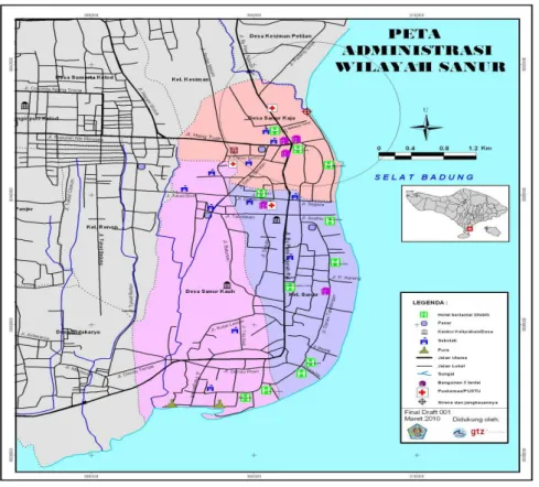
Administratively, Sanur is part of Denpasar district and located east of the town of Denpasar. It is bordering with Kelurahan Kesiman to the north and Kelurahan Pesangaran and Serangan to the south. Sanur consists of two villages and one village administration (Lurah). The total area is 105.700 square kilometer.
Figure 4: Administration Map of Sanur
Almost the entire area, except the mangrove area, is densely populated by a mix of local
residents, a smaller number of migrant worker and expatriates and a variable number of national and international tourists. Based on the data of the respective villages offices, the total population of Sanur consists of 5.541 families or 27.708 people.
Relevant actors in Sanur
The villages are headed by the “Kepala Desa” who is elected by the people of the respective community. The village administration (Kelurah) is lead by the “Lurah” who is appointed by the Head of District. Under the “Kepala Desa” and “Lurah” Have Kepala Lingkungan/Kepala Dusun and jointly provide the administrative functions to support the government development
program.
Beside the local administration structure, Sanur has a customary structure called “Banjar Adat”, whose leaders are called “Jero Bendesa Adat”. This customary structure has a special function for religious ceremonies, including the preservation of customary traditions.
Village Neighborhood Chiefs Customary Structure
Desa Sanur Kaja 8 Kepala Lingkungan 10 Banjar Adat Desa Sanur Kauh 10 Kepala Dusun 11 Banjar Adat Lurah Sanur 9 Kepala Lingkungan 8 Banjar Adat
In relation to the tourism sector, the Bali Hotels Association (BHA) has a strong commitment to improve tsunami preparedness in the member hotels.
The Sanur Development Foundation (Yayasan Pembangunan Sanur) is a non-profit social organization with the orientation to continuously develop the village and its surroundings. The Foundation function as an association for development, education, training for all community members of Sanur and to achieve development and prosperity for the community. They are also a mean of social communications amongst various components within the community.
BALAWISTA is a life guard organization under the Tourism Department established by the Denpasar Local Government. The main task is to watch the beaches and to provide information regarding safe area for swimming and water sports.
One of the tasks of the Association of Boat Owner “Sekehe Jukung” is to provide important information regarding ocean conditions to their members. This association is known as a very strong traditional group in Sanur.
Others local organizations to consider are the Fisherman Club, the association of art shop owners, the massages services club and surfer club.
Due to their vulnerability or vital function during emergencies schools and (public) health services (PUSKESMAS, clinics) should be involved.
Relevant aspects to consider for tsunami evacuation planning in Sanur
There are some basic conditions which need to be considered when defining realistic evacuation procedures for Sanur:
• Every tsunami is different! Sanur might suffer the impact of a smaller tsunami but also the worst case might happen. Due to the infrequent occurrence of tsunamis, information regarding their possible impact, occurrence and run up heights is very uncertain. It must be assumed that no reasonable action can take into account all possible risk.
• Due to the threat of near field tsunamis the warning time and hence time for evacuation is very short. A tsunami hazard assessment reveals estimated arrival times (ETA) between 20 to 80 minutes.
• Sanur is a low lying coastal plain area. No higher natural ground can be reached in reasonable time.
• Sanur counts with a number of big and strong hotel buildings, which can play an important role for vertical evacuation.
• Sanur is visited by big number of tourists who – in general - are not very familiar with the location and the tsunami threat.
• Some hotels related to the BHA have been develop own procedures to take care of their guests.
• Sanur was the historic development of Bali and has a diversity of cultures and customs in Denpasar District.
Taking into account this consideration the working group concluded that the despite the short time frame it will be recommended to prioritize horizontal evacuation of the red zone. For people staying at the beach or in one of the bigger hotel buildings, which are suitable for vertical
evacuation, at the time of a strong earthquake or the first tsunami warning it might be safer to look for shelter in one of the designated vertical evacuation buildings. As the yellow zone cannot be regarded as a safe zone during major tsunami events, people staying in this zone should be instructed to move to higher floors if possible. It was also concluded that the involvement of the private (tourism) sector is crucial for the development and implementation of a realistic
evacuation strategy and procedures.
These above mentioned considerations and conclusions have been taken into account for the development the overall strategy and procedures of tsunami evacuation for Sanur
III.The strategy and the procedures for Sanur
The tsunami evacuation strategy in Sanur encloses the following elements:
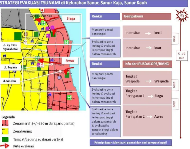
1. Two zone concept
The hazard zone is divided into a red and a yellow zone. The red zone is considered the most dangerous zone with a high probability to be affected by tsunami waves. The yellow zone is considered to be safe in most cases, except “worse case scenarios”. These cases are considered less probable but cannot be excluded.
The zoning takes into account the inundation areas visualized in the official Tsunami Hazard Map for southern Bali, but is not following the division in accordance with the warning level. The evacuation zoning in Sanur follows the approach, that the red zone covers the inundation area of an “average” tsunami event as well as the high impact area of even a bigger tsunami. The division between the yellow and red zone goes along the By-pass Ngurah Rai, which is an easy to remember landmark in Sanur.
The evacuation strategy is related to the advisory and warning levels of InaTEWS and the occurrence of natural warning signs. As a general rule people in the risk areas should move away from beaches and riverbanks close to the coast whenever experiencing ground shaking from an earthquake.
In Sanur the agreed procedures in case of earthquakes or tsunami warnings are:
1. For slightly felt earthquakes and the InaTEWS Advisory level (WASPADA) leave the beach and riverbanks immediately. Further evacuation is not considered necessary and no official call for evacuation will be issued.
2. In cases of strong felt earthquakes and InaTEWS Warning Level 1 (SIAGA) evacuate immediately the red zone or look for shelter in higher buildings. The yellow zone is considered ‘Safe Area” during Warning Level 1
3. In case of InaTEWS Warning Level 2 (AWAS) a call for “full scale evacuation” will be announced. Evacuate immediately the red zone or look for shelter in higher buildings. People in the yellow zone also go for shelter in higher floors.
Figure 5: Overall tsunami evacuation strategy for Sanur
2. Modes of evacuation
As the red zone is comparatively small and buildings (mainly bigger hotels) suitable for vertical evacuation are located mostly close to the beach, horizontal evacuation by foot is the preferred mode of evacuation in Sanur. Nevertheless, people who are staying in the bigger hotels or at the beach at the time of a strong earthquake or a tsunami warning might not be able to leave the red zone within short time and should seek shelter on higher floors (3rd floor or higher) in strong buildings. If seeking shelter in hotel buildings located at the shoreline the shelter area should be located in a part of the building which is as high and as distant to the shoreline as possible. Hotel guests shall follow procedures and guidance provided by their hotels.
It would be recommended, that people staying on the beach could seek shelter in a bigger hotels which are ready to receive nonresident people for evacuation purposes. However, this strategy requires the identification of such buildings, agreements with the hotel management, preparation of hotel staff and information the public in general.
Some few buildings have been already identified as options for vertical evacuation shelter for the general public. More buildings should be identified in the next future and arrangements made with the owner to assure accessibility during emergencies.
People in the red area should do evacuation by foot only. It is not recommended to use vehicles and motorcycles as it can be expected that all roads will be blocked by traffic jam.
3. Evacuation routes
Main evacuation routes from the red to the yellow zone are Jalan Danau Poso, Jalan Danau Buyan, Jalan Segara, Jalan Matahari Terbit, Jalan Shindu, Jalan P Karang, Jalan Duyung, Jalan Kesuma Sari, Jalan Pengembak.
At several strategic locations Traffic Control Points have been identified to prevent that traffic can flow into the red zone during a tsunami emergency. This issue still need to be consulted with the local traffic police.
4. Trigger for evacuation and dissemination of warning & guidance
As a general rule it is agreed that people in the risk areas should move away from beaches and riverbanks close to the coast whenever experiencing ground shaking from an earthquake. In cases of strong felt earthquakes people should leave the red zone or look for shelter in higher buildings.
Official calls for evacuation will be based on warning messages from the National Tsunami Warning Center at BMKG in Jakarta. Tsunami warning will be provided by the National Tsunami Warning Center at BMKG Jakarta within 5 minutes after the occurrence of a tsunamigenic earthquake. Warnings are broadcasted via national TV and radio.
BMKG will distinguish between 3 different warning levels1 as follow:
1. Advisory level / WASPADA: if the predicted wave height is less than 0,5 meter 2. Warning level 1 / PERINGATAN: predicted wave heights between 0,5 – 3 meter 3. Warning level 2 / AWAS: predicted wave heights bigger than 3 meter
1
The 3 Levels warning scheme is expected to be introduced by mid 2010. Until then a 1 level warning scheme will stay in place
In Bali the official call for evacuation will be made by the Province Emergency Operation Center in Denpasar. The call for evacuation will be announced via the siren (3 minutes continuous sounding) and local radio and TV stations.
The BHA has already established an own communication network to provide guidance to the associated hotels.
At village level it is recommended to promote the use of traditional means (wodden gongs) to inform the local residents.
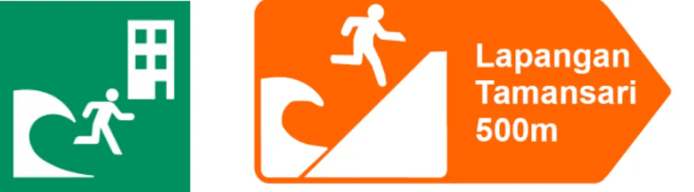
5. Evacuation Signage
The working group suggests installing Information Signboards along the beach of Sanur to disseminate tsunami evacuation information to the public. The signboards should also inform about early warning procedures.
Vertical evacuation shelter buildings, which are officially recognized, should be identified clearly by the respective signage.
Figure 6: tsunami evacuation signage for vertical evacuation shelter building and horizontal evacuation
It was also suggested not to set up tsunami evacuations signage all over the city to mark tsunami evacuation routes. Only in selected strategic location tsunami evacuations signage will be placed to indicate evacuation routes. Information on evacuation routes will made available to the general public via Information Signboards and leaflets.
IV.Recommendations for next steps
Even though an agreement on an evacuation strategy, evacuation zones and general procedures has been reached during the recent planning process, these achievements are only considered a first step to establish adequate and detailed procedures for tsunami evacuation in the highly populated area of Sanur. Additional expertise from science, engineering and related fields of disaster management should be sought after to improve the plan in the future.
To support the follow up and to improve evacuation planning in Sanur and neighboring areas, this chapter provides some recommendations for further planning and implementation.
1. Recommendations regarding assembly areas and vertical shelter buildings
The evacuation strategy for Sanur, beside horizontal evacuation also considers vertical evacuation in certain circumstances. So far only few buildings for vertical evacuation have been identified and mapped. To assign a building as vertical shelter it is necessary not only to check the structural design of the building and the general suitability for evacuation purposes (accessibility, capacity) but also to negotiate agreements with the owner and define procedures for the emergency case.
To receive people evacuating from the red to the yellow zone and to provide first assistance, procedures for the assembly areas should be defined.
2. Recommendations for further involvement of relevant sectors and stakeholder
There are a number of institutions and facilities in Sanur which are either particular vulnerable or play an vital during an tsunami emergency and need to be addressed in a specific way:
Special attention should be paid to schools and other educational institutions as well as health service facilities (private clinic, community clinic, hospital). They should be encouraged and supported to develop their own institutional evacuation plans and procedures. The later ones might also need special plans to be able to provide medical services during tsunami emergencies.
As a main and international tourist destination it is mandatory to involve the tourism sector institutions and organizations in the evacuation planning process. The Bali Hotel
Association (BHA) has installed an own TEW communication network providing
information and guidance to hotel managements in emergency situations and supports their members working among their members to define and implement tsunami preparedness and evacuation procedures.
Cooperation and agreements between communities and the hotel sector prior to any tsunami emergency can help to take the edge off an predictable chaotic situation after an strong earthquake or once a tsunami warning has been issued. The experience from Tanjung Benoa could be used a reference for similar activities in Sanur.
The BALAWISTA (Beach Life Guards) shall be involved as they can play an important role in providing guidance to the beach visitors and supporting the evacuation process. There are four duty posts, each staffed with three to four people along Sanur Beach: (1) Matahari Terbit beach, (2) in front of Lemayur Museum, (3) Segara Ayu and (4) Semawang beach. Duty time is from 7 am until 7 pm. Each post is equipped with VHF radio communication.
Related to Sanur beach activities, there are a number of community groups which could support an evacuation process. They represent small commercial activities like seller of goods (souvenirs, food) or services (beach equipment rentals, massage). These groups are controlled by the traditional structure in Sanur.
The Sanur Development Foundation (YPS) could play an important role in sharing information about tsunami early warning and evacuation procedures with the community.
3. Recommendations for local capacity building and to raise awareness
Local capacity building and awareness campaigns in Sanur are necessary, as the basic strategies and procedures of the evacuation plan need to be widely known and understood. It is recommended to address community groups in order to get a broader access to the target group. There are a number of local groups and organizations which can be addressed:
a) The Banjar Adat has responsibility to protect the local community and culture. The Banjar Adat still has significant influence on the community and their social activities. Therefore the Banjar Adat is considered an important community element to provide guidance to the community in emergency situations.
b) PECALANG is a traditional security guard under the Banjar Adat structure.
PECALANG has the responsibility to maintain the community secure and safe during daytime.
c) Almost each Banjar has a youth organization. This group might probably play an active role during the evacuation process. The youth is usually more dynamic and agile, and powerful to guide the community.
d) LINMAS is a civil protection brigade under the Lurah. LINMAS has the task to maintain security and safety in general. Their contribution during an evacuation process is to guide the community together with PECALANG.
e) The Kepala Lingkungan (Head of community group) under the Lurah structure will have the task to mobilize the community together with other relevant actors.
f) The Woman Organization (PKK) can play an important role during the response phase and to secure and protect the children.
g) BALAWISTA is an organization of beach life guards with numerous members in Bali.
It is important to make sure that all local specific contents for awareness campaigns are in line with the concepts and strategies discussed and approved by the local community and
administration. The basis for all detailed evacuation planning in Sanur should be the approved reference map (see next page). A simpler version of the map has been developed for the public in general.
For the public in general and especially visitors it is required to provide short and concise information about evacuation procedures and routes in different languages. For this purpose it is intended to put up billboards on strategic locations along Sanur beach. Leaflets are another possibility to disseminate basic information. The hotel sector should be involved to provide information to their guests.
For local residents and local institutions concepts and materials for tsunami awareness campaigns (socialization) have been developed. First socialization events have been implemented already. During the awareness campaigns the communities receives locally specific and relevant information regarding the tsunami threat, early warning system and evacuation procedures and are encouraged to define own preparedness procedures and local evacuation maps. For the implementation of the awareness campaigns a group of Balinese master trainer and local facilitators have been prepared. For Sanur 6 local facilitators are available (contact data in Annex 2).
Annex 1: The roles and responsibilities of local institutions
No. Main Task Key Institutions Supporting Institutions Detailed Tasks
1. Receive warnings from BMKG or PUSDALOPS
1. Office of Kelurahan Sanur, Sanur Kaja and Sanur Kauh village Office (validated by Lurah Kuta)
2. BHA network in Sanur
1. Coast Guard
2. Village Community Protection 3. Police Force
4. Armed Force
5. ………
• Receive and assess warnings
• Forward the guidance issued by the District or Provincial Government via PUSDALOPS to the community
2. Disseminate warnings to community and visitors/tourists
1. Office of Lurah sanur, sanur Kaja and Sanur Kauh. 2. Local media
3. BHA network 4. Police 5. TNI 6. PMI
1. Pecalang
2. BALAWISTA
3. Others relevant local Institution
• Disseminate warnings received
• Provide guidance for the people
3. Guide and direct community and visitors/tourists
1. SAMAPTA Police 2. TNI
3. Head Banjar (Kelian Banjar) 4. PECALANG (Traditional
security)
5. Teachers (for students that need to be evacuated)
1. Hotel security personnel 2. Management of assigned
hotels
3. Kelian Banjar and their apparatus
• Guide the public to evacuation routes and safe places
• Cooperate with institutions responsible for safety and security to secure evacuation routes
4. Traffic management 1. POLRI
2. Dinas Perhubungan (Office of Transportation)
1. Hotel security personnel 2. Pecalang
3. Linmas
• Direct traffic in and out of the beach area
• Secure evacuation routes
5. Safety and security 1. POLRI
2. Pecalang 3. Kelian Banjar
4. Police Government (Polisi Pamong Praja)
4. TNI
5. Community Protection personnel (LINMAS)
• Generally responsible for the safety and security of the people
6. Services at the temporary shelter Under Lurah and Kepala Desa supervision:
1. Puskesmas Kuta 2. Rumah sakit swasta di
sekitaran Kelurahan Kuta 3. PMI
• Provide basic health services (first aid)
• Provision for basic needs if necessary
Annex 2: Contact data
Institution Representative Phone Email
BPBD Denpasar Dr. I Made Sudhana Satrigraha.M.Si O816583123
Lurah Sanur Ida Bagus alit SSN 0812369148
Kepala Desa Sanur Kaja Ida Bagus Paramartha, SH. MM 081 246 174 77
Kepala desa Sanur Kauh Made Dana 081353154002
Bali Hotel Association (BHA) 0361-227600 info@balihotelsassociation.com
Master Trainer for Tsunami Awareness Campaigns in Bali
Master Trainer Institution Phone Email
Agus Sugianto Dinas Kesehatan Kabupaten Badung +62 85239195193 agussugianto_dps@yahoo.com
Dewi Reny Aggraeni PMI Bali Chapter +6281219968115 wie_tmt118@yahoo.com
MR. I Gusti Ngurah Puspa Udiana S.kom
PUSDALOPS Bali Province +628175061263 ignpudiyana@gmail.com
Widi Artanti GTZ-GITEWS +628119849129 widiartanti@gmail.com
Local Facilitator for Tsunami Awareness Campaigns in Sanur
Local Facilitator Phone Local Facilitator Phone
I Wayan Parka +628123613130 IB Putra +6287860001945
I Nyoman Sudi +62361783364 A A Aryateja +628123618969 / +623618622229
I Ketut Suta +6281338379336 I Kadek Mudayasa +62817553632
I Gst Made Suarna +628179705001 Putu Nurhayati +6287860295331
Luh Priati +623618582236 Ni Nyoman Wirathi +62361271200